ResjJonse to Dr C. de Q. Robin's /JleaJor fixed axes oJ reference ill glacier .... If, on the other hand, you first measure by some means the horizontal and.
CORRESPONDENCE
SIR,
ResjJonse to Dr C. de Q. Robin's /JleaJor fixed axes oJ reference ill glacier mechanics
Dr Robin and I both agree th a t th e essential poin t is whethe r the use of surface-orien ted axes mak es the phenomenon easier to und erstand. Robin mainta ins that with this system th e variables, such as O z , change in m eaning from point to point, whereas with horizontal and vertical cartesian axes variables like O z " have the same meaning throughout th e an alysis of a complete profile" . I do not think that such a distinction can be made. Both m y variabl es and Collins's var iables retain th eir m eanings throughout, simply because both of us define them precisely. It is true that Collins's O z retains the same direction while my O z does not. But my O z retains the m eaning that it is th e stress compon ent normal to the upper surface, while Collins's O z retains the meaning that it is the verti cal stress. Both m eanings are readily und erstandabl e, but wh en it com es to interpreting changes in the varia bles I believe that it is, in fa ct, more useful to d e fin e the variabl es on my system of axes ; for example, in my system O z is always th e same (equal to atmospheri c pressure) on th e upper surface, wh ereas in Coli ins's system O z on th e upper surface changes in a complicated way. Simila rl y, in my system it is easy to und erstand the fact that T xz on the upper surface is constant (zero in fact ), whereas in Collins's system T xz on th e upper surface und ergoes changes that are comparativel y difficu lt to comprehend . Or take E; in m y system it is th e surface strain-rate m easu red parallel to the surface, a nd it retains this meaning throughout th e analysis of a profile ; it is at leas t as simple to think of changes in this surface strain-rate as it is to think of changes in horizontal strain- ra te . Such considerations are m erely suggestive of th e va lue of a surface-oriented coordinate system; the full justification is th e compara ti ve simplicity of the final result wh en ex pressed on this system. The same point may be made in another way that is not as frivolous as it may at first appear. Robin' s plea is for "fixed axes of reference" , that is for a set of rec tilin ear cartesian axes that a re fix ed in direction throug hout th e whole profile. But he does not, in fa ct, obey his own prescription. Owing to th e curvature of the Earth th e direc tion of th e vertical ch a nges along his m easurem ent line by 7 X 10 - 3 radians, which is seven times his maximum elTor in slope m easurem ent. T acitly he allows his reference fra m e to rotate from point to point (and h e neglects th e small additional terms this produces in th e equations of equilibrium) because h e realises that th ere is nothing to be gained, and much to be lost, by adherence to a strictly rectilin ear set of axes. H e is thus really using axes that change in direction as one moves a long the profile. A co rrespondent might th en complain that since hi s axes a re not fixed it is d ifficu lt to comprehend th e mag nitude of the changes in th e para m eters h e uses . Robin could quite properl y reply that it is easier to comprehend , for example, th e cha nge in O x on his system, that is the chan ge in the horizontal stress d efin ed with res pect to th e local horizontal, than th e change in O x on a system of strictl y rectilinear axes, wh ere th e x axis would mak e a varying angl e with the horizonta l. Thus, by choosing axes following th e upper surface of the ice sheet, I am ca rrying one stage furth er a procedure that Robin himself uses when h e takes rectilin ear axes foll owing the geoid. The reason it is worthwh ile ta king this furth er step is that the fin a l equation is a local equation in th e se nse that it contains onl y quantities at fixed x , and not, for example, any quantities integrated over x. The local equa tion appears to take its simples t form on surface-oriented axes, a nd th e changes in quantities d efined on th ese axes seem to m e to be, if a nything, more comprehensibl e than th e changes in quantities defined on fixed axes. Wh ether th e changes in surface slope are ra pid or not does not seem to make any difference to th ese arguments. Dr Robin a lso questions the practical advantage of surface axes; h e states that th e fi eld m easu rem ents "all use a fix ed system of coordinates". This remark is puzzling, for th e m easurements Robin uses appea r to consist of slope values, values of accumu lation ra te, a nd thi ckness m easurem ents a lo ng a lin e in Greenland. Wh eth er i'1x is m eas ured horizontally or parall el to th e upper surface ca n make little practical difference in th e computations. Similarly, I ques tion wh eth er th e thi ckness measured verticall y is significantly different from the thickness m easured perpendi cul a r to the top surface. The practi cal appli cation to Robin 's data of the equation in my coordinate system would therefore appear to be virtua ll y identi cal to the computation he has alread y mad e . If m easured , rather than estimated, longitudinal strain-rates are to be used , a direct m ethod would be to m a ke repeated m easurements (by tell urometer ) of th e distan ces between stations along th e line. This gives E in my notation directly, and hence i'1E as the difference in strain-rate b etween successive interva ls. The stations selected d efin e a smoothed upper surface, and it is with respect to this surface that th e axes a re defined . If, on the other hand, you first measure by some m eans the horizontal and verti cal velocity components for the stations (whi ch is a much more difficult task) a direct computation
JOURNAL
OF
GLAC I OLOGY
gives € parallel to th e surface for each interval, and hence the difference f:J.€ between successive intervals. Thus no transformation of coordinates appears to be n ecessary. In short, I believe that my equations (w hi ch are th e same for small slopes as those of Budd, but with the variables more precisely defined) can be applied directly to the field measurements. Indeed th ey have already been applied- by Robin and Budd.
J. F.
H. H. Wills Physics Laboratory, University of Bristol, Tyndall Avenue, Bristol BS8 I TL, England 13 No vember 1969
SIR,
NYE
Glaciation of the north- western part oJ the Canadian Arctic Archipelago
In a recent paper (Paterson, 1969), I stated that th e islands in the north-western part of th e Archip elago are marked " unglaciated" on the Glacial malJ oJCanada. I a m grateful to Dr W. Blake, Jr for pointing out that, whereas m y statem ent is true for th e 1958 edition of th e map, it is not true fo r th e latest ( 1968) edition . On the 1968 m a p, only Banks Isla nd and a small part of southern M elville I sland are marked " ungl acia ted". It is now believed that th e remainder of th e islands were covered by a large ice shee t during th e last glaciation (Blake, 1970) .
W . S. B.
Polar Continental Shelf Project, De/Jartment oJ Energy, Mines and Resources, Ottawa, Ontario, Canada 17 December 1969
PATERSON
REFERENCES Blake, W. ,j r. 1970. Studies of glacial history in Arctic Canada. 1. Pumice, radiocarbon dates, and differential postglacial uplift in th e eastern Queen Elizabeth Islands. Canadian Journal of Earth Sciences, Vo!. 7, No. 2 , Pt. 2 , p.634- 6 4. Pa terson, W. S. B. '969. The Meighen Ice Cap, Arcti c Ca nada : accumul a tion , a bla tion and Aow. J ournal of Glaciology, Vo!. 8, No . 54, p. 34 ' - 52.
SIR,
Distorted ice stalactites as indicators of glacier movement
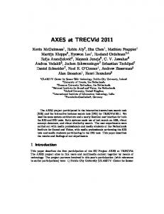
Du rin g August 1969 we were worki ng in th e Mt C astleguard locali ty, Alberta , Canada. The mounta in stands a t the eastern end of the Colum bia I cefield and hosts a number of small tempera te gla ciers of its own . One of these terminates at an a ltitude of 8 200 ft ( 2 5 00 m ) upon a broad gentle limestone bench. There was an ice cave at th e snout which could be followed up th e line of ice flow for approximately 100 m . A cross-section is given in F igure I. Inside th e cave, rock and glacier-ice surfaces were d ecorated with abund ant sublima tion ice d eposits.
___---_~----------T---.L /2/ 10 m
SURFACE
not 10 scale
~
CAV E
GL AC IER
GL ACIE R MOV EM EN T TOWAR O READER R OC K WA LL S VISIBLE
••-
7~7 {ilT llll l fllllllfllllllflll l l' II'11111111 1
'/
"':',~, ;
THROUGH ICE ICE WAL L S COVERED IN HE XAGONAL ICE CRYS:..:. T;.: A"' LS=--_ _ _- j
', .
Q Im
Fig.
I.
OR IENTAT ION OF FIG 2