Center for Analysis and Prediction of Storms (CAPS), University of Oklahoma, Norman, Oklahoma ... The Oklahoma Atmospheric Surface-layer Instrumentation.
Meteorol. Atmos. Phys. 80, 189±206 (2002)
Center for Analysis and Prediction of Storms (CAPS), University of Oklahoma, Norman, Oklahoma
Land-surface scheme validation using the Oklahoma Atmospheric Surface-layer Instrumentation System (OASIS) and Oklahoma Mesonet data: Preliminary results J. A. Brotzge and D. Weber With 11 Figures Received November 18, 2001 Revised December 28, 2001 Summary
1. Introduction
The Oklahoma Atmospheric Surface-layer Instrumentation System (OASIS) is a recently-developed observational system that collects, archives, and quality controls atmospheric, surface, and soil data in real-time from 90 stations across Oklahoma. Ten of the 90 sites, termed ``super sites'', are equipped with additional sonic anemometry and four-component net radiometers to provide complete observations of the surface energy balance. Oklahoma Mesonet and OASIS data are used in this study to validate the sensitivity and accuracy of a land-surface scheme within a numerical prediction model. The Advanced Regional Prediction System (ARPS) is a three-dimensional, nonhydrostatic mesoscale model developed by the Center for Analysis and Prediction of Storms (CAPS) at the University of Oklahoma. The land-surface model (LSM) used within ARPS is the Interactions Soil Biosphere Atmosphere (ISBA) scheme. Mesonet and OASIS data collected from the super site located in Norman, Oklahoma, are used as veri®cation for the ISBA. Research presented in this study outlines the challenges in developing, maintaining, and using in-situ data for model validation. Such problems as instrument error, surface heterogeneity, and non-closure of the surface energy budget limit data accuracy. Preliminary results of model validation focus on the sensitivity of the soil physics within the ISBA scheme. Model sensitivity to vegetation cover, surface roughness, and soil type are investigated. Furthermore, several recent improvements to ISBA are evaluated and compared to observations. This study concludes that the sensitivity of the ISBA to a priori soil and vegetation type is detrimental for this scheme to be used in a mesoscale model without improved treatment of surface heterogeneity.
This paper describes the initial use of Mesonet and OASIS data as veri®cation for the interactions soil biosphere atmosphere land-surface model. Previous routine, real-time measurements of surface ¯uxes and soil moisture were limited to ®eld projects with short, high-intensive observational periods. Field programs such as HAPEX-MOBILY (Andre et al., 1986), the First ISLSCP Field Experiment (FIFE; Sellers et al., 1988), and MONSOON 90 (Kustas et al., 1991) provided rich data sets for advancing knowledge of land-surface interactions. However, these ®eld experiments were limited in size and scope, and did not allow for long-term (multi-seasonal) nor large-scale (regional to statewide) estimates of surface and ground parameters. The notable difference with the present study is the completeness of the data collected in addition to the spatial and temporal extent of the new data set. As described within, the available data will allow researchers to scrutinize the numerical frameworks over a complete set of weather phenomena and improve the methods associated with land surfaces schemes. The current research efforts at the Center for Analysis and Prediction of Storms (CAPS) includes a rigorous validation of a number of physics components used by the
190
J. A. Brotzge and D. Weber
Advanced Regional Prediction System (ARPS) described by Xue et al. (2001a). The Oklahoma Atmospheric Surface-layer Instrumentation System (OASIS; Brotzge et al., 1999) is a unique, statewide network sponsored by the National Science Foundation which collects, quality controls and archives radiation, surface ¯uxes, and soil data in real-time on a continuous basis. OASIS enhanced the existing observational capabilities of the Oklahoma Mesonet to allow for continuous monitoring of the total surface energy budget. OASIS data have been collected and archived from 90 Mesonet sites statewide every 5 to 30 minutes since 1 January 2000. The primary objective of OASIS is to develop a long-term, large-scale data set of ®ne spatial and temporal resolution against which remote sensing algorithms and numerical models can be veri®ed. This is the ®rst such study to use data from OASIS for model veri®cation. The Advanced Regional Prediction System is a three-dimensional, nonhydrostatic mesoscale model developed by the CAPS at the University of Oklahoma. The ARPS is used as both a forecasting and research tool primarily but not limited to the prediction of convective storms. An accurate land-surface scheme for use in a mesoscale model is critical to forecasting cloud formation and convection. The land surface and soil package of ARPS (Xue et al., 2001b) includes the Interactions Soil Biosphere Atmosphere (ISBA) scheme described by Noilhan and Planton (1989), and Pleim and Xiu (1995). While the ISBA scheme has been extensively tested against atmospheric and surface ¯ux data (Jacquemin and Noilhan, 1990; Noilhan et al., 1991; Bougeault et al., 1991; Mahfouf et al., 1995; Noilhan and Mahfouf, 1996; Xiu and Pleim, 2001), the land surface model (LSM) has not been as thoroughly tested against soil observations. In addition, several recent improvements to ISBA (Noilhan and Planton, 1996; Xiu and Pleim, 2001) have not yet been included into the ARPS scheme. This paper outlines the many challenges in developing, maintaining, and using in-situ data for model validation. Section 2 presents an overview of the Mesonet and OASIS data including the limitations and operational challenges with the collection and representativeness of in-situ
data. Instrument limitations and failures, spatial representativeness, and inconsistent closure of the surface energy budget each contribute to measurement error and uncertainty. In addition, model sensitivity to initialization and surface heterogeneity makes model veri®cation even more dif®cult. Each of these problems is discussed in Sect. 2. Section 3 brie¯y reviews the ISBA scheme and the study methodology. Preliminary results from model validation of ARPS using OASIS and Mesonet data are provided in Sect. 4. 2. Mesonet and OASIS data overview The Oklahoma Mesonet (Brock et al., 1995) provides the infrastructure upon which the OASIS is built. Approximately 90 Mesonet sites have been enhanced to allow net radiation, ground and sensible heat ¯uxes to be estimated directly (Fig. 1). Latent heat ¯ux is estimated as the residual of the surface energy budget. Skin temperature and soil moisture also are measured directly at the 90 sites. Ten of the 90 OASIS sites, termed ``super sites'', have additional sonic anemometry and 4-component net radiometers, which allow more accurate and precise measurements of net radiation and sensible and latent heat ¯uxes. The ten super sites are equipped with redundant instrumentation and multiple methods of measurement to allow for improved quality control of the data. A super site has been selected in each of Oklahoma's nine climatic zones, to provide a diverse yet simultaneous set of observations from across the state. 2.1. Instrumentation and measurement procedures The measurement methods used by OASIS are summarized in Table 1. A detailed description of the sensors is found in Brotzge (2000). What follows is a brief summary of the assumptions and unique problems associated with each measurement method. This review is used foremost to develop an approximate error estimate associated with the data set. Second, problems in measurement are important to be understood in context when used for comparison against modeled data. As discussed by Noilhan et al. (1991), model results most likely will not exactly reproduce the surface observations, either because of
Land-surface scheme validation using OASIS and Mesonet
191
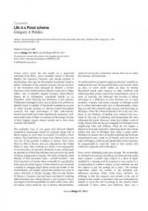
Fig. 1. State map displaying 89 OASIS sites (circles and triangles) and ten OASIS super sites (circles) Table 1. Measurement methods used at OASIS standard and super sites Measurement technique
Net radiation (Rn) Sensible heat ¯ux (H) Latent heat ¯ux (LE) Ground heat ¯ux (G)
90 Standard sites
10 Super sites
Domeless net radiometer, (NR-Lite) Gradient method (Paulson 1970; Brotzge and Crawford 2000) Residual from the energy balance, LE Rn H G Combination method, using the mean of two heat ¯ux plates, soil moisture at 5 cm, and average soil temperature between 0 and 5 cm
Four-component net radiometer, (CNR1) Eddy covariance using sonic anometery
nonrepresentativeness of the measurements or model de®ciencies. Thus, a correct interpretation of the observations and modeled data require a complete understanding of both observational and modeling de®ciencies. 2.1.1. Net radiation Shuttleworth (1991) describes net radiation as one of the most dif®cult parameters to measure accurately. For this reason, net and four-component radiometers were installed at the OASIS super sites. The net radiometer used by OASIS is the NR-Lite, a recently developed sensor, which is relatively low-cost, is nearly maintenancefree and does not require the use of polyethylene domes that can degrade over time. However, the simplicity of the design permits greater
Eddy covariance using sonic anometer and Krypton hygrometer Combination method, using the mean of two heat ¯ux plates, soil moisture at 5 cm, and average soil temperature between 0 and 5 cm
sensitivity to operational errors. Brotzge and Duchon (2000) identi®ed several limitations of the sensor. These problems include poor initial calibration, and a degradation of performance during high winds and low sun angles, and during precipitation. The four-component radiometer, the CNR1, comprises four separate sensors housed in a single unit, allowing incoming and outgoing shortwave and longwave radiation to be directly observed. A heating element, embedded within the body of the sensor, is activated during certain weather periods to minimize the effects of dew, frost or precipitation. The sensor is much more expensive than the NR-Lite but does not incur the operational problems associated with wind or precipitation. Both radiation sensors are mounted at a height of 2 m.
192
J. A. Brotzge and D. Weber
Data from the NR-Lite and CNR1 were collected and archived from the ten super sites (Brotzge, 2000). Comparisons between the colocated sensors revealed minimal differences between them (