system located on the eastern seaboard of Canada, extending from .... Transport Canada from May through November of each year along ..... F. Miiller, 1776).
Vol. 83: 15-34, 1992
l
MARINE ECOLOGY PROGRESS SERIES Mar. Ecol. Prog. Ser.
1
Published July 2
Large-scale ecological patterns: discontinuous distribution of marine benthic epifauna* P.-L. Ardisson*', E. Bourget*** GIROQ, Departement d e biologie, Universite Laval, Quebec, Quebec, C a n a d a GIK 7P4
ABSTRACT Spatial distribution patterns of benthic littoral fauna were studied over a 12 yr penod in a large subarctic ecosystem, the Estuary and northwestern Gulf of St Lawrence Binary presenceabsence data obtained from suspended collectors (navigation buoys) moored yearly, from May through November, were used to exanune ecological affinities a n d spatial heterogeneity In species distilbution Analyses of species CO-occurrence followed by arithmetic average clusteiing conducted at large (whole system, Gulf, Estuary) and ~ntermediate(North Shore plus Lower North Shore) spatial scales revealed a recurrent specles association (composed of 12 species including Obelia longlsslrna, Mytilus edulis, Balanus crenatus, Hiatella arctjca, and S e m ~ b a l a n u sbalano~des)characterizing the entire l of larval dispersal m a d e Estuary-Gulf area Frequency analyses carried out along 3 p o t e n t ~ apathways lt possible to identify major spatlal discontinuit~esin species distribut~onas well a s the community n members contributing most to them The outstanding changes in composit~onand d ~ s t r ~ b u t l oof benthic species throughout the study area were highly coincident with well-defined physiographical ( e g presence of stralts, Islands, contour of shoreline) and hydrographical ( e g zones of fieshwater inputs, upwellings, frontal zones) features of the system, particularly along the e s t u a r ~ n egradient
INTRODUCTION
Littoral benthos distribution responds to 2 principal axes of variability, the vertical axis (e.g. influence of hydrological factors, water column stability, food supply, and behavioural patterns on zonation of species) and the horizontal axis (e.g. hydrodynamic control of larval migration and transport of adult individuals with horizontal distance), even though in nature, interactions of both axes are usually observed (Underwood & Denley 1984, Mann 1986a, b, Possingham & Roughgarden 1990). While distribution along the vertical axis has been thoroughly studied on shores (e.g. zonation studies), few studies have dealt with discontinuities along ecological gradients in highly variable environments such as estuaries and shelves, except in general terms (Southward 1967, Sanders ' Contribution to the program of GIROQ (Groupe Interuni-
vers~taired e Recherches Oceanographiques d u Quebec) "Present address: Institut Maurice-Lamontagne. 850, route d e la Mer C.P. 1000. Mont-Joli, Quebec, Canada G5H 324 '"Addressee for correspondence O Inter-Research 1992
1968, Kinne 1970, Wolff 1983). The present study, which is concerned only with the honzontal axis of variability, examines the composition and distribution of the littoral epibenthic community of a large subarctic ecosystem, the Estuary and northwestern Gulf of St. Lawrence. Our main objectives were (1) to determine the spatial affinities (CO-occurrence)of species colonizing this area, (2) to characterize their distributional discontinuities, and (3) to identify the most relevant environmental factors responsible for these discontinu~ t i e s The . size a n d physical heterogeneity of this system (see below) and collecting methods used allowed us to study the changes in composition and distribution of species under a large range of environmental conditions, in the absence of any direct influence of the vertical axis caused by the tidal emersion-immersion cycle. Our focus was on benthic littoral species possessing planktonic larval stages, sampled on suspended collectors moored in open coastal waters within the surface 0 to 2 m depth layer. Therefore, discontinuities, such as observed here, a r e more likely to be associated with hydrodynamic singularities and physico-chemical
Mar. Ecol. Prog. Ser. 83: 15-34, 1992
16
characteristics of the water mass, rather than with topographic features of the bottom and shoreline. Furthermore, the limits of species distributions observed in this study may differ from those observed on shores. Thus, our approach should be viewed as a means of highlighting potential dispersal ranges rather than absolute limits of species distribution. Indeed, on shores, the environmental factors are certainly more constraining for survival and growth than those observed in the water column offshore.
STUDY AREA
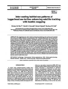
The Estuary and Gulf of St. Lawrence is a coastal system located on the eastern seaboard of Canada, extending from about 46 to 52" N and from 56 to 73" W (Fig. 1A). It receives a large input of freshwater from the St. Lawrence River and other tributaries, and exchanges water, heat, and salt with the North Atlantic Ocean through 2 main openings: Cabot Strait and the Strait of Belle-Isle. The former is 104 km wide with a maximum depth of 480 m: while the latter has a minimum width of 16 km and a sill depth of 60 m (Dickie & Trites 1983). On the basis of morphological and hydrographical characteristics (e.g. Brunel 1970, Neu 1970), the Estuary-Gulf system can be divided into 4 distinct regions (Fig. 1):(1)The Fluvial Estuary, the well-mixed freshwater portion of the St. Lawrence River under tidal influence, from ile dlOrleans u p to Lake SaintPierre some 180 km upstream. (2) The Upper Estuary, from h e dPOrleans to the mouth of the Saguenay. Mixing of the freshwater outflow of the river with the saltwater intrusion is largely carried out in this portion of the system. This 150 km long region exceeds 50 m in depth only in few places. It is characterized by a seaward surface salinity gradient ranging from 0 to 25 %O (Lavoie 1970, Neu 1970), and a maximum turbidity zone located between ile drOrleans and ^Ile aux Coudres (Kranck 1979, Lucotte & drAnglejan 1986). Maximum summer surface temperatures (20 "C) are found near ile dlOrleans, decreasing to 8 'C downstream near the mouth of the Saguenay (Vigeant 1987). (3) The Lower Estuary from the Saguenay Fjord down to Pointe-des-Monts on the north shore and Les Mech~nson the south shore. This 200 km long channel expands from a depth of less than 40 m and a width of 24 km at the western end to a depth of 340 m and a width of 46 km at the eastern end where it opens into the Gulf. This area is characterized by surface salinities varying from 24 to 30 760 and a pronounced stratification in summer. The summer temperatures of the surface layer vary from 4 to 12 "C with a more pronounced north-south than east-west gradient (El-
Sabh 1979, Vigeant 1987, Petrie 1990). (4) The Gulf, seaward from the Pointe-des-Monts-Les Mkchins axis. One of the main bathymetric features of this region is the Laurentian Channel (with 2 branches, the Esquiman and the Anticosti Channels), with an average depth of 420 m and stretching over 1000 km from the Atlantic Ocean (through Cabot Strait) up to the head of the Lower Estuary. It is characterized by surface salinities varying from 27 to 32 %O and a 3-layered summer temperature structure. The surface layer ranges in thickness from 10 to 30 m depending on the location and the month (Lauzier et al. 1957, Banks 1966). In the northwestern sector of the Gulf, the highest temperature values are observed in the Gasp6 Peninsula
I
1-
Fluvlal Upper Estuary - I - ~ s t u a t y -
Lower
-1
~stuafy
I
Fig. 1. The Estuary and Gulf of St. Lawrence. (A) Physiographic features; (B) summer surface circulation pattern in the Estuary (modified from El-Sabh 1977a); (C) summer surface circulation pattern In the Gulf (modlfled from El-Sabh 1976) S.B.I.. Strait of Belle-Isle; E.C. Esquirnan Channel; J.-C. P.: Jacques-Cartier Passage; A.C.. Anticosti Channel; A.I.. Anticosti Island
Ardisson & Bourget: Large-scale ecological patterns
region (4 to 16 "C), intermediate values in both the western North Shore region (2 to 15 'C) and the Jacques-Cartier Passage (3 to 14 "C), and the lowest values in the Lower North Shore region (1 to 13 ' C ) (Vigeant 1987, Petrie 1990). Water motion in the study area is maintained by runoff and other forcing factors such as tides, winds, heat fluxes, and geostrophy. In the Upper Estuary, the circulation pattern is based on a 2-layer flow system in which the lower more saline layer flows upstream while the upper fresher layer flows seaward. Under the influence of topography and geostrophy, the lower flow is deflected towards the north and the upper flow towards the south shore. The seaward flow is reinforced at the head of the Lower Estuary by the braclush outflow of the Saguenay Fjord and continues until it reaches the (ile du) Bic-Rimouski region. Here, the buoyant flow divides in 2 branches. One flows along the south shore and gives rise to the Gaspe Current, a strong coastal jet flowing seaward along the Gaspe Peninsula (Benoit et al. 1985, Mertz et al. 1988). The other flows northward across the Estuary and then divides in 2 further branches: one turns to the west and moves upstream off Les Escoumins, while the other moves seaward along the north shore. At the estuary-gulf boundary near Pointe-des-Monts, the influence of the cyclonic Anticosti gyre and the topography of the shoreline deflect this current towards the south coast where it mixes with the Gaspe Current (Neu 1970, El-Sabh 1979).This surface circulation pattern gives rise to 2 eddies: a large anticyclonic one centered between the mouth of the Estuary and Baie-Comeau, and a smaller cyclonic eddy between Rimouski and mouth of the Saguenay cross sections (El-Sabh et al. 1982, Mertz et al. 1989) (Fig. 1B). Another striking feature is the upwelling of cold waters from the deeper intermediate layer at the head of the Laurentian Channel. These waters have a strong impact both on the surface characteristics of this region and on the Gaspe Current transport (Ingram 1979, Bugden 1981). In the Gulf the general surface circulation is counterclockwise, with a 2-way flow in Cabot and Belle-Isle Straits (El-Sabh 1977a, Petrie et al. 1988). Several gyres, 20 to 100 km in diameter, occur in this area but their location and persistence vary appreciably, except for the Anticosti gyre which persists at all times. This cyclonic gyre, together with the density front formed at the entrance of the Gulf and the Gaspe Current, are the main features of the surface circulation in the western portion of the Gulf. The Gaspe Current remains a striking feature until it enters the open Gulf. It then spreads out in a general southeasterly direction and becomes weaker over the Magdalen Shallows. Part of this water is recirculated around the Gulf and
17
part exits to the Atlantic Ocean through Cabot Strait (El-Sabh 1976, Dickie & Trites 1983) (Fig. 1C). The northern portion of the Gulf receives considerable freshwater input from surrounding rivers and experiences episodic upwellings of cold waters, presumably induced by winds and tidal mixing (Lauzier et al. 1957, Steven 1974, Lacroix et al. 1985).
MATERIALS AND METHODS Sampling of fauna. Navigation buoys, moored by Transport Canada from May through November of each year along shores of the Estuary and northwestern Gulf of St. Lawrence (Fig. 2), were used as collectors. The Estuary includes here the Lower and Upper Estuary as well as the lower hundred kilometres of the Fluvial Estuary. Sampling was carried out from 1974 to 1985 (except in 1978 and 1979), on up to 239 collectors per year. During winter the buoys were scraped and painted. The paint used contained no antifouling agents and, as a result, the buoys moored each spring had clean surfaces offering apparently little or no resistance to larval settlement. Throughout the annual 7 mo immersion period, the buoys were colonized by sessile organisms, presumably according to the relative abundance of their planktonic larvae. Since the buoys were moored and retrieved each year over short periods of time (about 2 wk), little or no seasonal differences in abundance among regions were introduced. The attached invertebrate fauna was sampled following the methods described in Fradette & Bourget (1980, 1981), Ardisson et al. (1990), and Ardisson & Bourget (1991). First, all macroscopic species observed on the buoys were collected and identified. Second, the species composition on each buoy was corroborated by examining a 0.01 m2quantitative sample obtained from the area of maximum abundance of each one of the following dominant species: the hydroid Obelia longissima; the bivalves Hiatella arctica and Mytilus edulis; and the cirripedes Semibalanus balanoides, and Balanus crenatus. The areas of maximum abundance were determined by visual inspection. Since the species distributions on the buoys were most often patchy, sampling the community in the areas of maximum abundance was the most practical way to obtain comparable data among buoys. The only alternative would have been to randomly select a large number of quadrats on each buoy, which would have generated an unmanageable number of samples. Data analysis and underlying ecological models. The yearly presence-absence species data were used to identify the invertebrate associations in the area under study. Each year's binary data were assembled
18
Mar. Ecol. Prog. Ser. 83: 15-34, 1992
Quebec
Fig. 2. Position of the sampling stations in the Estuary and northwestern Gulf of St. Lawrence
into a matrix of species X stations. The Fager & McGowan (1963) coefficient of association Sab(S24in Legendre & Legendre 1984) was then used to compute pairwise similarities among all species. This coefficient consists of the geometric mean of the proportion of joint occurrences, corrected for sample size:
i.s the number of joint occurrences, N,and Nb where Jab are the total number of occurrences of species 'a' and 'b', and Nb2Na. Pairs of species for which Sabwas greater than 0.50 were considered to show positive affinity for each other. The unweighted pair group method of cluster analysis using arithmetic averages (UPGMA; Rohlf 1963) was used to form groups within which all species pairs showed positive affinity. UPGMA was preferred to other agglomerative hierarchical methods because it gave the highest correlation between the original similarities and the cophenetic matrix (similarities implied by the dendrogram). Only the independent groups of at least 3 related species were considered as associations of species (Krylov 1968). In accordance with Venrick (1971), the species not clustered but showing affinities with other species
within one or more groups were considered satellites of those groups. In order to reduce the error of perspective imposed by the spatial scale used in determining the invertebrate associations of species, 5 different geographic scales, from coarse to fine, were examined: the whole system (Estuary and Gulf), the Estuary and the Gulf regions taken separately, the Gaspe Peninsula area, and the North Shore/Lower North Shore area. The presence-absence data were then used to show the overall heterogeneity in species distribution at the Estuary-Gulf system scale. Here, the yearly binary data were assembled into 3 data matrices of species X stations. Stations in the matrices were ordered to form 3 one-dimensional spatial series of contiguous collectors, parallel to the coast, representing 3 very schematic potential pathways for dispersing species (Fig 3). The first pathway (Model 1) corresponds to a dispersal route following the counter-clockwise surface water circulation bordering the Lower North Shore, the North Shore and the Gaspe Peninsula. The second pathway (Model 2) corresponds to a dispersal route following the same circulation pattern along the Lower North Shore and the North Shore, and then the possible penetration of part of this water mass into the
Ardisson & Bourget: Large-scale ecological patterns
intermediate layer flowing along the north coast of the Estuary. Finally, the third pathway (Model 3) corresponds to a route following the surface water outflow along the River, the south coast of the Estuary, and the Gaspe Peninsula. These potential pathways of dispersal for marine and freshwater species are based on the general circulation patterns of the surface and intermediate water layers of the Estuary-Gulf system (see sectlon 'Study area' above). Since the sampling stations were spatially ordered along virtual lines (Fig. 2), the sequences of buoys along a series were of interest at large and intermediate spatial scales but irrelevant at a scale of tens of kilometres. The spatial discontinuities in species distribution were determined by analyzing the 'optimal' locations where limits may be placed separating groups of contiguous stations along these virtual lines, in accordance with the method of Godron (1966).Thus, on a line composed of N stations and P presences of a species E, the number of combinations C of the N stations taken P at a time, assuming that each combination is equally probable, is computed as:
amount of information H, (measured in binons or bits), corresponding to knowing the exact position of each of the stations where the species occurs, is: H, = log, C PN
Heterogeneity is nil when P = 0 or N,and maximum when P = N / 2 . From this, the limit value V for a particular station L situated on a line is given by: V(L) = H, - (H, + Hd) Here, H, and Hdrepresent, respectively, the residual heterogeneity for the line fraction on the left and the right sides of the limit. After testing in this way for the limits of all the stations of the line, the average information for all species contained in the matrix was computed as Vm. The unbiased limit values of Vm (termed here Vr) were obtained by dividing each value of Vm by its individual mathematic expectancy (Ve). The sites of higher Vr values corresponded to the sites of higher overall heterogeneity and, consequently, to the 'optimal' limits between groups of stations along the considered line (Godron & Bacou 1975, Gauthier & Godron 1976). Then we searched for the species whose first and last presence on the lines were statistically significant. According to Forman & Godron (1986), the information
The uncertainty represented by the number of combinations gives a direct measure of the heterogeneity of the line with respect to the species E. Therefore, the
'ic*
0 47'
I
'66'
19
I
'62'
'58"
I
10 20km
U
St. Lawrence River
Gulf of St. Lawrence
0
60
120km
Fig. 3. Potential pathways for larval dispersal of marine and freshwater species, based on the general circulation patterns of the surface and intermediate water layers of the Estuary and northwestern Gulf of St. Lawrence. Model 1: continuous arrows; Model 2: continuous arrows up to Point-des-Monts plus double arrows up to the head of the Lower Estuary; Model 3: dotted arrows
Mar. Ecol. Prog. Ser. 83: 1.5-34, 1992
20
Id gained when observing a species first appearing in the Dth station along a line (the beginning) is obtained by computing: Id = H ,
-
(N- D)! log' (P - l ) ! ( N - D - P + l ) !
In the same way, the information If gained when observing that the end of a species is in station F along the line is: I,
=
H, -
(F- l ) ! log2 (P - l ) ! (F- P)!
These calculations, computed for each of the species, allowed us to identify the species contributing most to the discontinuities observed on each line.
RESULTS
Frequency and species composition by subregion Sampling of epibenthos on buoys yielded 68 invertebrzte species (Table 1). A x c n g these, there :vcrc 47 motile specles from the taxa Gastropoda (10 species), Polychaeta (10), Isopoda (2), Amphipoda (12), Echinodermata (3), Pycnogonida ( l ) ,Decapoda (2) and Insecta (2),as well as 26 sessile species from the taxa Bryozoa ( l ) ,Hydroida (15),Bivalvia (5),and Cirnpedia ( 5 ) . Not all these species were continuously observed during the entire period of study. The number of species over all buoys fluctuated between 20 and 40 from year to year, with an average value of 31 species per year. Among the species observed, only 13 (19 %, 6 motile and 7 sessile) were always present and more than half (57 %) were occasional or infrequent (present during 3 yr or less over a sampling period of 10 yr). Results given in Table 2 show that the more frequent a species was, the larger its geographic range of distribution. Of the total number of species, 91 % were present in the Gulf whereas only 57 O/o were observed in the Estuary. At a smaller s p a t ~ a scale, l the largest number of species (51/68) was observed along the North Shore (Anticosti Island included), then along the Gaspe Peninsula (47/68).It should be stressed that the species observed, in Anticosti Island waters (17/68) were also observed in the North Shore area and, excluding Clytia hemisphaerica, in the Gaspe Peninsula area as well. The Lower North Shore included less than half the species observed on the North Shore (22/68). Similarly, the Upper Estuary had half the species (16/68) observed in the Lower Estuary (32/68). Species richness on the north shore of the Estuary was about one third higher than that observed on the south shore. Finally, the number of species dropped to 6/68 in the
Fluvial Estuary. The ranking of regions changed, however, when the average of the number of species present per buoy and region were estimated. From 2 to 13 species per buoy were observed in the Gulf, and from 0 to l 0 in the Estuary. The largest average values were observed on the Gaspe Peninsula (8.0),the North Shore (7.2),Anticosti Island (7.0)and the Lower North Shore (6.9). The values dropped to 2.9 in the Lower Estuary, 0.9 in the Upper Estuary, and 0.2 in the River (Table 3). The motile fauna represented 62 % of the total number of epibenthic species on the buoys. The number of species in the Gulf (38) was higher than that observed in the Estuary (23). Species richness by subregion closely followed the pattern outlined above for the total fauna. Three groups of organisms - Gastropoda, Polychaeta and Amphipoda - dominated the motile fauna (frequency between 79 and 95 %, depending on years). The gastropod Lacuna vincta, the poiychaetes Lepidonotus squamatus, Nereis pelagica and Phyllodoce maculata, and the amphipods Calliopius laeviusculus, Caprella septentrionalis, Ischyrocerus anguipcs an:! Pc,.;.togcn,":'a iJ.;.crm2s x c r c !he z o s t frequent species both in the Gulf and in the Estuary. On the other hand, the gastropod Acmaea testudinalis, the amphipods Gammarus oceanicus, Gammarus tigrin u s and I. anguipes, and the larvae of the insects Ephemerella sp. and Hydropsyche recurvata were the only species observed in the Fluvial Estuary. Whereas Ephemerella sp. was confined to the River, H. recurvata was observed in the Upper Estuary as well. No more than 20 % of the buoys moored in the River ( n = 75) were colonized by motile fauna each year. As for the motile fauna, the largest number of sessile species was observed in the Gulf (24), then in the Estuary (16). From these, the North Shore (Anticosti Island included) held the largest number of species (20),followed by the Gaspe Peninsula (18).Numbers dropped to 14 species in the Lower Estuary, and 11 species in the Lower North Shore region. Only 8 species were observed in the Upper Estuary and none in the River.
Limits of distribution of the recurrent sessile fauna The recurrent sessile fauna (the sessile fauna present on buoys during the entire period of study) was largely distributed in the Gulf and to a lesser degree in the Estuary. However, distribution ranges differed among species (Fig 4 ) . Mytilus edulis and Balanus crenatus were observed on all buoys moored in the Gulf and on about one third of those moored in the Upper and Lower Estuary. The frequency of observation of Semibalanus balanoides, Obelia longissima and Hiatella arctica on buoys ranged between 90 and 97 "4, for the
Ardisson & Bourget: Large-scale ecological patterns
21
Table 1 Species composition of the Estuary and Gulf of St. Lawrence epibenthic fauna observed on the buoys during the period 1974 to 1985 Motile species Mollusca. Gastropoda Acmaea testudinalis ( 0 .F . Miiller, 1776) Dendronotus frondosus (Ascan~us.1774) Doto coronata (Gmelin, 1791) Lacuna pallidula neritoidea Gould, 1840 Lacuna vincta (Montagu, 1803) Littorina littorea (Linnaeus, 1758) Littorina obtusata (Linnaeus, 1758) Margarites helicinus (Phipps, 1774) Mitrella rosacea (Gould, 184 1 ) Nudibranchiataa Annelida: Polychaeta Autolytus cornutus Agassiz, 1863 Harmothoe extenuata (Grube,1840) Harmothoe imbricata (Linnaeus, 1767) Lepidonotus squamatus (Linnaeus. 1766) Nereis pelagica (Linnaeus, 1758) Paranaites speciosa (Webster, 1880) Pholoe sp. Phyllodoce maculata (Linnaeus, 1767) Spirorbis sp. Terebellidaea Crustacea: Isopoda Idothea phosphorea (Harger, 1873) Jaera marina (Fabricius, 1780) Crustacea: Amphipoda Aeginina longicornis (Kroyer, 1842) Callloplus laeviusculus (Kroyer,1838) Caprella linearis (Linnaeus,1758) Caprella septentrionalis Kroyer, 1838 Gammarellus angulosus (Rathke, 1843) Gammarellus homari (J.C . Fabricius, 1779) Gammarus oceanicus Segestrale, 1947 Gammarus tigrinus Sexton. 1939 Ischyrocerus anguipes Kroyer, 1838 Jassa falcata (Montagu, 1808) Metopa sp. Pontogeneia inermis (Kroyer, 1838) Echinodermata Astenas vulgaris Verril, 1866 Ophiura robusta (Ayres, 1851) Strongylocentrotus droebachiensis ( 0 .F. Miiller, 1776)
Gulf and between 8 and 27 % for the Estuary. On the other hand, Tubularia larynx and Obelia geniculata were observed on about 50 % of the buoys in the Gulf and < 6 % of the buoys in the Estuary. The northeastern distribution for all the species except Tubularia larynx extended up to the limit of the sampling area in the Strait of Belle-Isle (Figs. 2 & 4). While all species were well distributed in the Gaspe Peninsula waters, their inner limit within the Estuary varied depending on species. Mytilus edulis exhibited the largest distribution range. It extended upstream
Pycnogonida Phoxichilidium femorat urn (Rathke) Crustacea: Decapoda Cancer ~rroratus(Say, 1817) Hyas sp. Insecta Ephemerella sp. Hydropsyche recurvata (Banks, 1914) Sessile species Bryozoa" Hydroida Abietinaria abietina (Linnaeus, 1758) Bougainvdlia sp. Callycella syringa (Linnaeus, 1767) Campanularia integra (Macgillivray, 1842) Clytia hemisphaerica (Linnaeus, 1767) Eulaomeda sp. Halecium sp. Hydrallmania falcata (Linnaeus, 1758) Obelia dichotoma (Linnaeus, 1758) Obelia geniculata (Linnaeus, 1758) Obelia longissima (Pallas, 1766) Opercularella lacerata (Johnston, 1847) Rhizocaulus verticillatus (Linnaeus. 1758) Sertularia cupressina (Linnaeus, 1758) Tubularia larynx (Ellis & Solander, 1786) Mollusca: Bivalvia F Miiller, 1776) Anomia aculeata (0. Hiatella arctica (Linnaeus, 1767) Mesodesma arctatum (Conrad, 1831) Mya arenaria Linnaeus, l758 Mytilus edulis Linnaeus. 1758 Crustacea: Cirripedia Semibalanus balanoides (Linnaeus, 1766) Balanus balanus (Linnaeus, 1758) Balanus crenatus (Bruguiere, 1789) Balanus improvlsus (Darwin,1854) Lepas anatifera (Linnaeus, 1758) a
One species only
as far as the eastern tip of ile dlOrleans (47"018 N, 70°46' W).In decreasing order, Hiatella arctica and Obelia longissima were, respectively, observed in the neighbouring areas of Sault-au-Cochon (47" 12' N, 70" 36' W)and Cap Maillard (47" 16' N, 70" 35'W)on the north shore of the Upper Estuary. Balanus crenatus was well represented in the area surrounding ile aux Coudres. Their inner position in the Estuary was 49'20' N, 70" 17' W.The limit of Obelia geniculata in the Estuary was the mouth of the Saguenay Fjord (48'08' N, 69'36' W).Downstream, Semibalanus balanoides was
Mar. Ecol. Prog. Ser. 83: 15-34, 1992
Table 2. Distribution of the Estuary and Gulf of St. Lawrence epibenthic fauna observed on buoys during the period 1975 to 1985. Species arc ordered by class o f frequency. W N S : Western North Shore; M R : Mingan region; ENS: Eastern North Shore; I ' I S : Lower North Shore; AI: Anticosti Island; NGP: Northern Gaspe Peninsula; SGP: Southern Gaspe Peninsula; -: range o f distribution of species Yearly frequency for 10 yr
Taxa R~ver
' Littorina littorea Mitrella rosacea Pholoe sp. Spirorbis sp. Terebellidae Jaera marina Cancer irrora tus Hyas sp. Abietinaria abietina Eulaomeda sp. Halecium sp. Hydrallmania falcata Rhizocaulus verticillatus /
~
'
,
Estuary
D ~ n r l m n n t ~f r~onn d o s ! ! ~ Doto corona ta Lacuna pallidula Littorina obtusata Margarites helicinus A utolytus cornutus Harmothoe extenuata Paranaites speciosa Aeginina longicornis Caprella linearis Gammarus tigrinus Jassa falcata Ophiura robusta Phoxichilidium femoratum Ephemerella sp. Hydropsyche recurvata Bouga~nvillia sp. Callycela syringa Clytia hemisphaerica Obelia dichotoma Sertulana cupressina Mesodesma arctatum Mya arenana Balanus balanus Balanus improvisus Lepas anatifera
Idothea phosphorea Gammarellus angulosus Garnrnarellus homari Metopa sp. Carnpanularia integra Opercularella lacera ta Anomia aculeata
Upper South North
Gulf Lower South North
WNS
MR
ENS
LNS
AI
NGP
SGP
Ardisson & Bourget: Large-scale ecolog~calpatterns
23
Table 2 (continued) Yearly frequency for 10 yr
Estuary Taxa
River
Upper south north
Gulf Lower south north
WNS
MR
ENS
LNS
AI
NGP
SGP
Acmaea testudinalis Harrnothoe imbricata Caprella septentnonalis Gammarus oceanicus Ischyrocerus anguipes Pon togeneia inermis Asterias vulgans Stronglylocentrotus droebachiensis ,Bryozoa /
Lacuna vincta Nudibranchiata Lepidonotus squamatus Nereis pelagica Ph yllodoce maculata Calliopius laeviusculus Obelia geniculata Obelia longissima Tubulan'a larynx Hiatella arctica Mytilus edulls Semibalanus balanoides ,Balanus crenatus
Table 3. Species richness of the Estuary and Gulf of St. Lawrence epibenthic fauna observed on buoys during the period 1974 to 1985. Numbers in normal print represent numbers of species present in a given region. Boldface numbers indicate total numbers of different species present in the region indicated by a given bracket Species River
Motile
6 \
Sessile
Gulf
Estuary
0 L
Upper South North 6
6
8
" 23
8
4
8
-
Lower South North 13
17
18
9
,
12
,
U
14
16
Total
6 L
10 14 + 16
22
29
,
U
32
39
Average no. 0.2 of species per buoy and region
1.0
0.9
2.8
3.0
Gaspe Pen. Anticosti Is. North Shore Lower North Shore
Mar. Ecol. Prog. Ser. 83: 15-34, 1992
24
Fig. 4 . Distribution of the recurrent sessile species in the Estuary and northwestern Gulf of St. Lawrence during the period 1974 to 1985. *. Localities (groups of buoys) where the species were observed every year; S.a.C.: Sault-au-Cochon; C.M.: Cap Maillard; 1.a.C.: ile aux Coudres; S.f.: Saguenay fjord; P.B.. Pointe-au-Boisvert; P.1.: Portneuf locality; S.6: Station 6. For full genus names see Table 1
observed near Pointe-au-Boisvert, south of Portneuf (48'33' N, 69'07' W). T larynx had the narrowest distributional range of all these species; it extended from Station 6 (50'07' N, 60°19' W), on the North Shore, to Portneuf (48'44' N, 68 "58' W) in the Lower Estuary.
Species associations At the whole system spatial scale, the major group of CO-occurring species was composed of 17 species, among which 12 were grouped at S> 0.50 and 5 others were satellite species linked at lower similarity levels (Table 4 ) . Obelia longissima, Mytilus edulis, Balan us crenatus, Hiatella arctica, Semibalanus balanoides, Ischyrocerus anguipes and Lacuna vincta frequently grouped together, whereas Lepidonotus squamatus, Nereis pelagica, Calliopius laeviusculus, Phyllodoce maculata and the nudibranch species either were not present or were satellite species during at least half of the 10 yr period. Although individual species were not
always present from year to year, the same basic species group persisted in time. Analyses carried out at the intermediate geographic scale (region) yielded about the same basic group, although some changes in species composition were observed (Table 5). At this spatial scale, the number of species tended to decrease due to reduced affinities of particular species with the other members of the group. For instance, S. balanoides became a satellite species only when it was viewed at the Gaspe Peninsula scale. Also, these analyses showed individual species joining the epibenthic association only in some particular regions of the study area, e.g. Harmothoe imbricata in the North Shore/Lower North Shore area, or Acmaea testudinalis, Eulaomeda sp.,and Autolytus cornutus in the Estuary area (Table 5). A secondary group (association),observed only in 1981 at the large spatial scale (Table 4 ) , was formed by Obelia geniculata. Anomia aculeata and S. balanoides, with Tubularia larynx as satelhte species. Along the temporal axis, the yearly variation in species composition of the main epibenthic group at all but the Estuary scale,
Ardisson & Bourget: Large-scale ecological patterns
25
Table 4 . Yearly species composition of the main epibenthic group formed at S>0.50 (Fager and McGowan's index o f association), viewed at large (Estuary and G u l f ) geographic scale. (+) Present; (-) not observed; ( S ) satellite species (linked at similarity levels < 0.50);(&) secondary group (members of the second associat~on) Species
Obelia longissima Mytilus edulis Ralanus crenatus Hiatella arctica Sen~ibalanusbalanoides Ischyrocerus anguipes Lacuna vincta Nudibranchiata Lepidonotus squamatus Nereis pelagica Calliopius laeviusculus Ph yllodoce rnaculata Caprella septen tnonalis Dendronotus frondosus Tubularia larynx Harmothoe imbricata Obelia geniculata
1974
1975
1976
1977
+ + + + +
+ +
+ + + + +
+ + + + +
S
-
-
+ +
+ +
Year 1980 1981
+ + + + + +
+ + + + &
+ + +
S
+
+
-
S
S
S
S
S
+ + +
S
S
S
S
S
-
-
-
S
S
S
S
-
-
-
-
-
S -
-
P
P
S -
-
1982
1983
1984
1985
+ + + + + + + +
+ -+
+ + + +
+ + + + +
-
S
t
+ t
+ + +
+ +
+ +
S
S S
-
-
&
-
+ + S
+ S -
+ + S S S
+ + S
-
-
S
S
S
S
-
S
S
-
&
-
Table 5. Changes in species composition of the main epibenthic group formed at S > 0.50 (Fager and McGowan's index o f association) during the period 1974 to 1985, w h e n viewed at different geographic scales. (+) Present; (-) not observed; ( S ) satellite species (linked at similarity levels < 0.50) Species Estuary and Gulf Obelia longissima Mytilus edulis Balanus crena tus Hia tella arctica Semibalanus balanoides Ischyrocerus anguipes Lacuna vincta Nudibranchiata Lepidonotus squamatus Nereis pelaglca Calliopius laeviusculus Ph yllodoce rnaculata Asterias vulgaris Harmothoe imbricata Caprella septen trionalis Dendronotus frondosus Tubularia larynx Obelia geniculata Anomia aculeata Acmaea testudinalis Eulaorneda sp. Autolytus cornutus Doto corona ta Bryozoa Caprella linearis Gammarellus homari Gammarellus angulosus Mya arenana Obelia dichotoma
Gulf
Geographic scale Estuary
Gaspe Peninsula
North Shore/ Lower North Shore
Mar. Ecol. Prog. Ser. 83: 15-34, 1992
26
followed closely the picture shown in Table 4. In the Estuary area (not shown), the number of species taking part in the species association for particular years was very low and no association between them was observed in 1977,1981,and 1983. Spatial heterogeneity in species distribution During the period 1974 to 1985, the major breakpoints (Vr) along a given line (Models 1 to 3) did not always occur at the same locations. Further, the relative importance of these discontinuities was highly
variable across years (Fig. 5). For instance, in 1977 (Fig. 5, Model 1) the most heterogeneous site corresponded to Station 4 2 (1.6 binons) whereas in 1983 (same model) the most heterogeneous one corresponded to Station 69 (2.2 binons). Indeed, the precise heterogeneity between each pair of stations depended on the heterogeneity of the entire line, the latter being in turn a function of the number of stations and species considered each year. These discontinuities occurred at locations where several species appeared and disappeared abruptly each year (Table 6).Overall, results in Fig. 5 and Table Model 2
Model l Station number
Station number ,974 2
(1.4 (1.2 14 20 27 38 41 44 69 67 64 62 57 52 7 1821283343456865635853
(1.5
2 14 20 27 38 41 44 7
(12
nn
84
18 21 D 39 43 45 78 82
Model 3 Slation number
Fig. 5. Major yearly discontinuities along lines (models) 1, 2, and 3. Horizontal series of numbers represent contiguous stations (contiguous stations were arranged in top and bottom rows only to diminish the length of the lines); arrows point to stations where the optimal limits were found; values associated with the vertical arrows indicate the amount of information (binons or bits) corresponding to each major discontinuity. Number of buoys sampled varied from year to year
Ardisson & Bourget: Large-scale ecological patterns
27
Table 6. Statistically significant cuts (beginnings and ends o f species distributions) near areas o f major heterogeneity. Significant beginnings and ends at a threshold o f 0.05 (>4.3 binons) are indicated by left and right brackets, respectively. For full genus names see Table 1 Station
Year
Species
Model 1 6
1983
[L. anatifera],A. aculeata]
8
1975 1981 1985
[ I . anguipes [Hyassp.] [Nudibranchiata, [ S . balanoides, [L. vincta, [ B ,crenatus, [ H . arctica
14
1983
[ N .pelagica
21
1975
[ N .pelagica, G. oceanicus]
23
1984 1985
[ M .arenana, [ N .pelag~ca,[ T larynx [ M .arctatum, [ S . droebachiensis, [ H .imbricata, [ L . squamatus, [ N .pelagica, [ T .larynx, C. hemisphaenca]
24
1983
[ M .arenana, [ L .squamatus, [ T .larynx
25
1976 1977 1980 1981 1982
[ L .squamatus [Nudibranchiata [P.maculata, [ G .angulosus, IT. larynx, [L.squamatus [ N .pelaglca, [ L ,squamatus, [ T larynx [ A .cornutus, [ C .synnga, [ H imbncata, [ T larynx, [ N .pelagica, [P.maculata
42
1977 1984
[ S .droebachiensis],F1 imbncata],Spirorbis sp.] [Bryozoa],[ S .droebachiensls, 10.lacerata, [ G . angulosus, [P.maculata
68
1976 1981 1985
C. laeviuculus] [C. Linearis], G. homari]
69
1974 1975 1983
[Nudibranchiata,[P.maculata, L. squamatus] [G.homan, [L. squamatus, C. septentrionalis] [ C .linearis], 10.robusta], [ S . cupressina],[P.femoratum],S. balanoides]
60
1984
C . septentrionalis], G. oceanicus],P. inermis],A. vulgaris], M. arenaria] / A . vulgaris, Bryozoa]
[ A . longicornis, [ A . vulgaris, 0.lacerata],P. inermis]
63
1975
66
1980
G. angulosus],Metopa sp.],P. inermis]
54
1976 1983
[H.extenuata [ S .droebachiensis],B. improvisus]
57
1974 1981 1984
[ J falcata [ H .imbricata],0. longissima] [ H .imbricata, C. l a e ~ ~ i u s c u l u0. s ] ,lacerata]
6
1983
[L. anatifera],A. aculeata]
8
1975 1981
[ L .palidulla] [Hyassp.]
14
1976
[ D coronata, [H.imbricata
18
1974
I , anguipes]
23
1975 1984 1985
[ M .helicinus],[ N .pelagjca [ P inerrms] [ H .imbncata, [ S droebachiensis. [ N .pelaglca, [ G .oceanicus, C . hemisphaerica] [ N .pelaglca, [ L squamatus, [ T , l a r y m , P maculata], C. septentrionalis], G. homari]
Model 2
25
1981
43
1981
1, anguipes],Bryozoa],L. squamatus]],L. vincta],Nudibranchiata],A. aculeata],S . balanoides]
73
1983
M. arenaria],L. vincta], 0 geniculata]
74
1980 1981 1982
[ A . testudinalis, [Eulaomeda sp , J. falcata],T larynx],C, laviusculus],0,longissima],L. squamatus],
L. vincta],M. edulis] C. laeviuculus], 0 geniculata] [ S ,droebachjensis],L squamatus],H. imbricata],L. vincta], 0, geniculata] (Table continued overleaf)
Mar. Ecol. Prog. Ser. 83: 15-34, 1992
28
Table 6 (continued) Station
Year
77
1974
L. vincta],S. balanoides]
78
1984 1985
0 lacerata],M. arenana],H. arctica] [ A .cornutusj, S. droebachiensis], L vlncta],Nudibranchiata],L. squamatus]
83
1976 1982
H. arctica],S. balanoides],B. crenatus]
1981
H. arctica],B. crenatus]
1980
Nudibranchiata], H. arctica]
1983 1985
Nudibranchiata], 0.longissima],M. edulis] 0. geniculata], C. septentrionalis],P. maculatal , I. anguipes],0.longissima],S. balanoides] C. septentrionalis],I. anguipes],H arctica] C. laeviusculusj
1975 1983
Species
P. inermis].M. edulis],P. maculata],C. laeviusculus],Nudibranchiata],N. pelagica]. I. anguipes]
1983
B. crenatus] [C.integral, I. phosphorea], C. laviusculus],B. crenatusj [Bougainvillia sp
1982 1984
I. phosporea], [Bougainvillia sp.
1985
H. arctica],M. edulis]
1980 1985
[Bougainvillia sp., 0.longissima]
Modei 3 172
[B.crena tus, Bougainvillia sp.]
158
[ M . edulis. [ B . crenatus
100
[O.longissima, [ H . arctica, [M.edulis
101
[C.laeviusculus, [O.longissima, [I. anguipes [ L . squarnatus, [P.inermis, [C.laeviusculus, [ C septentnonalis, A. testudinalis],(0. longissima, [ H . arctica, [ M . edulis 10.geniculata, [O.lacerata],[ H .im brica ta, [ H . arctica [C.syringa]. [O.lacerata],[ 0. geniculata, [M.edulis, [ N .pelagica, [P.maculata, [C.laeviusculus
69
[L.squarnatus, [I.anguipes, [ H .arctica
68
[ S .balanoides, [ H . arctica, [ M . edulis
63
[ A .vulgaris, [ S .balanoides
66
[P. inermis],[ S .droebachiensis, [ S .balanoides, [ T .larynx, [L. vincta, C. septentrionalis]
54
[ S .droebachiensis
[ P . maculata, [ T .larynx
6 show a complex fluctuating pattern where the ranges of species distribution expand or shrink from one year to another, but where the major discontinuities at intermediate and large spatial scales are, however, distinctly defined. To better visualize these results, discontinuities observed at neighbouring stations (neighbours at a scale of tens of kilometres) were grouped so that only the stations or groups of stations where the major discontinuities occurred across the years were highlighted. These were: Model 1, Stns 6 to 8, 14 to 23, 25 to 43, 69 to 68, 66 to 60, 57 to 54; Model 2, Stns 6 to 8, 14 to 23, 25 to 43, 73 to 78, 83 to 84, 90 to 93, 121 to 129; Model 3, Stns 172, 158, 100 to 101, 69 to 68, 66 to 63, 54 (Fig. 6).
DISCUSSION
The invertebrate fauna observed on the buoys was mostly composed of intertidal and sublittoral marine and estuarine species. This fauna is characteristic of the northwestern Atlantic area and includes species whose distributions range from the Arctic Ocean to the Gulf of Mexlco. As in most typical estuarine environments (Remane & Schlieper 1971), the number of species diminished steadily following the decreasing salinity gradient. However, few freshwater species were found in the bracklsh portion of the system and no increase in richness of these forms was observed going u p in the direction of the Fluvial Estuary.
29
Ardisson & Bourget: Large-scale ecological patterns
Gulf
Estuary
North Shore
/
l
.+
"
ro