Send Orders for Reprints to
[email protected] The Open Atmospheric Science Journal, 2015, 9, 9-22
9
Open Access
Logistic Model as a Statistical Downscaling Approach for Forecasting a Wet or Dry Day in the Bagmati River Basin Rajendra Man Shrestha*,§, Srijan Lal Shrestha and Azaya Bikram Sthapit Central Department of Statistics, Tribhuvan University, Kirtipur, Nepal Abstract: A binary logistic model is developed for probabilistic prediction of a wet or dry day based upon daily rainfall data from 1981 to 2008 taken from 25 stations of Bagmati River basin. The predictor variables included in the model are daily relative humidity, air surface temperature, sea level pressure, v-wind which are expressed as principal components of 9 grids of the National Centers for Environmental Protection (NCEP)/National Center for Atmospheric Research (NCAR) Reanalysis data with resolution of 2.50×2.50. Principal component analysis is used to reduce the dimension of the predictors in the presence of spatial correlations between grids and thus reduce their multicollinearity effect. The result depicts that the model has 86.4 percent predictive capability in the analysis period (1981-2000) and 86.1 in the validation period (2001-2008) along with support of receiver operating characteristic (ROC) analysis. The results demonstrate that the first two principal components of relative humidity are the key predictor variables with respective odds ratios (ORs) of 4.18 and 3.61, respectively. The other statistically significant predictors are the second principal component of v-wind with OR 1.43, the second and first principal components of air surface temperature with ORs 1.38 and 0.76, respectively and the first principal component of sea level pressure with OR 0.44. Goodness-of-fit test, ROC analysis and other main diagnostic tests showed that the fitted logistic model is characterized by good fits for analysis as well as validation period.
Keywords: Binary logistic model, climate change, principal components, rainfall, statistical downscaling, weather variables. 1. INTRODUCTION Climate is a very important natural process that affects human life and the environment. The prediction about weather and climate pattern, especially rainfall is required not only by the agricultural sector but also for hydropower project [1]. In nature, the rainfall pattern depends on a day that may be wet or dry and if it is a wet day, then its pattern may be extreme. The extreme rainfall when happens may cause serious damage with great socioeconomic losses by heavy floods or by prolong droughts [2]. This situation drives us to have a sound methodology and technique to understand such phenomena correctly as far as possible. The past researches show that the models can simulate climate such that it can be used to predict the rainfall occurrence in particular, after investigation, for a given day in an area. General Circulation Model (GCM) is one of the recent climate models to observe the impact and to predict the climate change. However, GCM outputs are not suitable for direct use to assess the climate change impact at local level because of their oversimplification in terms of coarse resolution input information, equations and others [3]. Furthermore, GCM uses information on orography, land surface or other at coarse resolution. But climate forcing and *Address correspondence to this author at the Central Department of Statistics, Tribhuvan University, Kirtipur, Nepal; Tel: 977-01-4331710; E-mail:
[email protected] §
On leave from Padma Kanya Multiple Campus, Kathmandu, Nepal for PhD research.
1874-2823/15
circulations that influence local climate generally occur at much finer scale than that accounted by GCM. Therefore, one of the common methods used to solve this problem is the statistical downscaling technique such that there is a statistical relationship from observations between large scale variables and a local variable at basin. From past studies, it is found that there are several works implemented to use different downscaling techniques. For example, Wigena (2006) has elaborated statistical downscaling model to predict the rainfall in Indramayu and one of his analysis was to determine the best domain output by using projection pursuit regression [4]. Furthermore, Cavazos and Hewitson (2002) studied the performance of GCM and NCEP/NCAR output to find the potential combination of response variables by using artificial neural network (ANN) [5]. Similarly, the most commonly used statistical downscaling techniques are regression methods [6]. In the context of Nepal, a few climate change impact studies have been conducted in Nepalese region [7, 8]. For instance, Mishra et al. (2011) used quantile-based bias correction method for climate projection downscaling and impact assessment on precipitation over upper Bagmati River basin in Nepal [3]. Babel et al. (2013) used SDSM version 4.2 as a statistical downscaling technique to study about climate change and water resources in the upper Bagmati River basin, Nepal [9]. Likewise, Parajuli et al. (2014) have studied about impact of climate change on River flow and hydropower production in Kulekahni hydropower project of Nepal by using SDSM [10]. Till the present research works, there are no research reports/journals articles as such available to investigate probabilistic forecasting that a day is a wet day or dry day which used a suitable statistical 2015 Bentham Open
10
The Open Atmospheric Science Journal, 2015, Volume 9
downscaling model in Nepal. Thus, in order to fill this knowledge gap at the target area, the present study is conducted for further investigation of the rainfall pattern under influence of all possible climatic predictor variables simulated by GCMs. In this study, the objective is set to develop a predictive model by use of logistic regression method on the basis of reanalysis data available from NCEP/NCAR project. This predictive model is used to investigate whether a given day is a wet / dry with associated probability. It is also expected that, with available daily GCM outputs with future emission scenarios, this model will be applicable for future projection of rainfall occurrence or wet day under the impact of climate change in the Bagmati River basin. While reviewing the papers pertaining to the rainfall pattern with use of logistic model as statistical downscaling technique, it is found that Nadja (2005) used GLM with logit link (logistic model) to simulate daily rainfall at Heathrow, Birmingham and Manchester airports, United Kingdom. The results were that all of the models projected a decrease in mean daily rainfall in summer and an increase in winter at Heathrow [11]. In addition, Prasad et al. (2010) used a logistic regression approach for monthly rainfall forecasts in meteorological subdivision of India based on DEMTER retrospective forecasts. The model showed good performance in capturing extreme rainfall years and appeared to perform better than the direct model forecasts of total precipitation in such years [12]. A study used quantile regression as statistical downscaling technique to estimate extreme monthly rainfall at station Bangkir Indonesia. The results showed that at 95th percentile, the pattern of forecasted rainfall in January to December 2008 was similar to actual rainfall with correlation 0.98 and the forecasted rainfall (843 mm) in February 2008 was considered as the extreme rainfall month which confirms well to the highest actual rainfall (727 mm) with probability 0.99 [13]. 2. MATERIALS AND METHODOLOGY This section deals with materials and methods adopted for the study. 2.1. Study Area The Bagmati River basin, located within the middle mountain of Nepal extends from 260 45’-270 49’ N and 850 02’-85027’ E and has a catchment area of 3750 square kilometer (km) in Nepal. The Bagmati River originates from the Shivapuri hills of the Mahabharata range in the Kathmandu Valley and drains out of Nepal across the India state-Bihar. It reaches the River Ganges after passing through the inner Mahabharata range and the plain of Terai. Babel et al. (2013) has mentioned that the elevation of the Bagmati River basin ranges from about less than 80 m in Terai, its southern part to 2900 meter (m) in the Mahabharata range, its northern part. Its length is about 51 km in Nepal. Its main tributaries are Manohara, Bishnumati, Kulekhani, Kokhajor, Marin, Chandi, Jhanjh and Manusmara. The Kathmandu valley comprises of 15% of the basin area in Nepal. Main source of water in the Bagmati River basin is rain and natural springs [9].
Shrestha et al.
2.2. Climate of the Study Area There are four well-defined seasons in Nepal classified as winter (December to February), pre-monsoon (March to May), monsoon or summer (June to September) and postmonsoon (October to November). The climatic condition of the Bagmati River basin is quite changing due to the intrinsic topography. Temperature generally decreases with elevation and becomes low in winter and high in summer. More specifically, the climate changes from cold temperate in higher mountains via warm temperate at mid-elevation levels to subtropical in the southern low land. It seems the whole Bagmati River basin is divided according to its climatic zone. Cool temperate humid zone lies between 2000 and 3000 m which cover only about 5% of the basin with mean annual temperature varying between 100C to 150C. The warm temperate humid zone lies between 1000 and 2000 m which cover about 60% part of the basin with mean annual temperature varying between 150C to 200C. Lastly, the subtropical humid zone lies below 1000 m which covers southern part of the basin with the Siwaliks and Terai and mean annual temperature ranging between 200C to 300C. The mean relative humidity of the basin varies between 70% and 86% and annual rainfall is about 1800 mm with 80% of the total rain occurring in the monsoon season [9]. Rainfall occurrence in the basin is mainly due to the south east monsoon, generally starting from June and ending at September. In this course, the humid monsoon air stream blows from the Bay of Bengal and rises till it meets the Himalaya. Then ultimately, rainfall occurs heavily on some section of the southern Himalayan slopes. It also occurs heavily along the Chure range. As mentioned in a report of Department of Hydrology and Meteorology in Nepal, the area close to the Indian boarder receives about 1500 mm rain in a year. It rises up to 2000 mm at the foot hills of the Chure but it diminishes at the northern part of the Chure. It is also experienced that rainfall reduces due to the rain shadow effect. Furthermore, the rainfall pattern also changes by the orographic effect in this region [3]. For the study, whole of the Bagmati River basin is considered. 2.3. Data There are three kinds of stations, namely Precipitation, Climatology and Agro-meteorology with elevation ranging from 131 m at Karmaiya, Sarlahi district to 2163 m at Nagarkot, Kathmandu district established at different districts to cover the Bagmati River basin. There are about 30 such stations started earliest from September 1966 at Thankot, Kathmandu to latest started in April 2002 at Nangkhel, Bhaktapur. However, the present study considered only 25 stations due to incomplete time-series data of daily rainfall. The daily rainfall data of them are obtained from the Department of Hydrology and Meteorology, Kathmandu, Nepal for the time-period of January 1981 - December 2008. In order to build a meaningful transfer function in statistical downscaling technique with use of logistic regression method, the rainfall data is aggregated to match better with the large-scale observations obtained from NCEP/NCAR Reanalysis data and GCMs outputs [14].
Logistic Model as a Statistical Downscaling Approach
Table 1.
The Open Atmospheric Science Journal, 2015, Volume 9
11
Table for area distribution of stations.
Station
Area (Sq. k.m.)
Weight
Index No
Mean
SD
Station
Area (Sq. k.m.)
Weight
Index No
Mean
SD
1
132.0325
0.0366
1015
5.00
12.25
14
156.6880
0.0435
1073
2.37
8.32
2
171.6377
0.0476
1022
5.06
12.71
15
21.5802
0.0060
1074
3.26
10.78
3
32.7590
0.0091
1029
3.32
8.51
16
25.4970
0.0071
1077
2.29
8.73
4
28.2322
0.0078
1030
4.37
10.72
17
29.4200
0.0082
1079
1.73
7.22
5
35.8642
0.0100
1035
5.45
12.41
18
29.2124
0.0081
1080
1.21
5.72
6
1.8051
0.0005
1038
4.56
11.93
19
25.5804
0.0071
1081
1.68
7.21
7
46.3296
0.0129
1039
4.06
10.35
20
29.1294
0.0081
1082
1.23
6.14
8
22.7268
0.0063
1043
5.06
12.15
21
22.9222
0.0064
1083
1.16
5.58
9
32.0111
0.0089
1049
4.07
10.52
22
1291.4700
0.3583
1117
7.13
20.35
10
34.1230
0.0095
1052
4.16
10.66
23
17.9395
0.0050
1119
3.49
12.11
11
31.6456
0.0088
1059
5.00
11.27
24
282.6790
0.0784
1120
4.07
15.62
12
207.0428
0.0574
1060
4.04
10.83
25
861.5560
0.2390
1121
3.06
12.06
13
34.5486
0.0096
1071
4.38
11.05
Total Area
3604.4400
1
Min
1.16
5.58
Source: DHM, Nepal; Standard Deviation (SD); Period: 1981-2008..
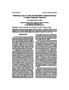
Table 1 shows the descriptive statistics of all the 25 rainfall stations. These statistics are computed from the timeseries during the period 1981-2008. This table shows the spatial variation of the daily rainfall across 25 stations within and closer to the basin. Minimum daily mean rainfall is 1.16 mm with standard deviation (SD) of 5.58 mm and maximum daily rainfall is 7.13 mm with SD of 20.35 mm. Therefore, aggregation of the 25 stations daily rainfall data by simple un-weighted average method seems inappropriate. Thus, weighted averaging technique is adopted. To compute weighted average daily rainfall, proportion of area of each station is taken as the weight with respect to the area of the whole basin. This area is computed by Thiessen Polygon. Table 1 shows the area in the second and eight columns. Its proportion as weight is presented in third and ninth columns for each station. By this method, area weighted rainfall is generated for each day of time-series of 1981-2008. The following figure (Fig. 1) shows the trend of the mean area weighted rainfall (in mm) during 1981-2008 period. Fig. (1) shows gradual increase in mean weighted daily area rainfall during the period 1981-2008 AD. This may be due to several atmospheric variables, for example sea level pressure, temperature, relative humidity, etc. Here, the study aims to develop and use the logistic regression model to forecast the rainfall pattern by use of a binary variable that represents the rainfall occurrence in a particular day. It is assumed that this variable is influenced by several atmospheric predictor variables. These variables are obtained from various general circulation models but their source is limited to the NCEP/NCAR reanalysis data. 2.3.1. Predictors In climate change impact studies, the usual practice is to use potential predictor variables with their realizations simulated by various climate models like General Circulation Models (GCMs) that project global climatic variables under different emission scenarios with coarse resolutions [15]. Thus, their direct use is not suitable for
assessment of impact of climate change at local level. The large-scale data of predictor variables are also available as National Centers for Environmental Prediction (NCEP) reanalysis products [16]. NCEP reanalysis data are available as daily or monthly mean for period 1948 to 2013, with spatial resolution of 2.50× 2.50. Appropriate selection of the climatic variables is guided by the most important skills in a downscaling process [5-6]. Moreover, the choice of predictors could vary from place to place with respect to nature of GCMs outputs and a predictand chosen. However, the following three criteria are considered in the selection process [17]. They are: (1) Predictors are variables of relevance and can be realistically modeled by GCM or Reanalysis data; (2) the transfer function is valid also under altered climatic conditions. But this assumption in principle cannot be proven in advance. The observational record should cover a wide range of variations in the past, ideally with content of all expected future realizations of the predictors; (3) the predictors have the physical relationship with a predictand chosen. Under these criteria, some predictor variables are selected and they are Sea Level Pressure (SLP) at 850 hPa, Geopotential Height (GPH) at 850 hPa, Air Surface Temperature (AST) in Kelvin, Ucomponent of wind (U-W) at 850 hPa, V-component of wind (V-W) at 850 hPa, and Precipitable Water (PW) at 850 hPa. As the present study focuses on only to build a predictive model, only NCEP/NCAR reanalysis data are taken into consideration for the study. Before building a logistic regression model, descriptive analysis of spatial-temporal distribution pattern of all the seven potential predictor variables were analyzed one by one with help of graphs which plotted their 9 gridded mean values against year. In Fig. (2), first upper three line graphs present that there is no significant difference on average GPH across three longitudinal positions 82.50E, 85.00E and 87.50E at the same latitudinal position 250N. Similarly, we see that there is no significant difference in average GPH across three longitudinal positions 82.50E, 85.00E and 87.50E at the same
12
The Open Atmospheric Science Journal, 2015, Volume 9
Shrestha et al.
7
6
Mean area weighted daily rainfall in mm
5
4
3
2
1
2008
2007
2006
2005
2004
2003
2002
2001
2000
1999
1998
1997
1996
Year
1995
1994
1993
1992
1991
1990
1989
1988
1987
1986
1985
1984
1983
1982
1981
0
Fig. (1). Average daily area weighted rainfall during 1981-2008.
latitudinal positions 27.50N and 300N, respectively. But there seems a larger gap between the first set of three lines and the second and third set of three lines. It means that there is a significant difference in average GPH between the positions at 82.50E and, at 85.00E and 87.50E at three different latitudinal positions 250N, 27.50N and 300N. However, this variation is not so much apparent between latitudinal positions 27.50N and 300N. Thus, it can be concluded that on average GPH increases latitudinal-wise from south to north within northern hemisphere with increasing variations. In addition, there is a gradual upward trend across all the nine lines during 1981-2008 periods with distinct oscillations. Thus, it shows that on average there is both spatial and temporal variation in the GPH. Although there is a positive correlation between GPH and rainfall at basin level found in the past studies, it may or may not be possible to infer that the rainfall increases from south to north within northern hemisphere because GPH is a large-scale output with coarse in nature at the basin scale. However, such relation may appear in the result of a model formulation. Similarly, in
Fig. (3), relative humidity shows somewhat similar behavior as shown by GPH in Fig. (2) but their oscillation pattern seems less in amplitude. In addition, there is a very slow upward trend across all nine lines for the period of 19812008 year with distinct oscillations. In Figs. (4, 5), both Sea Level Pressure and Precipitable Water show similar behavior as shown by GPH in Fig. (2). But, their oscillation seems less in amplitude too. In addition, there is a very slow upward trend across all nine lines during 1981-2008 periods with distinct oscillations. In Fig. (6), UW shows less spatial variation for the first few years but the variation seems gradually increasing onwards. In Fig. (7), VW shows smaller variation for the last few years. It is clear that two U-W and V-W have different erratic behavior in their spatial distribution. However, in Fig. (8), AST shows smooth variation without any erratic oscillation. Therefore, all the seven predictor variables may have some different effects on the rainfall pattern in the study region.
Logistic Model as a Statistical Downscaling Approach
The Open Atmospheric Science Journal, 2015, Volume 9
1530
Mean geopotential height in meter at level 850 hpa
1520
1510
1500
1490
1480
GPH_Lon82.5_Lat_25 GPH_Lon85_Lat_25 GPH_Lon87.5_Lat_25 GPH_Lon82.5_Lat_27.5 GPH_Lon85_Lat_27.5 GPH_Lon87.5_Lat_27.5 GPH_Lon82.5_Lat_30 GPH_Lon85_Lat_30 GPH_Lon87.5_Lat_30
1470
1460
1450
1440
2007
2005
2003
2001
1999
1997
1995
1993
1991
1989
1987
1985
1983
1981
1979
1977
1975
1973
1971
1430
Year
Fig. (2). Spatial and temporal distribution of GPH at 850 hPa. 100
Mean relative humidity in % at level 850 hpa
90
80
70
60
50
40
RH_Lon82.5_Lat25 RH_Lon85_Lat25 RH_Lon87.5_Lat25 RH_Lon82.5_Lat27.5 RH_Lon85_Lat27.5 RH_Lon87.5_Lat27.5 RH_Lon82.5_Lat30 RH_Lon85_Lat30 RH_Lon87.5_Lat30
30
20
10
Fig. (3). Spatial and temporal distribution of RH at 850 hPa.
2007
2005
2003
2001
1999
1997
1995
1993
1991
1989
1987
1985
1983
1981
1979
1977
1975
1973
1971
0
13
14
The Open Atmospheric Science Journal, 2015, Volume 9
Shrestha et al.
1030
Mean sea level pressire in pascal at level 850 hpa
1025
1020
1015
SLP_Lon82.5_Lat_25 SLP_Lon85_Lat_25 SLP_Lon87.5_Lat_25 SLP_Lon82.5_Lat_27.5 SLP_Lon85_Lat_27.5 SLP_Lon87.5_Lat_27.5 SLP_Lon82.5_Lat_30 SLP_Lon85_Lat_30 SLP_Lon87.5_Lat_30
1010
1005
1000
2007
2005
2003
2001
1999
1997
1995
1993
1991
1989
1987
1985
1983
1981
1979
1977
1975
1973
1971
995
Year
Fig. (4). Spatial and temporal distribution of SLP at 850 hPa. 45
40
35
30
PW_Lon82.5_Lat_25
25
PW_Lon85_Lat_25 PW_Lon87.5_Lat_25 PW_Lon82.5_Lat_27.5 PW_Lon85_Lat_27.5
20
PW_Lon87.5_Lat_27.5 PW_Lon82.5_Lat_30 PW_Lon85_Lat_30 PW_Lon87.5_Lat_30
15
10
5
Year
Fig. (5). Spatial and temporal distribution of PW at 850 hPa.
2007
2005
2003
2001
1999
1997
1995
1993
1991
1989
1987
1985
1983
1981
1979
1977
1975
1973
1971
0
Logistic Model as a Statistical Downscaling Approach
The Open Atmospheric Science Journal, 2015, Volume 9
6
UW_Lon82.5_Lat25 UW_Lon85_Lat25 UW_Lon87.5_Lat25 UW_Lon82.5_Lat27.5 UW_Lon85_Lat27.5 UW_Lon87.5_Lat27.5 UW_Lon82.5_Lat30 UW_Lon85_Lat30 UW_Lon87.5_Lat30
Mean U-Wind in meter per second at level 850 hpa
5
4
3
2
1
2007
2005
2003
2001
1999
1997
1995
1993
1991
1989
1987
1985
1983
1981
1979
1977
1975
1973
1971
0
Year
Fig. (6). Spatial and temporal distribution of U-Wind at 850 hPa.
Mean v-wind in meter per second at level 850 hpa
4
VW_Lon82.5_Lat25 VW_Lon85_Lat25 VW_Lon87.5_Lat25 VW_Lon82.5_Lat27.5 VW_Lon85_Lat27.5 VW_Lon87.5_Lat27.5 VW_Lon82.5_Lat30 VW_Lon85_Lat30 VW_Lon87.5_Lat30
3
2
1
0
-1
-2
-3 1971 1974 1977 1980 1983 1986 1989 1992 1995 1998 2001 2004 2007 Year
Fig. (7). Spatial and temporal distribution of V-Wind at 850 hPa.
15
16
The Open Atmospheric Science Journal, 2015, Volume 9
Shrestha et al.
310
300
Mean air surface temperature in kelvin
290
280
270
AST_Lon82.5_Lat25 AST_Lon85_Lat25 AST_Lon87.5_Lat25 AST_Lon82.5_Lat27.5 AST_Lon85_Lat27.5 AST_Lon87.5_Lat27.5 AST_Lon82.5_Lat30 AST_Lon85_Lat30 AST_Lon87.5_Lat30
260
250
2007
2005
2003
2001
1999
1997
1995
1993
1991
1989
1987
1985
1983
1981
1979
1977
1975
1973
1971
240
Fig. (8). Spatial and temporal distribution of AST at 850 hPa.
2.3.2. Correlation Between Daily Area Weighted Rainfall and Each of 9 Gridded Predictors
correlation are not fixed across 9 grids. Observed correlations do vary for different predictors across 9 grids and are statistically significant too. However, the correlations are relatively higher for Precipitable Water, Relative Humidity, Geopotential Height and Sea Level Pressure in all of the 9 grids but relatively lower for the remaining predictors and weakest for U-wind in all grids. Spatially, there are small variations in correlation between grids for most of the predictors except for Air Surface Temperature and V-Wind.
Pearson correlation analysis was performed to examine whether there is a significant correlation between daily area weighted rainfall and a predictor in 9 grid observations. The results (Table 2) reveal correlations between daily area weighted rainfall (in mm) and each of seven predictor variables for the analysis data (sample size=7305). Correlation coefficient seems changing from one grid to other for every predictor. The strength and direction of the Table 2.
Correlation table.
Predictor
Lon82.5_ Lat_25 (G1)
Lon85_ Lat_25 (G2)
Lon87.5_ Lat_25 (G3)
Lon82.5_ Lat_27.5 (G4)
Lon85_Lat_ 27.5 (G5)
Lon87.5_ Lat_27.5 (G6)
Lon82.5_ Lat_30 (G7)
Lon85_ Lat_30 (G8)
Lon87.5_ Lat_30 (G9)
Geopotential Height (mm)
-.420**
-.419**
-.410**
-.442**
-.431**
-.415**
-.435**
-.413**
-.389**
Relative humidity (%)
.394**
.416**
.414**
.372**
.362**
.376**
.391**
.461**
.469**
Sea Level Pressure (Pa or Mbar)
-.400**
-.408**
-.406**
-.415**
-.417**
-.417**
-.440**
-.444**
-.428**
Precipitable Water (mm)
.484**
.495**
.498**
.493**
.517**
.528**
.467**
.493**
.512**
Air Surface Temperature (0 K)
.147**
.169**
.214**
.305**
.376**
.419**
.441**
.449**
.448**
U-Wind (ms-1)
.054**
-.060**
-.106**
.144**
.017
-.061**
.119**
-.027*
-.131**
**
**
**
**
**
**
**
.237**
-1
V-Wind (ms ) *
.175
.265
.352
.303
**
.381
.416
.119
.193
Correlation is significant at the 0.05 level (2-tailed); **Correlation is significant at the 0.01 level (2-tailed); Units of measurements are provided in brackets.
Logistic Model as a Statistical Downscaling Approach
The Open Atmospheric Science Journal, 2015, Volume 9
17
2.3.3. Principal Component Analysis (PCA)
•
Principal component analysis (PCA) is performed for each of predictors GPH, RH, SLP, PW, AST, U-W and V-W based upon analysis period 1981-2008 spanning 7305 days. A number of components are determined by the eigenvalue 1 or more as a threshold value under the varimax rotation method. The results (Table 3) are as follows.
U-W has 2 components represented by U-WIND_1 (UW1) with higher loadings (>0.69) for the first 6 gridded areas (UW1_G1-UW1_G6) and U-WIND_2 (UW2) with higher loadings (>0.85) for the last 3 gridded areas (UW2_G7-UW2_G9), both together explaining 90.15 % of the total variation.
•
V-W has 3 components represented by V-WIND_1 (VW1) with higher loadings (>0.80) to the last 3 gridded areas (VW1_G7-VW1_G9), V-WIND_2 (VW2) with higher loadings (>0.68) to 3 gridded areas (VW2_G3, VW2_G5-VW2_G6) and VWIND_3 (VW3) with higher loadings (>0.71) to 3 gridded areas (VW3_G1-VW3_G2 and VW3_G4), all together explaining 95.34 % of the total variation. In PCA each component for any predictor has some distinct spatial characteristics. Loadings in extracted components obtained from analysis period are used for validation period for all the predictors. Results of PCA with loadings are shown in Table 3.
•
GPH has 1 component represented by Geopotential Height_1 (GPH1) with all 9 loadings higher than 0.94 and explains94.98 % of the total variation.
•
RH has 2 extracted components represented by Relative Humidity_1 (RH1) which has higher loadings for the first 6 gridded areas (RH1_G1 RH1_G6) of loadings (> 0.65) and Relative Humidity_2 (RH2) which has higher loadings (> 0.70) for the last 3 gridded areas (RH2_G7-RH2_G9), both together explaining 85.24 % of the total variation.
•
SLP has 1 component, represented by Sea Level Pressure_1 (SLP1) with all 9 gridded items of loadings higher than0.93 and explains 93.53 % of the total variation.
2.4. Methods
•
•
PW has also 1 component represented by Precipitable Water_1 (PW1) with all 9 gridded items of loadings higher than 0.95 and explains 94.08 % of the total variation.
•
AST has 2 components represented by Air Surface Temperature_1 (AST1) with higher loadings (>0.80) for the last 5 gridded areas (AST1_G5-AST1_G9) and Air Surface Temperature_2 (AST2) with higher loadings (> 0.74) for the first 4 gridded areas (AST2_G1-AST2_G4), both together explaining 96.95 % of the total variation.
Table 3.
Statistical downscaling model is based on logistic regression model which shows a functional relationship between a binary response and a pool of predictors which accounts seven atmospheric variables as defined above. The daily time-series is available for 1981-2008 is split into two parts, first part for the purpose of analysis spanning 20 years (1981-2000) and second part for validation of the fitted model spanning 8 years (2001-2008) [18]. The logistic regression model is applied by employing following two important criteria: a) for a given pool of predictors, the objective is to estimate the probability of rainfall occurrence, and b) to assess the magnitude of the effects of atmospheric variable on the rainfall occurrence by odds ratio (OR). Here, a response variable, Yi is defined as a day with rainfall
Spatial grid loadings of predictors.
Predictor
Lon82.5_ Lat_25 (G1)
Lon85_ Lat_25 (G2)
Lon87.5_ Lat_25 (G3)
Lon82.5_ Lat_27.5 (G4)
Lon85_ Lat_27.5 (G5)
Lon87.5_ Lat_27.5 (G6)
Lon82.5_ Lat_30 (G7)
Lon85_ Lat_30 (G8)
Lon87.5_ Lat_30 (G9)
GPH1
0.961
0.973
0.975
0.991
0.997
0.989
0.977
0.964
0.944
RH1
0.863
0.898
0.853
0.883
0.857
0.656
0.482
0.313
0.284
RH2
0.347
0.350
0.338
0.291
0.311
0.508
0.730
0.936
0.918
SLP1
0.969
0.975
0.977
0.985
0.987
0.973
0.953
0.952
0.933
PW1
0.971
0.974
0.961
0.985
0.994
0.979
0.955
0.957
0.952
AST1
0.291
0.337
0.421
0.643
0.804
0.883
0.923
0.944
0.943
AST2
0.934
0.937
0.854
0.741
0.573
0.438
0.361
0.322
0.314
UW1
0.952
0.964
0.896
0.793
0.791
0.696
0.330
0.242
0.146
UW2
0.114
0.193
0.251
0.442
0.581
0.621
0.856
0.964
0.925
VW1
0.027
-0.008
-0.024
0.372
0.441
0.402
0.808
0.965
0.896
VW2
0.232
0.674
0.906
0.321
0.688
0.897
-0.123
0.151
0.361
VW3
0.944
0.712
0.332
0.847
0.543
0.125
0.498
0.156
-0.116
GPH1 = 0.961(GPH1_G1) + 0.973 (GPH1_G2) + 0.975 (GPH1_G3) + 0.991(GPH1_G4) + 0.997(GPH1_G5) + 0.989(GPH1_G6) + 0.977(GPH1_G7) + 0.964(GPH1_G8) + 0.944(GPH1_G9) and so on.
18
The Open Atmospheric Science Journal, 2015, Volume 9
Shrestha et al.
occurrence if the area weighted rainfall is more than 1 mm per day in the study area. Consequently, Yi assumes two possible values 1 and 0 with probability of rainfall occurrence (pi) (for wet day), and 1- pi, probability of no rainfall (for dry day), respectively. Then, odds of success is expressed as ⎛ pi ⎞ which is the ratio of the probability of ⎜ ⎟ ⎝ 1 − pi ⎠
success (rainfall occurrence) to the probability of failure (rainfall non-occurrence). The logistic regression model [19] is expressed: k ⎛ p ⎞ Log ⎜ i ⎟ = β0 + ∑ βi xi i =1 ⎝ 1 − pi ⎠
(1)
pi can be computed by:
pi =
e
β0 +
1+ e
k
∑ βi xi i =1
β0 +
k
∑ βi xi i =1
1
= 1+ e
k ⎛ ⎞ −⎜ β 0 + βi xi ⎟ ⎜ ⎟ i =1 ⎝ ⎠
(2)
∑
where β0 and β i (coefficient attached with the ith regressor) are the unknown model parameters to be estimated from observed data and xi is ith regressor of the model. Odds ratio: Odds ratio (OR) plays an important role in logistic regression. For multiple predictors, OR associated with the regressor xj can be interpreted as the increase (or decrease) in probability of success associated with unit increase in the predictor assuming values of the remaining predictors are constant. The computational formula of OR associated with xi is:
model. The ROC curve is obtained by plotting sensitivity of all values against its specificity. 3. RESULTS In the formulation of logistic regression model, the forward and backward model selection methods produced six different logistic models. But the sixth model produced by them were the same. The predictors included in the model were Geopotential Height_1, Relative Humidity_1, Relative Humidity_2, Sea Level Pressure_1, Precipitable Water_1, Air Surface Temperature_1 and V-Wind_2 with all significant coefficients (p