regions with acceptable rock populations and to support Monte Carlo landing ... (2008), Mars Exploration Program 2007 Phoenix landing site selection and ...
JOURNAL OF GEOPHYSICAL RESEARCH, VOL. 113, E00A03, doi:10.1029/2007JE003021, 2008
Mars Exploration Program 2007 Phoenix landing site selection and characteristics R. Arvidson,1 D. Adams,2 G. Bonfiglio,2 P. Christensen,3 S. Cull,1 M. Golombek,2 J. Guinn,2 E. Guinness,1 T. Heet,1 R. Kirk,4 A. Knudson,1 M. Malin,5 M. Mellon,6 A. McEwen,7 A. Mushkin,8 T. Parker,2 F. Seelos IV,9 K. Seelos,9 P. Smith,7 D. Spencer,2 T. Stein,1 and L. Tamppari2 Received 12 October 2007; revised 10 March 2008; accepted 21 April 2008; published 19 June 2008.
[1] To ensure a successful touchdown and subsequent surface operations, the Mars
Exploration Program 2007 Phoenix Lander must land within 65° to 72° north latitude, at an elevation less than 3.5 km. The landing site must have relatively low wind velocities and rock and slope distributions similar to or more benign than those found at the Viking Lander 2 site. Also, the site must have a soil cover of at least several centimeters over ice or icy soil to meet science objectives of evaluating the environmental and habitability implications of past and current near-polar environments. The most challenging aspects of site selection were the extensive rock fields associated with crater rims and ejecta deposits and the centers of polygons associated with patterned ground. An extensive acquisition campaign of Odyssey Thermal Emission Imaging Spectrometer predawn thermal IR images, together with �0.31 m/pixel Mars Reconnaissance Orbiter High Resolution Imaging Science Experiment images was implemented to find regions with acceptable rock populations and to support Monte Carlo landing simulations. The chosen site is located at 68.16° north latitude, 233.35° east longitude (areocentric), within a �50 km wide (N-S) by �300 km long (E-W) valley of relatively rock-free plains. Surfaces within the eastern portion of the valley are differentially eroded ejecta deposits from the relatively recent �10-km-wide Heimdall crater and have fewer rocks than plains on the western portion of the valley. All surfaces exhibit polygonal ground, which is associated with fracture of icy soils, and are predicted to have only several centimeters of poorly sorted basaltic sand and dust over icy soil deposits. Citation: Arvidson, R., et al. (2008), Mars Exploration Program 2007 Phoenix landing site selection and characteristics, J. Geophys. Res., 113, E00A03, doi:10.1029/2007JE003021.
1. Introduction [2] The Mars Exploration Program 2007 Phoenix Lander will touch down at a high northern latitude site and sample the soil cover and icy soil, focusing on determining the nature of 1
Department of Earth and Planetary Sciences, Washington University, St. Louis, Missouri, USA. 2 Jet Propulsion Laboratory, California Institute of Technology, Pasadena, California, USA. 3 Department of Geological Sciences, Arizona State University, Tempe, Arizona, USA. 4 U.S. Geological Survey, Flagstaff, Arizona, USA. 5 Malin Space Science Systems, San Diego, California, USA. 6 Laboratory for Atmospheric and Space Physics, Department of Astrophysical and Planetary Sciences, University of Colorado, Boulder, Colorado, USA. 7 Department of Planetary Sciences, University of Arizona, Tucson, Arizona, USA. 8 Department of Earth and Space Sciences, University of Washington, Seattle, Washington, USA. 9 Applied Physics Laboratory, Johns Hopkins University, Baltimore, Maryland, USA. Copyright 2008 by the American Geophysical Union. 0148-0227/08/2007JE003021
the deposits using its Thermal Evolved Gas Analyzer (TEGA) (W. V. Boynton et al., The Thermal and Evolved-Gas Analyzer on the Phoenix Mars Lander, manuscript in preparation, 2008) and Microscopy Electrochemistry and Conductivity Analyzer (MECA) [Smith et al., 2008; M. H. Hecht et al., Microscopy capabilities of the Microscopy, Electrochemistry, and Conductivity Analyzer, submitted to Journal of Geophysical Research, 2008; S. P. Kounaves et al., The 2007 Phoenix Mars Scout Lander MECA Wet Chemistry Laboratory, submitted to Journal of Geophysical Research, 2008] (Figure 1). TEGA will search for organic compounds that may have been preserved under the very cold conditions inherent to these latitudes, allowing characterization of the extent to which shallow subsurface deposits in the near-polar regions were or are habitable. Other important measurements will focus on (1) analysis of the geomorphology of the landing site using the mast-based Stereo Surface Imaging (SSI) system and Robotic Arm Camera (RAC) (M. T. Lemmon et al., The Phoenix Surface Stereo Imager Investigation, manuscript in preparation, 2008; H. U. Keller et al., The Phoenix Robotic Arm Camera, manuscript in preparation, 2008), (2) determination of soil and icy soil mechanical properties using the
E00A03
1 of 14
E00A03
ARVIDSON ET AL.: PHOENIX LANDING SITE SELECTION
E00A03
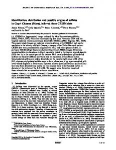
Figure 1. Artist’s view of the Phoenix Lander with legs deployed and thrusters on just before landing. This phase of entry, descent, and landing illustrates the need to land in an area without many tall rocks. The distance from the bottom of the lander to the uncompressed footpads is �0.4 m. imaging systems combined with the Robotic Arm (RA) and associated Icy Soil Acquisition Device (ISAD) [Bonitz et al., 2008], (3) determination of icy soil thermal and electrical properties using the Thermal and Electrical Conductivity Probe (TECP) (A. P. Zent et al., The Thermal Electrical Conductivity Probe for Phoenix, submitted to Journal of Geophysical Research, 2008), and (4) characterization of the atmosphere by conducting imaging, meteorological, and lidar observations [e.g., Taylor et al., 2008; Whiteway et al., 2008; Lemmon et al., manuscript in preparation, 2008]. [3] Key to meeting mission objectives is the selection of a landing site that has a high probability of successful touchdown and subsequent surface operations, combined with a high probability of finding soil and accessible icy soil deposits. This paper describes the site requirements, the processes associated with site selection, and the characteristics of the chosen site. Detailed descriptions of the geomorphic and geologic settings for the key candidate sites are presented
by Seelos et al. [2008], determination of the depth of soil cover over ice as derived from gamma ray, neutron, and emission spectroscopy is covered in detail by Mellon et al. [2008], a detailed summary of rock size-frequency distributions in the northern plains of Mars is presented by Golombek et al. [2008], and estimations of slopes are given by Kirk et al. [2008]. Finally, a summary of mesoscale atmospheric circulation models for the Phoenix latitude zone and specific candidate landing sites is presented by Tamppari et al. [2008].
2. Entry, Descent, Landing, and Site Requirements [4] The Phoenix spacecraft will enter the Mars atmosphere on a direct trajectory, with an atmosphere-relative entry velocity of 5.5 km/s. During hypersonic flight through the upper atmosphere, Phoenix will utilize an aeroshell to withstand heating rates of up to 44 W/cm2. A Viking-
2 of 14
ARVIDSON ET AL.: PHOENIX LANDING SITE SELECTION
E00A03
E00A03
Table 1. Landing Site Requirements Requirement
Rationale
Latitude zone between 65° and 72° north
Ensure enough solar power to conduct primary and extended missions for a latitude zone that is likely to have icy soil accessible for sampling by the robotic arm Ensure high enough atmospheric pressure to enable entry, descent, and landing with high probability of success Ensure high probability of landing without hitting a rock or not being able to deploy the solar arrays because of nearby rocks
Elevation less than 3.5 km relative to MOLA-defined reference surface Rock size-frequency distribution equal to or less dense than that found at Viking Lander 2 (anchor site) Wind velocities and wind shear magnitudes relatively benign [Tamppari et al., 2008] Slope distributions from 1 m to 10 km consistent with Viking Lander 2 site and final lander tilt less than 16° Thin (