Multi-Objective Optimization for Resilient Airline Networks Using Socioeconomic-Environmental Data Hidefumi Sawai
Aki-Hiro Sato
International Affairs Department Department of Applied Mathematics and Physics National Institute of Information and Communications Technology Graduate School of Informatics, Kyoto University 4-2-1, Nukui-Kitamachi, Koganei, Tokyo 184-8795 Japan Honmachi, Yoshida, Sakyo-ku, Kyoto 606-8501 Japan Email:
[email protected] Email:
[email protected] Data linkage is a useful method to obtain the data. We use geographical information of events as a key element to connect data from different data sources.
Abstract—This paper proposes a multi-objective optimization method for a Japanese domestic airline network using socioeconomic-environmental data obtained from Japanese governmental bureaus and NOAA Tsunami Data and Information. Japanese domestic air transportation information is extracted to construct an airline network constituting of airports and flights. When we define three kinds of metrics such as Risk (R), Economy (E) and Convenience (C) for an airline network based on several statistics and evaluate them, we find that there exists a tradeoff relationship between these metrics. It is shown that multiobjective optimization is possible to recover the airline network by decreasing the Risk (R) metric while simultaneously increasing the Economy (E) and Convenience (C) metrics, even in a severe situation such that some airports are damaged by tsunamis and their associated flights at the airports are all cancelled.
I.
A. Risk index Swiss RE proposes a global ranking for cities under threat from natural disasters [4]. Munich RE proposes a risk indicator as a multiplication among hazard, vulnerability, and exposed value [5]. Hazard represents the probability of natural disasters such as earthquakes, storms, floods, tsunami, and so forth; vulnerability shows the structure of buildings, residential density, and levels of security measures; and the exposed value expresses an economic value unprotected from natural disasters.
I NTRODUCTION
B. Physical exposure
Recent advanced information and communication technology makes it possible to tackle challenges by means of data-oriented methodology, which is both inductive and cyber-enabled strategy. This framework is called data-centric sciences, which are recently emerging in various fields of sciences. This study proposes a multi-objective optimization method using geographical risk, economic and convenience metrics for airline networks based on socioeconomicenvironmental data. The physical exposure of Japan in terms of tsunami run-up events is computed based upon 1-km grid square statistics from the population census of the Japanese Statistics Bureau of the Ministry of Internal Affairs and Communications in Japan [1]; 1-km grid square on national land numerical information downloaded from the Japanese National and Regional Policy Bureau of the Ministry of Land, Infrastructure, Transport, and Tourism in Japan [2]; and tsunami run-up catalog data downloaded from NOAA Tsunami Data and Information [3].
In general, there is an assumption of multiplication in an estimation of risk. In the case of risk of loss of lives, risk R represents an expected value of loss of lives defined as R = F · V ul · P op = P hExp · V ul,
(1)
where F [event/year] (hazard) represents frequency of a natural disaster, V ul shows vulnerability taking a value ranging from 0 to 1, and P op [exposed persons/year] expresses population exposed by the natural disaster. In particular, the multiplication of frequency of a natural disaster F by the population exposed by the natural disaster P op: P hExp = F · P op
(2)
is called physical exposure, which corresponds to an expected loss under the worst of conditions (V ul = 1) [6]. More generally, assuming n kinds of disasters i (i = 1, . . . , n), we extend the definition of the physical exposure as
The Japanese domestic air transportation information is further extracted as a network consisting of airports and flights. Using an exposed value as a sum of passengers in flights landing at and taking off from each airport, we compute values of physical exposure as risk, economic and convenience metrics for 86 Japanese airports respectively in terms of tsunami run-up events, the number of passengers and several network parameters by using the proposed procedure. Therefore, we focus on tsunami damages as one of the most significant natural disasters, which cause a long down period, by estimating physical exposure using tsunami catalog data.
P hExp(n) =
n X
Fi · P opi ,
(3)
i=1
where Fi represents the frequency of the i-th disaster [event/year], and P opi population exposed by the i-th disaster. Even though the physical exposure P hExp is high, we can reduce the risk R by taking measures against the disaster. However, because potential risk depends on place and expresses as a function in terms of location, we need to detect the place where we change the structure. This corresponds to estimating physical exposure P hExp in space. 1
1|Page
TABLE I. M AIN AIRPORTS IN JAPAN : T HE YEARLY NUMBER OF FLIGHTS TAKING OFF FROM AND LANDING AT MAIN JAPANESE DOMESTIC AIRPORTS IN 2012.
C. Estimation of Frequency of Hazard F The frequency of hazard F [event/year] was defined as the event’s frequency per year based on the Tsunami data in the last 1,000 years provided by NOAA. However, as Tsunami events rarely happen, a problem would occur such that the frequency for never observed Tsunami data so far would be zero even if we use data in a very long period. To avoid this problem, it is possible for us to estimate the occurrence probability distribution for excluded rarely happened events’ data by extrapolating from the probability distribution using good fitted data. For the estimation of Tsunami run-up events, we presumed the generalized Pareto distribution (GDB): Pr(X ≥ x) = (1 +
ξ(x − µ) − 1ξ ) , β
(4)
(5)
ˆ µ where ξ, ˆ, βˆ are the maximum likelihood estimators for ξ, µ and β, respectively [7]. II.
P HYSICAL
#Flights taking off
#Flights landing
#Passengers taking off
#Passengers landing
Peripheral population
(1) Haneda (2) New Chitose (3) Naha (4) Fukuoka (5) Itami/Osaka (6) Kansai (7) Chubu (8) Kagoshima (9) Narita (10) Kumamoto
172,120 57,204 52,546 61,184 61,352 18,719 25,416 27,188 17,031 13,395
171,991 57,192 52,553 61,195 61,260 18,499 25,389 27,138 17,078 13,427
27,460,790 7,801,648 6,770,706 6,792,912 6,176,988 2,278,527 2,234,405 2,183,825 1,532,064 1,347,364
27,472,147 7,663,256 6,769,307 6,730,288 6,057,966 2,311,817 2,244,387 2,186,831 1,582,186 1,335,353
17,853,073 445,365 1,134,699 2,932,290 10,548,426 3,113,893 2,679,466 570,867 2,072,684 1,217,513
TABLE II. A IRPORTS WITH THE PHYSICAL EXPOSURE VALUE P hExp[7] OF MORE THAN 100 [ PASSENGER / YEAR ] IN JAPAN (d = 30km)
where ξ is a shape parameter, β is a scale parameter and µ is a location parameter. When the total number of data within a radius of d(km) is Nd with an observation period of T and an elevation of H(c) in the location of c, the occurrence probability F (c) of Tsunami can be obtained as follows: ˆ Nd ξ(H(c) −µ ˆ) − 1ξˆ Nd F (c) = Pr(X ≥ H(c)) = (1 + ) , T T βˆ
(Rank) Airport
EXPOSURE OF JAPAN
A. Analysis of Hazard in Japan
Airport
Altitude(m)
F
#Passengers
P hExp
Peripheral population
Haneda Naha Sendai Chubu Kochi Saga Kansai Nagasaki Kobe Itami/Osaka Tokushima Oita Ishigaki
10.668 3.6576 4.572 4.572 12.8016 1.8288 7.9248 4.572 6.7056 15.240 7.9248 5.7912 28.3464
0.000299 0.000376 0.00164 0.000373 0.000743 0.00199 0.0000903 0.000160 0.000704 0.000244 0.000280 0.000156 0.000134
54,932,937 13,540,013 2,383,941 4,478,792 1,151,423 293,463 4,590,344 2,448,757 2,410,847 12,234,954 818,183 1,361,626 1,522,507
16,411.84 5,091.82 3,912.84 1,669.45 856.03 582.99 414.69 391.64 293.74 277.18 229.49 212.28 204.23
17,853,073 1,134,699 1,603,150 2,679,466 544,528 1,286,956 3,113,893 967,350 7,714,653 10,548,42 699,312 329,736 48,088
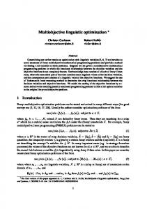
of an airport exposed to tsunami run-up events is the total number of passengers at the airport in which airplanes took off and landed. We define that the number of passengers on airplanes that land at airport i per year is y (in) (i) [passenger/year] and the number of passengers on airplanes that take off from airport i per year is y (out) (i) [passenger/year]. Then, we can estimate the number of passengers on airplanes that land at and take off from airport i per year by an equation, P op(i) = (y (in) (i) + y (out) (i)) [passenger/year]. Therefore, we can estimate physical exposure of the airport i as Fig. 1. A hazard map of Japan: this figure shows earthquakes (brown triangles), tsunamis (pink squares), volcanic eruptions (red triangles) and major cities (blue circles) in Japan.
P hExp(i) = P op(i) · F (i).
(6)
B. Analysis on Japanese Domestic Airline Networks The seacoast of the Pacific Ocean in East Japan was damaged badly by the tsunami from the Great East Japan Earthquake on 11 March 2011. Many people still remember the damage of the tsunami. In fact, it took one month to repair Sendai Airport from tsunami damage. A hazard map of Japan, where earthquakes (brown triangles), tsunamis (pink squares), volcanic eruptions (red triangles) and major cities (blue circles) in Japan, is shown in Figure 1. Are there any risks of tsunami damage in other Japanese airports? How do we estimate values of physical exposure in Japanese air transportation network?
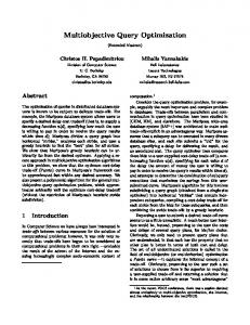
A current Japanese domestic airline network is shown in Figure 2. The numbers of available airports and flight routes are 86 and 462, respectively. This figure is drawn based on information of the flights from the yearly statistics of Japanese air transportation in 2012. We can see clearly hub airports, Haneda Airport, New Chitose Airport, Naha Airport, Fukuoka Airport, Itami Airport and so on. According to the flight data in Table I, the top ten ranking airports (the main airports) have relatively a large number of flights as well as the number of passengers taking off and landing. The number of passengers on airplanes that land at and take off from Haneda Airport is the highest in Japan – 54,932,937 passengers in the year.
We estimate physical exposure in these airports by asking the above questions. First, we assume that the economic value 2
2|Page
TABLE IV.
Fig. 2.
value
(3)
(4)
(5)
(6)
(7)
(8)
(9)
(10)
×
×
△
△ △
△ △
×
△
△ △
×
△
△
×
×
△
×
△ × -
E VALUATION OF A IRLINE N ETWORKS U SING S OCIOECONOMIC -E NVIRONMENTAL DATA
In this study, we redefine the metric of economy E by reflecting the peripheral population around each airport, and try to improve the convergence property of three metrics by integrating the evolutionary method with an optimization method based on a gradient descent and ascent approach while maintaining the total numbers of flights and passengers as constant as possible.
A NALYSIS OF CURRENT JAPANESE DOMESTIC AIRLINE NETWORK (2012)
86 462 5.37209 1399.34 km 2.57811 2.64131 0.469923 769,717 84,939,288 357.875 3,271.23 3,994.79
(2)
△
△
Evaluation of airline networks in terms of safety, economy and convenience is important because our flights are easily affected by natural disasters and accidents. It is possible for us to increase not only the convenience of the airline networks by reorganizing the airline networks [8], but also the robustness and resilience against such natural disasters and accidents [9]. Global airline networks have been evaluated using 100 major airports in the world with their longitudes, latitudes, population and world ranking data, etc. [10]. Also, a geographical risk assessment has been performed using socioeconomicenvironmental data [7]. Furthermore, we have evaluated a current Japanese domestic air transportation network with oneday flight information using three kinds of metrics, risk (R), economy (E) and convenience (C), and then tried to improve the three metrics simultaneously using an evolutionary method [11].
We analyzed the airline network in Figure 2 using several network parameters such as average degree hki, average distances L(dist) and L(step), “Small-Worldness” R(step) [8], clustering coefficient C, and the three metrics R, E and C (described in the later section), as well as the numbers of total flights F0 and passengers P0 . As a result, we got its network parameter values and metrics, as shown in Table III. The average degree hki is 5.37209 which means that there are 5.37209 different flight routes on average per airport. The average cruising distance between any pairs of airports L(dist) is 0.219764 in the unit of radius of Earth which corresponds to 1,399.34 km, and the average number of steps L(step) is 2.57811. The available flight service information between the
Available number of airports Available number of flight routes Average degree hki Average cruising distance L(dist) Average number of steps L(step) Small-Worldness R(step) Clustering coefficient C Total flights per year F0 Total passengers per year P0 Risk metric R0 Economic metric E0 Convenience metric C0
(1)
(1) Haneda (2) New Chitose (3) Naha (4) Fukuoka (5) Osaka (6) Kansai (7) Chubu (8) Kagoshima (9) Narita (10) Kumamoto
III.
We estimated the physical exposure P hExp(i)≡P op(i)F (i) at an airport i based on the generalized Pareto distribution [7]. There is dependence of physical exposure on d because the frequency F (i) depends on d. Table II shows airports whose physical exposure is more than 100 [passenger/year] (within a radius from airports: d = 30km). In this case, the physical exposure of Haneda Airport is the largest in Japan and it takes 16,411.84 [passenger/year].
Parameter/metric
Airport
land transportation is available.
Current Japanese domestic airline network.
TABLE III.
C URRENT STATUS OF MAIN AIRPORTS IN JAPAN
We notice from Figure 1 that many disasters such as earthquakes, tsunamis and volcanic eruptions happened in the last 1,000 years. A risk metric (R) corresponding to the physical exposure and other metrics related with economy (E) and convenience (C) using socioeconomic-environmental data can be defined for airline networks. An evaluation method for the current airline network and improvement of these metrics are described in the following sections. A. Definition of Risk Metric (R) We define a metric of risk R(i) for an airport i as the physical exposure P hExp(i). The total risk R for an airline network is defined as an average value of R(i) over all airports N as follows:
main airports is shown in Table IV. In this table, the mark “ ” represents the direct flight available between two airports. On the other hand, the mark “×” represents no direct flight between two airports. The mark “△” represents no direct flight between two airports because the distance between the two airports is close to each other, and a rapid and/or convenient
R(i) ≡ P hExp(i) = F (i)P op(i),
R≡
N X
R(i)/N. (7)
i=1
3
3|Page
The metric C(i, j) is proportional to the number of passengers P ass(i, j), inversely proportional to the cruising distance dist(i, j) and the number of steps l(i, j) from airport i to airport j, and finally is proportional to these combined values accumulated along the shortest path path(i, j). The metric C(i, j) means that the more number of available passengers P ass(i, j) for a flight, the shorter cruising distance dist(i, j) and the number of transits l(i, j) between airports i and j, the more convenient for passengers.
The risk metric changes according to the change in the total number of passengers both taking off and landing as well as the change in the total number of flights. If more passengers as well as flights are available at some airport with non-zero physical exposure, the risk metric R will increase accordingly because more passengers would be affected at some airport i with more risk R(i) in proportion to the number of passengers P op(i) and the frequency of hazard F (i). To minimize the value of Risk(i), it would be a good idea to decrease the number of passengers P op(i) at airport i with relatively large frequency F (i), and increase the number of passengers P op(j) at another airport j with relatively small frequency F (j).
The overall metric of convenience C is defined as a value averaged over all combination of any pairs of airports i and j: C≡
B. Definition of Economic Metric (E) The metric of economy E(i) for an airport i is defined as a relationship with the total number of passengers P op(i) both taking off and landing per year and its peripheral population P eri(i) within a distance d (km). The total metric of economy E for an airline network is an average over all airports N : P op(i) = E(i) ≡ E
≡
α
N X
C(i, j).
(10)
i,j=1,i6=j
What we should do is the decrease in the risk metric R, while simultaneously increasing the metrics of economy E and convenience C by changing the flight schedules taking off and landing at all airports. This corresponds to rewiring of the airline network in terms of the numbers of flights and passengers at all airports.
(y (in) (i) + y (out) (i)), β
Const.P op(i) P eri(i) , N X E(i)/N,
1 N (N − 1)
D. Definition of Problem
(8)
We defined three metrics, risk R, economy E and convenience C using several airline network parameters such as the physical exposure P hExp(i) and the number of passengers P op(i) taking-off and landing at airport i, its peripheral population P eri(i) around airport i, cruising distance dist(i, j) and the number of steps along the shortest path l(i, j) between airports i and j. The optimization problem can be defined to maximize both the metrics of economy E and convenience C while simultaneously minimizing the metric of risk R by varying each number of flights and passengers along each flight route from airports i to j by controlling each number of flights and passengers along each flight route l, each capacity at airport i, and the total numbers of flights F0 and passengers P0 within each allowable value as represented by each threshold T h. In this problem, the input values are the numbers of flights fl and passengers pl along each flight route l, and the output values are the three metrics, the risk R (for minimization), economy E and convenience C (for maximization) as the objective function as follows:
i=1
where y (in) (i) is the number of passengers per year landing at an airport i, and y (out) (i) is the number of passengers per year taking off at an airport i, and α and β are constant parameters to be estimated using real data. The metric of economy E(i) is considered to have some relationship with the number of passengers P op(i) at airport i and its peripheral population P eri(i) around airport i because more passengers would enhance the economic activity at the airport as well as in its peripheral cities, however, the exact relationship would be the future issue to determine using a multiple regression analysis on some other factors such as GDP at the peripheral cities around the airport, the flow of population between the airport and its peripheral cities, and so on. Whatever the definition for the metric of economy E(i) with any relationship would be, it would be possible to maximize the average value E using the gradient method described later in Section IV.
max{R−1 , E, C}
C. Definition of Convenience Metric (C) The metric of convenience C(i, j) between an airport i and an airport j can be defined as the following value: X P ass(i, j) C(i, j) ≡ Const. , (9) dist(i, j)l(i, j)
subject to ∆F ≡
lX max l=1
(11)
∆fl ≤ T hlf , ∆pl ≤ T hlp , P op(i) ≤ T hipop , fl − F0 ≤ T hF ,
∆P ≡
lX max
pl − P0 ≤ T hP ,
l=1
i = 1, 2, 3, ..., N ; l = 1, 2, 3, ..., lmax.
path(i,j)
where path(i, j): the shortest path from airport i to airport j, P ass(i, j): the total number of passengers taking off and landing per year along the shortest path path(i, j) from airport i to airport j, dist(i, j): the cruising distance from airport i to airport j, and l(i, j): the number of steps along the shortest path path(i, j) between airport i and airport j.
In addition to the change in the numbers of flights fl and passengers pl , the network’s rewiring corresponding to the change in the adjacency matrix a of the network can also be possible. IV.
M ULTI -O BJECTIVE O PTIMIZATION OF A IRLINE N ETWORKS
We propose a multi-objective optimization method for airline networks based on three stages where its flowchart is 4
4|Page
respectively. λf and λp are the constant penalties associated with the flight and passenger, respectively. We set the constant parameters in Eq.(8) as α = β = 0.5 in this study. In order to decrease the risk metric R while simultaneously increasing the metric of economy E, we define the changes E ∆flR and ∆flE in flight and the changes ∆pR l and ∆pl in passenger associated with risk R and economy E, respectively according to a gradient descent (for R) and ascent (for E) method as follows: ∆flR = −µF (l)fl , ˜ ∂E fl , ∂fl
∆flE = ηf
∆pR l = −µF (l)pl , ∆pE l = ηp
(13)
˜ ∂E pl , ∂pl
(14)
where µ is a constant, and the frequency of events F (l) is calculated at the departure airport i along a flight route l. Substituting Eq.(12) into Eq.(14), we can get the following formulas: max max X X ∂E ∂pl −2λf ( }fl , fl −F0 )−2λp ( pl −P0 ) ∂fl ∂fl l=1 l=1 (15) lX lX max max ∂f ∂E l fl −F0 ) pl −P0 )}pl . −2λf ( −2λp ( ∆pE l = ηp { ∂pl ∂pl l=1 l=1 (16) Total changes ∆fl in flight and ∆pl in passenger along a flight route l are as follows:
l
l
∆flE = ηf { Fig. 3.
Flowchart of Multi-Objective Optimization for Airline Networks
shown in Figure 3. The procedure includes (0) the preparation stage with network pre-wiring, (1) the network rewiring stage, and (2) the crossover stage among networks. Each stage is explained step by step in the following subsections.
∆fl = ∆flR + ∆flE ,
A. Preparation stage: Pre-wiring of Networks
Finally, total changes ∆f in flight and ∆p in passenger can be obtained by summing up ∆fl and ∆pl , respectively along all flight routes l as follows:
Using the socioeconomic-environmental data, the physical exposure, the number of flights, the number of passengers taking off and landing are registered in advance before the operation of optimization. The preparation stage may include pre-wiring of the links between the top main airports shown in Table IV: for examples, the links (flights) between (2)New Chitose Airport and (8)Kagoshima Airport, between (2)New Chitose Airport and (10)Kumamoto Airport, between (6)Kansai Airport and (10)Kumamoto Airport, and between (9)Narita Airport and (10)Kumamoto Airport, and so on. This new generation of links between the main airports may be expected to increase the metrics of economy E and convenience C, and contribute to the decrease in the average cruising distance L(dist) and the average number of steps L(step) between airports.
∆f =
lX max l=1
lX max
fl − F0 )2 − λp (
pl − P0 )2 ,
lX max
∆fl ,
∆p =
lX max
∆pl .
l=1
l=1
To keep the changes in total flights and passengers as constant as possible (i.e. ∆f = 0 and ∆p = 0), we can dynamically adjust the step sizes ηf in Eq.(15) and ηp in Eq.(16) at each iteration in order to avoid oscillatory divergence as follows: Plmax µ F (l)fl l=1 P P Plmax ηf = , lmax ∂E lmax ∂p { ∂f −2λf ( fl −F0 )−2λp ( pl −P0 ) ∂fl }fl l=1 l=1 l=1 l l Plmax µ F (l)p Plmax l=1 ∂fl l Plmax . ηp = Plmax ∂E l=1
{ ∂p −2λf ( l
l=1
fl −F0 ) ∂p −2λp ( l
l=1
pl −P0 )}pl
C. The First Stage: Rewiring of Networks
B. Optimization of Airline Networks Using A Gradient Descent and Ascent Method ˜ instead of E We define a modified metric of economy E with penalty terms associated with the total numbers of flights Plmax Plmax l=1 fl and passengers l=1 pl so that the penalty terms may keep those numbers as close to their initial numbers (F0 and P0 ) as possible, respectively: ˜ ≡ E − λf ( E
E ∆pl = ∆pR l + ∆pl .
After the preparation stage, rewiring of the networks is performed as follows: (1). Change (i.e. decrease first and then increase) the numbers of current flights and passengers: Starting from the current airline network, select each flight route l from 462 flight routes, and decrease the numbers of flight ∆flR and passenger ∆pR l according to Eq.(13) first, and then increase the numbers of flight ∆flE and passenger ∆pE l according to Eq.(14), respectively. However, don’t increase the flight when an airport i associated with a flight route l has a physical exposure value P hExp(i) more than a threshold value T h (we set T h = 100 [passenger/year] at this time). (2). Increase the number of flights between the main airports
(12)
l=1
where fl and pl are the numbers of flights and passengers along a route l, respectively. F0 and P0 are the total numbers of flights and passengers in the current airline network, 5
5|Page
and their peripheral airports as follows: When the cruising distance between the main airports and their peripheral airports is between 100 km and 500 km, increase the numbers of flights and passengers by β (> 1, we set β = 2.5 at this time) times of Eq.(14) (i.e. β∆flE and β∆pE l ), respectively. (3). Calculate several network parameters and the metrics of R, E and C, etc. described in Section III. (4). Iterate the procedures from (1) to (3). If better networks than the current network in terms of the three metrics emerge, proceed to the second stage (optional): crossover between networks.
D. The Second Stage: Crossover between Networks If the better networks (i.e. genes or individuals in an evolutionary sense) than the current network emerge by rewiring networks in the first stage, save the better networks (genes) in the gene pool shown in Figure 3. Each gene is represented as an adjacency matrix of network (each component is a binary value, “0” without link or “1” with link) and a frequency matrix (P ass(i, j)) for passengers between two airports (each component is a real value with the number of passengers and identical with that of P ass(i, j) in Eq.(9)). When some quantity of the better networks (genes) are accumulated in the gene pool, operate crossover between the genes. As the case of the matrix (P ass(i, j)), a crossover point is uniformly and randomly set at a locus between 1 and N along either the vertical axis of incoming airports or the horizontal axis of outgoing airports. The same crossover point is applied to the corresponding adjacency matrix (a(i, j)) at the same time. With two randomly selected genes from the gene pool, the crossover between the selected genes is operated repeatedly (we set a crossover rate of 20 times per iteration which would lead to a stochastically appropriate evaluation), and the fitness values (metrics) of R, E and C are evaluated for the generated genes by crossover, as shown in Figure 4 [11].
Fig. 4. Crossover method for networks. The crossover point is uniformly and randomly set at a locus along the horizontal or vertical axis of airport’s number. The upper-left regions in the parental genes P ass1 (i, j) and P ass2 (i, j) are exchanged with each other, and their offspring genes P ass′1 (i, j) and P ass′2 (i, j) are produced in this figure. The crossover rate is set as 20 times at each iteration in the second stage. -2
-4
-6
Log F
-8
-10
-12
-14
-16
V.
S IMULATION E XPERIMENTS -18 RJFS RJSS RJOI RJOK ROAH RJGG RJTT RJOS RJFU RJFO 0 ROIG RJTO RJBE RJBB RJKA RJSN RJSM RJAH RJOO ROMY RJTF RJEO RJCK RJNA RJEB RJNS RJDT RJOW RJCC RJTH RJNK RJSA RJFM RJSK RJCH RJER RJOH RJDC RJSY RJCW RJFK RJCO RJAF RJOT RJFG RJFR RJFF RJAN
A. Improvement of Three Metrics Using Gradient Descent, Ascent and Crossover Methods
Airport
Fig. 5. The frequency of tsunami run-up events F [event/year] vs. airports as represented by ICAO codes in the Japanese domestic airline network.
Simulation experiments on the multi-objective optimization of metrics in the Japanese domestic airline network are performed using socioeconomic-environmental data including physical exposure and flight information with the number of flights and passengers. The numbers of flights and passengers taking off and landing between airport i and airport j were extracted and collected from the flight information for the year of 2012.
B. Experiments on Resiliency against Airport’s Failure The frequency of tsunami’s run-up events F [event/year] estimated by a generalized Pareto Distribution [7] is shown in Figure 5 for each airport in the order of increase in the values of F . In the case of airports having the values of F more than 0.001 (i.e. LogF ≥ -3) for examples, two airports such as Saga Airport (RJFS) and Sendai Airport (RJSS) would be damaged, and 18 flight routes associated with either of the two airports would be cancelled due to the airports’ failure, as shown in Table V.
We performed optimization for the number of flights and passengers along all flight routes l using the gradient descent and ascent method as the first stage described in Section III. In the second stage (optional), the crossover operation was introduced when the number of better genes exceeded a threshold value of mth (we set mth = 15 at this time). The computation time for the optimization takes 35 min. using the Mathematica ver.10 software on a DELL workstation (2-CPU Intel Xeon5500 processor, 2.93GHz, 144GB memory).
The value of physical exposure P hExp is shown in Figure 6 for each airport in the order of increase in the values of P hExp. The positive value of LogP hExp≥0 (i.e. 6
6|Page
F REQUENCY OF EVENTS F VS . AIRPORTS THAT WOULD BE DAMAGED AND THE NUMBER OF FLIGHTS THAT WOULD BE CANCELLED.
TABLE V.
F LogF
Damaged airports (#damaged airports)
#routes cancelled
#flights cancelled
#passengers cancelled
0.001 -3
Saga, Sendai (2)
18
34,092
2,677,404
0.0005 -2.30103
Saga, Iwakuni, Sendai, Kochi (4)
26
49,453
3,848,934
0.000333 -2.47712
Saga, Iwakuni, Naha, Chubu, Sendai, Kochi (6)
116
192,945
20,557,044
0.0002 -2.69897
Saga, Iwakuni, Naha, Chubu, Sendai, Tokushima, Haneda, Kochi (8)
210
508,119
69,370,955
(a) Change in risk metric R
5
Log PhExp
0
-5
-10
(b) Change in economic metric E -15
-20 RJTT ROAH RJSS RJGG RJOK RJFS RJBB RJFU RJBE RJOO RJOS RJFO ROIG RJCC RJSN RJKA ROMY RJOI RJSM RJCK RJAH RJTO RJNA RJFM RJNK RJNS RJSA RJDT RJTF RJSK RJCH RJTH 0 RJEB RJOW RJFK RJEO RJDC RJOH RJSY RJER RJCW RJCO RJOT RJAF RJFG RJFR RJFF RJAN RJNW Airport
Fig. 6. The physical exposure P hExp vs. airports as represented by ICAO codes in the current Japanese domestic airline network. If LogP hExp has positive values, the corresponding airports are risky.
P hExp≥1) means that more than one person per year at the corresponding airport would be suffered by a tsunami. On the other hand, all airports with the negative values of LogP hExp