The International Archives of the Photogrammetry, Remote Sensing and Spatial Information Sciences, Volume XLI-B1, 2016 XXIII ISPRS Congress, 12–19 July 2016, Prague, Czech Republic
MULTI-SATELLITE SCHEDULING APPROACH FOR DYNAMIC AREAL TASKS TRIGGERED BY EMERGENT DISASTERS X. N. Niu a, X. J. Zhai a, H. Tang a, * , L. X. Wu b State Key Laboratory of Earth Surface Processes and Resource Ecology, Beijing Normal University, 19 Xinjiekouwai Street Beijing, China – (niuxiaonan, zhai.xuejun)@mail.bnu.edu.cn,
[email protected] b School of Environment Science and Spatial Informatics, China University of Mining and Technology, Xuzhou 221116, China –
[email protected] a
WG I/V KEY WORDS: Satellite Mission Scheduling, Emergent Disasters, Satellite Scheduling Model, Dynamic Segmenting Algorithm, Heuristic algorithm, Greedy criterion, Wenchuan Earthquake
ABSTRACT: The process of satellite mission scheduling, which plays a significant role in rapid response to emergent disasters, e.g. earthquake, is used to allocate the observation resources and execution time to a series of imaging tasks by maximizing one or more objectives while satisfying certain given constraints. In practice, the information obtained of disaster situation changes dynamically, which accordingly leads to the dynamic imaging requirement of users. We propose a satellite scheduling model to address dynamic imaging tasks triggered by emergent disasters. The goal of proposed model is to meet the emergency response requirements so as to make an imaging plan to acquire rapid and effective information of affected area. In the model, the reward of the schedule is maximized. To solve the model, we firstly present a dynamic segmenting algorithm to partition area targets. Then the dynamic heuristic algorithm embedding in a greedy criterion is designed to obtain the optimal solution. To evaluate the model, we conduct experimental simulations in the scene of Wenchuan Earthquake. The results show that the simulated imaging plan can schedule satellites to observe a wider scope of target area. We conclude that our satellite scheduling model can optimize the usage of satellite resources so as to obtain images in disaster response in a more timely and efficient manner.
1.
INTRODUCTION
Natural disasters break out frequently in the earth, which causes serious environmental and economic losses. Since all kinds of natural disasters (earthquakes, landslides, floods, hurricanes, debris flow, etc.) often happen unexpectedly and destructively, it bring great difficulties for emergency disaster relief work. As is known, remote sensing technology plays a very important role in natural disaster reduction. The earth observation satellite can be used to perform a wide range of observation activity to obtain the information of disaster formation, development and dynamic change, which can provide data of disaster monitoring timely. With the development of satellite application technology, more and more imaging satellite have been launched into space. However, satellite resources are still scarce with respect to the increasing human demands for imaging. In order to optimize the usage of remote sensing satellite resources as well as obtaining high-quality images in disaster response in a more timely and efficient manner, satellite mission scheduling should be used. The process of satellite mission scheduling is used to allocate the observation resources, i.e., the sensors of the satellites and execution time to a series of imaging tasks by maximizing one or more objectives while satisfying certain given constraints. According to the area of observation targets, the research on satellite mission scheduling can be divided into two classes: satellite scheduling problem of point target and satellite scheduling problem of area target. Over the last several decades,
development of methods to perform satellite mission scheduling has been intensively investigated, most of which are focused on the point target. In order to facilitate solving the satellite scheduling problem which is very complex, most studies established the corresponding mathematical model based on the practical application. Such models mainly included mathematical programming model (Bensana et al., 1996), constraint satisfaction model (Pemberton, 2000), graph model (Gabrel and Vanderpooten, 2002). Moreover, to solve the model, the researchers presented many algorithms, most of which were approximate methods. These approximate methods mainly included intelligent optimization algorithms and rulebased heuristic algorithms. The intelligent optimization algorithms, such as the Tabu search algorithm (Bianchessi et al., 2007), the genetic algorithm (Mansour and Dessouky, 2010; Niu et al., 2015), the evolutionary algorithm (Wang et al., 2007), simulated annealing, the Lagrangian relaxation technique (Lin et al., 2005), and the hybrid ant colony optimization method (Wu et al., 2013; Zhang et al., 2014), can be used to obtain near-optimal solutions for large size problems. In addition, rulebased heuristic algorithms were also designed to solve the satellite scheduling (Hall and Magazine, 1994; Wang et al., 2011; Zhai et al., 2015). The rule-based heuristic methods are more flexible to obtain satisfactory solutions. To summarize, these methods can provide near-optimal solutions to largescaled problems. Up to now, there have been a few researches towards the satellite scheduling problem for area target. Some methods
* Corresponding author
This contribution has been peer-reviewed. doi:10.5194/isprsarchives-XLI-B1-475-2016
475
The International Archives of the Photogrammetry, Remote Sensing and Spatial Information Sciences, Volume XLI-B1, 2016 XXIII ISPRS Congress, 12–19 July 2016, Prague, Czech Republic
(Walton, 1993; Lemaı̂ tre and Verfaillie, 1997; Lemaı̂ tre et al., 2002; Mancel 2003; Lin et al., 2005; Li et al., 2008; Li et al., 2009) can only solve the scheduling problem for single satellite or single area target. Focus on multi-satellite and multi-target scheduling problem, Ruan et al. (2006) presented a method on segmenting area target based on the characteristics of the sensor and target. Bai et al. (2009) further improved the algorithm and proposed two optimization algorithm. However, all studies mentioned above did not take into account the dynamic imaging requirement. According to the actual requirement, users may submit some new tasks when a scheduling scheme is being executed. Especially, there are some unexpectedly coming tasks caused by emergent event. Unfortunately, to the best of our knowledge, little attention is paid to satellite task scheduling for dynamic imaging demands triggered by emergent disasters. In the paper, we focus on the dynamic areal tasks triggered by emergent disasters. Once natural disasters occur, there is an urgent need to reasonably utilize the existing satellites to rapidly image the affected area. Actually the disaster information obtained changes dynamically, which accordingly leads to new imaging requirement of users. For example, the users will submit new tasks timely. In this paper, we propose a satellite scheduling model to address dynamic emergency tasks submitted timely. In the model, the reward of the schedule is maximized. A dynamic segmenting algorithm is designed to partition area targets in satellite scheduling. Then we present the dynamic heuristic algorithm embedding in a greedy criterion to obtain the optimal solution. The remainder of the paper is organized as follows. In section 2, we state the scheduling problem for area task and describe the dynamic segmenting algorithm. Then we present the satellite scheduling model in section 3. In section 4, we propose a dynamic heuristic algorithm embedding in a greedy criterion to dynamically insert new imaging requirement. In section 5, we conduct experimental simulations. We conclude the paper with a summary in section 6.
partition area targets. We use the segmentation results as input data of the model constructed later.
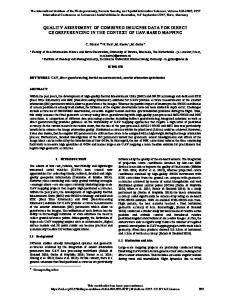
Maximum slewing angle Slewing angle
t1
Field of view
t3 t4
t2
t5
Figure 1. Illustration of satellite observing activity
Point target Observation script
Area target
Figure 2. Illustration of the point target and area target Assume there are a set of area tasks RA ra1 ,, raM to be
observed by satellites S s1 , s 2 ,, s J where J is the number of satellites. For a task rai RA , we define its time windows
2. DYNAMIC SEGMENTING ALGORITHM In the satellite scheduling problem, according to the area of the targets, the imaging tasks can be divided into two types: point target and area target. The point target (e.g. house, bridge) is small so that it can be covered by a single observations trip. As for the area target, which covers a wide geographical area, it cannot be photographed in a scene. The area target may require several contiguous strips to be completely imaged. Usually, the area target can be segmented into several sub-targets to be imaged. As shown in Figure 1, the EOS operates in space in a certain orbit. When the EOS flies over the target area, its sensor is opened to take the image. As the imaging process will last a few seconds, it will produce a strip that covers the target. Since the point task such as t1 is small so it can be covered by a single strip. While the area task like t5 need several contiguous strips to be completely imaged as shown in Figure 2. The process of cutting-up the area target into contiguous strips is controlled by the direction and width of a single strip which depends on the field of view and the height of the satellite. In the paper, we focus on the dynamic areal target triggered by emergent disasters. Due to the wide coverage of the disaster area, we describe it as an area target in our scheduling problem. For area target, segmenting is the first step before modelling. Therefore, we firstly design a dynamic segmenting algorithm to
on satellite j as a set TWi j twi1j , twij2 ,, twiKj ij
where
K ij is
the number of time windows for task rai on satellite s j .For each time window twikj , twikj wsikj , weikj .The dynamic segmenting method that we design is as follows: Step1: For each task rai RA , select the available satellites s j S according to the requirements of users for resolution and so on.
Step2: For each satellite s j S , compute the time windows
TWi j twi1j , twij2 ,, twiKj ij
between ra
i
and s j .
Step3: For each time window twikj TWi j , decompose the area task rai . Step3.1: Within twikj , obtain the minimum and maximum observation angle min i, j , max i, j . Step3.2: Compute the effective observation angle taking the slewing ability of satellite into account:
This contribution has been peer-reviewed. doi:10.5194/isprsarchives-XLI-B1-475-2016
476
The International Archives of the Photogrammetry, Remote Sensing and Spatial Information Sciences, Volume XLI-B1, 2016 XXIII ISPRS Congress, 12–19 July 2016, Prague, Czech Republic
1 j j min max( min (i, j ) 2 , msg ) min( (i, j ) 1 j , msg j ) max max 2
(1)
The uncertainty of the arrival time of emergent tasks will trigger multiple dynamic scheduling during a scheduling period. In other words, the algorithm should be timely adjusted the current schedules of planed tasks for performing new arriving tasks. Let TS {tS1 ,…, tSe , tSf } be the scheduling time set where
tSi ( i 1 ) is the ith dynamic scheduling time, e is the total batch
where = the field of view msg j = the maximum swing angle of satellite s j . j
of emergency tasks and is tSf the end time of scheduling. 3.2 Satellite Resources
Step3.3: Use different observation angle to partition the area target. After setting the excursion angle parameter , obtain
a set of observation angles i, j , ,, j ik 1
j ik 2
j ikVij
where
j ikj 1 min , ikvj ikj ( v 1) , ikm max .
Step3.4: With regard to each observation angle, compute the bounds of strip that satellite can observe which we denote as a meta-task roikvj . As a result, create a set of meta-tasks j roikj {roikj 1 , roikj 2 , , roikV }. ij
Step3.5: For each meta-task roikvj , compute the time window twikvj wsikvj , weikvj with the observation angle ikvj in the scope of twikj . Step4: The meta-tasks decomposed by rai within TWi j is Kij
roi ro j
j ik
With regard to the satellites to perform the imaging tasks, we use S {s1 , s J } to denote them. We assume that the sensors of the satellites considered in our study are able to slew laterally. Each satellite s j S can be denoted by s j ( j , d j , sl j , st j , msg j , orb j , su j , sd j , duty j ) j
j
duty j are the field of view, the longest duration allowed for a continuous observation, slewing rate, attitude stability time, the maximum swing angle, the flight time in each orbit, the start-up time of sensor, the retention time of shutdown and the longest imaging time in each orbit, respectively.
3.3 Time Windows
A task must be performed by the satellites within the available time windows. For a meta-task roikvj , its corresponding the time window is twikvj wsikvj , weikvj with the observation angle
ikvj .We define the time windows of rai as a set
k 1
J
Step5: Let the meta-tasks decomposed by rai on all satellites
Kij Vijk
AOi aoikvj ,where aoikvj {twikvj ,ikvj } , Vijk
is the
j 1 k 1 v 1
number of time windows between satellite sj and meta-tasks set roikj , Kij is the number of meta-tasks of rai on satellite sj, J is the number of satellites.
J
roi roij . j 1
Step6: If all tasks rai RA are partitioned into meta-tasks, then output the results roi, for all i {1, 2,, M } .
3.
3.4 Objective
We assume that tsk is the current scheduling time. The primary objective is to maximize the reward of all observed target area. We think that the actual profit of a task rai is linear with its
MODEL
The satellite scheduling problem usually consists of five parts: tasks, satellite resources, opportunities, objectives and constraints.
observed area ( rai ) : M
max : covi wi
(2)
i 1
3.1 Tasks
In the paper, we focus on the area tasks. Let RA ra1 , , raM be the set of tasks to be observed where M is the number of total area tasks. Each emergency task rai RA has a weight wi, an arrival time ati and a deadline dti. Because the task must be segmented into strips that can be imaged once, we call these strips meta-tasks. In the scheduling model, the meta-task set are J
regarded as input. Let roi roij be the meta-task set of rai j 1
decomposed by segmenting method presented as above. Each meta-task roikvj roij has an indispensable duration of task execution d ikvj .
to describe its observation
capability where , d , sl , st j , msg j , orb j , su j , sd j , j
J
where covi
K ij Vijk
( xikvj (roikvj )) (rai ) j 1 k 1 v 1
(rai )
is the proportion
of acquired area of rai xikvj is the decision variable that can be either 1 if the meta-task roikvj is executed or 0 otherwise. 3.5 Constraints
In our model, regardless of the satellite measurement and control requirements and the data transmission with ground station requirements, there are four constraints that must be satisfied in the model.
This contribution has been peer-reviewed. doi:10.5194/isprsarchives-XLI-B1-475-2016
477
The International Archives of the Photogrammetry, Remote Sensing and Spatial Information Sciences, Volume XLI-B1, 2016 XXIII ISPRS Congress, 12–19 July 2016, Prague, Czech Republic
4. ALGORITHM 3.5.1 Time window constraint: If any meta-task is performed, then the imaging time must be within its time windows. Therefore, we have time window constraint
xikvj tsikvj weikvj 0 j j j j xikv tsikv d ikv weikv 0 k j ati tS tsikv dti
(3)
where tsikvj is the decision variable that denote the start time of the task roikvj . Switch time constraint: In the scheduling scheme
3.5.2 J
SS SS j , where
SS j is composed of a sequence of the
When the current schedule is executing, the users put forward new imaging requests. As a result, the new imaging tasks have to be scheduled. In this case, the current executing schedule must be modified to accommodate these new tasks. So it will result in disturbance to the schedule inevitably. Based on the current scheduling time, tasks may have different states: finished task, running task and waiting task. Only the sequence of waiting tasks can be inserted into new tasks. To arrange new coming tasks as more as possible in smaller disturbances and meet the timeliness requirement of the emergency tasks as well, we design a dynamic rule-based heuristic algorithm in which greedy criterion is embedded(GC-DAHA). The heuristic algorithm can produce satisfactory and feasible plans in a notably short time, which is suitable for large size problems. The greedy criterion acts as a role of heuristic rule, which is the basis and standard of decision-making.
j 1
scheduled tasks ordered in time on satellite sj. There should be an adequate transition time between any two adjacent tasks tm , tn SS j , for sensor to perform the actions including shutting down, swing the observation angle, stabilizing gesture and startup. Hence, we have the switch time constraint:
temj sd j trmj, n su j tsnj where
(4)
temj = the end time of task tm trmj, n sl j mj nj st j denotes the transition time between task tm and tn.
3.5.3 Task merging constraint: The tasks in the same swath of a sensor may be merged into one composite task. Given two j , they can be combined when the following tasks roikvj and roiku conditions hold: j j j j j max weikv , weiku min wsikv , wsiku d ikvj ikuj
(5)
Then the time window and the associated observation angle of the composite task crolj are j Wl j min wsikvj , wsiku , max weikvj , weikvj l j ikvj
(6)
3.5.4 Imaging time constraint: The total imaging time of any satellite sj should be less than the allowable longest imaging time during any orbit period time. Hereby, we have the imaging time constraint
d
i
duty j
(7)
iSSt j b
where SStbj SS j denotes a sequence of scheduled tasks on satellite j which flies during the time span tb [tb , tb +orb j ] ,
tb [tsk , tsf orb j ] .
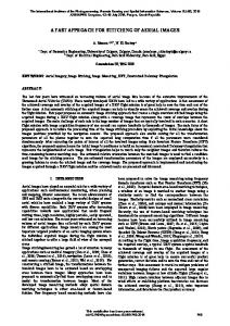
Figure 3. Spatial relationships between scheduled task and emergent task Before the GC-DAHA algorithm, we pretreat each emergent area task firstly. By analyzing the spatial relationship between the task to schedule and the scheduled task in the waiting queue, we conclude that there exist three spatial relationships: disjoint, intersected, containing and contained. In Figure 3(a), we depict the current schedule for area task A. Suppose there comes an emergency task that we must insert to the waiting queue. If the emergent task B and scheduled task A are disjoint, as shown in Figure 3(b), we employ the GC-DAHA algorithm to insert the new emergent task. When the emergent task C intersects with the scheduled task, as shown in Figure 3(c), in the precondition that the two tasks have the same imaging requirement, we remove the intersection area from C and then schedule the remaining region of the task using the GC-DAHA algorithm. In Figure 3 (d), the emergent target is included in the scheduled task. If the former has higher weight, we must schedule the emergent task in priority. Then we schedule the remaining part of the scheduled task A. When the new target includes the scheduled task as shown in Figure 3 (e), we cancel the scheduled meta-tasks of target A and then schedule the new task using the GC-DAHA algorithm.
This contribution has been peer-reviewed. doi:10.5194/isprsarchives-XLI-B1-475-2016
478
The International Archives of the Photogrammetry, Remote Sensing and Spatial Information Sciences, Volume XLI-B1, 2016 XXIII ISPRS Congress, 12–19 July 2016, Prague, Czech Republic
The design of the GC-DAHA algorithm is described as Figure 4. In the GC-DAHA algorithm, each meta-task has three ways to be assigned into a scheduling sequence: insertion by task merging, direct insertion and insertion by deleting. Suppose there come M dynamic area tasks to schedule. Decomposing them into meta-tasks by dynamic segmenting method, we add M
all meta-tasks
ro
i
into a queue Q. Then for all tasks in Q, we
Earth approximately 100 min each time. We set the scheduling period as three days. Task ra1
i 1
calculate the priority p of a task according to the area coverage ( roikvj ) ( rai ) wi . Set p as the greedy and weight: pikvj ( rai )
ra2 ra3
criterion and select the task which has the maximum pikvj to be scheduled by three ways as mentioned above. For the task, we firstly judge whether it can merge with any other existing task in the current schedule. If the task fails to be merged, we attempt to insert the task directly if it does not conflict with any other task. If direct insertion fails, the conflict tasks will be deleted for inserting a new emergency task. The algorithm will terminate if the difference between the objectives which two times calculates is less than the threshold.
Arrival time
Deadline
Weight
Location
9 degree seismic 10 intensity region 2008/05/13 2008/05/14 Wenchuan 12 00:00:00 00:00:00 County 2008/05/14 2008/05/15 Beichuan 14 00:00:00 00:00:00 County Table 1. The information about emergent tasks 2008/05/12 15:00:00
2008/05/15 15:00:00
M
Set
Q roi i 1
Initialize the schedule
S*
Figure 5. The simulated result
calculate the priority p of each task in Q
Meta task
select the task which has the maximum p
1 2
Is task merging successful ? Y N
3
Is direct insertion successful ? N
4
N Y
insert the task by deleting
Meta task
Remove the task from Q
Remove the intersection area between task and rai
( rai ) ( ro ) ( rai ) j ikv
2
Terminate?
5
Y Output the schedule
1
6
S*
Figure 4. The algorithm of GC-DAHA Meta task
5. EXPERIMENT
We take Wenchuan Earthquake as the emergent event. After the earthquake occur, users will summit the imaging requirements. Based on the situation of disaster relief at that time, we simulate three batches of emergent tasks, which are located on 9 degree seismic intensity region, Wenchuan County, Beichuan County, respectively. As shown in Table 1, we present the information of tasks in detail. To complete the imaging tasks, we choose three satellites: GF-1, ZY1-02C, ZY-3. Each satellite circles the
7
Assigned satellite
Start time
Duration/s
05/13 10:12:09 05/13 ZY3 15:31:04 ZY105/14 02C 12:43:34 ZY105/15 02C 12:11:12 Table 2. The schedule GF-1
Assigned satellite
Start time
Slewing angle/°
12
2.5
16
25
25
-22.5
29
25
* 1
S
Duration/s
05/13 22 10:12:03 05/13 ZY3 16 15:31:04 ZY105/14 15 02C 12:43:45 ZY105/15 29 02C 12:11:12 Table 3. The schedule S2* GF-1
Assigned Start time Duration/s satellite ZY105/14 31 02C 12:43:22 Table 4. The schedule S3*
Slewing angle/° 0 25 -20 25
Slewing angle/° -25
When the earthquake breaks out, there is an urgent need to acquire the information about stricken area as soon as possible. The first imaging requirement is to acquire the information of 9 degree seismic intensity region. We use the GC-DAHA
This contribution has been peer-reviewed. doi:10.5194/isprsarchives-XLI-B1-475-2016
479
The International Archives of the Photogrammetry, Remote Sensing and Spatial Information Sciences, Volume XLI-B1, 2016 XXIII ISPRS Congress, 12–19 July 2016, Prague, Czech Republic
algorithm to obtain the first schedule S1* , as shown in Table 2. From Figure 5(a) and Table 2, we can observe that the area task ra1 is decomposed into four meta-tasks which are assigned to satellites and execution periods. The region of task ra1 is entirely covered by observation strips. After collecting a portion of disaster information, the user puts forward new imaging requirement to observe Wenchuan County, namely ra2 . Hence, this triggers the second dynamic scheduling. We insert new emergent task to S1* and the second schedule S2* is produced, as depicted in Figure 5(b) and Table 3. The result indicates that two meta-tasks are adjusted to satisfy new emergent requirement. As more disaster information has been obtained, the user submits a new imaging requirement to observe ra3 , which is the worst-hit region. Then dynamic scheduling is triggered again. The new schedule S3* is shown in Figure 5(c) and Table 4. From the result, it is found that two meta-tasks have been performed observation until the third scheduling time. So there remain two meta-tasks in the waiting queue. The new task ra3 are arranged in the third schedule S3* by cancelling the two conflict tasks. Besides, the expected reward of each schedule and the disturbance to the previous schedule are shown in Table 5. The disturbance is defined as total adjusted meta-tasks in each schedule. The results prove that the GC-DAHA algorithm can produce a schedule with high reward and small disturbances as far as possible. Schedule
Accumulated reward
Disturbance
* 1
10
0
* 2
22
2
S S
* 3
REFERENCES
Bai, B., Chen, Y., He, R., and Ruan, Q., 2009. Multi-satellite scheduling Toward Spot and Polygon observing Request. Journal of Astronautics, 30(2), pp. 755-759. Bensana, E., Verfaillie, G., Agnese, J. C., Bataille, N., and Blumstein, D., 1996. Exact &inexact methods for daily management of earth observation satellite. Space Mission Operations and Ground Data Systems (SpaceOps’ 96), pp. 507515. Bianchessi, N., Cordeau, J. F., Desrosiers, J., Laporte, G., and Raymond, V., 2007. A heuristic for the multi-satellite, multiorbit and multi-user management of Earth observation satellites. European Journal of Operational Research, 177(2), pp. 750762. Gabrel V. and Vanderpooten D., 2002. Enumeration and interactive selection of efficient paths in a multiple criteria graph for scheduling an earth observing satellite. European Journal of Operational Research, 139(3), pp. 533–542. Hall, N. G., and Magazine, M. J., 1994. Maximizing the value of a space mission. European Journal of Operational Research, 78, pp. 224-241. Lemaitre, M. and Verfaillie, G., 1997. Daily management of an earth observation satellite: comparison of ILOG Solver with dedicated algorithms for Valued Constraint Satisfaction Problems. Lemaı̂ tre, M., Verfaillie, G., Jouhaud, F., Lachiver, J. M., and Bataille, N., 2002. Selecting and scheduling observations of agile satellites. Aerospace Science and Technology, 6(5), pp. 367-381.
35.09 1 Table 5. The reward and disturbance of schedules
Li, J., Yao, F., Bai, B., and Ruan, Q., 2008. Cooperative mission planing problem for area targets observation by multi satellites. Science of surveying and mapping, 33(S1), pp. 54-56.
6. CONCLOSION
Li, J., Yao, F., Bai, B., and He, R., 2009. A decompositionbased algorithm for imaging satellite scheduling problem. In Information Engineering and Computer Science, 2009. ICIECS 2009. International Conference on, pp. 1-6.
S
To address the scheduling problem oriented to the dynamic areal tasks triggered by emergent disasters, we build a mathematical model in which the reward of the schedule is maximized. The dynamic segmenting algorithm is designed to partition area targets. Then we employ the GC-DAHA algorithm to obtain the optimal solution. To evaluate our model, we conduct experimental simulations in the scene of Wenchuan Earthquake. The simulated imaging plan can schedule satellites to observe a wide scope of target area. We conclude that our satellite scheduling model can optimize the usage of satellite resources so as to obtain images in disaster response in a more timely and efficient manner.
ACKNOWLEDGEMENTS
This work is partly supported by the National Basic Research Program of China (No. 2011CB707102), the National Natural Science Foundation of China (No. 41571334) and the Fundamental Research Funds for the Central Universities.
Lin, W. C., Liao, D. Y., Liu, C. Y., and Lee, Y. Y., 2005. Daily imaging scheduling of an earth observation. Systems, Man and Cybernetics, Part A: Systems and Humans, IEEE Transactions on, 35(2), pp. 213-223. Mancel, C. and Lopez, P., 2003. Complex optimization problems in space systems. In 13th International Conference on Automated Planning & Scheduling (ICAPS’03). Mansour, M. A. and Dessouky, M. M., 2010. A genetic algorithm approach for solving the daily photograph selection problem of the SPOT5 satellite. Computers & Industrial Engineering, 58(3), pp. 509-520. Niu, X., Tang, H., Wu, L., Deng, R., and Zhai, X., 2015. Imaging-duration embedded dynamic scheduling of Earth observation satellites for emergent events. Mathematical Problems in Engineering, 2015. Pemberton, J. C., 2000. Towards scheduling over-constrained remote sensing satellite. Proceedings of the 2d International Workshop on Planning and Scheduling for Space.
This contribution has been peer-reviewed. doi:10.5194/isprsarchives-XLI-B1-475-2016
480
The International Archives of the Photogrammetry, Remote Sensing and Spatial Information Sciences, Volume XLI-B1, 2016 XXIII ISPRS Congress, 12–19 July 2016, Prague, Czech Republic
Ruan, Q., Tan, Y., Li, J., and Chen, Y., 2006. Research on segmenting and Selecting for area targets. Science of surveying and mapping, 31(1), pp. 98-100. Walton, J. T., 1993. Models for the management of Satellitebased sensors (Doctoral dissertation, Massachusetts Institute of Technology). Wang, J., Jing, N., Li, J., and Chen, Z. H., 2008. A multi objective imaging scheduling approach for earth observing satellites. Proceedings of the 9th Annual Conference on Genetic and Evolutionary Computation, 36(9), pp. 1715-1722. Wang, P., Reinelt, G., Gao, P., and Tan, Y., 2011. A model, a heuristic and a decision support system to solve the scheduling problem of an earth observing satellite constellation. Computers & Industrial Engineering, 61(2), pp. 322-335. Wu, G., Liu, J., Ma, M., and Qiu, D., 2013. A two-phase scheduling method with the consideration of task clustering for earth observing satellites. Computers & Operations Research, 40(7), pp. 1884-1894. Zhai, X., Niu, X., Tang, H., Wu, L., and Shen, Y., 2015. Robust Satellite Scheduling Approach for Dynamic Emergency Tasks. Mathematical Problems in Engineering, 2015. Zhang, Z., Zhang, N., and Feng, Z., 2014. Multi-satellite control resource scheduling based on ant colony optimization. Expert Systems with Applications, 41(6), pp. 2816-2823.
This contribution has been peer-reviewed. doi:10.5194/isprsarchives-XLI-B1-475-2016
481