only when a resident is homeward bound [13,25], 2) intelligent context-aware meeting/schedule organizers [6], 3) intelligent automotive navigation systems.
n-gram Geo-Trace Modeling Senaka Buthpitiya, Ying Zhang, Anind K. Dey, and Martin Griss Carnegie Mellon University, 5000 Forbes Avenue, Pittsburgh, PA 15213, USA {senaka.buthpitiya, martin.griss}@sv.cmu.edu {joy, anind}@cs.cmu.edu
Abstract. As location-sensing smart phones and location-based services gain mainstream popularity, there is increased interest in developing techniques that can detect anomalous activities. Anomaly detection capabilities can be used in theft detection, remote elder-care monitoring systems, and many other applications. In this paper we present an ngram based model for modeling a user’s mobility patterns. Under the Markovian assumption that a user’s location at time t depends only on the last n − 1 locations until t − 1, we can model a user’s idiosyncratic location patterns through a collection of n-gram geo-labels, each with estimated probabilities. We present extensive evaluations of the n-gram model conducted on real-world data, compare it with the previous approaches of using T-Patterns and Markovian models, and show that for anomaly detection the n-gram model outperforms existing work by approximately 10%. We also show that the model can use a hierarchical location partitioning system that is able to obscure a user’s exact location, to protect privacy, while still allowing applications to utilize the obscured location data for modeling anomalies effectively.
1
Introduction
Over the last decade, with smart-phone and ubiquitous computing technologies maturing, the ability to locate a user accurately has become a reality especially in outdoor environments using the Global Positioning System (GPS). With the ability to accurately track a user’s location, it is theoretically possible to create a model for that user’s movement pattern [11]. Such a model, combined with location-based services (and context-aware services in general), enables opportunities to provide a wide array of services using the model’s ability to detect variations from a regular routine, and its ability to predict location and variations. A comprehensive model of a user’s movement patterns would be able to detect if a user is doing something out of the ordinary. This anomaly detection capability of the model can support context-aware applications for 1) caregivers to monitor elderly people unobtrusively (especially those suffering from memory ailments such as Alzheimer’s Disease who are likely to wander), 2) monitoring of young children, and 3) theft detection systems for mobile phones and cars. In this paper we present an n-gram based model for learning a user’s movement pattern using historical geo-traces (GPS tracks). Each person has a set
of unique geo-locations and transitions (i.e., movements between those geolocations) which act as triggers or qualifiers for the person’s future locations. n-gram models are very robust at modeling relationships between a sequence of observations and outcomes dependent on the sequences. Therefore we use an n-gram model to learn a person’s geo-patterns. For example, if a person visits a cafe everyday on the way to work and the person is seen at the cafe on a workday, it can be reasonably assumed that the person is on his way to work. We cluster raw GPS coordinates into geo-labels, and use sequences of geo-labels to train standard n-gram models for anomalous activity detection. Using probabilistic methods for modeling the movement patterns of users has been attempted in previous work. These approaches have focused predominantly on using probabilistic approaches such as Markov models [30, 19, 1, 16] and TPattern based models [22, 10]. Yet anomaly detection using GPS traces is a novel area of research with sparse previous work. In [21], Ma proposes using generating bounding regions (with borders parallel to the longitudinal and latitudinal lines) for anomaly detection, while Binbin proposes Markov Random Fields for learning geo-tracks of people and for anomaly detection [18]. Yet, neither have as yet produced definitive results. The work presented in this paper approaches the problem of grouping individual entries in geo-traces with a method that is distinct from previous attempts. Our method utilizes previous states (or locations) to detect anomalies in daily routines similar to using a T-Pattern or Markovian model. However, unlike those models, the n-gram based model presented here is able to skip over previous locations which are detractors (or non-contributors) to the current prediction. By skipping over location entries which are deemed to be detractors or non-contributors, the n-gram model is made more robust to noise in data caused by either GPS resolution or minor variations in a user’s movements. Furthermore skipping detracting n-grams reduces the size of the model in terms of computational time and storage size (as the model has comparable performance for a lower value of n than when the model takes detracting grams into account). Therefore the work presented here is able to outperform models presented in previous work at detecting anomalies. In this work, we make the following contributions toward the problems of mobility pattern modeling and anomaly detection in mobility patterns: – We present an n-gram based model for modeling human mobility, which employs unsupervised learning. – We show how this model is used for detecting anomalous behavior of a user given that user’s current context. – We present a geo-partitioning method, used by our model, that preserves a user’s privacy when exposing location information to external applications by blurring GPS coordinates and, at the same time, retains enough information for mobility modeling with sufficient accuracy. – We evaluate the model’s anomaly detection capabilities with extensive realworld data, and show that it outperforms other behavior modeling approaches to anomaly detection.
This paper is organized as follows. In Section 2, we describe the properties of geo-trace data and show how our method utilizes these properties. In Section 3, we describe our approaches to quantizing geo-tags and training the n-gram model. In Section 4, we evaluate our approach with experimental results. Then, in Section 5, we discuss the experimental results and describe the class of applications enabled by anomaly detection using the n-gram model. We conclude after reviewing related work in the area of geo-trace modeling in Section 6.
2
Quantizing Geo-trace Data
Raw geo-trace information can be recorded from either a user’s mobile phone (using GPS) or specialized GPS hardware. While some specialized geo-tracking devices are capable of providing a greater amount of information about the user’s movements (such as velocity), we assume that the only information available to our model is raw, timestamped GPS coordinates (longitude and latitude) along with the number of visible GPS satellites. We use the satellite count to clean the data, rather than as a feature for the model [1]. In this paper, we use the term “geo-tag” to describe a tuple of raw readings consisting of a longitude-latitude pair, timestamp, and visible satellite count, and use the term “geo-label” to describe a tuple of quantized geo features derived from the raw data. The geo-trace models are built upon these geo-labels. 2.1
Location Quantization through Partition
We do not use raw GPS readings as a part of geo-labels, since the precision of the raw GPS readings is too high to generalize to a meaningful geo-trace model (i.e., the geo-trace models will attempt to learn with an unrealistic degree of granularity, resulting in many false positives/false anomaly detections). For example, knowing that the user is driving on highway I-75 close to exit 187 heading north is enough to detect his/her future location and we do not really need to know which lane he/she is at to achieve such a prediction. Essentially, in this example, we treat the left and right lanes as one location rather than two. Additionally, users may have privacy concerns over sharing precise location information with an external application (such as a server/cloud-based application utilizing geo-trace models) [15, 3, 16]. Therefore we abstract the raw GPS readings to reduce their precision and to generalize them to a useful geo-trace model. We now discuss two methods to perform this conversion. Equal-sized Partition The first method is to partition the entire surface of the earth into equal sized rectangular segments, each with a unique label. Then, all points from a geo-trace falling within a certain segment are replaced by the label of that segment. This method of partitioning is very straightforward to implement and makes comparisons between multiple users’ geo-traces extremely simple. But the method also has the drawback of over- and undergranularization. In the case of over-granularization, in areas where a user rarely travels, the few geo-tags that exist (over a relatively large geographic area) are
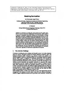
split into a large number of partitions. In the case of under-granularization, areas regularly frequented by the user will have a large number of places of interest (e.g., campus premises with different buildings of interest) and a low granularity of partitioning could lose important information regarding visits to each individual place of interest within the partition. Density-driven Hierarchical Partition To counter the deficiencies of the first partitioning approach, we propose a density-driven partitioning method where the granularity of partitioning varies from area to area. The granularity of partitioning for an area is determined by the frequency of visits to that area, based on observed geo-traces of a user or a group of users. The process begins by treating the entire world surface as a single partition and recursively dividing it up into child partitions by splitting it into four quadrants with a north-south line and an east-west line. Further division of a partition is halted when the number of geo-tags recorded within that partition falls below a density threshold. The resulting partition is a quad-tree. We assign a label to each leaf partition which denotes the path to the leaf node from the root node in the partitioning quadtree. Each child partition’s label is comprised of the parent partition’s label as a prefix appended with a designator as to which quadrant of the parent it belongs. See Figure 1 for an example of a partitioned area on a user’s route. The pseudocode for the partitioning algorithm is: Create root Partition with root->region = entire world; Assign all geo-tags to root; PartitionSimple( root ); PartitionSimple( Partition cp ) { IF( cp->geo-tags region = quadrant i of cp->region; Set p->label = Concatenate( cp->label, i ); FOR EACH geo-tag gt IN cp IF (gt lies within p) THEN Assign gt to p; END PartitionSimple( p ); i = i + 1; END } While there are partitioning schemes such as Hierarchical Triangular Maps which would result in a more even spacial partitioning, these scheme require greater computational cost at run-time. Furthermore such partitioning schemes do not provide significant performance improvements.
A
AA
AB A
AC
AAA
AD
AAB
AA AB AAC AAD AADA ADB AC ADCADADD Fig. 1. The map on the left displays a partition based on the frequency of visits by the user. The image on the right shows an example of how labels are assigned to partitions in a density based partitioning scheme.
2.2
Time and Direction Features
We also extract features other than location information for geo-trace modeling. – direction of displacement. The direction of displacement of a geo-tag gi is the angle of the directional vector gi − gi−1 , i.e., the direction the user moves from his previous location to the current location. The direction is 0 if gi − gi−1 points to North and 90 if East. Similar to quantizing locations, we also quantized direction of displacement into B sectors where B