1569937613
Navigating Through Dynamic Indoor Environments Using WIFI for Smartphones
Vinjohn V Chirakkal
Myungchul Park
Dong Seog Han
School of Electronics Engineering Kyungpook National Univeristy Daegu, Korea
[email protected]
School of Electronics Engineering Kyungpook National Univeristy Daegu, Korea
[email protected]
School of Electronics Engineering Kyungpook National Univeristy Daegu, Korea
[email protected]
Ahstract- In recent days with a huge mass deployment of
implements fingerprinting technique using a deterministic approach making it feasible to be implemented on a smartphone as the complexity of the probabilistic method is too high to be performed on a mobile device. The technique of fingerprinting localization [6] consists of two phases, the offline phase and the online phase. During the offline phase a set of RSS values is collected from various access points at different reference points (RPs) to form a database or radio map. And during the online phase the mobile terminal (MT) location would be obtained by using pattern matching algorithms to compare the real time fingerprint collected with those of the database. This paper emphasizes on an adaptive algorithm (proposed algorithm) for a dynamic indoor environment. A dynamically changing environment is characterized by the changing sets of receiving access points during online and offline phases. That
wireless networks, smartphones and various related services, different navigation techniques have been developed for indoor environments. Leveraging on these wireless networks, this paper proposes an indoor navigation model for a smartphone using WIFI. While a number of methods have been developed using received signal strength (RSS) based fingerprinting; only seldom approaches consider the dynamicity of the indoor environments. To tackle this limitation, we propose a positioning algorithm based on RSSI - fingerprinting and Manhattan distance which addresses navigation in a rapidly changing indoor environment. The model described is one of the efficient methods in terms of memory and battery consumption.
Index
Terms
WIFI,
Indoor
localization,
RSSI,
Fingerprinting, Manhattan distance.
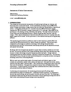
I. INTRODUCTION With the extensive deployment of the wireless networks, the location based services (LBSs) are made possible on mobile devices like smartphones, laptop and personal digital assistants (PDAs). There exists a range of applications that rely on the location information of these mobile devices which includes indoor navigation. Due to the failure of GPS to deliver reliable services in indoor environments, other techniques like ultra wideband (UWB) [I] , FM [2] , RFID [3] , etc. are being considered. But these techniques would require additional infrastructure and sensors to be installed in order to get good and consistent LBSs thereby, increasing the cost of implementation. Therefore, apart from the above mentioned techniques, we opt the WIFI [4] based system as it is extensively used for the positioning purposes due its widespread deployment.
Collection of RSSI t---�� Making of database values at various RP
Map downloaded to MT
RSSI measurement using MT at current location
II. WTF T BASED POSITIONING The consistent advancement and increasing popularity of WIFI lead to the development of many positioning systems that exploit these infrastructures. Features like larger coverage area with a high speed transmission rate make WIFI viable to aid positioning systems in indoor environments. The fingerprinting approach can be bifurcated [5] into deterministic and probabilistic methods. This paper
978-1-4799-6165-8/14/$31.00©2014 IEEE
376
Fig. I. Block diagram for proposed model.
Discerning selection of APs using
1569937613
is, during the offline phase and online phase, there are chances of receiving different sets of access points for the same reference points. This phenomenon is attributed to fading of signals due to continuous change in indoor environments. This problem is addressed by considering the matched access points from access points collected during offline phase and the access points from the online phase. Therefore, we calculate the distance between the database sets and the online data set using only those access points that are visible in both database and online phase. If an access point (AP) in the database does not appear during the online phase or vice versa that particular AP is dropped from consideration while calculating the distance measurement. The conventional algorithm does not take into account the dynamic changes in the indoor environment and considers all the APs irrespective of the appearance of APs in a database or online phase. The distance calculation between database sets and online set can be done using Euclidean distance or Manhattan distance. The comparison can be seen in Fig. 2. This paper compares Euclidean and Manhattan distance metrics so as to select the one with less error. The simulations shown in Fig. 2 reveal that the Manhattan distance with the proposed algorithm shows a better result than the rest.
distance between the data sets collected during offline phase and the data set collected during online phase, (ii) K- nearest neighbor (KNN) determines the location of the user based on k nearest locations which are obtained by the Manhattan distance. The location of the test vector PKNN received during online phase using K- nearest neighbor can be formulated as
PKNN =
k
�
I
k
(2)
Pi
where k is no. of nearest neighbor considered which are obtained by the Manhattan distance. In this paper the value of k is taken as 3. Pi are the k nearest locations and (iii) weighted K-nearest neighbor (WKNN) determines the location of the user based on k nearest locations which are obtained by the Manhattan distance and on weights which are the Manhattan distance between each of the nearest location from the test vector. The location of the test vector PWKNN received during the online phase using weighted K-nearest neighbor can be formulated as k
�)p; Jd) 2
-
2(
conv. conv. prop. prop.
-
--_0_ .
.
---
Euclidean Manhattan Euclidean Manhattan
(
.t::: ( 8
/
/
/
/
/
/
'" '" '"
/ '" '" '" / '" '" 4 '" / ", - - - 2 '" ' �L- .6
/
'"
-
PWKNN =
-
-
-
i=l
I(lJd)
where no. of nearest neighbor
'"
(3)
...:.k---.::.;
i=l
/
'" '" '"
- -
-
-.,...
-'
-
--
--
. -.- . -
'
-
'
is taken as 3,
nearest locations and the weights denoted as
-
-
k
d;
Pi
are the
which is the
Manhattan distance. When the positioning algorithms mentioned above are compared, WKNN shows better performance than other algorithms in terms of accuracy as shown in Table I. These positioning algorithms depend on the distance metric that gives the distance between the test vector and the database vectors.
'
.
2
4
12 10 6 8 distance in meters Fig. 2. Plot between conventional and proposed with the distance metric.
TABLE I. COMPARISON OF MATCHING ALGORITHMS
14
Therefore the posItIOning model that incorporates Manhattan distance for dynamic indoor environments can be expressed as
(1)
where
d
m
,m, RSS
Di'
and
RSS Ci'
are the Manhattan distance,
number of matched access points, RSS values of the database and RSS values of the current location respectively. Based on Manhattan distance, the positioning algorithms [7] considered in this paper include (i) nearest neighbor (NN) where the location is classified based on the least Manhattan
377
Matching Algorithm Nearest neighbor (NN) K Nearest neighbor (KNN) Weighted K Nearest neighbor (KNN)
Avg. Error 4.3m 3.9m 3.6m
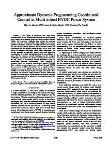
Therefore, based on the above results, this paper considers WKNN to determine the location of the user in indoor environments. The algorithm combining the proposed algorithm with WKNN is implemented on a blueprint of Kyungpook National University as shown in Fig. 3. Each grid on the blueprint seen is one square foot. The accuracy is determined to be 3.6m as shown in Table I. To eliminate the outlier data and for a smooth traced path we apply certain filters. The filters used in this paper to improve the accuracy are a median and an average filter. The final path traced on the given blueprint would be as shown in
1569937613
Fig. 4. The accuracy of the proposed algorithm with filtering technique is determined to be 2.5m. In the normal approach [8] followed, during the offline stage the readings from all the four directions are taken into consideration for location determination which is time consuming and a tedious task. Also in some cases [4] the variances of the RSS reading from different APs at different orientations are stored in the database. This lays a heavy burden on the memory and the battery consumption of the smartphone which leads to additional establishment of server for the storage of database thereby increasing the infrastructure cost. In this proposed algorithm the location determination is carried out taking the RSS values in one single orientation. Therefore the proposed algorithm has a lesser impact on the memory of the smartphone. Taking the tradeoff between the infrastructural cost and accuracy the proposed algorithm shows a better performance. Hence the proposed model takes care of the practicality in implementing the model on a smartphone in terms of memory and battery consumption.
III. CONCLUSION This paper proposes a model for navigating in indoor dynamic environments also making an efficient use of memory and battery. This model stands apart from others in terms of less complexity and ease of implementing it on a smartphone with a good average accuracy of 2.5 m. ACKNOWLEDGMENT
This work was supported by the Ministry of Science, ICT & Future Planning (MSIP), Korea, under the IT R&D program coordinated by Electronics and Telecommunications Research Institute (ETRI) and also supported by MSIP under the Convergence Information Technology Research Center (C ITRC) support program (NIPA-20l4-H040l-14-1004) supervised by the National IT Industry Promotion Agency (NIPA)."
REFERENCES
[I]
X. Li and K. Pahlavan, "Super-Resolution TOA Estimation with
Diversity for Indoor Geolocation," IEEE Trans. Wireless Comm., voI. 3, no.l, pp. 224-234,Jan. 2004
512
�-- .. --.
519
[2]
Y. Chen, D. Lymberopoulos, 1. Liu and B. Priyantha, "Indoor Localization Using FM Signals," IEEE Trans. Mobile Computing, vol. 12, no. 8, Aug. 2013.
[3]
L.M. Ni et al., "LANDMARC: Indoor Location Sensing Using Active RFID," Proc. 1st IEEE Int'[ Con! Pervasive Computing and Communication, IEEE CS Press, 2003.
[4]
Feng, W. Au, S. Valaee, Z. Tan, "Received signal strength based indoor positioning using compressive sensing", IEEE Trans. on mobile computing, vol. 11, no.12, Dec. 2012..
[5]
M. Vuckovic, 1. Petrovic, Deni Vidovic and D. Kukolj, "Space Grid Resolution Impact on Accuracy of the Indoor Localization Fingerprinting", 19'h telecomm. Forum TELFOR, Nov. 2011.
[6]
K. Kaemarungsi and P. Krishnamurthy, "Modelling of Indoor Positioning Systems Based on Location Fingerprinting," Proc. IEEE INFO COM, vol. 2, pp. 1012-1022, Mar. 2004.
[7]
V. Moghtadaiee, A.G. Dempster and S. Lim, "Indoor localization using FM radio signals: a fingerprint approach", Int'l Con! on Indoor Positioning and Indoor Navigation, Sept. 2011.
[8]
O. Gani, C. O'Brien, S.Ahamed and R.Smith, " RSSI based indoor localization for smartphone using fixed and mobile wireless node", Int'l Con! on Cmputer Software and application, 2013.
520
••
-"":!,
?-
__
rllow�tJ IIf«'C1 '11)1119
•..,1>
_
W�HN
S11
Fig. 3. Path traced using WKNN algorithm without using any filters.
r
-
Ilf
\.
True path Path traced using proposed method with filtprc;.
I I I
Fig. 4. Plot of path traced using proposed model with filters.
378