New experimentation of a generic framework for architectural heritage data visualisation I.Dudek
J.Y.Blaise
UMR CNRS/MCC MAP 694 GAMSAU EAML 184 av de Luminy 13288 Marseille cedex 09 France
UMR CNRS/MCC MAP 694 GAMSAU EAML 184 av de Luminy 13288 Marseille cedex 09 France
[email protected]
[email protected]
ABSTRACT When studying patrimonial edifices or sites, documentary sources, may they originate from archives or from contemporary survey campaigns, provide partial evidences from which the researcher will infer possible scenarios on how an edifice or site may have evolved throughout the centuries. Documentation analysis and visualisation are therefore vital to the understanding of the architectural heritage. They are the only scientific basis from which virtual renderings can be proposed and justified. Still, the making of 3D scenes in our field of experimentation is most often only in relation with communications goals. Virtual renderings, although presented as visualisations of an edifice, totally mask the semantics behind the scene, meaning the reasons behind the shapes and in definitive any kind of scientific analysis since they provide certainty where only probability should be considered. Such seducing results may be of great use, they may be considered as a visualisation of geometrical shapes, but in no way can they be considered as visualisation of architectural heritage data. We propose an approach of data visualisation in which 3D scenes act as interpretative interfaces to the documentation, and in which the objects represented are given appearances that show what can be stated form the reading of each object’s documentation. We have defined a methodology in which the documentation is analysed and attached to architectural concepts with respect to the notion of scale, and in which the concepts are given representations that are used both as visualisations of the documentation’s analysis and as interfaces in the documentation’s database. Our experimental set is the centre of the city of Kraków (Poland). We introduce in this paper several recent developments of our research : a combination of persistence mechanisms that includes XML parsing and RDBMS, links between objects and documentary sources, symbolical visualisation of undocumented / non-dimensioned objects. We also introduce a recent experimentation of this framework at structural scale on major edifices in Kraków’s city centre.
Keywords Applications, Scientific visualisation, architectural heritage, virtual reality, VRML, interpretative modelling.
1. INTRODUCTION In the field of the architectural heritage, documentation and visualisation play essential roles, as established by [Alk93]. But what solutions can one find when wanting to retrieve information on the Permission to make digital or hard copies of all or part of this work for personal or classroom use is granted without fee provided that copies are not made or distributed for profit or commercial advantage and that copies bear this notice and the full citation on the first page. To copy otherwise, or republish, to post on servers or to redistribute to lists, requires prior specific permission and/or a fee. Journal of WSCG, Vol.11, No.1., ISSN 1213-6972 WSCG’2003, February 3-7, 2003, Plzen, Czech Republic. Copyright UNION Agency – Science Press
former using the graphical signs available in the latter? And how can one mark those graphical signs with indications about the content of the former? These are the two basic questions that our paper addresses. In the field of geography, or let’s say at the scale of territories, GIS platforms have provided formalisms that enable a native connection of the graphical sign to the information it localises and signifies. Such platforms have been used at the scale of architecture notably in archaeological site management or urban planning (see for instance [Bil97] or [Ioa99]). But in the case of patrimonial architecture at its various scales, geometry cannot be considered as a relevant intermediate between the documentation and the edifice, as established by [Bou71]. One of the
difficulties is that dimensional aspects are in most cases hypothetical but in all cases do require the third dimension. In the field of geometry, and particularly in connection with support for surveying, experiments have been carried out in order to attach information to the geometrical results of the survey campaign, typically 3D points as experimented in [Whi97]. But in the case of patrimonial architecture a 3D point or any other geometrical being is a totally irrelevant concept to attach information to. What historical reference mentions “a 3D point” ? What book, illustration, painting, inventory can be attached to a geometrical being? In both the fields of GIS and surveying, there have been efforts in order to find theoretical concepts that can serve as interfaces between information and visualisation platforms. We believe that in our field of experimentation the geometrical concepts will fail coping with the complexity of the architectural documentation because they are just not the concepts people who document buildings deal with. Still, we consider that the edifice’s shape can be used in order to interface documentary sources. But the information that characterises an edifice or a site can be fruitfully put in relation to theoretical concepts, provided that those concepts originate from the world of those who study edifices: architects, archaeologists, conservators, historians, etc.
Preservation of the architectural and urban heritage includes a concern for the edifice itself, but it also includes a concern for the edifice’s documentation for which we lack appropriate visualisation platforms. In our research area, the meaning of the word visualisation is often narrowed to this of virtual reconstruction. But an undocumented virtual reconstruction can hardly be considered as something more than as a dead-end (see [Kan00]). Although realistic 3D models prove relevant with respect to communication goals [Bur97], we favour an approach in which what is “beyond” the image is more important that the image itself, in line with contributions like [Ste91] or [Alk93]. What we try to visualise is a momentary state of knowledge on the edifice’s evolution. In previous contributions, we have introduced our position on interpretative modelling in the field of the architectural heritage with regards to visualisation issues [Dud01] and on the use of 3D models as interfaces with regards to documentation issues [Dud02]. We will in this paper very briefly sum up these aspects, and focus on data visualisation issues, meaning how can we provide support for the visualisation inside 3D scenes of a qualitative analysis of the documentation. We will discuss the main elements and recent developments of our methodological framework and will also detail the following aspects: −
− − −
The combination of persistence mechanisms, including XML parsing and RDBMS, that we have developed in order to handle the persistence of the architectural model’s instances and of the documentation. The links between the architectural model’s instances and the documentary sources The symbolical visualisation of undocumented / non-dimensioned objects. A recent experimentation of this framework at structural scale on major edifices in Kraków’s city centre.
2. VISUALISATION ISSUES
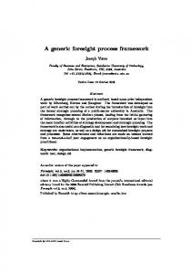
Figure 1 : The city of Kraków, interpretative 3D interface, and situation in the city
We introduce a methodology in which theoretical architectural concepts are identified and structured with regards to the Object Orientation classification paradigm. Each such concept can be documented and represented inside VRML (Virtual Reality Modelling Language) scenes that act as 3D, graphical interfaces to the documentation but also as graphical visualisation of the documentation’s content.
As mentioned above, architectural heritage is an application domain in which both documentation and visualisation play essential roles. Moreover, ensuring their interdependence has clearly been acknowledged by authors as a key issue (see for instance [Ste91] or [Nak99]): -
Visual results such as VR scenes can in no way be considered as elements of information in a research process if they are not put in relation with a documentation that authenticates, validates, explains each particular arrangement of architectural shapes the reconstruction proposes.
Finally, it has to be stressed that in our research area a physical object such as “an opening” can have been re-used several times during history, and often inside different edifices. Both the shapes reconstructed and the documentation relate to a moment in time. This introduces a level of complexity for which we lack adequate formalisms since such issues as dynamic data visualisation [Rus01] or time handling in GIS sytems [Bil97], although already addressed, do not bring operational breakthroughs in our application domain. Where [Tos00] writes “hypertexts are communication”, we would want to write “3D architectural concepts are information”. This author investigates the problems of links’ relevance in a field that is not ours. But there is a clear parallel to draw in our field of experimentation since we want to answer not only to the question -What did John Smith write?but also to the question - What did John Smith write about the gothic phase of the town hall? -and moreover to this question -What information, what documents, can I find on the buttress of the town hall’s gothic phase?- allowing searches on what the document is about (edifices at different periods in time).
3.1.1 Data collection The methodology used by historians of architecture and conservators in order to analyse evolutions of an architectural object is based on the interpretation and comparison of various types of documentation, as stated in the [Cra00] charter. Therefore the idea that different pieces of documentation are in relation to architectural elements (a building, a portal, etc.), is for them a natural (although often unspoken) part of their work methodology. One key goal of our research is to capture, capitalise and visualise the actual basis of this methodology –relations between an architectural artefact and the wide range of documents that refer to it. What is more, the documentation that we describe is stored in various collections, each of them having its own classification and access policies. Having it in mind we consciously avoid giving a direct access to sources. Our proposal introduces a distributed computer architecture in which we only refer to pieces of information that are detained by various institutions. Our goal to localise documents in terms of : − −
In which library(ies) can they be found? To which architectural objects do they refer?