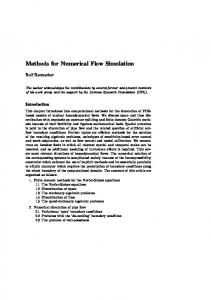
This leads to reduced water exchange between the lagoon and the sea resulting in ... Satellite Image for Bardawil Lagoon, Egypt showing the inlets to the Sea.
NUMERICAL SIMULATION FOR FLUSHING RATE IN BARDAWIL LAGOON, EGYPT
S. ABOHADIMA1, D. EL-BAGOURY2 AND K.A. RAKHA3
ABSTRACT The Bardawil lagoon along the northern coast of Sinai, is one of the largest salt water lagoons in Egypt. It is an important lagoon for fishing. The inlets of the lagoon are subject to changes in the morphology over time, including sediment infilling of the inlet channels. This leads to reduced water exchange between the lagoon and the sea resulting in poor circulation in the lagoon. The hydrodynamics is calculated inside the Bardawil lagoon using the RMA-10 model. The flushing calculations are simulated using the advection dispersion of a conservative material inside the lagoon using the RMA-11 model. Several alternatives are considered to reduce the flushing time of the lagoon and improve water exchange. Adding two inlets at the west and the east provided the best results (flushing time 40% of existing value). The use of one new inlet to the west is found to be the second best alternative. KEYWORDS Hydrodynamic model, Coastal Lagoon, Finite element, Mediterranean Sea, Advection dispersion, Tidal currents. 1. INTRODUCTION: Coastal lagoons are important features that require preservation to maintain the marine habitat and ecology of these lagoons. They have become a major site for 1 Associate Prof., Dept. of Eng. Math. and Physics, Faculty of Engineering, Cairo University, Egypt 2 Junior Coastal and Marine Engineer, Hamza Associates, Egypt 3 Prof., Dept. of Irrigation and Hydraulics, Faculty of Engineering, Cairo University, Egypt
extensive and diverse economic activities. Coastal lagoons occupy 13% of worldwide coastal areas and are often subjected to both natural and man-made factors [1]. Many lagoons are important for fishing and salt extraction activities. The Bardawil lagoon is one of the largest salt water lagoons along the northern coast of Egypt. It is an important source of fish catch and around 10,000 families in Sinai rely on the lagoon fish for their livelihood. The lagoon covers an area of 600 km2 and is about 90 km long and 22 km wide with an average depth of about 3 m. It is separated from the Mediterranean Sea by a sedimentary bar with a maximum width of 2 km. It is connected to the Mediterranean Sea through two artificial manmade inlets (West Inlet and East Inlet) and a natural inlet, Zaraniq, which has never been dredged and therefore is closed from time to time (Fig. 1). The inlets of the lagoon are subjected to changes in the morphology over time, including sediment infilling of the inlet channels. This leads to reduced water exchange between the lagoon and the sea resulting in poorer circulation in the lagoon, degradation in the water quality and increasing in water salinity. In some instances the salinity measured near the inlets was 45 ppt and at the fringes was 65 ppt compared to the salinity of 39 ppt in the Mediterranean [2, 3]. This greatly affects fish growth and reproduction in the lagoon and consequently affects the fishermen and people working in related industries.
East Inlet West Inlet
Fig. 1. Satellite Image for Bardawil Lagoon, Egypt showing the inlets to the Sea (Google, 2009).
This study attempts to identify the main physical processes that govern the water exchange and circulation in Bardawil Lagoon. The study also provides some alternatives to reduce the flushing time of the lagoon.
2. MODEL DESCRIPTION In this study, the RMA model is used to determine the flushing time of the lagoon. The model is a finite element modelling system for two-dimensional free surface flow [4]. The model has two modules; a hydrodynamic (HD) module and a Water Quality (WQ) module. The HD module is based on the shallow water equations where the effects of Coriolis, surface wind stress are included. It simulates water levels and flows using an irregular grid system covering the area of interest. Input to the module comprises bathymetry, bed resistance coefficients, wind field, and boundary conditions. The WQ module can be used as an Advection Diffusion (AD) model by solving the equation of conservation of mass for dissolved or suspended substance to simulate the spread of such substances in an aquatic environment under the influence of the fluid transport.
3. GOVERNING EQUATIONS The full nonlinear Navier Stokes equation for three dimensions together with the continuity equations are used to describe the flow. The equations are modified to fulfil the assumption of hydrostatic pressure and are transformed to a constant grid to facilitate automatic solution of the free surface problem. Salinity, temperature and suspended sediment are simulated using the advection diffusion equation coupled to density through equations of state. The full nonlinear set of equations may be integrated over a transformed vertical coordinate system with the assumption that horizontal velocity components u, v and salinity s are independent of elevation z. Under these conditions all derivatives with respect to z are eliminated. The governing
equations may thus be written as, u u u 1 u 1 u a h xy h gh hu hv xx h x y x x y y x x t
b a h
gh 2 b a b a h x 0 2 x
v a h v v h v h v yy gh hu hv yx x y x x y y y y t
(1)
b a h
gh 2 b a b a h y 0 2 y
(2)
For the momentum equations in the x and y directions (x and y are the horizontal Cartesian coordinates) where t is the time, is the water density, g is the acceleration due to gravity, xx, xy and yy are the turbulent eddy coefficients, is the external tractions that operate on the boundaries or on the interior, b is the fixed vertical location to which the water surface will be transformed, a is the elevation of the bottom relative to the same vertical datum and h is the water depth. The conservation of mass equation is written as, u v h h h h u v 0 x y t x y
(3)
Finally the Advection Diffusion (AD) equation for a conservative material s is written as,
b a h s u s v s t
x
y
s s Dx h Dy h S 0 x x y y
(4)
Where Dx, Dx are the eddy diffusion coefficients, s is a source/sink. The advantage of the current model is that it uses an unstructured grid that allows the use of a coarse grid for the areas far away from the area of interest.
4. MODEL SETUP The bathymetry of the Bardawil lagoon is provided in Fig. 2. It can be seen that most of the lagoon is very shallow. A finite element network was generated covering
the lagoon with a size varying from 1000 m to 30 m (Fig. 3). Mid nodes are placed along the element sides making the grid size half the element sizes. The finer mesh is used at the entrances and at the narrow channels. This network was used in both the hydrodynamic and refreshment models. Bed level (m)
y (m)
x (m) Fig. 2. Bathymetry of Bardawil Lagoon.
Fig. 3. Finite element network for Bardawil lagoon. For the hydrodynamic model, the Smagorinsky turbulence model was used and the manning friction factor was determined from model calibration as explained later. A time step of 0.2 hours was used in all the simulations. The tidal water level variation at the inlets was based on hourly tidal levels predicted over Year 2010 using the Tide Wizard tide prediction model (Fig. 4). This data was used for the model simulations
described later and not for the model calibration explained later.
0.9 0.8
Water Surface Elevation (m)
0.7 0.6 0.5
0.4 0.3 0.2 0.1 0 0
50
100
150
200
250
300
350
400
Time (day)
Fig. 4. Tidal water level fluctuations from Tide Wizard program used at inlets (Year 2010). Hourly wind speed and directions over the year 2010 obtained from the Egyptian Meteorological Authority are used in the simulations presented. Figure 5 provides a rose plot for this data used in the hydrodynamic model simulations. For the AD model, in order to assess the time scale associated with dilution of pollutants, an initial tracer concentration of 100% is introduced in the closed area. The concentration of inlet water at the boundaries is assumed to be zero. The currents calculated from the hydrodynamic model are used as input to the AD model.
Fig. 5. Wind rose plot for 2010 wind data. 5. MODEL CALIBRATION The discharge data used in calibrating the hydrodynamic model is based on measurements at the two inlets of the Bardawil lagoon undertaken by the Coastal Research Institute (CoRI) in 1999. The impact of sea level rise on the water depths (between 1999 and 2010) was not included since the water depth will not change considerably over a period of about 10 years. The tidal levels predicted by the Tide Wizard water level model were used to generate the water levels at the two inlets. Several runs were carried with different values for the Manning’s coefficient in order to compare the discharge field measurements with the predicted discharge data from the model. The values of Manning’s coefficient tested were 0.023, 0.026, 0.027 and 0.030. The value of the Manning’s coefficient of 0.027 was found to provide the best results as shown in Fig. 6. 6. MODEL RESULTS The baseline simulation is essential to compare different scenarios against the current situation. Figure 7 provides the sample results for the tidal currents during flood and ebb conditions. It can be seen that the maximum currents occur at the entrances.
Western Inlet
Eastern Inlet
Fig. 6. Results of hydrodynamic model calibration at inlets a-western inlet above beastern inlet below (for chosen manning coefficient).
Figure 8 provides the concentration for conservative material after 30 hours. It can be seen that the concentration is reduced initially near the inlets. The suitable flushing time according to [5] for the Bardawil lagoon (surface area is approximately 600 km2) is about 270 days (to reach 10% of the lagoon initial concentration). It can be seen from Fig. 9, that this flushing time is barely achieved with the existing intakes. Thus, for the closure of any inlet the water quality will be expected to be poor. Furthermore, the values presented are for the average concentration and thus slower flushing occurs at other locations. Simulations without wind showed much slower flushing times [6] but are not included in this paper because it is not practical to assume no wind for a complete year. Three different scenarios are considered to improve flushing as provided in Fig. 10. The first scenario (Scenario 1), includes tidal gates at the existing intakes with flow forced to enter from the western inlet and exit from the eastern inlet. Scenarios 2 and 3 include one or two additional inlets (one western inlet for Scenario 2). It can be seen from Fig. 9, that Scenario 3 provides the best flushing rate (see also Fig. 11). In this case the average flushing is about 40 % of that for the baseline condition (to reach 10% of the lagoon initial concentration). The second best alternative is Scenario 2 that includes one additional inlet (70% of baseline values). Thus it is recommended to maintain three entrances to the sea. This will provide sufficient time to re-open any inlet that is temporally closed during any storm. The use of tidal gates does not provide significant improvement mainly since the predominant wind forces the flow to enter from the west and exit from the east. The problems associated with such tidal inlets will thus exceed any small improvement in flushing.
7. CONCLUSIONS The flushing of Bardawil lagoon was studied using a finite element model by modeling the hydrodynamics and advection dispersion of conservative material. Four
cases were tested using the models which are ‘the existing condition’, ‘adding tidal gates’, ‘adding an inlet at the west’ and ‘adding two inlets at the west and the east’.
Flood
Ebb
Fig. 7. Sample results of for tidal currents during flood and ebb tides.
Concentration (%)
Northing
N
Easting
Fig. 8. Concentration of conservative material after 30 days (baseline).
100 90
Scenario 0
Average Concentration %
80
Scenario 1
70
Scenario 2
60
Scenario 3
50 40 37 % 30
0
2 1
20 10
10 % 3
0 0
20
40
60
80
100
120
140
160
180
200
220
240
Time (days)
260
280
300
320
340
360
270
Fig. 9. Decay of average concentration for different scenarios.
Adding two inlets at the west and the east provided the best results for the flushing time (flushing time is 40 % of existing). The use of one new inlet to the west produced the second best results (flushing time is 70 % of existing). The use of tidal gates is not recommended since it does not improve the flushing rates.
Adding Tidal Gate at East Inlet
Adding Tidal Gate at West Inlet
Scenario 1
East Inlet West Inlet
Scenario 2
Adding West Inlet
East Inlet Adding East Inlet
West Inlet Adding West Inlet
Scenario 3
Fig. 10. Scenarios for improving flushing in Bardawil Lagoon.
Concentration (%)
Northing
N
Easting
Fig. 11. Concentration of conservative material after 30 days (Scenario 3)
REFERENCES 1. Abd Ellah, R. G. and Hussein M. M., “Physical Limnology of Bardawil Lagoon, Egypt. American-Eurasian J. Agricultural & Environmental Science”, 5 (3), pp. 331-336, 2009. 2. Linnersund, J. And Mårtensson, E., “Hydrodynamic Modeling and Estimation of Exchange Rates for Bardawil Lagoon”, Egypt. Division of Water Resources Engineering, ISRN LUTVDG/TVVR-08/5010+88p, 2008. 3. Fanos, A., Khafayg, A., Anwar, M. and Naffaa, M., “Assessment and Recommendations for the Enhancement of the Bardawil Lagoon Outlets” Coastal Dynamics. 1994, pp. 189-204, 1994. 4. King, I.P., “A Finite Element Model for Three Dimensional Hydrodynamic Systems”, report prepared by Resource Management Associates, Lafayette California, for U.S. Army Corps of Engineers, Waterways Experiment Station, Vicksburg, Mississippi , 1988. 5. Goshow, C.K., Hosseini, S.E. and S. O’Neil, “Waterfront Developments in the Gulf Region: A Review and Examination of Flushing and Its Relevance to Water Quality”, Seventh International Conference on Coastal and Port Engineering in Developing Countries, (COPEDEC VII), Dubai, 24-28 Feb. Paper No. 59, 2008. 6. El-Bagoury D., “Improvement methods for water flushing of Bardawil Lake”, M.Sc. Thesis, Faculty of Engineering, Cairo University, 2013.
محاكاة عددية لتحسين معدل تجدد المياه داخل بحيرة البردويل بمصر ـمـلـخـــص تعد بحیرة البردویل من البحیرات الهامة فى شمال سیناء بمصرر ولنرن مشر تة تتروا ماراح البحیررة ت ترل مرن
االسررتدادة منهررا وتتصررل بحی ررة البردویررل بررالبحر المتوسر عررن يریر مررديتین یررتم مررن يالهمررا تلدیررد المارراح دايررل البحیرة و تتعرض المدايل لإليماء بسبب حر ة الرواسب الساحتاة التي ام ن أن تؤدي إلى إغاق أحد المدايل. فى هذا البحا تم بنراء نمروذ عرددي لمحانراة تلدیرد الماراح دايرل البحیررة بترثيیر المرد واللر ر والریرا ودرد
ترم اسرتيدام النمروذ الهیردرودیناما ى ) (RMA-10لحسراب سررعات الماراح دايرل البحیررة بعرد ت ویردح بباانرات المررد و الل ر ر عن ررد الم رردايل و س رررعات و إتلاه ررات الری ررا عت ررى امررل س رري البحیر ررة وت ررم التثن ررد م ررن ددررة الحسررابات
بم ارنتها ب ااسات معهد حمااة الشوايئ عند المدايل .
يم تم استيدام ميرلات النموذ الهیردرودیناما ى مرديات لبرنرام ) (RMA-11والرذ یرتم مرن يالر دراسة حر ة تلدد المااح دايرل البحیررة واعتبررت الحالرة الراهنرة لتبحیررة هرى حالرة المرلعارة .ودرد أههررت النتراأ أن حر ة المااح دايل البحیرة بيیأة وتتيتب أنير من نصف عام لتلدید المااح لذلك ترم دارسرة برداأل ميتتدرة لتحسرین الودت الا م لتلدد المااح دايل البحیرة منها اضافة مدايل لدیدة او بوابات المد و الل ر . وأههرت الدراسة أن أفضل بدیل لتحسین الودت الا م لتلدد المااح هو إضرافة اينرین مرن المردايل اللدیردة في ل لانب من البحیررة االشررداة والبرةارة) .و أن يراني أفضرل بردیل هرو إضرافة مرديل لدیرد فرى اللانرب البرةرى
لتبحیرة .في الم ابل لم تنن إضافة بوابات المد والل ر لها تثيیر بیر عتى الودت الميتروب لتلردد الماراح باإلضرافة إلى ولود بعض الستباات بها. وهذح النتراأ سرتنون ذات أهمارة بیررة عنرد التييرا لةنشرية المسرت بتاة فري بحیررة البردویرل والمسريحات
الماأاة الممايتة.