Agron. Sustain. Dev. (2016) 36: 67 DOI 10.1007/s13593-016-0405-7
RESEARCH ARTICLE
Object-based early monitoring of a grass weed in a grass crop using high resolution UAV imagery Francisca López-Granados 1 & Jorge Torres-Sánchez 1 & Ana-Isabel De Castro 1 & Angélica Serrano-Pérez 1 & Francisco-Javier Mesas-Carrascosa 2 & José-Manuel Peña 1
Accepted: 14 October 2016 / Published online: 7 November 2016 # INRA and Springer-Verlag France 2016
Abstract Sorghum halepense (johnsongrass) is a perennial weed with a vegetative reproductive system and one of the most competitive weeds in maize showing a spatial distribution in compact patches. When maize is irrigated, successive weed emergences occur in the early phenological phases of the crop, which require several herbicide applications. Our aim was to provide an accurate tool for an early detection and mapping of johnsongrass patches and delineate the actual surface area requiring a site-specific herbicide treatment based on the weed coverage. This early detection represents a major challenge in actual field scenarios because both species are in the Poaceae family, and show analogous spectral patterns, an extraordinarily similar appearance and a parallel phenological evolution. To solve this, an automatic OBIA (object-basedimage-analysis) procedure was developed to be applied on orthomosaicked images using visible (red-green-blue bands) and multispectral (red-green-blue and near infrared bands) cameras collected by an unmanned aerial vehicle (UAV) that flew at altitudes of 30, 60 and 100 m on two maize fields. One of our first phases was the generation of accurate orthomosaicked images of an herbaceous crop such as maize, which presented a repetitive pattern and nearly no invariant parameters to conduct the aerotriangulation. Here, we show that high-quality orthomosaicks were produced from both cameras and that they were able to be the first step for mapping the johnsongrass patches. The most accurate weed maps
* Francisca López-Granados
[email protected]
1
Institute for Sustainable Agriculture, IAS-CSIC, P.O. Box 4084, 14080 Córdoba, Spain
2
Department of Graphic Engineering and Geomatics, University of Cordoba, Campus de Rabanales, 14071 Córdoba, Spain
were obtained using the multispectral camera at an altitude of 30 m in both fields. These maps were then used to design a site-specific weed management program, and we demonstrated that potential herbicide savings ranged from 85 to 96 %. Our results showed that accurate and timely maps of johnsongrass patches in maize can be a key element in achieving sitespecific and sustainable herbicide applications for reducing spraying herbicides and costs. Keywords Corn . Drone . Johnsongrass . Maize . OBIA . Precision agriculture . Site-specific herbicide . Sorghum halepense . Weed detection and mapping . UAS
1 Introduction Sorghum halepense (L.) Pers. (johnsongrass) (Fig. 1a) is one of the most competitive weeds in maize (Zea mays L.) crops worldwide, and it reduces yields up to 100 % (Vasilakoglou et al. 2005). As S. halepense is a perennial weed with a vegetative reproductive system, several studies using on-ground data from detailed surveys and proximal sensing showed that this weed is spatially distributed in compact patches (Andújar et al. 2011; Guerrero et al. 2013). Maize is a summer crop that requires irrigation at least once per week under our Mediterranean conditions which increases the persistent risk of johnsongrass in the earlier phases of the crop and the competition. This johnsongrass infestation requires two or three expensive and selective herbicide treatments that usually are broadcast applied by the farmers (Andújar et al. 2013). Therefore, there is a need for more diligent and efficient optimization of herbicide management practises which is consistent with the sustainable weed control practises regulated by the European and the Spanish legislation.
67 Page 2 of 12
Agron. Sustain. Dev. (2016) 36: 67
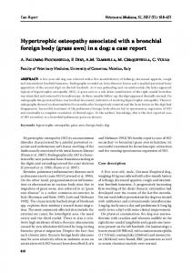
Fig. 1 a Johnsongrass (Sorghum halepense) patches in the Espabera maize field. The early detection of johnsongrass in maize crops represents a major challenge and serious complexity because both species are in the Poaceae family and show analogous spectral patterns,
an extraordinarily similar appearance and a parallel phenological evolution. b Spectral index values (ExG and NDVI for RGB and TTC sensors, respectively) for each class (weed, crop and bare soil)
Remote sensing using imagery from a satellite or a piloted airborne vehicle has been previously considered an effective technique to detect the weed patches in a late phenological stage of the crop (e.g. flowering). The images were used to design site-specific weed patch control at the field or broader scales against other worldwide problematic weeds such as wild oat and cruciferous (Castillejo-González et al. 2014; de Castro et al. 2012, 2013). Nevertheless, the imagery from these platforms lacked sufficient temporal and spatial resolution to detect weeds at the early phenological stage, because the suitable image resolution on the ground, i.e. pixel size or the ground sample distance (GSD) to achieve this objective must be 5 cm or less (Peña et al. 2015). Therefore, three of the most important variables to consider in the use of remote imagery for early weed mapping are the image spatial and spectral resolutions and the phenological stage of the crop and weeds. With higher spatial and temporal resolutions, the finer details can be discriminated in the images. Currently, the remote platforms that generate this high spatial resolution imagery are the unmanned aerial vehicles (UAVs, or drones or UASs, unmanned aerial systems) (Lopez-Granados 2011; Pajares 2015), which can embed sensors with different spectral ranges. As a result of flights conducted at low altitudes (