Figure 1: Architecture of Transport Management System without GPS/WiFi ... Figure 3 illustrates a model of the business processes covered in the case study.
Closed Loop Control of Soft Switched Forward Converter Using Intelligent Controller
67
IJCTA, 10(01), 2017, pp. 67-72 © International Science Press
Offline Remote Path Board Structure based on GPS/WiFi Location Access Akey Sungheetha* Mahalakshmi. K* Sherubha. P* Narmatha K* and Rajesh Sharma R** Abstract : Information technology (IT) has transformed many industries, from education to health care to government, and is now in the early stages of transforming transportation systems. Transportation faces many issues like high accidents rate in general, and much more rate in developing countries due to the lack of proper infrastructure for roads, is one of the reasons for these crashes. In this project we focus on public transportation vehicles - such as limitation mostly appear by consider off-shelf technologies such as WiFi, GPS and Open Street Maps (OSM). Keywords : ITS; GPS; WiFi; Transportation; OSM.
1.
INTRODUCTION AND ANALYSIS
Big Recently, different technologies have been deployed to assist and manage transportation. Many concentrated efforts in academia and industry point to a paradigm shift in intelligent transportation systems. Vehicles will carry computing and communication platforms, along with enhanced sensing capabilities. Transportation faces many issues like high accidents rate in general, and much more rate in developing countries due to the lack of proper infrastructure for roads, is one of the reasons for these crashes. The public transport system is a complex organizational and technological system by its structure, operation and management. Managing such a complex system cannot be efficiently done without the computerization of all processes in the system and data collection in order to create a reliable database. The issue of integrated management is one of the basic and most complex pre-conditions for effective and efficient public transport. This transport system is used to move, manage, control, copy development objects and customizing settings in an orderly fashion across SAP systems in a landscape through pre-defined transport routes (RFC Connections). A vehicle tracking system (VTS) can determine the location of a Vehicle using smartphone and displays the point on a map. In recent times, technologies like tracking vehicles have introduced some advanced features in many areas [3]. A GPS based vehicle tracking system merges the installation of a device in a vehicle, or a group of vehicles to enable the owner or collect data in the process from the field and also deliver it to the base of the operation. Technologies like GPS and GSM are used [4]. It includes the hardware part which comprises of GPS, GSM and software part is used for interfacing all the required modules. Main objective is to design a system that can be easily installed and also provide a platform for further enhancement. The location and time information anywhere on earth is provided by using GPS technology. * **
Department of IT KCE, Coimbatore, India Department of IT HICET, Coimbatore, India
68
Akey Sungheetha, Mahalakshmi. K, Sherubha. P, Narmatha K and Rajesh Sharma R
Nowadays, however, with technology growing rapidly, smart vehicle tracking system is being used in a variance to track and present location of vehicles in real-time. Our system proposes a vehicle tracking system using GPS technology accessible in a Smartphone application to provide better service and cost effective result for users [5]. 3
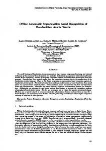
Public Fleet Vehicle
Incident reporting
Motorist Assistance Vehicles
Safety Management
4
Fire/Police Depts. Sheriff’s Office State Hwy. Patrol
Incident reporting
Maintenance resource request/response
1
Traffic Management Cols. Metro FMS City/Suburban TMC or Regional TMC
Roadway info. system data
Incident data/ traffic images Roadway
2
CCTV VMS Loops Figure 1: Architecture of Transport Management System without GPS/WiFi
In our project we will be developing a Smartphone application which can trace the region of the vehicle by using the GPS technique available in smart phones It faces a lot of issues like high accidents rate in general, and much more rate in developing countries due to the lack of proper infrastructure for roads, is one of the reasons for crashes. The main focus is on public transportation vehicles - such as buses, and mini-buses. The goal of the project is to design and deploy a smart/intelligent unit attached to public vehicles by using embedded microcontroller and sensors and empowering them to communicate with each other through wireless technologies [2]. The proposed Offline Intelligent Public Transportation Management System will play a major role in reducing risks and high accidents rate, whereas it can increase the traveler satisfactions and convenience. A vehicle tracking system (VTS) can determine the location of a Vehicle using smartphone and displays the point on a map. In recent times, technologies like tracking vehicles have introduced some advanced features in many areas [3]. A GPS based vehicle tracking system merges the installation of a device in a vehicle, or a group of vehicles to enable the owner or collect data in the process from the field and also deliver it to the base of the operation. Technologies like GPS and GSM are used [4]. It includes the hardware part which comprises of GPS, GSM and software part is used for interfacing all the required modules. Main objective is to design a system that can be easily installed and also provide a platform for further enhancement. The location and time information anywhere on earth is provided by using GPS technology.
Offline Remote Path Board Structure based on GPS/WiFi Location Access
2.
69
DESIGN AND IMPLEMENTATION
This execution deals with the new public transport management scheme. Description of the system’s architecture is provided. Emphasis is placed on the description of the communication system and data structure essential for the effectual and reliable public transport management. 3
Public Fleet Vehicle
Incident reporting
Motorist Assistance Vehicles
Safety Management
4
Fire/Police Depts. Sheriff’s Office State Hwy. Patrol
Incident reporting
Maintenance resource request/response
1
Traffic Management Cols. Metro FMS City/Suburban TMC or Regional TMC
Roadway info. system data
Incident data/ traffic images Roadway
GPS/WIFI, OPEN STREET MAPS
2
CCTV VMS Loops Figure 2: Architecture of Transport Management System with GPS/WiFi
The architecture shown in Figure 2 is executed with GPS/WiFi and open street map [1]. This implementation initiated a sortof cargo transportation management system combining RFID, GPS/WIFI indeed GPRS technologies and its functionalities are as trails: RFID is cast-off to record (into) the goods data; GPS is the orientation of the vehicle; GPRS is to broadcast the subsequent data information. Every functional module makes use of the vehicle-mounted computer to control. The assorted data was sent to remote control management center through the WIFI instead of GPRS. Thus, they can not only handle the loading of the goods successively, and also realize the orientation of the vehicle, which attains the target of discovering and dealt with the fault in time, enhancing the management of the cargo transport effectively and diminishing the time cost. We anticipate a method, software as well as a structure as enabling technologies for evaluation, planning and future enhancement the public transportation Scheme .At present, the demand for originating Offline public transportation management systems (PTMS) by means of GPS technologies have sharply amplified owing to the fact that, a well-designed PTMS will save human life by observing the driver behaviour which in turn will diminish number of times when the driver violate traffic regulations. This project initiates system composition structure and deliberates the system software and hardware design. Experiments projects that our scheme is practicable and effectual of data transmissions by means ofWiFi links, with contrast with the others management schemes grounded on WIFI devoid of GPRS and GPS technology, it is highly reduced the operating price.
70
Akey Sungheetha, Mahalakshmi. K, Sherubha. P, Narmatha K and Rajesh Sharma R
Figure 3 illustrates a model of the business processes covered in the case study. It signifies the business processes of a freight forwarding company, in which up to three smaller shipments from suppliers are consolidated and in turn shipped together to customers. The business process is structured into incoming and outgoing transport legs, which unitedly attempts at ensuring that freight is timely delivered to customers [6]. C2K Workflow Incoming Transport Leg 1
RCS
DEP
RCF
DLV
Incoming Transport Leg 2
RCS
Outgoing Transport Leg
DEP
RCF
DLV
RCF
DLV
RCS
DEP
RCF
DLV
Incoming Transport Leg 3
RCS
DEP
Figure 3: Transport and Logistics Process used in Case Study
Each of the transport legs comprises the subsequent physical transport services: • RCS: Check in freight at departure airline. Shipment is checked in and a receipt is produced at departure airport. • DEP: Confirm goods on board. Aircraft has departed with shipment on board. • RCF: Accept freight at arrival airline. Shipment is checked in according to the documents and stored at arrival warehouse. • DLV: Deliver freight. Receipt of shipment was signed at destination airport. The control algorithm selects only the electric motor as long as the battery state of charge (SOC) is greater than a threshold value. Once the SOC reduces below this value, the control algorithm switches to charge sustaining (PHEV behaving like a HEV). In blended mode control, the objective is to achieve lower limit of SOC only at the end of trip. The battery SOC is reduced slowly throughout the trip, and the SOC profile followed in this control can be optimally selected by principles from optimization theory, like dynamic programming. This method can provide better fuel economy, but at the cost of higher information requirement [7].
Shipment
0-20000
20000-40000
3667
3385
3103
2821
2539
2257
1975
1693
1411
1 283 565 847 1129
60000 40000 20000 0
40000-60000
Figure 4: Transport and Shipment Process
nr
Offline Remote Path Board Structure based on GPS/WiFi Location Access
71
A transport leg in Figure 4 may involve multiple segments (e.g., transfers to other flights or airlines). In those cases, activity RCF loops back to DEP (indicated by the “loop-back” arrow in Figure 1). In the case study, the number of segments per leg ranges from one to four.
Departure
0-20000
20000-40000
3649
3345
3041
2737
2433
1825
2129
1 305 609 913 1217 1521
60000 40000 20000 0 i1_legid
40000-60000
Figure 5: Transport and Shipment Process
The transport services in Figure 5 are denoted by three-letter acronyms according to the Cargo 2000 industry standard. Cargo 2000 is an initiative of IATA (the International Air Transport Association). It aims at delivering a new quality management system for the air cargo industry. Cargo 2000 allows for unprecedented transparency in the supply chain. Stakeholders involved in the transport process can share agreed Cargo 2000 messages, comprising transport planning, replanning and service completion events. Cargo 2000 is based on the following key principles: (1) Every shipment gets a plan (called a route map) describing predefined monitoring events. (2) Every service used during shipment is assigned a predefined milestone with a planned time of achievement. (3) Stakeholders receive alerts when a milestone has failed and notifications upon milestone completion, which include the effective time the milestone has been achieved.
Shipment and Departure
0-20000
20000-40000
3649
3345
3041
2737
2129 2433
1825
1 305 609 913 1217 1521
60000 40000 20000 0 i1_legid
40000-60000
Figure 6: Transport and Shipment Process
The case study in Figure. 6 data comprises tracking and tracing events from a forwarding company’s Cargo 2000 system for a period of five months. From those Cargo 2000 messages, we reconstructed execution traces of 3,942 actual business process instances, comprising 7,932 transport legs and 56,082 service invocations. Each execution trace includes planned and effective durations (in minutes) for each of the services of the business process (introduced in Section II), as well as airport codes for the DEP (“departure”) and RCF (“arrival”) services. Due to the fact that handling of transport documents along the business process differs based on whether the documents are paper-based or electronic, we focus on the flow of physical goods, as our data set did not allow us to discern the different document types.
72
Akey Sungheetha, Mahalakshmi. K, Sherubha. P, Narmatha K and Rajesh Sharma R
The rebuilding procedure elaborate the information cleanliness and anonymization. The clean coinciding and partial Cargo 2000 messages, detach invalid transports (i.e., removed path maps), cleaned for omissions from the C2K scheme (such as trials taking place in advance path map creation) and standardized the method information was signified in dissimilar message types. Finally, due to confidentiality reasons, message fields which might exhibit business critical or customer-related data (such as airway bill numbers, flight numbers and airport codes) have been eliminated or masked.
3.
CONCLUSION
In the proposed scheme, the Open Street Maps plays a major rule during observation, graphical presentation and finding the extreme acceptable speed for each road sector along with the traveled route. Enduring effort is to enable the system for assisting connected tracking and observing facilities, by means of mobile information systems. The scheme even however can be as complete or fragments can be realistic all over the domain, mostly target the developing countries. This limitation mostly appears by reflecting off-shelf technologies such as Wi-Fi, GPS and OSM. In the proposed system, the Open Street Maps shows a key part throughout checking, picturing and recognizing the extreme acceptable speed for each road sector along with the traveled route.
4.
REFERENCES 1. Tarapiah, Saed, and Shadi Atalla. “Public Transportation Management System based on GPS/WiFi and Open Street Maps.” Editorial Preface 6.1 (2015). 2. Tarapiah, Saed, et al. “Offline public transportation management system based on GPS/WiFi and open street maps.” Computational Intelligence, Communication Systems and Networks (CICSyN), 2014 Sixth International Conference on. IEEE, 2014. 3. Tarapiah, Saed, Shadi Atalla, and Rajaa AbuHania. “Smart on-board transportation management system using gps/ gsm/gprs technologies to reduce traffic violation in developing countries.” International Journal of Digital Information and Wireless Communications (IJDIWC) 3.4 (2013): 430-439. 4. Popa, Mircea, and Bogdan Suta. “A solution for tracking a fleet of vehicles.” Telecommunications Forum (TELFOR), 2011 19th. IEEE, 2011. 5. Tarapiah, Saed, Rajaa AbuHania, and Diana Jamal Islam Hindi. “Applying web based gps/gprs ticketing and tracking mechanism to reduce traffic violation in developing countries.” The International Conference on Digital Information Processing, E-Business and Cloud Computing (DIPECC2013). The Society of Digital Information and Wireless Communication, 2013. 6. A. Metzger, P. Leitner, D. Ivanovic, E. Schmieders, R. Franklin, M. Carro, S. Dustdar, and K. Pohl, “ Comparing and combining predictive business process monitoring techniques,” IEEE Trans. on Systems Man Cybernetics: Systems, 2014. 7. J. Suganthi Akey Sungheetha, “” Energy Saving Optimized Polymorphic Hybrid Multicast Routing Protocol.” International Review on Computers and Softwares, Vol.8, No.6, pp. 1367 – 1373.