Temp-O-Map: Ontology-based Search and Visualization of Spatio-Temporal Maps Tomi Kauppinen
Christine Deichstetter
University of Helsinki and
Johannes Kepler Universität Linz and
Helsinki University of Technology (TKK) Media Technology
Helsinki University of Technology (TKK)
Semantic Computing Research Group (SeCo)
[email protected]
http://www.seco.tkk.fi/
[email protected]
Eero Hyvönen Helsinki University of Technology (TKK) and University of Helsinki Semantic Computing Research Group (SeCo) http://www.seco.tkk.fi/
[email protected]
Abstract Geographic knowledge is essential in handling a large variety of resources, including cultural contents such as museum artifacts, maps, books, photographs, and videos. The metadata of such resources often need to refer to geographic entities or regions, both modern and historical ones overlapping each other on the map. For example, a cultural artifact may have been produced, used or found in a historical place that does not exist any more on a modern map. This paper presents Temp-O-Map, a system by which the user can search for places of different times modeled by an underlying historical place ontology of Finland. The idea is to use transparent overlaying maps, a historical one showing old place names and topology and a modern one (Google Maps) showing current maps or satellite images. By Temp-O-Map the user can find historical and modern places on the map and understand their spatio-temporal relation in the world. The system is being integrated as a service in the semantic portal CultureSampo—Finnish Culture on the Semantic Web.
1 Introduction A large proportion of cultural resources such as artifacts, collections, books, photographs, and videos are geographically referenced and thus should be identified by search terms that refer to locations (Jones et al., 2001; Stuckenschmidt and Harmelen, 2004). This is because they are produced, found or used in those locations, or they have some other relationship to the location in question. However, geographic regions change over time. Regions, for example, are split and merged due to various reorganizations at the political, social and cultural levels. To address the problem of change we developed an ontological method (Kauppinen and Hyvönen, 2007, 2005) for representing spatiotemporal changes in regions that essentially define a historical geo-ontology time series.
In this paper we present the Temp-O-Map1 system to demonstrate how an ontology time-series together with mash-up technologies can be used for finding geographical and other information from different eras.
2
Visualization and Search using Multiple Simultaneous Maps
In order to visualize historical geo-content annotated according to old temporal regions and place names, historical maps are needed. On the other hand, also the current view of places is usually needed at the same time to bridge the conceptual cap between regions of different eras. To facilitate this, we created 1 http://demo.seco.tkk.fi/geo/temp-o-map/
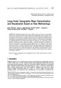
Figure 1: Using multiple maps simultaneously. A historical Karelian map depicting the city of Viipuri is shown semi-transparently on top of a modern satellite image provided by the Google Maps service.
a scheme for using several overlaying maps simultaneously in visualizations. Using layers is a common (de Berg et al., 2000) way for visualizing spatial data and for making it more readable. Regions change over time and hence each temporal region in the system has an own identifying URI. This means that if the area of a region changes, there will be a new URI corresponding to a new region with the new value for the essential properties, such as the size and central point of that region. The maps and satellite images of the Google Maps service were used as the contemporary view. To provide the historical view, we used a set of old Finnish maps from the early 20th century covering the area of the annexed Karelia region before the World War II. The maps were digitized and provided by the National Land Survey of Finland2 . In addition, a geological map of the Espoo City region in 1909, provided by the Geological Survey of Finland3 , was used. Figure 2 illustrates our scheme. On the right, a contemporary satellite Google Maps image of the city of Viipuri in the Karelia region is shown. In the middle, a smaller rectangular area is shown with a semitransparent4 old Karelian map that is positioned correctly and is of the same scale as the Google Maps 2 http://www.maanmittauslaitos.fi/default.asp?site=3 3 http://en.gtk.fi 4 We
use transparency libraries provided by http://www.kokogiak.com/ which allow the alteration of the level of transparency.
image. This smaller view shows the old Viipuri, an old Finnish city that nowadays is a part of Russia. The place cannot be found in current maps as it was, which makes it difficult for modern users to locate the place geographically. Old maps and names on it could be of substantial benefit when using the visualization in annotating or searching content by maps in cultural heritage systems such as CultureSampo (Hyvönen et al., 2006). The simultaneous views are useful also when comparing geo-information from different eras (e.g., how construction of cities has evolved) or from different thematic perspectives (e.g., viewing a geological map on top of a satellite image). In order to move around the user is able to use the zooming and navigation functions of Google Maps and the Karelian view is automatically scaled and positioned accordingly. Places can also be found by selecting one in a drop-down menu on the left. Furthermore, the user can formulate a search query as a polygon by pointing out n points on a map. All the places that have a central point inside that polygon are retrieved and a user is able to explore the temporal maps concerning them.
Acknowledgments Our research is a part of the National Semantic Web Ontology Project in Finland5 (FinnONTO) 20032007 funded mainly by the Finnish Funding Agency for Technology and Innovation (Tekes).
References Mark de Berg, Marc van Kreveld, Mark Overmars, and Otfried Schwarzkopf. Computational geometry: algorithms and applications. Springer-Verlag New York, Inc., Secaucus, NJ, USA, second edition, 2000. Eero Hyvönen, Tuukka Ruotsalo, Thomas Häggström, Mirva Salminen, Miikka Junnila, Mikko Virkkilä, Mikko Haaramo, Tomi Kauppinen, Eetu Mäkelä, and Kim Viljanen. CultureSampo— Finnish culture on the Semantic Web: The vision and first results. In Semantic Web at Work — Proceedings of the 12th Finnish Artificial Intelligence Conference STeP 2006, volume 1, Helsinki, Finland, 2006. Christopher B. Jones, Harith Alani, and Douglas Tudhope. Geographical information retrieval with 5 http://www.seco.tkk.fi/projects/finnonto/
ontologies of place. In In Proceedings of the International Conference on Spatial Information Theory, pages 322–355. Springer-Verlag, 2001. Tomi Kauppinen and Eero Hyvönen. Modeling coverage between geospatial resources. In Posters and Demos at the 2nd European Semantic Web Conference ESWC2005, pages 49–50, Heraklion, Crete, 2005. Tomi Kauppinen and Eero Hyvönen. Modeling and Reasoning about Changes in Ontology Time Series, chapter 11 in Ontologies: A Handbook of Principles, Concepts and Applications in Information Systems, pages 319–338. Integrated Series in Information Systems. Springer-Verlag, New York (NY), New York, NY, 2007. Heiner Stuckenschmidt and Frank Van Harmelen. Information Sharing on the Semantic Web. SpringerVerlag, Berlin Heidelberg, New York, 2004.