From St Paul’s to the Tate Modern; Overcoming Problems in Monitoring Bridge Deflections Using GPS Gethin ROBERTS, Xiaolin MENG and Chris BROWN, United Kingdom
Key words: Structural deformation, deflection, GPS, accelerometer, pseudolite
SUMMARY A series of trials were conducted upon the Millennium Bridge in London during the 22 to 24 November 2000. These trials consisted of monitoring the deflections of the Bridge using three GPS receivers, and an accelerometer, over a period in total of 11 hours. The results were processed and filtered in an attempt to show that GPS could be used in such an environment to monitor deflections. The results illustrated, however, that due to the satellite constellation in the UK; a large void exists from the zenith to the horizon in a northerly direction. This void and lack of GPS satellites within it results in a poor NDOP, resulting in poor North-South precision. The phenomena was evident in the Bridge results. A GPS data simulator, developed at the IESSG, was then used to re-create the Bridge data, and subsequently pseudolite data simulated into the same. The results illustrate that if a pseudolite had been used on the day of the field trials; the results could well have been improved upon.
1/11 Session 8 Frequencies and Cyclic Monitoring of Structures Gethin Roberts, Xiaolin Meng and Chris Brown TS8.1 From St Paul’s to the Tate Modern; Overcoming Problems in Monitoring Bridge Deflections Using GPS 1st FIG International Symposium on Engineering Surveys for Construction Works and Structural Engineering Nottingham, United Kingdom, 28 June – 1 July 2004
From St Paul’s to the Tate Modern; Overcoming Problems in Monitoring Bridge Deflections Using GPS Gethin ROBERTS, Xiaolin MENG and Chris BROWN, United Kingdom
1. INTRODUCTION GPS is widely used in precise engineering applications, such as landslide monitoring, construction plant control and structural deformation monitoring. In these applications, uniform three-dimensional positioning precision in a local coordinate system is required. Some of these applications have specific precision requirements in the vertical direction, for example when analyzing land subsidence, while others are concerned with the north or east direction such as evaluating the structural deformations caused by wind loading. It is important to analyze the achievable positioning precision with the current GPS constellation and potential augmentation techniques for such engineering applications. The Millennium Bridge in London was completed in 2000, linking St Paul’s with the Tate Modern Gallery. The footbridge is a shallow suspension bridge with cables below the deck allowing pedestrians unobstructed views of the surrounding areas. The bridge has spans of 81m, 144m and 108m. During its opening on the 10 June 2000, a sponsored walk was organized during which a maximum of 2,000 people were walking over the bridge at any instance. It is thought that due to the people walking close to each other, they would naturally walk in step. This large additional weight and force on the bridge resulted in greater than expected movements. The bridge was subsequently closed for the installation of dampers to prevent such future movements. Today, the Bridge is fully operational and is a major tourist attraction. During this closure, and prior to the refurbishment, staff from the IESSG were allowed to conduct trials upon the bridge in order to assess whether GPS could in fact be used to monitor the deflections of such a structure. During the 22 to 24 November 2000 a series of trials were conducted upon the bridge, this being a viability trial for such monitoring. The following paper details the trials and some of the outcomes, one of which illustrates that the GPS constellation results in noise that could initially imply that movements exist when in fact they don’t. 2. THE TRIALS The viability trials conducted on the 22 to 24 November 2000 consisted of clamping three Leica AT504 choke ring antennas, connected to SR530 dual frequency GPS receivers, upon the bridge at pre-defined locations. A reference Leica SR530 GPS receiver with an AT 504 2/11 Session 8 Frequencies and Cyclic Monitoring of Structures Gethin Roberts, Xiaolin Meng and Chris Brown TS8.1 From St Paul’s to the Tate Modern; Overcoming Problems in Monitoring Bridge Deflections Using GPS 1st FIG International Symposium on Engineering Surveys for Construction Works and Structural Engineering Nottingham, United Kingdom, 28 June – 1 July 2004
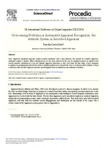
choke ring antenna was placed upon an adjacent building. The GPS data was gathered at a rate of 10Hz for post processing. The reference station’s coordinates were established through processing all the data gathered relative to Ordnance Survey active stations located around London. In addition to the GPS receivers, a Kistler tri-axial accelerometer was also used at one of the Bridge GPS locations, gathering data at a rate of 200 Hz. One of the Bridge’s GPS receivers was co-located with the accelerometer throughout the trials, whilst the other two GPS receivers spent their time between 4 further locations upon the Bridge. The locations and sessions are illustrated in Figure 1 and table 1. All the data was gathered and periodically downloaded for post processing.
Figure 1: The locations of the Bridge’s Monitoring Stations
In all, 11 hours of GPS data were gathered at a rate of 10Hz, and 4 hours of accelerometer data at a rate of 200Hz. This resulted in 1.98 million points and 2.88 million points respectively. During the trials there were sporadic passengers upon the bridge, consisting of construction workers and the researchers. However, there was no significant pedestrian loading applied to the Bridge during the trials. The GPS post processing was carried out using both Leica’s SKIPRO and the IESSG’s Kinpos. Figures 2 and 3 illustrate the reference GPS receiver and one of the Bridge’s monitoring stations respectively.
3/11 Session 8 Frequencies and Cyclic Monitoring of Structures Gethin Roberts, Xiaolin Meng and Chris Brown TS8.1 From St Paul’s to the Tate Modern; Overcoming Problems in Monitoring Bridge Deflections Using GPS 1st FIG International Symposium on Engineering Surveys for Construction Works and Structural Engineering Nottingham, United Kingdom, 28 June – 1 July 2004
Date
Session No
Start Time
End Time
Antenna Location
22/11/00
1 1 1 1
14.35.42 14.36.03 14.35.52 15.08.12
16.25.52 16.24.58 16.25.26 16.08.14
A B C B (accelerometer)
23/11/00
2 2 2
09.51.23 09.38.25 09.38.58
12.13.26 12.13.37 12.13.22
B C D
3 3 3 3 3
12.37.24 12.39.24 12.37.57 12.42.08 13.46.26
14.50.04 14.50.21 14.50.13 13.42.10 14.46.28
B C A B (accelerometer) B (accelerometer)
4 4 4
15.14.24 15.16.23 15.15.24
16.47.12 16.47.17 16.47.28
B C A
5 5 5 5
08.56.09 09.05.15 09.15.28 09.04.35
12.06.13 12.06.36 12.07.20 10.04.38
B D E B (accelerometer)
24/11/00
Table 1: Data recording session times
Figure 2 and 3: The Reference SR530 GPS receiver (left), and a GPS receiver and Kirstler Accelerometer (right)
3. INITIAL RESULTS The results presented below are very much a subset of the results obtained. Once the GPS data was post processed, the initial task was to convert the results from GPS coordinates into bridge coordinates. This was conducted by knowing orientation of the bridge in WGS84, derived from the coordinates of two GPS stations along the length of the bridge. The Bridge runs in an almost North-South direction. The lateral direction is that across the Bridge’s span and the longitudinal is that along its length.
4/11 Session 8 Frequencies and Cyclic Monitoring of Structures Gethin Roberts, Xiaolin Meng and Chris Brown TS8.1 From St Paul’s to the Tate Modern; Overcoming Problems in Monitoring Bridge Deflections Using GPS 1st FIG International Symposium on Engineering Surveys for Construction Works and Structural Engineering Nottingham, United Kingdom, 28 June – 1 July 2004
Figures 4, 5 and 6 illustrate some of the initial results; these are simply the results from the processing software converted into Bridge coordinates. 20
10
Displacement (mm)
0
-10
-20
-30
-40 400300
400500
400700
400900
401100
401300
401500
401700
401900
402100
402300
401500
401700
401900
402100
402300
GPS Time (s)
Figure 4: Unfiltered lateral deflections 20
10
Displacement (mm)
0
-10
-20
-30
-40 400300
400500
400700
400900
401100
401300 GPS Time (s)
Figure 5: Unfiltered Longitudinal deflections
5/11 Session 8 Frequencies and Cyclic Monitoring of Structures Gethin Roberts, Xiaolin Meng and Chris Brown TS8.1 From St Paul’s to the Tate Modern; Overcoming Problems in Monitoring Bridge Deflections Using GPS 1st FIG International Symposium on Engineering Surveys for Construction Works and Structural Engineering Nottingham, United Kingdom, 28 June – 1 July 2004
30
20
Displacement (mm)
10
0
-10
-20
-30 400300
400500
400700
400900
401100
401300
401500
401700
401900
402100
402300
GPS Time (s)
Figure 6: Unfiltered vertical deflections
4. DIGITAL SIGNAL PROCESSING A preliminary step was to filter out any noise using a moving average filter. Various filter lengths were investigated. A selection of three filtered data sets are illustrated in Figures 7 and 8. 25 lateral east long'l east vertical east lateral west long'l west vertical west
20 15
displacement (mm)
10 5 0 -5 -10 -15 -20 -25 0
200
400
600
800
1000
1200
1400
1600
1800
2000
seconds
Figure 7: 20 second filter applied to the two midspan GPS receivers’s deflections
6/11 Session 8 Frequencies and Cyclic Monitoring of Structures Gethin Roberts, Xiaolin Meng and Chris Brown TS8.1 From St Paul’s to the Tate Modern; Overcoming Problems in Monitoring Bridge Deflections Using GPS 1st FIG International Symposium on Engineering Surveys for Construction Works and Structural Engineering Nottingham, United Kingdom, 28 June – 1 July 2004
25 lateral east long'l east vertical east lateral west long'l west vertical west
20 15
Displacement (mm)
10 5 0 -5 -10 -15 -20 -25 0
200
400
600
800
1000
1200
1400
1600
1800
2000
seconds
Figure 8: 5 second filter applied to the two midspan GPS receivers’s deflections
It can be seen in Figure 8 that there is good agreement between the two GPS receivers, these were located on opposite sides of the Bridge’s midspan centre. The results not only show a displacement, but also the frequency of the deflections may also be derived from these results (Brown et al, 1999.) Initial analysis, however, suggested that the longitudinal deflections of the Bridge were in fact larger than those in the lateral direction. Figure 9 illustrates a 24 hour sky plot for the millennium Bridge, showing that there is never a GPS satellite due north of the survey site. This will have implications in the NDOP, resulting in the East-West component being of the highest quality, followed by North- South then the vertical component. Upon further analysis, however, it was concluded that the geometry of the GPS satellites would introduce noise into the GPS coordinates in the North-South component. Bridge movements in the lateral and vertical directions might be expected, whereas any significant longitudinal movements would be unexpected.
7/11 Session 8 Frequencies and Cyclic Monitoring of Structures Gethin Roberts, Xiaolin Meng and Chris Brown TS8.1 From St Paul’s to the Tate Modern; Overcoming Problems in Monitoring Bridge Deflections Using GPS 1st FIG International Symposium on Engineering Surveys for Construction Works and Structural Engineering Nottingham, United Kingdom, 28 June – 1 July 2004
Figure 9: a 24 hour sky plot of GPS satellites over the Millennium Bridge
5. PSEUDOLITES The trials illustrated a problem when trying to use GPS for such precise deflection monitoring. At the time, there was some research being conducted into the integration of pseudolite data in order to enhance GPS (Liwen et al, 2001, Choi et al, 2000). A pseudolite is basically a pseudo-satellite; a ground based GPS data source, in effect a ground based GPS satellite. The pseudolites can be programmed to transmit C/A codes for any PRN on an L1 carrier wave. Certain GPS receivers can be programmed to receive these spare PRN code and carrier phase values. This was the impetus for the IESSG to begin its research into pseudolites, with a particular application for deformation and deflection monitoring. Figure 10 shows a pseudolite being used during collaborative trials with the University of New South Wales. However, research into pseudolite data would not allow the GPS data already gathered to be improved. Instead, it was decided to simulate pseudolite data into the results to see whether or not an improvement would have been feasible if pseudolites would have been sued during the trials. The IESSG has developed a GPS data simulator that will output RINEX GPS data for a receiver at a given location and time. The simulator was used to re-create the original bridge data, the results of which compared well with the real bridge data. The simulated longitudinal results were larger than the lateral results. This showed the simulator to be able to create GPS data correctly. Figure 11 illustrates the simulated results.
8/11 Session 8 Frequencies and Cyclic Monitoring of Structures Gethin Roberts, Xiaolin Meng and Chris Brown TS8.1 From St Paul’s to the Tate Modern; Overcoming Problems in Monitoring Bridge Deflections Using GPS 1st FIG International Symposium on Engineering Surveys for Construction Works and Structural Engineering Nottingham, United Kingdom, 28 June – 1 July 2004
Figure 10: A GPS pseudolite being used during trials at the University of Nottingham (left) and Parsley Bay, Sydney, Australia (right) 3D Simulated Relative Movements of a Suspension Bridge with 0 Degree Orientation Angle Offset from North (BCS) 0.1 Up
Relative Movement (m)
0.08
Long
Lat
0.06 0.04 0.02 0 -0.02 -0.04 -0.06 -0.08 -0.1 315440
315450
315460
315470
315480
315490
315500
GPS Time (second)
Figure 11: the GPS only simulated results
The next step was to introduce code and carrier data from a stationary satellite located at a pre defined location within the simulation i.e. a pseudolite. All the data produced from the simulator, in RINEX format, were then processed using Kinpos. At this stage no weighting was used for the pseudolites within the processing. The simulation was used purely as a means to evaluate whether pseudolites could be a feasible way to improve such a scenario. Figures 12 and 13 illustrate the Bridge data with the introduction of one and two pseudolites respectively.
9/11 Session 8 Frequencies and Cyclic Monitoring of Structures Gethin Roberts, Xiaolin Meng and Chris Brown TS8.1 From St Paul’s to the Tate Modern; Overcoming Problems in Monitoring Bridge Deflections Using GPS 1st FIG International Symposium on Engineering Surveys for Construction Works and Structural Engineering Nottingham, United Kingdom, 28 June – 1 July 2004
Simulated Relative Movements with One Pseudolite along Both Bridge Axis Side (London) 0.008 Up
Long
Lat
Relative Movement (m)
0.006 0.004 0.002 0 -0.002 -0.004 -0.006 -0.008 315000
315100
315200
315300
315400
315500
315600
Figure 12: Simulated GPS results with one pseudolite Simulated Relative Movements with Two Pseudolites on Both Bridge Axis Side (London) 0.008 Up
Long
Lat
Relative Movement (m)
0.006 0.004 0.002 0 -0.002 -0.004 -0.006 -0.008 315000
315100
315200
315300
315400
315500
315600
Figure 13: Simulated GPS results with two pseudolites
It can be seen that the introduction of the pseudolites dramatically improves the results in both the North direction as well as in the vertical. 6. CONCLUSIONS GPS satellite geometry and its implications for precise deformation monitoring have been discussed in this paper. It has been shown that the North component of the GPS results in the UK are worse in precision than Eastings. The simulation of a pseudolite into the data shows that it is indeed feasible to improve these results.
10/11 Session 8 Frequencies and Cyclic Monitoring of Structures Gethin Roberts, Xiaolin Meng and Chris Brown TS8.1 From St Paul’s to the Tate Modern; Overcoming Problems in Monitoring Bridge Deflections Using GPS 1st FIG International Symposium on Engineering Surveys for Construction Works and Structural Engineering Nottingham, United Kingdom, 28 June – 1 July 2004
ACKNOWLEDGEMENTS The authors are grateful to Arup for allowing access to the Bridge. In addition, The University of Nottingham for funding the trials. REFERENCES Brown, C J; Karuna, R; Ashkenazi, V; Roberts, G W; Evans, R;Monitoring of Structures using GPS, Proc Institution of Civil Engineers, Structures, ISSN 0965 092X, pp 97 105, February 1999. CHOI, I.K., WANG, J., HAN, S., & RIZOS, C., 2000. Pseudolites: a new tool for surveyors? 2nd Trans Tasman Survey Congress, Queenstown, New Zealand, 20-26 August, 141149. Liwen Dai, Jinling Wang, Chris Rizos, and Shaowei Han; Applications of Pseudolites in Deformation Monitoring Systems, Proc - Deformation Measurements and Analysis, 10th INTERNATIONAL SYMPOSIUM ON DEFORMATION MEASUREMENTS, INTERNATIONAL FEDERATION OF SURVEYORS (FIG), Commission 6 Engineering Surveys, Working Group 6.1, Orange, California, USA 19 - 22 March 2001. CONTACTS Dr Gethin Roberts IESSG The University of Nottingham University Park Nottingham NG7 2RD UNITED KINGDOM Tel. + 44 115 951 3933 Email:
[email protected]
11/11 Session 8 Frequencies and Cyclic Monitoring of Structures Gethin Roberts, Xiaolin Meng and Chris Brown TS8.1 From St Paul’s to the Tate Modern; Overcoming Problems in Monitoring Bridge Deflections Using GPS 1st FIG International Symposium on Engineering Surveys for Construction Works and Structural Engineering Nottingham, United Kingdom, 28 June – 1 July 2004