Intemet/Intranet we introduce the main principles of this technology. .... can handled only in a standard webbrowser with extended functionality (e.g. plug-in).
UNCLASSIFIED
Defense Technical Information Center Compilation Part Notice ADPO10874 TITLE: Principles and Application of Geographic Information Systems and Internet/Intranet Technology DISTRIBUTION: Approved for public release, distribution unlimited
This paper is part of the following report: TITLE: New Information Processing Techniques for Military Systems [les Nouvelles techniques de traitement de l'information pour les systemes
militaires] To order the complete compilation report, use: ADA391919 The component part is provided here to allow users access to individually authored sections f proceedings, annals, symposia, ect. However, the component should be considered within
he context of the overall compilation report and not as a stand-alone technical report. The following component part numbers comprise the compilation report: ADP010865 thru ADP010894
UNCLASSIFIED
10-1
Principles and Application of Geographic Information Systems and Internet/Intranet Technology Prof. Dr.-Ing. Wolfgang Reinhardt Wolfaang.Reinhardt( unibw-muenchen.de http://agis.bauv.unibw-muenchen.de/staff/reinhardt/home.htm University of the Federal Armed Forces Munich Institute for Geo Information and Land Development Werner-Heisenberg-Weg 39 D-85577Neubiberg Germany key words: GIS, Internet/Intranet
Abstract The paper presented consists of three main parts. In the first part we roughly outline the state of the art of Geographic Information Systems (GIS) mainly with respect to technology and data. Within this part we also give some examples where GIS is applied in military applications. The second part gives an overview of architectures and some technical aspects of GIS-Intemet/Intranet solutions, compares the different approaches and discusses the potential of this technology in general. Furthermore some examples demonstrate the practical use of GIS and Internet/Intranet. As the World Wide Web (WWW) gains more and more significance and there is a large demand of GIS applications in the Intemet/Intranet we introduce the main principles of this technology. Especially we explain how Geographic Information Systems can be connected to the world wide web and which extensions are necessary to transfer and to view Geographic data. In this part we also show how the Virtual Reality Modelling Language (VRML) can be used in this field. Part of this is based on results of some projects conducted for the AMilGeo (Amt ffir Militdrisches Geowesen) of the German Federal Armed Forces as well as on other civilian projects. In the third part of the paper we demonstrate the potential of the GIS and Internet/Intranet technology for civilian and military applications. Besides we discuss the main advantages of GIS and Internet/Intranet, such as Ease of Use or the possibility to access up-to-date information in various databases. Furthermore we show how the connection of Internet and telecommunication can be used in GIS.
1
State of the art of Geographic Information Systems
Geographic Information Systems are Information Systems which are extended to handle geographic data which often also is called spatial data. That means a GIS in addition to the common IS functionality offers specific data types, data access methods and spatial data analysis methods. Due to the fact that more than 80% of all data are somehow related to a geographical position GIS is used in very many fields today, civilian and military too. Geographic Information Systems consist of hardware, software and data. As hardware platform today standard PCs are used. GIS software packages are offered from more than 500 companies world-wide, but about ten of the most important vendors share more than 60% of the market. Data is not only the most important part of a GIS but also the most costly factor. This is due to the generally high costs of data
Paperpresented at the RTO IST Swyposiurn on "New Information Processing Techniques for Military Systems", held in Istanbul, Turkey, 9-11 October 2000, and published in RIO AIP-049.
10-2
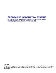
acquisition. Figure 1 depicts the approximately cost relation of hardware, software and data which has been verified in various projects. These days GIS data is available in many countries, often countrywide and in various forms.
1 Data
U Software SHardware
0
20
40
60
80
100
Figure 1: Cost relation of hardware, software and data in a GIS
1.1
Technology and trends
From a technical point of view we can state that state of the art GIS hardware and software are standard IT products. Some of the important points:
"* GIS support the client / server architecture. Often in a GIS a standard data base is included. These data bases are mostly relational data bases. Object oriented data bases are used very seldom
"* The programming languages used are mainly C++ or Java, for customising purposes also Visual Basic
"* Internet/Intranet technology has become a key factor in GIS during the last years (for details see
"*
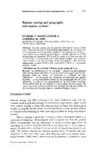
chapter 2). This technology enables the introduction of GIS based services which can be used in Intranets and in the Internet. For these services recently also eCommerce techniques and products have been utilised. Based on the connection of Internet and telecommunication new services have been introduced which can be used in principal from mobile phones and other mobile equipment ('mCommerce applications'). Mainly so called location based services are discussed widely nowadays. These services e.g. allow for queries to show the way to a point of interest (see figure 2)
More information to these items are given in the contributions in [Reinhardt, 2000]
Figure 2: Example of a location based service
10-3
1.2
Interoperability
As already mentioned there is a large number of data sets available in most countries of the world. These data sets are available mainly on state, county or community level as well as on enterprise level. These GIS in general have been designed in a proprietary manner based on proprietary systems. Due to this fact data exchange or integration without loosing information is not easy. For this reason several activities have been started during the last decade which are aiming on an improvement of this situation. The most remarkable activities - from the point of view of the author - are the activities of the
"* International Standardisation Organisation (ISO), TC 211 [http://www.statkart.no/isotc211/] and the "* Open GIS Consortium (OGC) [http://www.opengis.org] The activities of the OGC are consequently following the idea of interoperability of geographic information. OGC and ISO are working together very closely ('first class liaison'). E.g. OGC uses ISO specifications (international standards, draft international standards) within their development process to produce implementation specifications. Because of the strong impact of OGC work on GIS in general it shall be outlined roughly: The Open GIS Consortium has been founded as a non profit organisation in 1994 in the US. The consortium now has more than 200 members. All relevant computer hardware, data base and GIS vendors as well as other IT companies, consulting companies, GIS data providers and users firom all over the world are working in OGC. The aim is to allow for a interoperability of GIS data without any loss of information. For that goal abstract and implementation specifications are produced in working groups which are in general implemented by the vendors within their GIS software. OGC's work of the last two years is strongly focused on the use of internet technology. Roughly speaking the idea of interoperability can be reached in two ways: By direct access to distributed data bases (on-line) over common networks. For this purpose standard access methods are defined which are published on OGC's homepage. By means of file transfers (off-line). For this purpose standard data description languages are defined and used respectively. With these languages data schemes and the data itself can be described. The file can be transferred via networks like the internet, of course. The approach of the second way is outlined now shortly: In this approach GIS features are described in a specific language, the OpenGIS Geography Markup Language (GML). This GML is based on the well known XML language of the w3 consortium [http://www.w3.org/]. More information on GML can be found at [https://feature.openeiis.ori-/fc 11!GMLRFCV1 0.htrnl] With this approach the geographic data is transferred in ASCI files. The representation of a point is like the following:
10-4