Quantified soil dynamics and spatial fragmentation within the shifting agricultural landscape in southern Cameroon Martin YemefackA*, Rosaline NjomgangA, Laurent NounamoA, and David G. RossiterB A
Institute of Agricultural Research for Development (IRAD), P.O. Box 2067 Yaoundé-Cameroon. E-mail:
[email protected] and
[email protected];
[email protected];
[email protected] B Faculty of Geo-Information Science and Earth Observation (ITC), University of Twente, P.O. Box 6, 7500 AA Enschede, The Netherlands Email:
[email protected] * Corresponding author, Tel: (237) 94144812 / 22015826, E-mail:
[email protected] and
[email protected]
Abstract This research used scientific modeling tools to produce quantitative information on the effects of shifting agriculture on soil and spatial pattern of landscape dynamics in the area. An analysis of farming system led to the development of a conceptual model of the spatio-temporal dynamics of shifting agriculture, including transition matrices of rotational cycles. The study of soil variability showed that 30-35% of the total variance of some topsoil (0-20 cm) properties was due to the influence land use practices. A robust quantitative multi-criteria method was then developed that selected five soil properties (pH, calcium, available phosphorus, bulk density and organic carbon) that are the most sensitive to these agricultural practices. Empirical models of linear/quadratic fractional rational functions were successfully fitted to time series soil variables to derive quantitative measures on temporal changes in soil with land use. Multi-spectral satellite imagery was able to map with 80% accuracy the extension front of shifting agricultural landscape and the most dynamic land cover types (crop fields, young fallows), which shift every season and every year. Data and methods produced are useful for soil quality assessment and spatio-temporal dynamic simulation in order to guide decision-making for sustainable land-use planning and forest resources management.
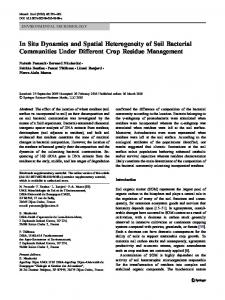
Key words Shifting agriculture; Farming systems analysis; Soil dynamics; Landscape fragmentation; Rain forest; Southern Cameroon. Introduction In the tropical rain forest zone of Southern Cameroon, the spatial pattern of the shifting agricultural land use system is a landscape mosaic system (Forman 1995), which is defined here as a spatial and temporal heterogeneity of aggregated elements of distinct boundaries, where various fallow types, various food crop fields, various perennial plantation types, undisturbed forest, and settlement areas are repeated in similar form over the landscape. This leads to a dynamic process acting in soil and on the spatial pattern of land use/Land cover (LULC) within the mosaic system. Beside the small-scale farmers’ agriculture, the sustainable use and management of the national forests has become a challenge at national as well as international levels (ITTO 1990). In such a context of multifunctional use of the space, better land management practices that can ensure efficient use of energy and nutrient capital from soil-vegetation complex, and minimize land use conflicts should be promoted. However, this can only be effective if based on thorough knowledge on integrative indicators of the current status of the agricultural production capacity of land and their changes over time. This is what motivated the research reported in this paper which main objective was to provide quantitative information, developed through modelling processes, on short and long-term effects of shifting agriculture on soil and the landscape dynamic in space. The research design and methods The study area is located between 2º47’ - 3º14’ N and 10º24’ - 10º51’ E. It belongs to the mid-altitude dense moist evergreen Biafran forest of Cameroon (Gartlan 1989). Two rainy seasons account for 1600-2000 mm of annual rainfall. Most soils are Ferralsols and Acrisols (FAO-ISRIC 2006). The area is sparsely populated. Selective industrial logging and extensive shifting agriculture are the most important land use activities. In four representative villages of the area, a synchronic approach for data collection was combined with diachronic monitoring of plots during the two-year cropping period and after five subsequent years. LULC treatments (10 in total) were chosen based on actual agricultural production cycles (Figure 1) described in Yemefack (2005, Chapter 2). Samples were taken with 3-4 replications in each village. In selected LULC patches, composite soil samples were collected, at three depths (0-10, 10-20, and 30-50 cm). Soil samples were analysed in the IRAD laboratory for pH, organic matter, available phosphorus, exchangeable bases, exchange acidity and particle size distribution, using procedures described in Van Reeuwijk (1993). Surface areas of 293 crop fields opened within three years by 35 households were measured. 33 plots were monitored from the first year of cropping to seven years. © 2010 19th World Congress of Soil Science, Soil Solutions for a Changing World 1 – 6 August 2010, Brisbane, Australia. Published on DVD.
138
Figure 1. Observed transitions between land uses. Adapted from Yemefack (2005, Chapter 2) Key:( ) Common transitions; ( ) Infrequent transitions; ( ) PF recovery after definite abandonment; (+) patches can split (fragmentation); (-) patches can merge with others of the same type (consolidation); (*) patches can merge with those of other types.
Investigating landscape spatial fragmentation, two questions guided our research: (i) Can Landsat-7 ETM+ imagery be used to map various LULC of the area? (ii) At which level of aggregation could this landscape structure be characterized in terms of composition and spatial configuration? In two sample sub-areas (Ebimimbang area on Acrisols and Mvie area on Ferralsols), the geographic coordinates of the centre of 158 LULC patches were recorded with a GPS six weeks before the image was taken on the 31 March 2003. Descriptive statistics, analysis of variance and means separations (Tukey’s method), principal component analysis, cluster analysis, discriminant analysis, and geostatistical analysis were applied to different datasets designed purposely for each specific objective. Detailed descriptions of these analyses are giving in Yemefack (2005). The analyses were carried out with R environment (Ihaka and Gentleman 1996). Spatial analysis and remote sensing processing were done using ILWIS (ITC ILWIS Unit 2001). Results and discussion
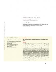
Dynamics of shifting agriculture The analysis of farmers’ field size distribution and the conceptual model of land use dynamic exposed the issue of rotational fallow systems, which tend to replace the ideal shifting cultivation in which short-term cropping alternates with secondary forest on a plot. This has shown (Figure 2) that 1/5 of food crop field plots were based on short rotational fallow cycles (RSFS), about 1/2 on long rotational fallow cycles (RLFS), 1/5 on very long fallow cycles (RVFS), and 1/10 on forest conversion (FCS). If the shorter fallow cycles are sustainable, this may require intensification: tighter integration into the market economy and some purchased inputs, with special attention to nutrient cycling and soil management. PF PP FCF FF
CL
BF CF
Key: …………………
Cycle CL-BF-CL (RSFS) CL-CF-BF-CL (RLFS) CL-CF-BF-FF-FCF-CL (RVFS) PF-FCF (FCS) PP cycle PF recovery
Area (%) Household (%) 19 32 52 52 17 11 12 5 3-25 (including elites’ plantations) unknown
Food crop production cycles
Figure 2. Cycle proportions of shifting agricultural land use management in southern Cameroon. Adapted and modified from Yemefack (2005, Chapter 2).
In this study, 35 households cleared 95 ha in three years, of which 88% of the area cleared for crop fields came from fallow lands and only 12% from primary forest (Figure 2). However, with the involvement of © 2010 19th World Congress of Soil Science, Soil Solutions for a Changing World 1 – 6 August 2010, Brisbane, Australia. Published on DVD.
139
elites in agricultural plantations, net deforestation is probably occurring, since their plantation plot sizes are far larger than those of small farmers. This brings the total proportion of PF in the cleared area to about 40% when including elite plantations.
Soil variability in the study area For a better understanding of complex relations between soil properties, environmental factors and land use systems, sources of soil variability were evaluated at four scales: region, village, plot and laboratory (Yemefack et al. 2005). This four-scale study was able to explain for several variables, an encouraging 80% (for less sensitive soil variables) to 95% (most sensitive ones) of the overall soil variation; with 5 to 70% by regional factors, 3 to 35% by local factors, 1 to 10% by within-plot factors, and less than 5% by laboratory errors. Land use practices significantly (p