ReGroup: Using Location Sharing to Support Distributed Information Gathering Tim Nugent School of Computing and Information Systems University of Tasmania, Australia
[email protected]
Christopher Lueg School of Computing and Information Systems University of Tasmania, Australia
[email protected] current location of group members along information about their immediate past routes.
ABSTRACT
Many shared group activities, such as determining the range of different foods offered at a market, require that group members know which parts of the market will be covered by which people. In this paper we report findings from evaluating ReGroup, a mobile distributed information system that enables group members to "see" the current and immediate past routes of other group members within a defined area. ReGroup collects and shares GPS location data on a number of participating mobile phones. Past routes are visualised as coloured lines on a map of the surrounding area. An initial evaluation of the system at a busy marketplace suggests that there is a great deal of potential usefulness in sharing previous locations amongst members of a group.
with
As a scenario for evaluating the ReGroup prototype, we used members of a group trying to determine the range of different items offered at a local market. While this is fun activity, the underlying mechanism is the same as in more sincere tasks, such as trying to retrieve a valuable item lost in bushland or trying to find a child that has wandered off at a beach. We proceed as follow; first, we discuss systems that have explored aspects of location awareness and location sharing as relevant to the design of ReGroup. Then we outline the evaluation of ReGroup during a local market event and discuss selected findings. The paper concludes with a discussion of the strengths and weaknesses of the current system and future research.
AUTHOR KEYWORDS
Location awareness, information sharing, collaboration, mobility, navigation, usefulness
Related Work
The design of ReGroup has benefited from a number of systems that have explored aspects of location awareness and location sharing, including ActiveMap, mExplore, CityFlocks and co-visiting systems.
ACM CLASSIFICATION KEYWORDS
H5.m. Information interfaces and presentation (e.g., HCI): Miscellaneous.
ActiveMap (McCarthy and Meidel 1999), was designed to facilitate impromptu meetings amongst employees and to allow people to have at-a-glance awareness of everyone in the workplace. ActiveMap displayed the location of every other person in the workplace as well as displaying how long it had been since they were last located by fading photographs overlaid onto a map of the workplace. Unlike ReGroup, ActiveMap was restricted to indoors and had limited support for showing where a person had been.
INTRODUCTION
Recent times have seen an explosion in mobile devices with the ability to share information amongst one another. Location aware technologies, such as GPS, are becoming more and more commonplace with many of the smart phones available on the market having the capability to determine where it is located and share this information. Knowing someone’s location is an important aspect of understanding his or her current situation. Barkhuus et al. (2008), for example, suggest that there is a strong link between a person’s location and his or her activity. To this end, a great deal of research has be conducted into making use of location-aware technology, studying the effect that knowing where a person is located, either in general terms or precisely, has on a person’s or group’s behaviour.
mExplore (Lueg et al. 2006), is a mobile information system aiming at supporting reflective exploration of an area. To this extent mExplore provides a representation of previous routes as paths on a map. mExplore also supported people in documenting their exploration experience by recording textual, audio and photographic annotations taken and then associate these with the location they were recorded at. The general idea is that the system allowed tourists to reflect upon what they have seen and done in an attempt to improve the experience of visiting and revisiting an area of interest. mExplore, only supports single users at once, whereas ReGroup allows groups to share experiences amongst each other at the same time.
In this paper we describe the design and evaluation of ReGroup, a mobile prototype for increasing social awareness and informal planning for groups. Unlike most other currently available systems, ReGroup features the OZCHI 2010, November 22-26, 2010, Brisbane, Australia. Copyright the author(s) and CHISIG Additional copies are available at the ACM Digital Library (http://portal.acm.org/dl.cfm) or ordered from the CHISIG secretary (
[email protected]) OZCHI 2010 Proceedings ISBN: 978-1-4503-0502-0
CityFlocks (Bilandzic et al. 2008), is another outdoor system that leverages indirect and direct social navigation to allow people to add location based information and
372
tags, which were then searchable by others using a mobile device. The intention being locals would add information into the system that visitors or new residents would be able to make use of at a later date. Making use of Google Maps in a web interface CityFlocks allowed people to add location based information and tags which were then searchable by others using a mobile device. This research makes use of the CityFlocks idea of informed users creating and sharing information for other people to use.
available for download as needed. The client prototypes downloaded other clients location and annotation information from the server at five-second intervals. The intention behind this is keeping the information displayed to the participants up to date without mobile download allowances.
The co-visiting system (Brown et al. 2003) is an unusual system in that it mixes indoor and outdoor information sharing. The idea is that people can co-visit a museum regardless of where they are located, with some users connected via the internet and others being in the museum. The overall goal is to increase the amount of social interaction amongst users. The different visitors were able to interact amongst one another as if they were physically located with one another. This idea of physically separate people interacting as if they were colocated is what this research makes use of from the covisiting system. Lee et al. (2008) developed another outdoor system that allows users to capture the in-situ experience a person is having as they roamed about a night market in Taiwan, and share this experience with whoever is nearby. The prototype enabled users to take photos of points of interest, which were then stored on their phones. Any other user coming within Bluetooth range would be able to view the photos stored on the phone and vise versa. Unlike the systems discussed so far ReGroup takes the approach of sharing current and past location information amongst members of a group. It allows users to see at a glance the previous location of every person with the goal of enhancing the participant’s ability to coordinate as a group without the need for specific planning beforehand. Increasing the amount of social interaction amongst the distributed group members was another goal.
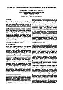
Figure 1: Screenshot of the prototype showing a number of different routes as coloured lines on a map
The design of the prototype was to keep inline with iPhone design guidelines as well as keeping the interface simple to make it as easy as possible for the participants to use it.
THE REGROUP PROTOTYPE
In order to evaluate the usefulness of ReGroup’s approach to route information sharing for informal coordination, we developed and evaluated two prototypes, each focussing on selected aspects of the approach.
As shown in figure 1 most of the iPhones display was taken up with a map of the area where the evaluation was conducted, in this case Salamanca Place. The map data was provided by Google Maps in satellite view mode. ReGroup visualises not only the participants own previous location as a thin line overlaid onto the map but also the previous location paths for all other members of the group, with each member having a different coloured line to differentiate between them.
Each ReGroup prototype was developed as two different components, in a client-server architecture with a server to hold and distribute all content being shared amongst the participants and a number of mobile clients to collect and display the groups information to its members. Both mobile client components run on a third generation Apple iPhone with the location of the participants being determined through the iPhones built in assisted GPS capabilities.
Along the top of the iPhone screen there was a textfield and button for the participants to create annotations. For the purposes of the evaluation the annotations were limited to textual information alone and were represented on the map as a pin. The pins are placed on the map at the location of the participant when they created the point of interest.
All of the data generated by the client prototypes, the location data and annotations, were sent back to the server for collation and redistribution to the clients at approximately five-second intervals through the 3G wireless facilities of the iPhone. The server collated all data sent to it by the different clients and made it
A second version of ReGroup was also created which only showed the participant’s own previous path and the
373
groups annotation; this was designed to be used in a comparison against the fully featured prototype. Evaluation of ReGroup at Salamanca Markets
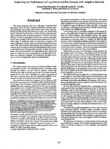
Due to the group and mobile aspects of this research a multi-dimensional approach to the evaluation of the system was chosen, combining different aspects of rapid ethnography and field studies to gather as much valid data as possible in the time available. Questionnaires were used to collect the participants views on the system and the prototypes did a great deal of data collection themselves for later analysis. The evaluation of ReGroup took place at the popular tourist attraction of the Salamanca Markets. Salamanca Markets are an open area marketplace held every Saturday from 8:30am to 3:00pm located at Salamanca Place in Hobart. Every market day attracts thousands of locals and visitors perusing and purchasing locally made and grown products. The layout of Salamanca Markets is mostly unchanging every market day and follows the shape of the road going through Salamanca place. The reason for choosing Salamanca Markets as the evaluation area is due to it being outdoors with a great deal of activity and a large number of potential points of interest. Being evaluated outside is also important for the purposes of getting reasonably accurate location results from the GPS on the iPhone.
Figure 2: Salamanca Markets DISCUSSION
Whilst it was not the intention of this research to create a consumer ready program, the usability of the prototype still has an impact upon the results and as such should be discussed. Due to a software bug annotations could not have any spaces, the participants got around this by posting comments in CamelCase style. The majority of the participants also had issue with cluttering on the screen from the previous paths. When two or more people walked close to one another their paths overlapped and the one path was drawn over the top of the other, making it hard for the participants to determine where each group member had been. Participants got around this limitation by leaving annotations such as “travellingTogether” and “peterAndFord,” so that the rest of the group were able to figure out where each group member was located. The manner in which the participants adapted the prototypes for their own purposes and to get around it’s limitations bears similarity to the mobile phones study by Carroll et al. (2003). Whilst this research is non-longitudinal the way the participants were adapting and adapting to the prototypes for their own purposes parallels with research showing early stages of the prototypes being appropriated by the participants.
The research data was collected from two small groups, one group of four and another group of three, with ethics approval being sought and gained before conducting any experimentation. All participants were familiar with the layout of the Salamanca Markets except one and every participant had used an iPhone before the evaluation began. All participants were recruited from a local university, were male, within the ages of 18 – 25 and the majority were computing students. Every participant was given an iPhone with the modified prototype software running on it, the variant showing only the participants own path, and told a scenario. The scenarios were designed to give the participants something to focus on whilst exploring the market. The participants success at completing a scenario was not intended to be a metric in evaluating the prototype. The scenarios followed along the lines of “It is your friend’s birthday soon and he needs a new bottle opener, as a group you decide to get him a hand-crafted wooden one from the markets.”
Even with the prototype limitations, the participants were positive about the system and the potential that they contained. Every participant found that seeing where the other group members had been was beneficial but for different reasons. Some participants found that displaying the previous locations of the group enabled them to better cover different areas of the market or had a noticeable impact upon the path taken by participants, with comments such as “I went to cover areas not visited by others”, “I followed a different path to the others, covering a different area”, “Yes, to determine where to find them and where to go next” and “[I used] informal planning to cover more area quicker.” These comments imply that the prototypes did encourage the participants to break up and explore separately from one another, which in many ways collides with what the participants said and did when they used the prototypes to inform the rest of the group that some members were moving together. Furthermore, the paths taken by the participants do not show any particular separation of the group members to cover more area, but do show different
It was intended that the participants finish a scenario whenever they felt that they were finished and the participants were not required to purchase anything as part of the evaluation. Once the participants completed the scenario they were given the fully featured prototype and a new scenario, this was to see how, if any, the participants behaviour changed once they had access to the groups previous location, not just their own.
374
people merging and diverging as they wander about the market place.
diverge as much as they might do in a larger market environment.
When the participants were asked which prototype they preferred, every participant enjoyed the fully featured prototype more with some participants stating; “In the second [fully-featured prototype], to find annotations I can follow other lines. In the first annotations would spring up in random locations”, “The second one, there was more information” and “Prototype 2, information was important to tracking others and making decisions, and P2 provided more.”
Future research includes exploring different ways of representing where group members have been (e.g. greying-in or fading of geographic areas) and ways to make suggestions to others as to which part of an area they should aim to cover. REFERENCES
Louise Barkhuus, Barry Brown, Marek Bell, Scott Sherwood, Malcolm Hall, and Matthew Chalmers. From awareness to repartee: sharing location within social groups. In CHI ’08: Proceeding of the twentysixth annual SIGCHI conference on Human factors in computing systems, pages 497–506, New York, NY, USA, 2008. ACM. ISBN 978-1-60558-011-1.
Most participants stated they would like to be able to toggle on and off certain group members paths so they’d see only what they wish to see, in particular most participants did not want to see their own paths, with the foremost reason being that they were fully aware where they had been and didn’t need the prototype to tell them. The only exception to this was one participant who had never been to Salamanca Place or the markets before. Even whilst using the modified prototype, showing only the participants own path and the groups annotations, most participants saw little use in displaying their own path, with the comments about the prototypes usefulness focussing on the annotations and what information could be gleamed from them.
Mark Bilandzic, Marcus Foth, and Alexander De Luca. Cityflocks: designing social navigation for urban mobile information systems. In DIS ’08: Proceedings of the 7th ACM conference on Designing interactive systems, pages 174–183, New York, NY, USA, 2008. ACM. ISBN 978-1-60558-002-9. Barry Brown, Ian MacColl, Matthew Chalmers, Areti Galani, Cliff Randell, and Anthony Steed. Lessons from the lighthouse: collaboration in a shared mixed reality system. In CHI ’03: Proceedings of the SIGCHI conference on Human factors in computing systems, pages 577– 584, New York, NY, USA, 2003. ACM. ISBN 1-58113-630-7.
The participants used the annotations in several different ways, with only a quarter of all annotations posted having any relation to the scenarios. The rest of the annotations usage was broken up into information about the participants usage of the device, such as “travellingTogether” or anything that caught the participants eye, such as “OMGMetalPredators” and “sausageking” with a majority of all annotations created falling into this second category. The humorous nature of the majority of the annotations is quite similar to how some people used the annotation capabilities in the MobiTip system (Rudström et al. 2004).
Jennie Carroll, Steve Howard, Jane Peck, and John Murphy. From adoption to use: the process of appropriating a mobile phone. Australasian Journal of Information Systems, 10(2):38–48, May 2003. Chao-Lung Lee, Yun-Maw Cheng, Ching-Long Yeh, LiChieh Chen, Wai Yu, and Kuan-Ta Chen. Surfing in the crowd: feasibility study of experience sharing in a taiwanese night market. In Proceedings of the 20th Australasian Conference on Computer-Human Interaction: Designing for Habitus and Habitat, pages 239–242, Cairns, Australia, 2008. ACM. ISBN 09803063-4-5.
CONCLUSIONS
This paper presented a study into a mobile group exploration and awareness system, allowing a group of people to share previous location information and textual annotations amongst one another, allowing the group to see at a glance where the rest of the group had been and what they had done. A trial of this prototype system at the Salamanca Markets in Tasmania suggests that there is a great deal of potential usefulness in sharing previous locations amongst a group. The participants of the research enjoyed using the prototype and found it helpful towards completing the scenarios. It came as a surprise though that the system was used primarily for group awareness and less so for coordination and planning as originally intended.
Christopher P. Lueg, Christoph Göth, and Nicola J. Bidwell. Learning from insects?: towards supporting reflective exploration of unfamiliar areas of interest. In CHINZ ’06: Proceedings of the 7th ACM SIGCHI New Zealand chapter’s international conference on Computer-human interaction, pages 91–97, New York, NY, USA, 2006. ACM. ISBN 1-59593-473-1. McCarthy, J. and Meidel, E.: 1999, Active map: A visualization tool for location awareness to support informal interactions, Handheld and Ubiquitous Computing, Springer Berlin, pp. 158– 170. Rudström, Å., Svensson, M., Cöster, R. and Höök, K.: 2004, Mobitip: Using bluetooth as a mediator of social context. demonstration at UbiComp 2004, UbiComp 2004 Adjunct Proceedings
We are working on evaluating the system in larger and less structured environments than Salamanca Markets as the specific geographic layout of Salamanca markets, following the road in Salamanca Place, may have encouraged the participants to stick to the road and not
375