about 150 localities in 76 hectads in 29 vice-counties, mainly across central Ireland, and is ..... Co. Limerick (H8) and miscellaneous plant records in 2000. Irish Naturalists' Journal ... LIST OF LOCALITIES OF SORBUS HIBERNICA .... wood near Pilltown House, N. D. Simpson, S. M. Walters & D. A. Webb, 11 August 1958.
Watsonia 25: 369–380 (2005) DISTRIBUTION OF THE IRISH WHITEBEAM, SORBUS HIBERNICA
369
Distribution of the Irish Whitebeam, Sorbus hibernica E. F. Warb. (Rosaceae) T. C. G. RICH Department of Biodiversity and Systematic Biology, National Museums & Galleries of Wales, Cardiff CF10 3NP
A. J. LOCKTON BSBI Threatened Plants Database Project, 66 North Street, Shrewsbury, Shropshire SY1 2JL
and J. PARNELL Department of Botany, Trinity College, Dublin 2, Republic of Ireland
ABSTRACT
The distribution of the Irish endemic Sorbus hibernica E. F. Warb., Irish Whitebeam, is reviewed. Some 230 records were compiled from herbaria, the literature, correspondence and field work. It has been recorded in about 150 localities in 76 hectads in 29 vice-counties, mainly across central Ireland, and is rarely planted. Fewer than half of these records are in common with the S. hibernica map in the New Atlas of the British and Irish flora, which has a large degree of uncertainty associated with it. Limited data on population sizes suggest that most populations are very small (half of the sites have only one tree), and are too fragmentary to allow conclusions to be drawn about long-term population trends. It grows in a range of habitats occurring on acid and calcareous soils, in natural and man-made habitats (especially linear boundary features), in open and semiopen conditions, and with a broad range of other woody species. KEYWORDS: Conservation, ecology, endemic, Ireland, Sorbus aria. INTRODUCTION
Sorbus hibernica E. F. Warb., Irish Whitebeam, is one of the relatively few vascular plants endemic to Ireland. Its history dates from a botanical excursion to Galway by the two great botanists R. L. Praeger and H. W. Pugsley in May 1933. Praeger and Pugsley found a tree at Garryland, near Gort, which Pugsley referred to S. porrigens Hedl., a species he knew from Britain (Pugsley 1934; British plants are now referred to S. porrigentiformis E. F. Warb.). Subsequent investigation by Praeger indicated that this taxon was the most widespread of the S. aria (L.) Crantz group in Ireland, S. aria sensu stricto being uncommon and probably introduced, and S. rupicola (Syme) Hedl. being rare and scattered in the north and west (Praeger 1934). Praeger also collected further material which was sent to A. J. Wilmott at the British Museum (Natural History) in London, who at that time was working on a revision of British Sorbus. Wilmott recognised that it differed from other known Sorbus taxa and coined the epithet ‘hibernica’, but left it to Warburg to formally describe (Warburg 1952, formalised in Warburg 1957). Surprisingly, for an endemic tree, S. hibernica has been relatively little studied since, the only study being that of Parnell & Needham (1998) who investigated its morphological variation and its distinction from S. aria and other Irish Sorbus species. They showed that S. hibernica was as morphologically variable in Ireland as S. aria, and noted that further work was needed to confirm its apomictic nature and also to look more closely at its relationship with other taxa.
370
T. C. G. RICH, A. J. LOCKTON & J. PARNELL
Praeger (1934) listed the records of S. hibernica he had confirmed from nine vice-counties, and listed another four more doubtful ones. The first distribution map of S. hibernica was given in Perring (1968), which showed that it was relatively widespread across central Ireland, with outlying localities in v.c. H12 Wexford and v.c. H38 Co. Down, in 44 hectads (10 km × 10 km squares). The most recent distribution map in the New Atlas of the British and Irish flora (Preston et al. 2002) showed records for 63 hectads where it was considered native and three hectads where it had been planted, but the distribution pattern was somewhat different from that of Perring (1968) (a direct comparison is difficult partly due to the change to the Irish grid). Furthermore, some wellknown records such as those from v.c. H21 Wicklow (Brunker 1950) and v.c. H16 West Galway (Webb & Scannell 1983) were not included in the New Atlas map, and there were some records from areas in which it had not been previously reported and from where no vouchers had been seen. The New Atlas map of S. aria similarly is incomplete lacking a significant number of Irish records, especially from the west (D. L. Kelly, pers. comm. 2004). These problems led us to review the distribution of S. hibernica, and in this paper we summarise its distribution with an updated distribution map and ecological notes. In an attempt to avoid further confusion, we have presented the records in full so that they can be used in future studies. METHODS
Locality and habitat information in the literature and on herbarium sheets at BEL, BIRM, BM, BRISTM, CGE, DBN, LIV, MANCH, NMW, OXF, RNG and TCD were compiled with some additional information from the Biological Records Centre, Monks Wood, field surveys and correspondence with the BSBI vice-county recorders (the provisional data were circulated in May 2002). The herbarium material cited has all been reviewed by T. Rich, confirming many previous determinations made by workers such as P. J. M. Nethercott, R. L. Praeger, H. W. Pugsley, M. J. P. Scannell, P. D. Sell, E. F. Warburg and D. A. Webb, with occasional corrections. Literature records were only accepted where it was clear that the authors knew both S. hibernica and S. aria, but even then some records were corrected. Data were compiled into the BSBI Threatened Plants Database, and are available on request to A. Lockton. Grid references were compiled from the original collections and cross-checked (one ‘grid reference’ turned out to be a telephone number!), or for the older records were allocated to the most likely hectad using maps and gazetteers. For a more detailed map, best-guess 1-km square grid references were allocated to look at the clustering of sites. For comparison against the map in the New Atlas of the British and Irish flora (Preston et al. 2002), the S. hibernica data used to create the map were obtained from the Biological Records Centre, Monks Wood. These data had largely been supplied to the New Atlas project by the Office of Public Works from an unpublished and unchecked compilation of rare plant data prepared for a ‘Scarce Irish Plants’ project in the 1980s, and were largely summary hectad records for 1950+, 1970+ or 1987+, with very few details; we have not seen the original work for this project. They were cross-checked against the data in Appendix 1 to see how many records might equate, but the paucity of detail made the comparison somewhat uncertain. The New Atlas data have not been integrated into our data. Data associated with the records (Appendix 1) were used to compile information on the population sizes and habitats. Woody species noted growing within a few metres of S. hibernica were also noted in eight sites during a field trip to collect DNA samples from scattered recent localities between v.c. H12 Wexford and v.c. H16 West Galway (Houston 2003), but no formal vegetation sampling was carried out. At the same time, soil samples were collected from the rooting zone around the base of the tree and air-dried. Later in the laboratory, they were mixed into a 50:50 slurry with distilled water and the pH measured, after at least 10 minutes equilibration, with a pHep2 Hanna pocket-sized pH meter.
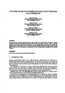
DISTRIBUTION OF THE IRISH WHITEBEAM, SORBUS HIBERNICA
FIGURE 1. Distribution of Sorbus hibernica in Ireland in hectads.
all dates. × = error.
371
planted
RESULTS
The c. 230 S. hibernica records traced are listed in Appendix 1, and indicate that there are probably over 150 localities in 76 hectads in 29 vice-counties, and two, possibly three, planted sites (most planted trees are S. aria; Praeger 1937). The earliest specimen traced was collected by H. C. L. Evans in 1885 at Knockdrin (DBN). The updated distribution map (Fig. 1) shows that S. hibernica is scattered mainly across the centre of Ireland, often in small clusters of sites, with outlying localities in the south and in the north. The 1-km square distribution map shows this clustering more clearly (Fig. 2). No doubt there are a significant number of additional unrecorded trees and populations. A comparison between Figure 1 and the New Atlas map (Preston et al. 2002) shows just 33 dots in common; 44 of the dots on Figure 1 are not on the New Atlas map, and 32 dots only occur on the New Atlas map. These 32 dots unique to the New Atlas map include records for vice-counties H7 South Tipperary, H27 West Mayo, H33 Fermanagh, H34 East Donegal and H36 Tyrone for which we have seen no material. The New Atlas map records may be correct, but there is a large degree of uncertainty about them; we would welcome further details preferably supported by vouchers. No consistent information is available on the population sizes or dynamics of S. hibernica, but there are fifty localities for which population data are available. These can be summarised as follows, taking the maximum counted for each site and excluding ‘occasional’, ‘scarce’, etc.: one single tree, 26 localities; two trees, eight localities; three trees, five localities; four trees, one locality; five trees, two localities; six trees, one locality; eight trees, one locality; ten or more trees, five localities; 100 or more trees, one locality. Thus half of the populations have only one tree. It is
372
T. C. G. RICH, A. J. LOCKTON & J. PARNELL
FIGURE 2. Distribution of Sorbus hibernica at 1-km square level in Ireland (symbols plotted at 2 km size for visibility). Planted sites are excluded
possible that the sample data are biased to small populations as they are ad hoc – it is simple to count and note one or two trees, but takes more time and searching to get better population estimates. However, taking these data at face value the average population size can be calculated as 6 8 ± 2 7 s.e. trees per population, with a median of 1 which might be considered more representative. Possible long term population trends across Ireland were investigated from the number of records for each decade, which can be summarised from the 1880s as follows: 1880–1889, 2 records; 1890–1899, 15 records; 1900–1909, 4 records; 1910–1919, 1 record; 1920–1929, 6 records; 1930–1939, 47 records; 1940–1949, 2 records; 1950–1959, 17 records; 1960–1969, 11 records; 1970–1979, 29 records; 1980–1989, 30 records; 1990–1999, 27 records; 2000+, 33 records. The large fluctuations between decades are due primarily to variations in the recording rather than in S. hibernica (e.g. there are disproportionate numbers of records for both the 1890s and 1930s when Praeger was investigating it), and other than noting that there are many recent records indicating it is currently widespread, no conclusions can be drawn about longer term trends. Records for some localities such as Roundstone Graveyard (1936–2003) show it can be persistent for long periods at some sites. The habitats in which it has been recorded are listed in Table 1. The commonest habitats recorded are hedges, woods and roadsides (the latter could include hedges and hedgebanks). The woods are often noted as rocky or open, and S. hibernica is often recorded on the edge of woods and only rarely occurs in deep shade. Lakeshores, river and canal banks make up 10% of the
DISTRIBUTION OF THE IRISH WHITEBEAM, SORBUS HIBERNICA
373
TABLE 1. HABITATS OF SORBUS HIBERNICA Habitat Hedge Roadside Wood Lake shore River/canal Rocks Railway Limestone pavement Hedgebank
Number of localities (%)
Habitat
Number of localities (%)
25 (22%) 20 (18%) 20 (18%) 7 (6%) 6 (5%) 5 (4%) 5 (4%) 4 (4%) 4 (4%)
Hills, hill slopes Cliff Quarry Islands Esker Walls Churchyard
4 (4%) 3 (3%) 3 (3%) 3 (3%) 2 (2%) 2 (2%) 1 (1%)
Not stated
44
TABLE 2. DETAILS OF SOIL COLLECTED FROM AROUND BASES OF SORBUS HIBERNICA TREES Locality Kilcullen Upper (v.c. H6) Boolabrien Upper (v.c. H6) Lough Derg, Annagh (v.c. H10) Preisthaggard (v.c. H12) Roundstone (v.c. H16) Clifden (v.c. H16) Killeigh (v.c. H18) Kilbeggan (v.c. H23)
Soil pH 35 33 70 37 62 56 69 55
Soil type blackish organic soil dark brown loam dark brown mineral loam fine brown loam blackish organic soil dark brown loam dark brown mineral loam black organic soil
recorded habitats, but in these situations it occurs in the banks and rocks associated with them rather than in the aquatic or semi-aquatic zones. Sorbus hibernica is occasionally recorded from cliffs, rocks and limestone pavements. It also occurs by railways and in quarries, and at one site occurs in a graveyard and at another on a ruined building. There is only limited information on its altitudinal range, occurring from just above sea level (Clifden) to semi-upland situations (316 m, Raven Rock is the highest altitude for which we have specific data). It occurs on quite a wide range of soil types (Table 2), the soils either being derived directly from the underlying geology, or from the overlying drift. It also occurs on gravelly eskers, and in the Irish midlands on boulder clay and onto at least shallow peat at the margins of bogs. The soils are generally likely to be well-drained, but it has been recorded from swampy woodlands. The soils range from being strongly acidic (pH 3 3) to calcareous (pH 7 0). Houston (2003) recorded 21 woody species and climbers associated with S. hibernica from eight sites in 2003. The most frequently recorded species were Rubus fruticosus (6 sites), Hedera helix (5 sites), and Crataegus monogyna, Ilex aquifolium and Salix cinerea (3 sites). DISCUSSION
The records of S. hibernica show it is scattered across central Ireland, often in small clusters, and it is rarer in the north and south. Nowhere is it common, and in general it is rare and uncommon. It appears generally tolerant of a range of habitat conditions, occurring on acid and calcareous soils, in natural and man-made habitats (especially linear boundary features), in open and semi-open conditions (rarely more closed woodland), and growing with a broad range of other woody species. This contrasts markedly with the behaviour of the more widespread apomictic Sorbus species in Britain such as S. anglica Hedl., S. porrigentiformis and S. rupicola which tend to be restricted to cliffs or open rocky woods on calcareous soils in the more natural areas of the landscape. It is more similar to S. devoniensis and S. aria which also occur in hedges and woods on a range of soils in the more intensively used areas of southern England. In Ireland, the introduced S. aria also behaves somewhat like S. hibernica in that it occurs in similar habitats, but it may be more invasive (personal observations).
374
T. C. G. RICH, A. J. LOCKTON & J. PARNELL
The combination of the contrasting clustered/scattered distribution pattern of S. hibernica, its widespread occurrence in man-made boundary features or other linear habitats, and small often isolated populations, suggests it behaves as a metapopulation with both colonisation and loss of sub-populations within an area. Some records note regeneration and the presence of saplings, and the records for quarries and railways show that it can colonise new habitats. There is little information on its reproductive biology to investigate the functioning of the metapopulation further. The only chromosome count traced is 2n = (50–)51 from seed from Rathdrum, Wicklow (Q. O. N. Kay, pers. comm. 2004), and like most polyploid species of Sorbus it is assumed to be apomictic and pseudogamous though this has not been tested. Plants in Botanic Gardens set fertile fruit (e.g. at Trinity College Botanic Garden, S. Waldren pers. comm. 2004, and at Cambridge Botanic Garden, pers. obs. T. Rich). The fruits are probably dispersed mainly by birds. Whilst these processes are on-going there seem to be no immediate concerns for its conservation, but as an endemic it should merit inclusion in the Irish Red Data Book (Curtis & McGough 1988) at its next revision. ACKNOWLEDGMENTS
We would like to thank the Keepers of the herbaria for access to collections and libraries, and Catriona Brady, Declan Doogue, Trevor Evans, John Faulkner, Ro FitzGerald, Ian Green, Paul Green, Paul Hackney, John Harron, Mat Hodd, Libby Houston, Matthew Jebb, Tony O’Mahony, Sylvia Reynolds and Maura Scannell for information and help with records, and Brian Rushton for helpful comments on the manuscript. REFERENCES
BRUNKER, J. P. (1950). Flora of the County of Wicklow. Dundalgan Press (W. Tempest) Ltd, Dundalk. CURTIS, T. G. F. & MCGOUGH, H. N. (1988). The Irish Red Data Book. Vol. 1. Vascular Plants, Stationery Office, Dublin. DAWSON, N. (1983). Plant records from Co. Armagh. Irish Naturalists’ Journal 21: 181–184. DOOGUE, D., NASH, D., PARNELL, J., REYNOLDS, S. & WYSE JACKSON, P. (1998). Flora of County Dublin. The Dublin Naturalists’ Field Club, Dublin. FERGUSON, I. K. & FERGUSON, L. F. (1981). Further records for Co. Waterford (v.c. H6). Irish Naturalists’ Journal 20: 348–350. GREEN, P. (2001). Recording in Co. Waterford (v.c. H6) in 2000. Irish Botanical News 11: 37–41. GREEN, P. (2003). Recording in 2002 for a Flora of Co. Waterford (v.c. H6). Irish Botanical News 13: 41–42. HOUSTON, L. (2003). Irish Sorbus collecting trip. Unpublished report, National Museums & Galleries of Wales, Cardiff. MARSHALL, E. S. & SHOOLBRED, W. A. (1896). Irish plants observed in July 1895. Journal of Botany 34: 250–258. MCKEE, N. (2000). Walks in Wildwoods. Irish Botanical News 10: 25–29. PARNELL, J. A. N. & NEEDHAM, M. (1998). Morphometric variation in Irish Sorbus L. (Rosaceae). Watsonia 22: 153–161. PERRING, F. H., ed. (1968). Critical Supplement to the Atlas of the British flora. Botanical Society of the British Isles, London. PRAEGER, R. L. (1901). Irish Topographical Botany. Proceedings of the Royal Irish Academy, 3rd Series 7: 1– clxxxvii & 1–410. PRAEGER, R. L. (1934). The Sorbus aria group in Ireland. Irish Naturalists’ Journal 5: 50–52. PRAEGER, R. L. (1937). The white-beams of Garron Point. Irish Naturalists’ Journal 6: 290–293. PRESTON, C. D., PEARMAN, D. A. & DINES, T. D. (2002). New Atlas of the British and Irish flora. Oxford University Press, Oxford. PUGSLEY, H. W. (1934). Sorbus porrigens Hedlund, in Ireland. Journal of Botany 72: 58. REILLY, P. A. (2001). The flora of County Cavan. Occasional paper No. 13. National Botanic Garden, Glasnevin. REYNOLDS, S. (2003). Co. Limerick (H8) and miscellaneous plant records in 2000. Irish Naturalists’ Journal 27: 208–209. SCANNELL, M. J. P. & SYNNOTT, D. M. (1990). Records for the census catalogue of the Flora of Ireland in the herbarium National Botanic Gardens, Glasnevin. Occasional paper no. 5. National Botanic Garden, Glasnevin.
DISTRIBUTION OF THE IRISH WHITEBEAM, SORBUS HIBERNICA
375
WARBURG, E. F. (1952). Sorbus L., in CLAPHAM, A. R., TUTIN, T. G. & WARBURG, E .F. Flora of the British Isles, pp. 539–556. Cambridge University Press, Cambridge. WARBURG, E. F. (1957). Some new names in the British flora. Watsonia 4: 44–45. WEBB, D. A. & SCANNELL, M. J. P. (1983). Flora of Connemara and the Burren. Royal Dublin Society/ Cambridge University Press, Dublin and Cambridge.
(Accepted February 2005)
APPENDIX 1 LIST OF LOCALITIES OF SORBUS HIBERNICA Localities for which there was no original grid reference are usually cited for a hectad only. Usually only one grid reference is given per locality. Erroneous and unconfirmed records are given in square brackets. [H2 NORTH KERRY
Records for Long Range and Ross Island, Killarney area refer to S. rupicola and/or S. aria.] H4 MID CORK
Belgooly, roadside tree, occasional in the area, W65, M. J. P. Scannell, 22 May 1987 (DBN). Castlenalact, roadside hedge south of, W45, M. J. P. Scannell & J. White, 24 May 1976 (DBN). H5 EAST CORK
Monavarnoge, 1 tree, W98, M. J. P. Scannell, 5 September 1989 (DBN). H6 CO. WATERFORD
Boolabrien Upper, 8 trees, P. R. Green, 28 May 2003 (NMW). Nine trees along 40 m of hedgebank on the east side of the road, S189157, L. Houston, 18 September 2003 (NMW). Cheekpoint, rocky cliff by bank of River Suir, S690135 (originally cited incorrectly as S675135), I. K. & L. F. Ferguson, 10 August 1975 (DBN, Ferguson & Ferguson 1981). The trees were later cleared from this cliff, and it has not been seen here again (P. R. Green, pers. comm. 2002). Coolbunnia, 1 tree in hedge, S682125, P. R. Green, 10 June 2003 (NMW). Crinnaughtaun West, 1 tree in hedgerow on west side of road, X125994, P. R. Green, 30 September 2003 (P. Green, pers. comm. 2004). Curragh, a large tree on a field bank at R992053, and eleven small trees scattered over moorland amongst Calluna vulgaris and Ulex gallii at R991051, I. P. Green, 7 June 2000 (Green 2003). Kilcullen Upper, 2 trees, S685113, P. R. Green & J. Wallace, 9 June 2003, (NMW). On slope above the River Suir, 2 trees, S684113, L. Houston, 17 September 2003 (NMW). Killoter, 41+ trees, X1491, P. R. Green, 3 June 2003 (NMW). Raven’s Rock, 1 tree in a crevice on top, S258210, P. R. Green, 27 April 2000 (Green 2001). H8 CO. LIMERICK
Ballyadam townland, SW of Cappagh, R3744, S. C. P. Reynolds, 3 August 2000 (DBN, Reynolds 2003). Cappagh, in a roadside hedge and by the railway SSW of, R3844, S. C. P. Reynolds, 3 August 2002 (DBN, Reynolds 2003) and 21 July 2003 (NMW). Pallas Green, R74, W. E. Bentley, 1897 (DBN, Reynolds 2003). Patrickswell, by the railway, R34, R. N. Goodwillie, 1990 (Reynolds 2003, unconfirmed but accepted). H9 CO. CLARE
Corkscrew Hill, 1 stunted shrub growing out of a deep gorge in limestone pavement, M20, C. A. Stace, August 1966 (LTR). “G. M.”, 29 May 1969 (MANCH).
376
T. C. G. RICH, A. J. LOCKTON & J. PARNELL
Ennis, near, R37, R. A. Phillips, 11 June 1933 (DBN). Ballyallia Lough, landscaped area near lake, possibly planted, C. M. Brady, 22 June 2002 (NMW). Newtown Castle, hill slope above, M20, E. C. Nelson, 5 September 1990 and 16 August 1992 (DBN). H10 NORTH TIPPERARY
Annagh, woodland and roadside by Lough Derg, 120+ trees, R8290, L. Houston, 18 September 2003 (NMW). Ballinderry, 3 trees in woodland edge on east side of private drive, R837978, L. Houston, 18 September 2003 (Houston 2003). Coolbaun, limestone quarry, west of Borris Okane, R89, M. J. P. Scannell, 25 May 1968 and 23 July 1968 (DBN). Twenty trees, R831923 (Parnell & Needham 1998). Dromineer, Hazel Point 3 km south of, 5–6 trees, R88, D. A. Doogue, 27 August 1990 (confirmed M. C. F. Proctor, no voucher retained). Monaincha Bog, 4 km SE of Roscrea, S18, M. J. P. Scannell, 20 July 1968 (DBN). Slevoir Bay, Loch Derg, 1 tree on limestone pavement, M8803, R. J. Pankhurst, 4 August 1975 (BM, DBN, TCD). Templemore, S17, R. A. Phillips, 1 December 1933 (DBN, Praeger 1934). Terryglass, near Portumna, M80, R. L. Praeger, 18 July 1934 (DBN). Lough Derg, limestone lake shore, Bellvue House, R. FitzGerald, 24 July 1991 (DBN). H11 KILKENNY
Rosbercon, S62, R. A. Phillips, August 1919 (DBN). Thomastown, natural wood, S54, R. L. Praeger, 30 July 1898 (DBN, Praeger 1934). H12 CO. WEXFORD
Bargy Commons, 1 tree in roadside hedge, S91, D. A. Webb, 2 August 1965 (TCD). Bunclody, roadside hedgerow on main road between Bunclody and Carnew, S959601, S. M. Walters, June/July 1978 (CGE). 1 tree overhanging river, S910577, S. M. Walters, 30 June 1978 (CGE). Butlerstown Castle, 2 trees in a hedgebank east of, T0308, R. FitzGerald, 23 July 1992 (DBN). Coolmela, Clonegall, hedgebank, S9560, R. FitzGerald, 15 September 1991 (DBN). Dunbrody Abbey, 1 tree on bank near railway, S7115, R. FitzGerald, 24 August 1992 (DBN). Ferrycarig, T02, A. W. Stelfox, 26 July 1929 (DBN). Killaven, 1 tree in hedge by lane, S6920, R. FitzGerald, 22 September 1991 (DBN). The Wood, S6920, R. Warner, 20 September 1995 (DBN). Pilltown, hedge, S71, N. D. Simpson & S. M. Walters, 12 June 1952 (BM). 2 trees in planted alder wood near Pilltown House, N. D. Simpson, S. M. Walters & D. A. Webb, 11 August 1958 (BM, CGE, TCD). Priesthaggard, S61, D. C. McClintock, 20 May 1953 (RNG; material young, but acceptable). 2 trees on edge of wood by roadside, S698180, T. C. G. Rich, 29 September 1998 (NMW). 3 trees, L. Houston, 17 September 2003 (NMW). Shelmalier Commons, 1 tree in blackthorn/whitethorn hedge, S81, T. Casey, 9 September 1984 (DBN). H13 CO. CARLOW
Gibbet Hill, old roadside west of, S95, E. Booth, 28 September 1978 (CGE). H14 LAOIS
Maryborough Queens, esker ridge north of, R. L. Praeger, 3 August 1896 (DBN, Praeger 1934). Esker near, R. A. Phillips, 7 October 1926 (DBN). Old hedge near esker gravel pit along a side road north of, N4704, R. FitzGerald, 10 September 1991 (DBN). Portarlington, canal 3 km south-west of, N5110, R. L. Praeger, 1 June 1934 (DBN). Stradbally, roadside 3 km west of, S535976, S. M. Walters, 1 July 1978 (CGE). H15 SOUTH-EAST GALWAY
“South Galway”, in scrub on limestone pavement, W. A. Watts, 1 May 1953 (TCD). Ballindereen, M31, E. C. Nelson, 17 August 1992 (DBN).
DISTRIBUTION OF THE IRISH WHITEBEAM, SORBUS HIBERNICA
377
Castle Lambert, roadside fence, M42, R. L. Praeger, May 1936 (BM, DBN). Castle Taylor, M40, R. L. Praeger, 3 October 1936 (BM, DBN). Coole, limestone crag, M40, R. A. Phillips, 15 June 1933 (DBN). Occasional around Coole (Webb & Scannell 1983). Galway, Merlin Park, outside wall, M32, Miss Gough, July 1935 (DBN, Webb & Scannell 1983). Galway, presumably planted in an enclosure near a house, in park 3 km east of Galway, M32, S. M. Walters & P. D. Sell, 21 August 1952 (CGE). Garryland, Gort, limestone rocks, Cragland Wood, M40, R. L. Praeger & H. W. Pugsley, 16 May 1933 (BM, DBN, Praeger 1934). Garryland Wood, T. G. Tutin, 20 August 1952 (LTR). Limestone pavement, Garryland Turlough, V. Gordon, 11 July 1967 (LIV). Garryland, woodland, M. J. P. Scannell, 11 July 1967 (DBN). Ten trees on limestone pavement, Anon., 28 May 1981 (BSBI Threatened Plants Database 1999–2003). Gort, west of, M40, T. G. Tutin, 20 August 1952 (TCD). Occasional around Gort (Webb & Scannell 1983). Kilmacduagh, near, M40, T. G. Tutin, 21 August 1952 (CGE, Webb & Scannell 1983). Lough Derg at Portumna, limestone shore about 4 5 km south of, M80, N. D. Simpson, 22 June 1952 (BM). West shore of Loch Derg, a little below Portumna Golf Course, limestone, J. N. Mills, 30 August 1953 (MANCH (one sheet mixed with S. rupicola), OXF). Open limestone woods north of Loch Derg, R. P. Libbey, 8 August 1974 (LTR). Oranmore, Rocklands near, M32, R. L. Praeger, 4 October 1936 (BM, DBN). Oranmore, south of (Webb & Scannell 1983). H16 WEST GALWAY
Ballynahinch, L74, R. L. Praeger, 27 September 1936 (BM). E. F. Warburg, 26 (holotype) and 27 September 1938 (BM, Warburg 1957, Webb & Scannell 1983). Clifden, beach road, T. G. Evans, 10 June 1990 (NMW). 1 tree on the sea wall about 1 5 km along the beach road, L643503, L. Houston, 21 September 2003 (NMW). Errislannan Point, roadside thicket, L6249, M. J. P. Scannell, 17 September 1975 and 23 October 1978 (DBN). 1 bushy tree in Salix thicket at tip of Errislannan Peninsula, L64, D. A. Webb, 5 September 1979 (TCD). D. A. Webb & M. J. P. Scannell, 1983 (TCD, Webb & Scannell 1983). [Oughterard; herbarium vouchers and field searches indicate that records from around Oughterard, M14, reported by Webb & Scannell (1983) and others, are all S. aria; Houston 2003.] Roundstone Church, in rough corner, R. L. Praeger, September 1936 (BM, DBN). 1 tree in graveyard (Webb & Scannell 1983). 1 tree, L722401, L. Houston, 21 September 2003 (NMW). H17 NORTH-EAST GALWAY
Clonber, near (see also East Mayo), scarce, M05, E. S. Marshall & W. A. Shoolbred, 15 July 1895 (BM, DBN, Marshall & Shoolbred 1896 (as S. aria), Webb & Scannell 1983). Grange, near road north of, M42, E. F. Warburg, 25 September 1936 (BM). Headford, 2 old trees in open woodland c. 5 km SE of, M24, S. M. Walters, T. G. Tutin & D. A. Webb, 21 August 1952 (CGE, LTR, OXF, TCD). Lough Bofin, 1 tree near the road south-east of, M04 (Webb & Scannell 1983). H18 OFFALY
Clonad Wood, near Geashill, R. L. Praeger (Praeger 1934). Edge of east end of Clonad Wood, N338186, S. M. Walters, 1 July 1978 (CGE). Hedge, N3119, R. FitzGerald, 18 June 1981 (DBN). Seagull Bog, 2 trees in hedge at southern edge, Killeigh, N358195, T. C. G. Rich, June 1994 (no voucher). 1 tree, T. C. G. Rich, M. F. Foley & S. Buczaki, 29 September 1999 (NMW). 1 tree, L. Houston, 19 September 2003 (NMW). Tullamore, hedgerow south of, N32, R. L. Praeger, 25 May 1895 (DBN, Praeger 1934). H19 CO. KILDARE
Milltown, hedgerow, N71, R. L. Praeger, August 1932 (DBN).
378
T. C. G. RICH, A. J. LOCKTON & J. PARNELL
H20 CO. WICKLOW
Aughrim, roadside near, T17, J. P. Brunker, 1928 (Brunker 1950). Shelter belt woodland on north side of Rathdrum road 2 km from Aughrim, T146795, S. M. Walters, 25 June 1978 (CGE, TCD), and D. A. Webb, July 1978 (CGE, TCD). Avondale, looking wild, T18, R. L. Praeger, 1899 (Praeger 1901). J. P. Brunker, 1933 (Brunker 1950). Ballinacor, roadside between Avoca and, T18, J. P. Brunker, 1932 (Brunker 1950). Ballinclea, roadside near, S99, A. W. Stelfox, 1940 (Brunker 1950). Ballyknockan, in hedges by the field path from Ballinatone to Rathdrum, O00, J. P. Brunker, 1934 (Brunker 1950). Bellevue, roadside north of, O21, J. P. Brunker, 1945 (Brunker 1950). Blainroe, 1 tree in hedgerow south-west of, T312903, C. M. Brady, 15 June 2002 (NMW). Bullingate, frequent, lane near the main Bunclody-Bullingate road with S. intermedia, E. Booth & M. McC. Webster, 30 August 1960 (OXF). Carriggower, roadside, ½ km north of, O2306, J. P. Brunker, 1925 (Brunker 1950). Delgany, large tree, Old Bellvue Estate, O21, A. W. Stelfox, 15 August 1934 (DBN). Dunlavin, railway banks 1 5 km south of, N80, R. L. Praeger, 1934 (DBN, Brunker 1950). Fortfaulkner, roadside near, T170802, S. M. Walters, 25 June 1978 (CGE). Greenan, by the river in Ballinacor Desmesne, T18, J. P. Brunker, 1937 (Brunker 1950). Killoughter, small roadside tree, T39, M. J. P. Scannell, 26 May 1979 (DBN). Killybeg, by a lane on the east flank of Keadeen Mountain, S98, J. P. Brunker, 1930 (Brunker 1950). Kilmullin Glen, O20, A. W. Stelfox, 1927 (Brunker 1950). Kilpipe, T17, J. P. Brunker, 1933 (Brunker 1950). Rathdrum, riverbanks at, T18, H. C. Hart, undated (Brunker 1950). On the embankment of the viaduct, J. P. Brunker, 1938 (Brunker 1950). Roadside hedge, NW side of road half way from Rathdrum to Greenane, T168878, S. M. Walters, 25 June 1978 (CGE). Hedge on north side of road half way between Greenane and Rathdrum, T18, D. A. Webb, 22 July and 11 September 1978 (TCD). 1 tree on the roadside 1 km south-west of Rathdrum, T1887, D. L. Kelly, 2 September 1990. Roddenagh Bridge, between Annacurragh and, T17, J. P. Brunker, 1930 (Brunker 1950). Spring Farm, Kilpedder, O20, J. P. Brunker, 1934 (Brunker 1950). The Devil’s Glen, south side, O20, A. W. Stelfox, 1934 (DBN, Praeger 1934, Brunker 1950). J. P. Brunker (Brunker 1950). The Scalp, by the road at the south end, O21, J. P. Brunker, 12 July 1932 and 1934 (DBN, Brunker 1950). Tinnakilly, T17, J. P. Brunker, 1934 (Brunker 1950). View Crag, among the crags on the west side of the Glen of the Downs, O21, Dublin Naturalists Field Club, 1901 (Brunker 1950). J. P. Brunker, 1924 (Brunker 1950). [Glencree, O11, J. Ball, cited by Brunker (1950) probably refers to a specimen of S. aria s.s. collected in June 1837 (BEL).] H21 CO. DUBLIN
Anna Liffey Mills, in garden by River Liffey, O03, R. L. Praeger, September 1937 (DBN). Ballybetagh, a little south of Kiltiernan, O203213, D. A. Webb & P. H. Carvill, 8 September 1978 (CGE, TCD). Several small trees in a roadside hedge just east of Ballybetagh Bog, O2020, S. C. P. Reynolds, 1984 (Doogue et al. 1998) and 30 July 2003 (NMW). Clondalkin, Clunburris, O03, E. Carey, 9 July 1956 (DBN). Collierstown, edge of cliff above pools by Grand Canal, O0131, M. P. Norton, 1988 (Doogue et al. 1998). 1981, D. Doogue & J. Parnell (Doogue et al. 1998). Dalkey Quarry, O2626, F. E. R. Walsh, 3 June 1968 (TCD). Several trees, O2626, S. C. P. Reynolds & H. O’Reilly, 1985 (Doogue et al. 1998). Near Castle and in quarry, O2626, S. C. P. Reynolds, 30 July 2003 (NMW). Golden Ball, hedges by fields to the north of, O204241, D. A. Webb & P. H. Carvill, 8 September 1978 (CGE, TCD, Doogue et al. 1998). Ireland’s Eye, rock near summit of, O24, Anon., August 1894 (DBN).
DISTRIBUTION OF THE IRISH WHITEBEAM, SORBUS HIBERNICA
379
Killester, O13, L. P. Grogan, August 1903 (DBN). Killiney Hill, well established, O2625, D. A. Webb, 1978 (Doogue et al. 1998). Killiney Quarry, O251257, D. A. Webb, September 1978 (CGE). Western edge of the quarries on the north side of Killiney Hill, O2625, D. A. Webb, 1979 (Doogue et al. 1998). Old railway bank between mouths of the Shanganagh River and the Deansgrange Stream, O2623, S. C. P. Reynolds, 1989 (DBN, Doogue et al. 1998). Kiltiernan, 2 medium trees and several smaller in hedges to the west of the main road between Kiltiernan and The Scalp, O210212, D. A. Webb & P. H. Carvill, 8 September 1978 (CGE, Doogue et al. 1998). Loughlinstown, near, O2423, M. J. P. Scannell, 14 June 1953 (DBN). Mount Venus, roof of a ruin, O1224, D. L. Kelly, 1960s and 1985 (Doogue et al. 1998). Sandyford, bank of the disused railway line north-west of industrial estate, O1926, S. C. P. Reynolds, 1988 (DBN, Doogue et al. 1998). The Scalp (see also Wicklow), roadside north of, O22, E. F. Warburg, 19 September 1936 (BM). H22 MEATH
Duleek, Mullafin, O26, D. Synnott, 28 June 1977 (material in DBN cited in Scannell & Synnott 1990 but not seen 2004). H23 WESTMEATH
Coosan Point, Lough Ree, wood on rocky carboniferous limestone shore of lake, N04, D. P. Young, 23 May 1958 (BM, TCD). Hare Island, Lough Ree, N04, D. A. Webb, June 1976 (TCD). Kilbeggan, swallow lake between Kilbeggan and Tyrellspass, N33, J. P. Brunker, 20 July 1934 (DBN). Wooded esker halfway between Kilbeggan and Tyrellspass, several well-grown trees on slopes in beech wood, N382359, S. M. Walters, 1978 (CGE). Coppiced tree in a hedge near where road crosses esker between Tyrellspass and Kilbeggan, N33, D. A. Webb, 12 September 1979 (TCD). Scattered population on steep gravely slope of a road cutting at Long Hill, Kilbeggan, N366371, D. L. Kelly, 22 July 1990 (TCD). Kilbeggan, 44 trees (TCD, Parnell & Needham 1998). 3 trees along the roadside on the west side of a minor road north-east of Kilbeggan, N385396 and N380388, L. Houston, 23 September 2003 (NMW). Kiltober, 1 tree at Yew Mill Bridge, N33, M. J. P. Scannell, 17 July 1982 (DBN). Knockdrin, N44, H. C. L. Evans, August 1885 and 20 May 1890 (DBN). Woods at Knockdrin (Praeger 1934). Lough Naneagh, roadside hedge near, N57, M. J. P. Scannell, 9 July 1983 (DBN). Paslicktown, five trees in and on edge of wood, N432462, L. Houston, 23 September 2003 (NMW). Portlick Castle, wood margin near the SE shore of Lough Ree, N04, D. L. Kelly & D. A. Webb, 16 August 1982 (TCD). H24 CO. LONGFORD
Chapel Island, Lough Ree shore, M9959, Anon., 5 June 1897 (DBN). Lanesborough, Lough Ree shore near (see also Roscommon), N0069, R. L. Praeger, 15 July 1933 (DBN, Praeger 1934). H25 CO. ROSCOMMON
Lanesborough, N0070, M. J. P. Scannell, June 1974 (DBN). Lecarrow, near, M9651, east of, M9953, and north-east of, M9953, J. J. Earley, 16 & 17 September 2003 (NMW). Lough Gara, west shore, M69, R. L. Praeger, 28 June 1897 (Praeger 1934). Lough Ree Islands near Athlone, N0245, R. L. Praeger, 1934 (Praeger 1934). St. John’s Castle, wood on Lough Ree near, M96, R. L. Praeger, 28 June 1893 (Praeger 1934). St. John’s Wood, Lough Ree, M9956, R. L. Praeger, 25 June 1895 and 28 June 1899 (DBN). 3 trees, M96, E. F. Warburg, 1 October 1936 (BM). Struggling from hazel competition, M96, N. McKee, 1995 and October 1998 (McKee 2000).
380
T. C. G. RICH, A. J. LOCKTON & J. PARNELL
H26 EAST MAYO
Brownestown, west of Ballinrobe (as S. aria), Lough Mask, M16, E. C. Nelson & W. F. Walsh, 4 September 1993 (DBN). Clonbur, near (see also Galway), M15, E. S. Marshall, 15 July 1896 (BM, CGE, DBN). Lough Carra, islet, M17, R. L. Praeger, July 1906 (DBN, Praeger 1934). H28 CO. SLIGO
Lough Gill, west shore, G73, R. L. Praeger, 28 June 1897 (DBN). Lough Gill shore at Cloghercaugh, R. L. Praeger, September 1932 (DBN). H30 CO. CAVAN
Annagh Lough, NW of Butlersbridge, woodland, H31, M. J. P. Scannell, 13 July 1968 (DBN, Reilly 2001). Bailieborough, N69, T. J. Barron, 6 June 1954 (DBN, Reilly 2001). H35 WEST DONEGAL
Kilmacrenan, east of, C1420, A. Gallinagh, 1 October 1984 and 18 September 1987 (DBN). H37 CO. ARMAGH
Armagh, 2 trees in hedge by disused railway south of, H8846, N. Dawson, 1980 (DBN, Dawson 1983). H38 CO. DOWN
Hollymount, in swampy woodland, Downpatrick, J44, D. L. Kelly, 21 June 1986 (BEL). H39 CO. ANTRIM
Drumnasole, 3 trees, D2924, R. L. Praeger, August 1937 (BEL, DBN, Praeger 1937). Private grounds, J. P. M. Brenan & N. D. Simpson, 14 August 1939 (BM, RNG). 3 trees, W. J. Harron, 1985. P. Hackney, 1987. 3 trees, S. Beesley, 1992. Garron Point, 1 tree on steep wooded scarp in little glen 1 km south of Garron Tower, D22, R. L. Praeger, 1936 (Praeger 1937). Basalt cliff 1 km NW of Garron Tower, D2924, R. L. Praeger, May 1936 (Praeger 1937). In line of trees below cliffs near Galboly, D2924, R. L. Praeger, May and 14 October 1936 (BM, Praeger 1937). Garron Head, D2924, P. Hackney, 11 September 1987 (BEL). Tornavoy Bridge, 1 young tree, cliff of Collin river ½ km above, J268736, P. Hackney, 30 August 1991 (BEL). H40 CO. LONDONDERRY
Muff Glen, 2 trees apparently planted, either side of a path near the river, C524180, P. Hackney, 26 August 1992 (BEL). Portglenone, 1 tree and 4 seedlings in dry birch wood on cut-out bog beside the Bann Meadows, C968053, P. Hackney & N. McKee, 24 July 1998 (BEL).