Abstract. Web-based access to services increasingly moves to location- oriented scenarios, with either the client being
Scalable and Mashable Location-Oriented Web Services Yiming Liu and Erik Wilde School of Information UC Berkeley
Abstract. Web-based access to services increasingly moves to locationoriented scenarios, with either the client being mobile and requesting relevant information for the current location, or with a mobile or stationary client accessing a service which provides access to location-based information. The Web currently has no specific support for this kind of service pattern, and many scenarios use proprietary solutions which result in vertical designs with little possibility to share and mix information across various services. This paper describes an architecture for providing access to location-oriented services which is based on the principles of Representational State Transfer (REST) and uses a tiling scheme to allow clients to uniformly access location-oriented services. Based on these Tiled Feeds, lightweight access to location-oriented services can be implemented in a uniform and scalable way, and by using feeds, established patterns of information aggregation, filtering, and republishing can be easily applied.
Keywords: Web Services, Location-Oriented Services, REST, Loose Coupling
1
Introduction
The mobile Web, the mobile access to Web-based resources, has gained a lot of momentum and attention. The increasing availability of sophisticated devices for mobile Web access (smartphones and netbooks) means that an increasing share of Web users access the Web from mobile settings, and in many cases, these users are interested in localized services. Complementing this, the increasing usage of the mobile Web produces an increasing amount of localized data (“location trails” of users and networked objects), which allows novel and personalized access to services based on this localized data. In summary, location-orientation on the Web has seen a sharp incline in interest and sophistication, and it is likely that this development will continue for the foreseeable future. An increasing share of the services provided over the Web, either in the form of Web pages for browser-based UIs, or in the form of Web service APIs for use by applications, use or support location in some form, but the Web itself still is a location-unaware information system [7], which means that in many cases, the services or information made available are hard to repurpose and reuse. A lot
of location-oriented services nowadays use Web technologies, but in many cases, the spatial component of service design is service-specific, and thus cannot be easily reused or recombined across services. A first change in that landscape is the W3C’s current work towards a geolocation API [19], which allows scripting code to access a client’s location services, but this API is still in its draft stage, and only covers the case where location information should be made available on the client. In the general area of Geographic Information System (GIS) research, Weboriented access to GIS systems has seen only little advances beyond the traditional model of client-based access to a centralized GIS server. Web GIS [1] are often simply regarded as Web interfaces for GIS systems, which means that they replace other client-side technologies with browser-based access to a single GIS. The Open Geospatial Consortium (OGC) has released a number of standards for accessing GIS systems using Web services, but all of these specifications are based on RPC models of interaction, and thus do not apply principles of Web architecture to GIS systems. In this paper, a more loosely coupled architecture [17] of accessing GIS services is described, which can be used to provide access to any kind of geospatial service. It is based on the principles of Representational State Transfer (REST), and thus is designed around interlinked resource representations served through a uniform interface, instead of using the RPC model of a sophisticated method set provided through a single endpoint.
2
Related Work
The Open Geospatial Consortium (OGC) has defined the Web Map Service (WMS) [11] and Web Feature Service (WFS) [13] as two standards for accessing map imagery and map features using Web services. Both of these standards are based on SOAP, which means that instead of exposing map imagery and map features as Web resources, they expose functions that can be remotely called to request map imagery and features. The RESTful approach of our work, on the other hand, exposes information in the interlinked fashion of Web resources, and thus clients do not need to support SOAP or the specific set of functions defined by WMS/WFS. We claim that the decision between RPC-style Web services and RESTful Web services [18] should be based on the expected use cases, and that map imagery and even more so map features should be provided in a way which allows “serendipitous reuse” [22]. The idea of tiled access to map information in general has been proposed very early and goes back to the approach of using Quadtree [20] structures for organizing spatial data. Popular Web mapping services such as Google Maps are using tiled access to map imagery for scalability reasons, so that the vast amount of map imagery can be efficiently stored, served, and cached. Beyond these specific implementations, the Tile Map Service [16] proposes a general scheme for how services can expose map imagery through a tiling scheme. However, APIs for location-based services as Google Maps, Flickr do not use the tiling concept
to organize and deliver spatial information. Proprietary APIs for location-base services are typically designed in ad-hoc fashion, with different types of access capability. The simplest instantiations, such as Flickr, allow queries by point and radius, while some services may allow user-specified bounding boxes. To the best of our knowledge, no scheme so far has been proposed that combines the tiled model of spatial information representation with a RESTful architecture for accessing the resources organized in this fashion.
3
Feeds as RESTful Web Services
Starting from the principle of loose coupling [17], a popular and well-established method for implementing RESTful access to collections of resources is Atom [10], a language for representing feeds. Extending the idea of the feed as a single representation of a collection, the model of interaction with feeds can be extended to cover queries and other interaction mechanisms [24], so that feeds and interactions with feeds turn into a more feature-rich model of interaction with resource collections. This model, however, is still a read-only model, but the Atom Publishing Protocol (AtomPub) [5] can be used to extend it into a model that also allows write access to collections. While feeds satisfy the criteria for RESTful resource access (URI-based access, self-describing representations, interlinked information resources), additional feed-based capabilities for filtering, querying, and sorting collections are not yet standardized. Some feed-based services such as Google’s GData or Microsoft’s OData introduce their own extensions to add this functionality to feedbased services, but none of these so far has reached critical mass to be accepted as a new standard. In this paper, we focus on describing an access model to spatial information that builds on feeds to define a lightweight interaction model with spatial data that provides access to spatial information services. This model lays the groundwork for establishing scalable and open interaction patterns with these services. We highlight some of the issues for a more flexible and customizable access to these services in the final parts of the paper, but leave these issues for further work.
4
The Tiled Feed Model
In this section, we present a REST-based model for delivering mashable locationoriented services, based on multiple potential data sources. The design goals for this model are to address four areas of concern in the design of location-oriented Web services: Remixability Much of the geospatial information on the Web remains standalone and service-specific. Application scenarios involving multiple sources of geospatial information — now becoming common with highly localized and personalized services — require ad-hoc integrations with each of the desired data sources in turn. One of our primary goals in this model is to facilitate
the creation of novel location-oriented services that reuse and remix available geospatial data. Loose coupling Much as we seek to liberate geospatial data from the constraints of service-specificity and tight coupling, clients of our model should not be tightly bound a specific system of our own design. Scalability With the rapid growth of location-oriented services and users, a model that scales cheaply and efficiently, using existing technology and knowhow is particularly desirable. Ease of Deployment A driving factor of the rapid growth of the Web rests with ease of development of Web sites via HTML. In a similar vein, many individuals and organizations may have geospatial data that would be valuable if made available as open Web services, and more valuable if easily remixed with data from other entities. The development of applications that use existing data and services should be made as easy as possible. Our solution is called Tiled Feeds, geospatial data feeds based atop various geographic information systems. Tiled feeds can be published by an individual or organization with first-hand geospatial information, a commercial data provider, or even motivated third-parties, much like conventional RSS or Atom feeds. As with conventional news or blog feeds, client applications may use one or more tiled feeds to build, mix, and visualize spatial information as they wish. 4.1
Tiled Feed Architecture
Tiled feeds consist of, as the name implies, spatial tiles and data feeds. In this model, the world is partitioned into standard sets of tiles, at varying levels of resolution. Each tile is then published as an Atom feed with simple spatial extensions. Entries within the feed represent geospatial features that are located within that tile. The entries are represented in Keyhole Markup Language (KML) [15] or Geographic Markup Language (GML) [12], which are standard markup languages for representing geospatial information features, such as points, lines, polygons, etc. Tiles In the tiled feed system, tiles represent a standardized spatial unit for access to feeds. Tiling is a well-known technique for spatial division and aggregation of georeferenced data. Size of the tiles indicates level of resolution — larger tiles offer less detail but more coverage of an area, and vice versa for smaller tiles. Repeated tiling of the same area provides different levels of resolution, or “zoom levels”, for a tiled map. For example, a map may be divided into four large tiles at the first level of detail, and 16 smaller tiles at the second level. There are many possible tiling schemes, but we adopt the basic tiling approach used in most Web-based mapping services [21,4]. The base map is a map of the world, in WebMercator or EPSG:3857 projection [2]. We subdivide this base map into smaller and smaller tiles, using a conventional quadtree-based [20] tiling algorithm.
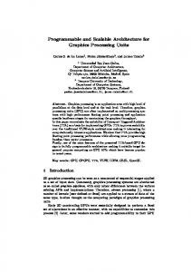
In our canonical tiling scheme for tiled feeds, the world map is recursively divided into four smaller tiles. The top-level tile is set to be the entire base map. This constitutes zoom level 0. We then divide the top-level tile into four equal square tiles, creating the tiles for zoom level 1. Each of the four new tiles in level 1 can be divided again, in four, to create 16 tiles in level 2. This process continues for each new level of resolution desired. We recommend a maximum of 20 levels, the same provided by most mapping services. Due to the properties of the Mercator projection1 , we restrict the base map to latitudes between 85.05112878 and 85.05112878 — the same restrictions used in both Google Maps and Bing Maps. This also conveniently creates a square map, which yields square tiles simplifies tile-based distance computations. For identification and linking purposes, an addressing value is assigned to each tile. Both the tiling and the addressing scheme are illustrated in Figure 1, with the world recursively divided and each area numbered 0 to 3. In essence, the top-left tile, covering the topleft sector of its parent tile, is always given a value of 0. The top-right tile is always given a value of 1, the bottom-left given 2, and the bottom-right is given 3. Thus, the tile key, a hash string that uniquely identifies a particular tile, is given by the concatenation of the Fig. 1. Quadtree-based tiling addressing values of its parent tiles. For ex- and addressing scheme ample: the key “0-1” identifies the top-right tile of the top-left tile of the base map. The length of its tile key represents the zoom level of the tile.
Tile Feeds Each tile is represented by an Atom feed, called the tile feed. The tile feed carries metadata information and descriptions similar to an ordinary Atom feed. The tile is referenced by a unique URI. For example, the tile representing the entire world would have an ID of http://example.com/feed/top. The northwestern tile at zoom level 1 would have an ID of http://example. com/feed/0. The tile feed links to neighboring, contained, and containing tiles, for RESTful navigation of the map. However, the tile feed is extended with some simple spatial properties. In particular, a tile feed has the following specific properties: – The atom:id element contains the URI for the tile. – Four atom:link elements point to the neighboring tiles. Links with the relations of north, south, east, and west point to the URIs of neighboring tiles 1
Singularities are present on both poles. The line at the top of a Mercator map, is in actuality a point — the north pole. The same applies for the line at the bottom of a Mercator map.
in the four cardinal directions. If there is no tile in that direction2 , the corresponding link element is omitted. – An atom:link element points to the containing parent tile. A link with the relation of up points to the URI of the tile one zoom-level up, which contains the current tile. – Four atom:link elements point to the tiles at the next zoom level, contained within the current tile. A link with the relation of down-northwest points to the URI of the tile at the northwestern quadrant, the down-northeast relation for the northeastern quadrant, down-southwest for the tile at southwestern quadrant, and down-southeast for the tile at the southeastern sector. With these extensions, subscribing clients of the tile feed can navigate the world using the provided links, load neighboring tiles, and retrieve information as needed. Each individual atom:entry in the tile feed consist of a resource available within this tile, representing some GIS feature and its attributes, written in KML or GML. For read-only feeds, these entries are refreshed when its back-end data source is updated. For writeable feeds, AtomPub may be used as a standard means for posting, editing, and deleting resource items within the feeds, creating more dynamic tile feeds. Features and attributes are provided by the underlying geographic information system. The system may be, for example, geographic information databases, third-party location-oriented services, or standardized GIS web services. We discuss the methods for integration with these data sources in more detail in Section 5. A tile feed may support paging, and does so according to the standardized feed paging mechanism [8]. A specific page is requested with a page query parameter in its URI, with a value equals to some positive integer representing desired page number. In this case, additional atom:link elements will point to the URIs of the previous, next, first, and last pages, as directed in the feed paging specification. More advanced operations, such as filtering, sorting, or querying, may also be supported; we discuss this in more depth in Section 5.
Implementation We have implemented proof-of-concept tiled feeds using freely available geospatial datasets and geospatial-aware relational databases. The popular PostgreSQL RDBMS can be augmented for GIS geometry columns and spatial query functions using the PostGIS3 add-on. GIS features were loaded into PostgreSQL tables, and a thin service layer is written to serve GIS features in the tiled feed format as described. We created, as tiled feeds, the locations and addresses of 861 Amtrak4 stations in the United States, the addresses and species of 64,318 street trees maintained or permitted by the city of San Francisco, and 25,928 magnitude 3.0+ earthquakes occurring in the United States in 2008. 2 3 4
For example, the tile 0 has no neighboring tile to its north. Available at http://postgis.refractions.net/ Amtrak is the sole intercity passenger rail service in the United States.