Eos,Vol. 81, No. 45, November 7,2000 EOS
T R A N S A C T I O N S
A M E R I C A N
G E O P H Y S I C A L
VOLUME 81
EOS
PAGES 529-544
PAGES 529,534-535 The Cariaco Basin, off the northeast coast of Venezuela, has long been the center of attention of scientists trying to explain paleoclimate.This peculiar anoxic basin records climate change over several dozen millennia within layers of sediment [Black eta!., 1999]. A joint U.S.-Venezuelan research effort launched in 1995—the Carbon Retention in a Colored Ocean (CARIACO) Program—pro vides a link between the sediment record and processes near the surface of the ocean for this basin. Sediment traps maintained by the pro gram show that over 5% of the organic carbon contained in particles formed near the surface through primary production (photosynthesis) by phytoplankton reaches 275 m depth, and nearly 2% reaches 1,400 m.This flux is significant, because it represents a sink for carbon diox ide, which is a greenhouse gas, and because it helps explain the record of ancient climate stored at the bottom of the Cariaco Basin. The CARIACO program has studied the rela tionship between surface primary production, physical forcing variables like winds, and the settling flux of particulate carbon in the Cariaco Basin for over 4 years.The basin, located on the continental shelf of Venezuela (Figure 1), shows marked seasonal and interannual variation in hydrographic properties and primary produc tion. Annual primary production rates exceed 500 gC m ,of which over 15-20% occurs during events lasting 1 month or less. 2
Such events are observed in other locations where time series observations are collected and suggest that earlier estimates of regional production based on limited sampling may have been underestimated.The annual primary production rates in the Cariaco Basin are com parable to those of Monterey Bay (460 gC m y ) , and they are higher than rates previously estimated for Georges Bank, the New York Shelf, and the Oregon Shelf (380,300, and 190 gC nv y , respectively). 2
The
NUMBER 45
NOVEMBER 7, 2000
Sediment Record Linked to Surface Processes in the Cariaco Basin
2
U N I O N
1
1
Cariaco Basin
The Cariaco Basin is -160 km long, 70 km wide, and 1,400 m deep. It is contained within the Venezuelan continental shelf (Figure 1) and
is bound to the north by a sill that connects Margarita Island to Cabo Codera at a mean depth of about 100 m with two channels breaching this sill (La Tortuga: -135 m and Centinela: -146 m). Because the sill restricts water motion and the lateral flux of material below about 140-m depth, Cariaco forms a natural sed iment trap within a continental shelf. The Cariaco Basin experiences marked sea sonal upwelling [Richards, \975; Muller-Karger andAparicio, 1994] that provides a source of nutrients that leads to vigorous phytoplankton growth near the surface. Figure 1 shows typical surface phytoplankton pigment distribution pat terns in a cold, upwelling plume. Much of this organic material remains ungrazed and sinks. As the turnover of basin waters is slow, the decomposition of the sinking material leads to permanent anoxia below about 275 m depth. Varved sediments that accumulate within the bottom anoxic waters then provide a detailed record of annual- to decadal-scale change over several dozen millennia.
chlorophyll-o estimates, and a transmissometer. Data are received continuously on a computer screen on board the ship as the device is low ered to the bottom of the Cariaco Basin at -1380 m. Water samples are analyzed for vari ous parameters, including phytoplankton biomass, dissolved and particulate nutrient and carbon concentration, and primary productiv ity rates. We also measure total bacterial pro duction. Winds are measured at Santiago Marino airport (10.9°N,63.96°W). To measure the flux of settling particles, we use four automated sediment traps placed at 275 m,455 m,930 m,and 1225 m on a mooring. These funnel-shaped traps are synchronized to collect samples over 2-week periods into a series of jars. The traps are retrieved and re deployed every May and November, and sam ples are used to estimate carbonate, organic carbon, nitrogen, and biogenic silica fluxes and various other geochemical parameters. Seasonal H y d r o g r a p h y , Productivity, and Settling Particulate C a r b o n Flux
The CARIACO program (http://paria.marine. usf.edu) was established in November 1995 through sponsorship of the National Science Foundation (NSF) and Venezuela's Consejo Nacional de Investigaciones Cientificas y Tecnologicas (CONICIT).This joint effort has involved five major Venezuelan institutions and three universities in the United States.The infra structure also contributes to the International Geosphere-Biosphere Programme's LandOcean Interactions in the Coastal Zone (IGBP/LOICZ) Program.
The zonal wind has shown marked seasonality over the past 4 years with values ranging from 4 m s between about August and January to 10 m s between about February and June (Figure 2). The meridional (north-south) component of the wind is weaker (0-1 m s ) than the zonal (eastwest) component and shows cyclic shifts with a period of about 3 months. Peak sea-surface temperatures of ~29.0°C are reached in September, and minima of about 23.0°C occur in March. In 1995^1996,1998-1999, and 1999-2000, isotherms warmer than about 21°C started to migrate upwards from about 130-m depth in October and November and reached 10-30-m depth in March through May Afterward, surface temperatures rose and the isotherms deepened. Features noted in the tem perature data (Figure 3, top) are evident in the other hydrographic parameters such as salinity (Figure 3, bottom).
Monthly oceanographic cruises to the CARIACO station (10.5°N,64.67°W) have been conducted since November 1995 to examine the hydrography, primary production, and set tling flux of particulate material.The program uses the 75-foot R/V Hermano Gines of the Fundacion La Salle de Ciencias Naturales (FLASA), located on Margarita Island,Venezuela.Water is collected with bottles that are closed automati cally at any depth via computer control.Twelve bottles are attached to a device called a con ductivity-temperature-depth (CTD) meter, which also has an oxygen probe, a fluorometer for
Surface salinities between August and Octo ber are fresher (< 36.5, coincident with the rainy season. In 1997-1998, upwelling was gen erally inhibited, possibly as a teleconnection to the strong El Nino-Southern Oscillation in the first part of that year, and only one month (March) showed significant upward migration of temperature and salinity isopleths. Wind speed has a seasonal cycle that general ly coincides with that of temperature, but under close examination, the wind can lag tempera ture by up to 3 months (Figure 3).At this time, there is no conclusive explanation for this
1
1
1
The
C A R I A C O Field P r o g r a m
Eos, Vol. 81, No. 45, November 7, 2000 spread in the phase lag in the wind and the lack of apparent correlation with it in the hydrography For the Caribbean Sea, one possi bility is that vertical displacement of the Sub tropical Underwater, a distinct water mass that enters the southern Caribbean, is controlled by seasonal changes in the geostrophic flow through the basin [Morrison and Smith, 1990]. We have found no clear evidence that shortterm variation over weeks to months is related to eddies moving west in the Caribbean Current. Such variation may be more closely related to small amplitude fluctuations (-1-2 m s ) in the meridional component of the wind. Within the Subtropical Underwater (SUW), nitrate concentration is 5-10 uM,and as this water is brought to the surface, it provides nutri ents that stimulate phytoplankton growth 1
[Walsh etai, 1999].Therefore,both chlorophyll-o concentrations and depth-integrated (0-100 m ) primary production change substantially with season. Production also changed in response to the strong hydrographic events of 1996-1997 and 1997-1998 (Figure 4). In general, annual production is estimated to be between 540-600 gC rrv y ,depending on the strength of short-lived upwelling events. However, in 1998, a rate of < 300 gC m y was estimated. The vertical flux of organic carbon measured with the sediment traps follows a regular pat tern; minima occur between September and January and maxima between February and May (Figure 4).The magnitude of the flux tends to decrease with increasing water depth, and similar temporal variability is observed at all four depths (Figure 4).The material reaching 2
1
2
20'
A V H R R (SST) 1 2 March 1 9 9 8
1
10'
66°
50'
40'
30
the bottom of Cariaco is rich in opal, carbon ate, and organic carbon, and lithogenic materi al accounts for -50% of the total annual particulate flux [Thunell et al, 2000]. Organic carbon flux generally shows a minimum of -0.01 gC m- d in January at all four trap depths. Flux increases in the subsequent 2 months and peaks in March at -0.17 gC m d at 275 m and about 0.06 gC m d at 1225 m. The 275-m trap usually exceeded the flux captured at 455 m by 20-200% during January through May, and frequently 200400% from July through November. However, in about 25% of the collections, the flux to the 455-m trap matches or slightly exceeds the flux observed in the shallowest (275-m) trap.The largest organic carbon flux recorded since 1995 was seen in the 1225-m 2
1
2
2
20'
10'
65*
50"
40'
30'
20'
1
10*
64°
SeaWiFS ( C h l o r o p h y l l a> 1 5 March 1 9 9 8
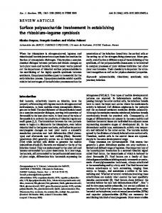
Fig. 1. (top) Charts showing the location of the Cariaco Basin and bathymetry of the basin, (bottom) Satellite images showing Sea Surface Temperature (AVHRR) and phytoplankton concentration (SeaWiFS) in the southeastern Caribbean Sea during March 1998 (upwelling period). The phytoplankton distribution near Margarita Island matches the spatial pattern of the cold Cariaco upwelling plume. The high pigment concentrations seen to the east trace the Orinoco River plume. Original color image appears at the back of this volume.
1
Eos,Vol. 81, No. 45, November 7, 2000
J FMAMJJ ASONDJ FMAMJJ ASONDJ FMAMJ J ASONDJ 1995 1996 1997 1998
J FMAMJ J ASONDJ FMAMJ J ASONDJ FMAMJ J ASONDJ 1995 1996 1997 1998
J FMAMJ JASONDJ FMAMJ JASONDJ FMAMJ J A S O N D J 1995 1996 1997 1998
J F M A M J J A S O N D J FMAMJ JASONDJ FMAMJ J A S O N D J 1995 1996 1997 1998
Fig. 2. (top to bottom) Wind (v, u, and scalar speed [m s- ]) at Santiago Marino airport (Margarita Island). Broken line laid over the scalar wind graph represents the monthly mean scalar wind. Negative u and v values represent westward and southward winds, respectively, (bottom) AVHRR-SST in a 12x12 km area centered at the Cariaco site. Heavy line overlay connecting small squares represents CARIACO (in situ) temperature at 1-7 m depth.
depth. Since this model was developed from observations from an open, oxygenated Pacific Ocean environment, our results suggest that organic matter degradation in the anoxic Cari aco Basin is as efficient as that occurring in well-oxygenated waters [Thunell et a/.,2000]. An important discovery is that most of the bacterial production occurs in the upper 275 m.Only 4-37% of integrated bacterial produc tion (mean = 17%; SD = 11) occurs below the depth of the shallowest sediment trap (275 m ) . Indeed, the sediment trap data imply that on average, 95% of the labile export production is consumed or regenerated at depths shallower than 275 m. However, organic carbon delivery to the 455-m trap exceeded that delivered to the 275-m trap in -25% of our observations. Fur thermore, on average, we observe as much, and frequently more, bacterial production between 275-450 m, below the oxic-anoxic interface (17% integrated bacterial production),than in the 175 m immediately above this depth (14% integrated bacterial production). This demonstrates that the oxic-anoxic inter face is a region of vigorous carbon cycling. We propose that this carbon is not entirely provided by surface-derived export production. While bulk carbon delivery to the deepest trap appears to conform to open water predictions,
the composition and source terms for this material are not well-defined. Rapid heterotrophic activity at the oxic-anoxic inter face suggests introduction of fresh labile organic matter at depth either through verti cal migrators or possibly through in situ pro duction by chemoautotrophs. High rates of dark, dissolved inorganic carbon (DIC) assim ilation by chemoautotrophic bacteria have been measured below the oxic-anoxic inter face (between 275 m and 455 m ) equivalent to 10-333% of contemporaneous estimates of integrated primary production. The trap and primary productivity observa tions suggest, then, that between 10-11 gC mare delivered to the bottom sediment of Cariaco every year.This agrees well with rates seen at other continental margin locations [Thunell, 1999]. If these rates apply over the upwelling plume that covers the Cariaco Basin and adja cent areas (Figure 1), between 4 x 10 and 1 x 10 mT of C y may be delivered to sediments of the southeastern Caribbean Sea due to this upwelling system alone. The final question is, what is the source of the C 0 that ends up in sediment carbon deposits of the Cariaco Basin system? In open ocean surface water, phytoplankton photosynthesis tends to decrease near-surface 2
5
6
1
2
1
N o v 95 F e b 96 M a y 96 A u g 96 D e c 96
M a r 97
Jun 97
O c t 97
Jan 98
A p r 98
A u g 98
2
trap sample in early July 1997.This flux was associated with a turbidite generated by an earthquake that occurred along the Venezuelan coast.This event was described by Thunell et al. [1999]. Implications for Estimates of Flux The results from the CARIACO time series site demonstrate that production along conti nental margins in the tropics can be substan tial and redefine earlier estimates as being minimum values. Our annual production esti mates (>500 gC nv y ) are significantly higher than those reported previously from near the Cariaco Basin (200-400 g C m y ; see MullerKarger et al, 1989). Vertical carbon flux is directly proportional to this integrated production. Carbon flux at 275 m is on average 5.6% of integrated primary production. This decreased to 5.1% at 455 m, although in February, March, and April 1996 it was 6-7% at both 275 m and 455 m.The average proportion decreased to 2.8% at 930 m and to 1.7% at 1225 m. Observed carbon fluxes are in excellent agreement (r = 0.87) with predicted fluxes determined using the Pace et al. [1987] model. This model prescribes the vertical profile of organic carbon flux as an exponential decay function based on surface production and 2
I
I
i
[
I
I
I
I
I
I
I
i
I
i
I
I
I
I
I
1
I
I
I
I
I
I
I
1 I
I
I
l
l
8 0 140 2 0 0 2 6 0 3 2 0 3 8 0 4 4 0 5 0 0 560 6 2 0 6 8 0 7 4 0 800 860 9 2 0 9 8 0
Nov-95 Feb-96 May-96
Aug-96
Time(d) D e c - 9 6 M a r - 9 7 Jun-97 I.
.1..
Oct-97 .1,
™ Jan-98 A p r - 9 8 A u g 4
.,.
I.
1
1
2
2
I
20
1
-400
\ 1 1 1 1 1 1 1 1 1 1 1 1 1 1 1 1 1 1 1
20
[ 1 1 1 1 1 1 1 1 1 1 1 1 1 1 1 1 1 1 1 1 1 1 1 1 1 1 1 1 1 1 1 1 1
ii n n 111111 n
ii 11111111111 u 111111 M 111111111
80 140 200 260 320 380 440 500 560 620 680 7 4 0 800 860 920 980
Time (d) Fig. 3. (top) Variation in the temperature (C) at the CARIACO Time-series station between November 1995-August 1998. (bottom) Salinity.
Eos,Vol. 81, No. 45, November 7,2000 OCE-9729284, OCE-9401537, OCE-9729697, OCE-9415790,and OCE-9711318),NASA (grants NAG5-6448 and NAS5-97128),and the Consejo Nacional de Investigaciones Cientfficas y Tecnologicas (CONICIT,Venezuela, Grant 9628022l).We are indebted to the personnel of the Fundacion La Salle de Ciencias Naturales, Estacion de Investigaciones Marinas Isla Margarita (FLASA/EDIMAR) for their enthusi asm and professional support. In particular, we thank Pablo Mandazen for his confidence in our activities and the crew of the R/V Hermano Gines for their able support at sea. Jonnathan Garcia, Javier Gutierrez, Anadiuska Rondon, John Akl,and Ana Lucia Odriozola provided essential field and laboratory support. Luis Troccoli,Wilfredo Patino, Luis Sanchez, and William Senior provided nutrient data. The Biotechnology Laboratory of Empresas Polar in Caracas,Venezuela, allowed access to their scintillation counter for primary productivity assessments. State University of New York (Stony Brook) Marine Sciences Research Center contribution number 1194.
Us 1
N'D| J F'M'AWJ'J'A'S'O'N'DI J
Trap B - 475m
N I D I J I F I M I A I M U J I A I S I O M D| J I Fl
Authors 0 20
LU
CO
6cn
0 .12 0 08
O
0 04 0 00
N'DIJ'F'JA'M'J'JWO'N^
0 20
Ll_
J
Trap D - 1255m
0 16
x
_a
Frank Muller-Karger, Ramon Varela, Robert Thunell, Mary Scranton, Richard Bohrer, Gordon Taylor, Juan Capelo, Yrene Astor, Eric Tappa, Tung-Yuan Ho, Maria Iabichella, John J. Walsh, and Jose Rafael Diaz For more information, contact Frank MullerKarger, College of Marine Science, University of South Florida, St. Petersburg, Fla. 33701 USA; E-mail:
[email protected]
Trap C - 900m
0 16
X
_2
>» CO T3
6 *E o
0 12
References
0 08
Acknowledgments
Black, D. E., L. C. Peterson, J.T. Overpeck, A. Kaplan, M. N. Evans, and M. Kashgarian, Eight centuries of North Atlantic Ocean atmosphere variability, Science,286,1709-1713,1999. Morrison, J. M.,and O. PSmith,Geostrophic transport variability along the aves ridge in the eastern Caribbean Sea during 1985-1986,7. Geophys. Res., 55,699-710,1990. Muller-Karger, HE.,and R.Aparicio, Mesoscale processes affecting phytoplankton abundance in the southern Caribbean Sea, Cont. Shelf Res., 14, 199-221,1994. Muller-Karger, FE.,C. R. McClainJ. R. Fisher, W E. Esaias, and R.Varela, Pigment distribution in the Caribbean Sea: Observations from Space, Prog. Oceanogr., 23,23-69,1989. Pace, M., G. Knauer, D. Karl, and J. Martin, Primary production, new production and vertical flux in the eastern Pacific Ocean, Nature, 325,803-^804,1987. Richards, EA.,The Cariaco Basin (trench), Oceanogr. Mar. Biol. Ann. Rev., 13,11-67,1975. Thunell, R. E., R. Tappa., M.Varela,Y Llano, E Astor, EE. Muller-Karger, and R. Bohrer, Increased marine sed iment suspension and fluxes following an earth quake, Nature, 398,233-236,1999. Thunell, R., R. Varela, M. Llano, J. Collister, EE. MullerKarger, and R. Bohrer, Organic carbon flux in an anoxic water column: Sediment trap results from the Cariaco Basin,Limnol. Oceanogr., 45,300-308, 2000.
This work was supported by the National Science Foundation (NSF Grants OCE- 9216626,
Walsh, J. J., et al., Simulation of carbon/nitrogen cycling during spring upwelling in the Cariaco Basin, J. Geophys. Res., 104,7807-7825,1999.
0 04 0 00
[MIJIJIAISIOIN1D|JIFI 1996 2
Fig. 4. (Top graph) Cariaco Basin primary production integrated over the upper 100 m [g C m d ]. (Lower four graphs) Settling flux of particulate carbon [g C m d ] at four depths. Samples for the second trap deployment (May-November 1996) were lost, as the traps clogged after deployment. This was caused by a plankton bloom in May 1996, which had the highest primary productivity measured during the last 4 years. 1
2
fugacity of C0 , resulting in a net flux from the atmosphere into the ocean. However, in a system like the Cariaco Basin, the upwelling process brings deep water enriched in DIC to the sur face, and fugacity of C 0 increases as the water enters the euphotic zone. In the Cariaco Basin, near-surface fugacity values during August through October were typically in the 390405 uatm range. During January through May val ues were in the 360-390 uatm range.Thus, the ocean remained near or above the atmospher ic saturation partial pressure (-365 uatm) near ly at all times, in spite of the high primary production and high carbon export in the form of sinking organic particulate flux. 2
2
Viewed as a purely vertical system, the Caria co upwelling system is a source of C 0 to the atmosphere on a year-round basis.This is 2
1
important, since intensification of the "biologi cal pump" is often considered to be a key mechanism for drawing down atmospheric C0 . However, the significance of the downward flux of particulate carbon at this continental margin lies in its role as a sink for C 0 captured within the North Atlantic and transported via subsurface water masses.The SUW is a source of new nutrients as well as of new C0 .We may extend this analogy to other continental margins and view coastal upwelling areas as both nutrient traps as well as areas of C 0 outgassing. 2
2
2
2
Eos,Vol. 81, No. 45, November 7,2000
AVHRR (SST)
SeaWIFS (Chlorophyll a)
1 2 March 1 998
1 5 March 1 998
Fig. I. (top) Charts showing the location of the Cariaco Basin and bathymetry of the basin. (bottom) Satellite images showing Sea Surface
Temperature (AVHRR) and phytoplankton concentration (SeaWiF.S') in the southeastern Caribbean Sea during March 1998 (upwelling period). The phytoplankton distribution near Margarita Island matches the spatial pattern of the cold Cariaco upwelling plume. The high pigment concentrations seen to the east trace the Orinoco River plume.
Page 529