Atmos. Chem. Phys., 10, 3443–3453, 2010 www.atmos-chem-phys.net/10/3443/2010/ © Author(s) 2010. This work is distributed under the Creative Commons Attribution 3.0 License.
Atmospheric Chemistry and Physics
Sediment records of highly variable mercury inputs to mountain lakes in Patagonia during the past millennium S. Ribeiro Guevara1 , M. Meili2 , A. Rizzo1,3 , R. Daga1,3 , and M. Arrib´ere1,4 1 Laboratorio
de An´alisis por Activaci´on Neutr´onica, Comisi´on Nacional de Energ´ıa At´omica, Centro At´omico Bariloche, 8400 Bariloche, Argentina 2 Department of Applied Environmental Science, Stockholm University, 106 91 Stockholm, Sweden 3 Consejo Nacional de Investigaciones Cient´ıficas y T´ ecnicas, Rivadavia 1917, Ciudad de Buenos Aires, Argentina 4 Instituto Balseiro, Universidad Nacional de Cuyo, 8400 Bariloche, Argentina Received: 15 September 2009 – Published in Atmos. Chem. Phys. Discuss.: 2 December 2009 Revised: 26 March 2010 – Accepted: 6 April 2010 – Published: 14 April 2010
Abstract. High Hg levels in the pristine lacustrine ecosystems of the Nahuel Huapi National Park, a protected zone situated in the Andes of Northern Patagonia, Argentina, have initiated further investigations on Hg cycling and source identification. Here we report Hg records in sedimentary sequences to identify atmospheric sources during the past millennium. In addition to global transport and deposition, a potential atmospheric Hg source to be considered is the local emissions associated with volcanic activity, because the Park is situated in the Southern Volcanic Zone. Two sediment cores were extracted from Lake Tonˇcek, a small, highaltitude system reflecting mainly direct inputs associated with atmospheric contributions, and Lake Moreno Oeste, a much larger and deeper lake having an extended watershed covered mostly by native forest. The sedimentary sequences were dated based on both 210 Pb and 137 Cs profiles. In addition, tephra layers were identified and geochemically characterized for chronological application and to investigate any association of volcanic eruptions with Hg records. Hg concentrations in sediments were measured along with 32 other elements, as well as organic matter, subfossil chironomids, and biogenic silica. Observed background Hg concentrations, determined from the sequence domains with lower values, ranged from 50 to 100 ng g−1 dry weight (DW), whereas the surficial layers reached 200 to 500 ng g−1 DW. In addition to this traditional pattern, however, two deep domains in both sequences showed dramatically increased Hg levels reaching 400 to 650 ng g−1 DW; the upper dated to the 18th to 19th centuries, Correspondence to: S. Ribeiro Guevara (
[email protected])
and the lower around the 13th century. These concentrations are not only elevated in the present profiles but also many-fold above the background values determined in other fresh water sediments, as were also the Hg fluxes, reaching 120 to 150 µg m−2 y−1 in Lake Tonˇcek. No correlation was observed between Hg concentrations and the contents of organic matter, subfossil chironomids, biogenic silica, or the other elements determined. However, distinctly increased Hg concentrations were observed immediately above some tephra layers, suggesting a link to volcanic events. Extended fires might be another potential atmospheric source because the earlier Hg peaks coincide with reported charcoal peaks, whereas the upper Hg peaks coincide with evidences of extended forest fires from tree-ring data and historical records.
1
Introduction
Even though aquatic ecosystems are globally exposed to mercury (Hg) by atmospheric inputs of increasing concern, few studies have been focusing on the sources, fate and history of freshwater systems of the southern hemisphere that are free from major contamination (Downs et al., 1998; Lamborg et al., 2002; Biester et al., 2007). Here, we used sediment profiles as historical archives to reveal changes in the Hg cycling in two lakes of the southern Andes over the past centuries. Although no relevant point source of Hg from mining or industrial activities has been identified in the study region, high Hg levels in various ecosystem compartments have been reported, notably in both native and introduced fish species, where levels ranged from 0.06 to 4 µg g−1 dry weight (DW) in liver, and from 0.07 to 2.5 µg g−1 DW in
Published by Copernicus Publications on behalf of the European Geosciences Union.
3444
S. Ribeiro Guevara et al.: Sediment records of highly variable mercury inputs
muscle (Arrib´ere et al., 2008), whereas Hg concentrations in lichens and mussels, used as air and water bioindicators respectively, were compatible with those at locations exposed to moderate contamination (Ribeiro Guevara et al., 2004a; Ribeiro Guevara et al., 2004b), suggesting that the anomaly is not limited to aquatic systems. The western part of the Park receives high precipitation, reaching 3000 mm y−1 . Therefore, global transport and wet deposition, a well-known Hg source to aquatic environments (Downs et al., 1998), should be considered to contribute to the Hg burden in the study region. But other Hg sources have to be taken into account. Forest fires, volcanoes and geothermal vents, and Hg-enriched soils have been recognized as natural Hg sources to the atmosphere (Nriagu, 1989; Lindqvist et al., 1991; Schroeder and Munthe, 1998; Wiedinmyer and Friedly, 2007). Geological sources are associated with plate tectonic boundaries (Varenkamp and Brusek, 1984; Rasmussen, 1994), including areas of geothermal and volcanic activity, which are considered as the foremost natural source of Hg (Nakagawa, 1999; Ferrara et al., 2000; Tomiyasu et al., 2000). Cataclysmic volcanoes have the potential to inject enough volatile Hg into the stratosphere to change the global and regional cycle of Hg for a few years, while quiescent degassing and moderate eruptions exhale directly into the troposphere and can also have long-term effects on the local environments (Langway et al., 1995). Geothermal activity has been associated with high Hg levels in soils and air at several places (Siegel and Siegel, 1975; Weissberg and Rohde, 1978; Varenkamp and Buseck, 1986). Volcanogenic Hg can readily enter the aquatic food chain after being released, enlarging bio-available stocks (Nriagu and Becker, 2003). Volcanic activity is a potential source to be considered in the present work because the lakes under study are within the Southern Volcanic Zone (SVZ) (Stern, 2004), including several volcanoes active during the Holocene. Forest fires can drastically reduce the pool of Hg in catchment soils and release biomass inventories because of volatilization of elemental Hg to the atmosphere (Friedli et al., 2003; Sigler et al., 2003; Amirbahman et al., 2004, Harden et al., 2004), potentially enlarging sediment Hg burden by transport and wet or dry deposition. Up to 6 fold increase in Hg concentrations in sediments of Caballo Reservoir, New Mexico, USA, was observed after a forest fire and storm runoff, suggesting that the combination of both phenomena enhanced the transport of Hg from the watershed to the water body (Caldwell et al., 2000), and might contribute to increasing Hg contents in sediments after fires. Kelly et al. (2006) observed a large short-term pulse of Hg mobilized by post-fire runoff in Lake Moab, Jasper National Park, Canada. In an earlier screening research on lake sedimentary sequences in the study region (Ribeiro Guevara et al., 2005), upper layers, associated with 20th century accumulation periods, showed in most cases concentrations elevated above background levels, reaching values as high as 1 to 3 µg g−1 DW. However, Hg concentrations 3 to 5-fold above backAtmos. Chem. Phys., 10, 3443–3453, 2010
ground levels (0.1 to 0.2 µg g−1 DW) were observed in deep layers, focusing hence our attention on natural inputs during the past millennium, and driving present work. Here, two dated sedimentary sequences were studied with a more sensitive technique for Hg determinations (Instrumental Neutron Activation Analysis was used in previous works), and with additional methods to analyze other selected elements and environmental tracers.
2 2.1
Experimental Study site
The Nahuel Huapi National Park is situated in Northern Patagonia, on the eastern slope of the southern Andes (40◦ 200 to 41◦ 400 S, 71◦ to 72◦ W; Fig. 1) and is the largest protected natural area of Argentina, covering approximately 7100 km2 and comprising a drainage basin that includes three major river systems, thirteen lakes of more than 10 km2 , and several hundred small lakes and ponds. Within the Park’s limits there are pristine as well as moderately impacted areas, such as the city and suburbs of San Carlos de Bariloche, with a population of circa 120 000 people. Its economy, as well as that of other small towns and villages in the Park, is largely based on tourism. The Park is located in the Northern Patagonian Andes (39◦ to 45◦ S), a region that is part of the Southern Volcanic Zone (SVZ). The SVZ includes at least 60 historically and potentially active volcanic edifices in Chile and Argentina, three giant silicic caldera systems and numerous minor eruptive centers (Stern, 2004). The Northern Patagonian segments of the volcanic arc include several centers which are active since the Miocene to present (Villarrica, Nilahue, Puyehue-Cord´on Caulle, Cerro Puntiagudo, Osorno, and Calbuco, among others), with several events registered in historical records since the Spanish colonisation (Ramos, 1999; Stern, 2004). An analysis of volcanic ash records in short lacustrine sedimentary sequences from this region showed up to 9 tephra layers deposited in the past 1000 years (Daga et al., 2008). Two sedimentary sequences were extracted from Lake Moreno Oeste and Lake Tonˇcek (Fig. 1). Lake Moreno Oeste is the western branch of Lake Moreno (41◦ 50 S; 71◦ 330 W, 758 m above sea level), draining into Lake Nahuel Huapi. Lake Moreno Oeste has a surface area of 6 km2 and a maximum depth of 90 m, and is an ultraoligotrophic, warm monomictic system stratified from late spring to early autumn (Queimali˜nos et al., 1999; D´ıaz et al., 2007). The lake is surrounded mostly by closed native forest dominated by Nothofagus dombeyi and lesser amounts of Austrocedrus chilensis. This environment has persisted, with variations in the relative composition, during the last millennium (Whitlock et al., 2006). The sampling point is located at Llao Llao www.atmos-chem-phys.net/10/3443/2010/
S. Ribeiro Guevara et al.: Sediment records of highly variable mercury inputs
3445
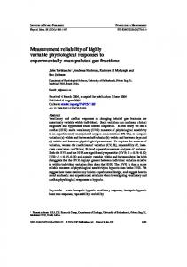
Fig. 1. Study area. Section of Nahuel Huapi National Park, Northern Patagonia, Argentina.
bay, a sub-basin with a rather flat bottom at 20 m depth, without tributaries. Lake Tonˇcek (41◦ 120 S; 71◦ 290 W, 1750 m above sea level) is a small lake with 0.03 km2 surface area and 12 m maximum depth, of glacial origin, situated in Catedral mountain approximately 16 km to the south of Lake Moreno Oeste, at the foot of high peaks with steep slopes. It is an ultraoligotrophic, dimictic system, with direct stratification in summer and 6 to 8 months of ice cover reaching a thickness of up to 2 m. Lake Tonˇcek watershed is small, with an extension of approximately 2.5 km2 including one smaller lake situated about 100 m higher, which is connected to Lake Tonˇcek by a small inlet stream meandering across wetlands. Reddish coloration and sulphydric smell in these wetlands have been reported at the end of the summer, when eutrophication processes are developed, potentially impacting Hg cycling in the water body. The lake has two distinct sections: a deep central zone that is surrounded like a ring by a shallow outer zone which is 0.5 m deep and up to 30 m wide. The boundary between the two sections is a steep www.atmos-chem-phys.net/10/3443/2010/
slope dropping to 12 m. Lake Tonˇcek watershed is dominated by rocky ground deposits, and scattered timberline forest (Nothofagus pumilio “krummholz”) and high-Andean vegetation (Gaultheria pumila and Baccharis magellanica). The water body encloses a simple trophic structure without fish, and the community structure of zooplankton is relatively simple (Morris et al., 1995; Marinone et al., 2006). 2.2
Methods
Short sediment cores were extracted with a messengeractivated gravity corer from the deepest part of the lakes Moreno Oeste (Llao Llao bay) and Tonˇcek (Fig. 1). Core lengths were 43 and 70 cm for Lake Moreno Oeste, and Lake Tonˇcek, respectively. The sediment cores were cut opened longitudinally using a portable circular saw to section the tube walls, sliding afterwards a copper plate through the sediment to divide it into two semi-cylindrical sections. Both sections were sub-sampled every 1 cm. Each sub-sampled sediment layer was freeze-dried until constant weight and homogenised. Tephra layers were identified visually in the Atmos. Chem. Phys., 10, 3443–3453, 2010
3446
S. Ribeiro Guevara et al.: Sediment records of highly variable mercury inputs
sedimentary sequence before sub-sampling, whereas they were analyzed under binocular magnifying glass after freezedrying. The sediment accumulation rates of the sediment sequences were determined by 210 Pb and 137 Cs dating techniques (Joshi and Shukla, 1991; Robbins and Herche, 1993; Ribeiro Guevara and Arrib´ere, 2002). 210 Pb, 226 Ra (in secular equilibrium with supported 210 Pb), and 137 Cs specific activity was measured in each layer by high-resolution gamma spectrometry. The Constant Rate of Supply model was used for 210 Pb dating. Correction of the old-date error of the model was implemented by logarithmic extrapolation to infinite depth (Ribeiro Guevara et al., 2003). For 137 Cs dating, the specific activity profiles were compared with the fallout sequence determined in this region, associated mainly with South Pacific nuclear tests from 1966 to 1974 (Ribeiro Guevara and Arrib´ere, 2002). The dates for the events registered in the sedimentary sequences before 1900 were obtained by extrapolation of the sedimentation rate determined in the upper layers. The extrapolation was computed in depth units of cumulative mass per surface unit, discounting volcanic ashes from bulk sediments by estimating the fraction in each layer from the analysis under binocular microscope. The organic matter content (OM) of the freeze-dried sediments was estimated as loss on ignition (LOI) at 550 ◦ C for 4 h. Total Hg was analyzed by atomic absorption spectrometry directly after high-temperature combustion and catalytic reduction using a Milestone Direct Mercury Analyser (DMA 80, Milestone Inc., Monroe, CT, USA, http://www.milestonesci.com/mercury-dma.php) according to the US-EPA Method 7473 (US-EPA, 2007), and following the quality assurance routines of the laboratory at ITM as specified under Swedish Accreditation (SWEDAC Nr. 1295, Swedish Board for Technical Assistance, http://www. swedac.se). Samples were frequently replicated (up to fourfold), and blanks and certified standard reference materials (here GBW07405/NCS DC 73323) were analyzed daily to assure adequate performance and accuracy. Detection limit (3 SD of blanks) for the applied procedure was 100 ng g−1 DW) was 2% in homogenous reference samples and 4% in actual samples. Total Hg was determined in bulk sediment except for tephra layers, where the