Error (HPE) due to a single marginally detectable blunder as a measure of ..... entage of HP. E s.
Simulated Performance of Multiple-signal and Multiple-system Positioning for Land Vehicle Navigation Wei Cao, Kyle O’Keefe, Mark Petovello and M. Elizabeth Cannon Position, Location And Navigation (PLAN) Group Department of Geomatics Engineering Schulich School of Engineering University of Calgary BIOGRAPHIES Wei Cao is an MSc. student of Geomatics Engineering at the University of Calgary. He obtained his Bachelors and Masters degrees in Geodesy and Geomatics Engineering from Wuhan University in China in 2004 and 2006. His current research interest is GPS and GALILEO integrated positioning. Kyle O’Keefe is an Assistant Professor of Geomatics Engineering at the University of Calgary. He completed PhD and BSc. degrees in the same department in 2004 and 2000. He has worked in positioning and navigation research since 1996 and in satellite navigation since 1998. His major research interests are GNSS system simulation and assessment, space applications of GNSS, carrier phase positioning, and local and indoor positioning with ground based ranging systems Mark Petovello is an Assistant Professor in the Position, Location and Navigation (PLAN) group in the Department of Geomatics Engineering at the University of Calgary. Since 1998, he has been involved in various navigation research areas including software receiver development, satellite-based navigation, inertial navigation, reliability analysis and dead-reckoning sensor integration. M. Elizabeth Cannon is Dean, Schulich School of Engineering and Professor, Department of Geomatics Engineering at the University of Calgary. She has been involved in GPS research and development since 1984. She has worked extensively on the integration of GPS and inertial navigation systems. Dr. Cannon is also a Past President of the Institute of Navigation (ION) and is Past Chair of the ION Satellite Division. ABSTRACT The modernized GPS and planned GALILEO will provide civil users with multiple signals (or frequencies). In this paper, the navigation performance based on code and phase measurements is investigated for land vehicle users in the continental United States and Southern Canada. For code-based positioning, the availability, accuracy and reliability are estimated with different signal scenarios for
GPS, GALILEO and their combined systems through software simulation. The simulation results are presented using Horizontal Dilution of Precision (HDOP) as a measure of availability and accuracy and maximum Horizontal Position Error (HPE) due to a single marginally detectable blunder as a measure of reliability. It is shown that the future GNSS signals demonstrate better performance than the legacy signals while the GPS/GALILEO combined system offers a great improvement in terms of reliability. For phase-based positioning, the reliability of integer ambiguity resolution in terms of probability of correct fix is studied and analyzed for various frequency and system combinations. It is shown that GALILEO has better performance compared to GPS within the same baseline and identical ionospheric and tropospheric conditions when single-, dual- and triple-frequency receivers are simulated, respectively. The combination of two systems has even further advantages: use of dual-frequency GPS/GALILEO together outperforms triple-frequency GPS or GALILEO alone in terms of time required for the float ambiguity solution to converge to a given level of probability of correct fix. INTRODUCTION With the modernization of GPS and the deployment of GALILEO, multiple signals (frequencies) will be available for civil users from both systems. For GPS, there will be four civil signals – L1 C/A, L2C, L5, and L1C transmitted on three frequencies to users; with respect to GALILEO, there will be even more, ten signals broadcasted on four frequencies – E1, E5a, E5b and E6 (ESA&GJU, 2006). The two systems together will provide about twice the number of satellites compared to the current GPS and this will significantly improve satellite availability, thus there will be greater opportunities for satellite-based vehicle navigation, especially in degraded environments, such as urban canyons and high multipath conditions. At the same time, enhanced satellite availability and improved signal performance will enhance integrity levels for land vehicle navigation. The performance of Global Navigation Satellite Systems (GNSS) can be quantified by availability, accuracy and reliability. The availability is referred to the number of satellites observed by the users. Accuracy is a measure of how
ION NTM 2008 Session A3, San Diego, CA, January 28 – 30
Page 1 of 10
As to reliability, there are different measures for code and phase-based positioning. In this paper, for code-based positioning, reliability refers to the ability to detect a blunder in the measurements and to estimate the effect of an undetected blunder on the navigation solution. It is assumed that there is only one blunder at one epoch. The effect of one undetectable blunder can be determined by evaluating the effect of each marginally detectable blunder (MDB) on the navigation solution as follows (further details is given in Ryan et al, 2000), (1) Δx = −( AT C −1 A) −1 AT C −1∇ l
l
where A is the design matrix, Cl is the covariance matrix of the observations, ∇ is a column vector of zeros except for the ith row which contains the marginally detectable blunder of ith observation. For phase-based positioning, reliability is referred to the probability of correct fix (PCF) in integer ambiguity resolution (Verhagen, 2005). Evaluating the probability of correct fix when using integer least squares has been shown to be difficult and thus the probability of correct fix using integer bootstrapping is often used to provide a lower bound on the probability of correct fix. The evaluation of PCF is based on the following expressions, n (2) 1 ( P( xB = x) = ∏ (2Φ( ) − 1) 2σ xˆi|I i =1 1 2π
Φ(x ) =
x
∫e
1 − n2 2
dn
(3)
−∞
(
where x B is the bootstrapped integer ambiguity vector,
σ xˆ is the conditional standard deviation of ambiguity i conditioned on the previous I = (1,2,..., i − 1) ambiguities, i| I
and Φ( x ) describes the area under the normal distribution.
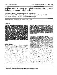
The GALILEO constellation will consist of 30 MEO satellites in 3 orbital planes inclined at 56 degrees at a 23616 km altitude above the Earth (Zandbergen et al, 2004). In the simulation, the satellites are assumed to be equally spaced in each plane. The planes are equally spaced in terms of right ascension of ascending node and the satellites in the second and third planes are advanced by 12 and 24 degrees in argument of latitude with respect to the first plane. The ascending nodes of the three orbital planes of the simulated GALILEO constellation were arbitrarily assigned right ascensions of 0, 120 and 240 degrees respectively. The relative orientation of the GALILEO constellation with respect to the GPS constellation has not yet been determined. For fair comparison, we use the real GPS constellation is used for the simulation which consists of 30 satellites. It started at the beginning of GPS week 1446 (September 30, 2007) and the actual GPS almanac from that week was used. The simulated GPS and GALILEO constellations are shown in Figure 1. Arguement of Perigee + Mean Anomaly, ω + M, (degrees)
close the navigation solution provided by the system is to the true position and/or velocity of the user. Generally, the accuracy of a navigation system can be decomposed into two quantities: user equivalent range error (UERE) and dilution of precision (DOP). UERE is obtained by mapping all of the system and user errors into a single error in one user measured range. DOP values are good measure of system availability as they represent the geometric strength of the system; they can also be used to represent accuracy when it is assumed that range measurements from all satellites have the same UERE. For land-based navigation, Horizontal DOP (HDOP) is a good measure of availability and accuracy.
Simulated GPS and Galileo Constellation at 0h00 UT, September 30, 2007 18 55 GPS 64 28 330 22 45 GALILEO 54 63 300 9 11 44 53 270 17 14 62 43 52 240 1 61 12 20 42 5 210 51 30 460 31 41 180 50 2 23 59 150 40 49 13 76 58 120 16 39 48 10 24 90 57 25 38 21 27 47 60 56 3 37 8 30 29 46 26 65 19 0 36 -180 -150 -120 -90 -60 -30 0 30 60 90 120 150 180 Right Ascension of Ascending Node, Ω , (degrees) 360
Figure 1: Combined GPS and GALILEO constellation on September 30, 2007 (GPS PRN: 1~30, GALILEO PRN: 36~65)
PESUDORANGE POSITIONING SIMULATIONS UERE Determination As mentioned above, the UERE values can be used to represent the system availability, accuracy and reliability. The first important task is to determine the UERE values with different GNSS signals. While no official documents on the range accuracy of future GPS and GALILEO signals were available, there were studies to quantify the signal performances of future GNSS systems (McDonald & Hegarty, 2000; Rodríguez et al, 2004, 2005, 2006). Following Rodríguez et al (2004), the error sources can be divided into three groups: (1) satellite errors – clock bias and orbital errors; (2) signal propagation errors – ionospheric and tropospheric refraction, multipath; (3) receiver errors – receiver noise and receiver clock bias. The broadcast ionospheric models, Klobuchar model for GPS and NeQuick model for GALILEO, are used for ionospheric correction of about 50% of the total error with the remainder
ION NTM 2008 Session A3, San Diego, CA, January 28 – 30
Page 2 of 10
Table 1: UERE values of future GNSS signals GPS GALILEO L1 L2C L5 L1C E1 E5a C/A Orbital error (m) Residual ionospheric errors (m) Residual tropospheric errors (m) Receiver noise (m) Code multipath (m) UERE
2.00
1.20
0.60
0.60
0.60
0.60
3.25
5.35
5.83
3.25
3.25
5.83
0.20
0.20
0.20
0.20
0.20
0.20
0.61
0.40
0.06
0.19
0.19
0.02
0.60
0.60
0.40
0.20
0.20
0.40
3.92
5.53
5.88
3.32
3.32
5.88
Simulation Parameters Twenty-four hour simulations were performed to evaluate the following scenarios which have been classified into four groups. (1) Use of a single frequency signal from a single GNSS system, a. GPS L1 C/A code b. GPS L2C code c. GPS L5 code d. GPS L1C code e. GALILEO E1 code f. GALILEO E5a code (2) Use of a single frequency signal from combined systems, g. GPS & GALILEO L1(E1) code h. GPS L5 & GALILEO E5a code (3) Use of dual-frequency signals from a single system, i. GPS L1C/A & L2C code j. GPS L1C/A & L5 code (4) Use of WAAS ionospheric corrections, k. GPS L1 C/A code l. GPS L2C code m. GPS L5 code n. GPS L1C code o. GALILEO E1 code p. GALILEO E5a code q. GPS & GALILEO L1(E1) code r. GPS L5 & GALILEO E5a code The UERE values for all the scenarios above were determined. When using dual-frequency signals from a
single system, the ionospheric error is mitigated while the tropospheric error is amplified. When the external ionospheric corrections from WAAS are used, the residual ionospheric error is set to a conservative value of 0.8 m. Only the results in group (1) and (2) are shown in this paper. Simulation
locations were selected from o 25 ~ 50 N ,60 ~ 130 E with 5° spacing resulting 90 points roughly covering the populated regions of the United States and Canada and including nearby oceans. The simulation points are shown in Figure 2. Various satellite masking angles of 0, 10, 20, 30, and 40 degrees are employed. A zero degree mask angle is representative of a land vehicle user with a clear view of the sky. On the other hand, a 40 degree mask angle could represent a user in an urban canyon with a very limited view of the sky. For the land vehicle users, a height constraint could be applied using a digital terrain model, or a simple mean local elevation could be used to aid navigation. Therefore, the cases of non-constraint and augmentation with a height constraint are considered in simulation. Reliability parameters of α = 0.1%, β = 10% ( α is the probability of o
committing a type I error; β is the probability of committing a type II error) are used resulting in a non-centrality parameter of δ 0 = 4.57 , meaning that the marginally detectable blunder for a completely redundant observation is 4.57 σ from the mean, blunder free value. The simulation for each of the 90 locations, 5 elevation masks, 2 constraint sets and 17 signal/system scenarios was conducted over a 24 hour period at 60 second intervals. 45 o N
Simulation Location Map
50 o N
40 o N
Latitude
considered as residual ionospheric error. Taking the value of TEC = 40e16 el / m 2 , the residual ionospheric errors are obtained for single-frequency users as shown in Table 1. A residual tropospheric error of 0.2 m for all the GNSS signals is assumed, since the tropospheric effect is independent of the signal frequency. According to Warren and Raquet (2003), the current average GPS orbital accuracy is about 1.2 m; with the upgrade of operational control segment, the GPS orbital accuracy can be improved to 0.6 m, which is also assumed for GALILEO orbits.
35 o N
30 o N 25 o 13N0 o W
oW
60
120 o W
110 oW
100 oW
o 90 W
o 80 W
o 70 W
Longitude
Figure 2: 5° evenly distributed simulation points in the continental US, southern Canada and nearby oceans
Simulation Results The simulations described in previous sections produce a large number of results, so only scenarios in groups (1) and (2) are shown here. This section begins with the availability/accuracy results for the isotropic mask angle simulations, followed by reliability results for different signal and system scenarios. Availability The easiest way to show the results is to use contour maps. Figure 3 shows contour maps of the 95th percentile values of HDOP for a land vehicle user with a 30 degree elevation mask for GPS, GALLIEO, and the combined GPS/GALILEO system with no height constraint respectively. Note that this is
ION NTM 2008 Session A3, San Diego, CA, January 28 – 30
Page 3 of 10
a relatively large value for the elevation mask, however the results serve to illustrate the advantages of two satellite systems in areas with poor sky visibility.
40 o N
GPS HDOP 95% for Mask 30
50 o N
45 o N
GPS HPE 95% for Mask 10
50 o N
45 o N
35 o N
40 o N
30 o N
35 o N
25 o 1 3N0 o W
30 o N
oW
60
120 o W
25 o 13N0 o W
o 70 W
o 80 W
oW
0 110 oW
o 90 W
100 oW
1
2
3
4
5
6
7
10
20
30
o 70 W
o 80 W
8
9
10
40
50
60
70
80
90
100
GPS HPE 95% for Mask 10
50 o N
45 o N 40 o N
Galileo HDOP 95% for Mask 30
50 o N
45 o N
o 90 W
100 oW
60
12 0 o W
0
110 oW
35 o N
40 o N
30 o N
35 o N
25 o 13N0 o W
oW
60
30 o N
120 o W
25 o 13N0 o W
0 110 oW
o 90 W
100 oW
1
2
3
4
5
6
o 80 W
7
20
30
70
8
9
10
GPS+Galileo HDOP 95% for Mask 30
50 o N
10
oW
o 70 W
o 80 W
40
50
60
70
80
90
100
GPS HPE 95% for Mask 10
50 o N
45 o N
45 o N
o 90 W
100 oW
60
120 o W
0
110 oW
oW
40 o N 35 o N
40 o N
30 o N
35 o N
25 o 13N0 o W
oW
60
30 o N
120 o W
25 o 13N0 o W
o 90 W
100 oW
o 70 W
o 80 W
60
0
12 0 o W
110 oW
o 90 W
100 oW
1
2
3
4
5
6
7
10
20
30
o 70 W
o 80 W
8
9
10
Figure 3: 95th percentile values of HDOP for a 30° mask angle using GPS, GALILEO and combined GPS/GALILEO without height constraints
From Figure 3, it is clear that with comparable UERE, GALILEO could provide a slightly better positioning accuracy in more southern regions of North America than GPS with an equivalent number of satellites constellation for a high mask angle of 30 degrees, and the combination of GPS and GALILEO provides the navigation capabilities all the time, given a HDOP value lower or equal to 5 is generally used for horizontal positioning. Reliability The reliability results can be shown in the same manner as the availability and accuracy results which used contour maps. The results for a typical 10° mask angle are shown here from groups (1) and (2), followed by the statistics of the results.
40
50
60
70
80
90
100
GPS HPE 95% for Mask 10
50 o N
45 o N
0
110 oW
oW
40 o N
35 o N 30 o N 25 o 13N0 o W
oW
60
120 o W
0
10
110 oW
20
30
o 90 W
100 oW
40
50
60
o 70 W
o 80 W
70
80
90
100
Figure 4: 95th percentile values of HPE in meters for a 10° mask angle using GPS L1C/A, L2C, L5 and L1C signals without height constraints
From Figures 4 and 5, it can be seen that the GPS L1C and GALILEO E1 signals have much better navigation capability in terms of system reliability. The L2C, L5 and E5a signals have slightly poorer performance due to higher ionospheric effects (see Table 1).
ION NTM 2008 Session A3, San Diego, CA, January 28 – 30
Page 4 of 10
percentile HPE values around 10 meters for a 10° mask angle in the whole test area. The L5 signal has slightly poorer performance due to higher ionospheric effects as indicated before.
Galileo HPE 95% for Mask 10
50 o N
45 o N 40 o N 35 o N
30 o N 25 o 13N0 o W
oW
60
120 o W
0
10
110 oW
20
40
50
60
70
80
90
100
Galileo HPE 95% for Mask 10
50 o N
45 o N
30
o 70 W
o 80 W
o 90 W
100 oW
Statistics To summarize the results with and without constraints, over 5 mask angles and for all signal/systems, information from all 90 points are displayed as percentile values. As an example, Figure 7 shows the 95th percentile value of HPE for all 80 simulation scenarios considered (i.e., 95% of the maximum horizontal position errors due to one marginally detectable blunder were less than the value shown in the figure).
40 o N
HPE Percentile 95% 100
35 o N
90
30 o N
80 70
25 o 1 3N0 o W
oW
60
10
110 oW
20
30
o 90 W
100 oW
40
50
60
o 70 W
o 80 W
70
80
90
100
Figure 5: 95th percentile values of HPE in meters for a 10° mask angle using GALILEO E1 and E5a signals without height constraints
50 40 30 20 10 0
GPS+Galileo HPE 95% for Mask 10
50 o N
45 o N
60 HPE (m)
120 o W
0
0 10 20 30 40
N
H L1
N H L1C
N H L2C
N
H L5
N
H E1
N H E5a
N H GG L1
N H GG L5
Figure 7: 95th percentile values of HPE in meters using single-frequency GPS and GALILEO signals with (H) and without (N) height constraints
40 o N 35 o N
30 o N 25 o 13N0 o W
oW
60
120 o W
0
10
110 oW
20
40
50
60
o 70 W
o 80 W
70
80
90
100
GPS+Galileo HPE 95% for Mask 10
50 o N
45 o N
30
o 90 W
100 oW
40 o N 35 o N
30 o N 25 o 1 3N0 o W
oW
60
120 o W
0
10
110 oW
20 th
30
o 90 W
100 oW
40
50
60
o 70 W
o 80 W
70
80
90
100
Figure 6: 95 percentile values of HPE in meters for a 10° mask angle using L1 and L5 signals of combined GPS/GALILEO without height constraints
From Figure7, it can be seen that the most reliable results are obtained with both constellations together. Using a 30° mask angle, the combined system could still provide good navigation capability: the 95% HPE value can be confined to 45 meters using the L1 signal without constraint; and it is less than 50 meters using the L5 (E5a) signal. The improvement of GPS L1C and GALILEO E1 can also be observed at the 20° mask angle. Figure 8 presents the results of Figure 7 in a different way, showing the percentage of the time the HPE is less than 10 m or less than 25 m. For example, with a 30° mask angle, more than 80% of the HPE values are less than 25 meters when the L1 signal is used in the combined GPS/GALILEO system. When an HPE value of 10 metres is required at a 10° mask angle, only the combined system with the L1 signal can be used. While the requirement is reduced to 25 meters, the combined with either L1 or L5 signal can provide reliable navigation capability, the GPS L1C and GALILEO E1 can also provide reliability more than 90% level.
Figure 6 shows the promising navigation capability of the combined GPS/GALILEO with either the L1 or L5 signal, which could provide reliable navigation with 95th ION NTM 2008 Session A3, San Diego, CA, January 28 – 30
Page 5 of 10
HPE Value 10 100 90
Percentage of HPEs < 10
80 70 0 10 20 30 40
60 50 40 30 20 10 0
N
H L1
N H L1C
N H L2C
N
H
N
L5
H E1
N H E5a
N H GG L1
N H GG L5
Table 2 Measurement noise (standard deviation) for different GPS and GALILEO signals GPS GALILEO L1 L2 L5 E1 E5b E5a Code 60 40 6.0 20 2.0 2.0 Std (cm) Phase 0.10 0.13 0.13 0.10 0.13 0.13 Std (cm)
HPE Value 25 100 90
Percentage of HPEs < 25
80 70 0 10 20 30 40
60 50 40
Table 3 Single-differenced multipath errors (standard deviation) for different GPS and GALILEO signals GPS GALILEO L1 L2 L5 E1 E5b E5a Code SD 85 85 57 28 57 57 Std (cm) Phase SD 1.00 1.25 1.25 1.00 1.25 1.25 Std (cm)
30 20 10 0
N
H L1
N H L1C
sections were adopted. The half-hour sessions started at the beginning of each hour were simulated for twenty-four hours. Only satellites available during the whole 30 minute session were used to avoid having to deal with the addition and removal of rising and setting satellites. The measurement sampling rate was set to 1Hz. A standard Kalman filter was used and time correlation of the measurement errors was ignored. Multipath and receiver noise for the pseuodrange and carrier phase measurements were considered and parameterized separately in the filter. For code measurement noise and multipath, the values from Table 1 are adopted; while for phase measurement noise and multipath, 0.005 and 0.035 cycles of wavelength were assumed for all frequencies. The error levels for the various signals are listed in Tables 2 and Table 3.
N H L2C
N
H L5
N
H E1
N H E5a
N H GG L1
N H GG L5
Figure 8: Percentage of HPE values less than 10 and 25 meters using single-frequency GPS and GALILEO signals with and without height constraints
CARRIER-PHASE POSITIONING SIMULATION Simulation Parameters In GNSS carrier-phase positioning, the unknown cycles of phase measurements should be resolved and fixed to correct integer number, which is called Ambiguity Resolution (AR). With respect to ambiguity resolution, the probability of correct fix (PCF), or success rate, is an important measure to assess AR reliability (Verhagen, 2005). The ambiguity should only be deemed as fixed only when a very high PCF is obtained. In this paper, the PCF is adopted as the criterion to quantify the reliability of AR, and it is presented in terms of PIF (Probability of Incorrect Fix), which is equal to one minus PCF.
Both of the ionospheric and tropospheric effects were parameterized as a function of baseline length and modeled as first-order Gauss-Markov processes. Three typical baselines were simulated: 4 kilometers for a short baseline, 20 kilometers for a medium baseline and 120 kilometers for a long baseline. A low to medium ionosphere activity level consisting of 2.5 ppm residual L1 ionopheric error with a 4 minute correlation time is assumed for all baselines. Quiet tropospheric conditions with 0.5 ppm residuals and a 6 minute correlation time was assumed in all cases; Zenith tropospheric delay was not estimated for the short baseline since the troposphere is almost completely correlated and can be cancelled out in this case. For the medium and long baseline cases, zenith tropospheric delay was estimated as a state. The standard deviations and the time constants are listed in Table 4. Table 4 Ionosphere and troposphere parameters for simulations Ionosphere Troposphere σ [m] τ [s] σ [m] τ [s] Short 0.01 240 – – Medium 0.05 240 0.01 360 Long 0.30 240 0.06 360
A software package (Petovello et al, 2005) developed in the Department of Geomatics Engineering at the University of Calgary is adapted and used to do the For each baseline, the RTK (Real Time Kinematic) float simulation. An arbitrary location – Calgary (51.23N°, solution covariances with different GNSS signals 114.26W°) is selected for the simulation, and the same (pseudorange and carrier phase measurements) were simulated. GPS and GALILEO constellations discussed in previous ION NTM 2008 Session A3, San Diego, CA, January 28 – 30 Page 6 of 10
With GPS or GALILEO operating as independent system, it is not expected that a single frequency (L1 for GPS and E1 for GALILEO) can be used for RTK positioning at baselines extended more than 10 km, so only a short baseline L1 (or E1) RTK scenario was simulated; while dual- or triple-frequency positioning scenarios were simulated for all baselines. As for GPS and GALILEO combined positioning, with the great improvement in availability, single-frequency L1(E1) RTK positioning was attempted for both the short and medium baselines . Simulation Results GPS Only For the 24 half-hour session simulations, there are sessions in which 4, 5, 6, 7, 8 and 9 satellites were observed (3, 4, 5, 6, 7, 8 double difference observations); only the results with 8 satellites are shown here as being representative due to space constraints. The results with single-, dual- and triple-frequencies for the short baseline with eight satellites observed are shown in Figure 9. The different lines with the same color represent different simulation sessions while the red, green and blue colors represent single, dual and triple frequencies, respectively. It is clear to see that with a single frequency, the L1 RTK solution needs a long time to get a high PCF; while with dual or triple frequencies, the time decreases to the level of tens of epochs. In the figures below, the lower bound of probability of correct fix is plotted as 1 – PCF (upper bound on probability of incorrect fix, or PIF) for ease of interpretation.
10 PIF Upper Bound (1 - PCF Lower Bound)
Table 5 Simulation scenarios for GPS, GALILEO and their combination GPS GALILEO GPS & GALILEO # of freq 1 2 3 1 2 3 1 2 Short A B E H I L O Q Medium – C F – J M P R Long – D G – K N – S
With the baseline extended to 20 km, the ionospheric and tropospheric effects at the rover and base receivers are not completely correlated and can not be fully cancelled out. In this case, both the residual ionospheric and tropospheric errors are parameterized and estimated in the filter. The L1 case is not simulated since it is not expected to work effectively over a 20 km baseline. It can be seen that triple-frequency GPS needs much less time than dual-frequency GPS to obtain high PCF values; and the higher the PCF to be obtained, the more obvious is the difference between them (Figure 10). This illustrates that the addition of a third frequency will greatly benefit the safety-of-life applications with a very high integrity requirement (10e-8 PIF for example).
10
10
10
10
PIF Upper Bound for 8 Satellites
0
Single Frequency Dual Frequency Triple Frequency
-2
-4
-6
-8
0
200
400 600 800 1000 1200 1400 1600 1800 Time from Start of Observation Sesssion (s)
Figure 9: GPS PIFs for short baseline
10 PIF Upper Bound (1 - PCF Lower Bound)
The covariance matrices of the ambiguity states were first decorrelated using the LAMBDA algorithm and then bootstrapping was applied to the decorrelated covariance matrices. In this way, the decorrelation algorithm was able to take advantage of multiple frequencies to form linear combinations most useful to successful ambiguity resolution. For GPS, three frequencies – L1, L2 and L5 and their combinations were simulated; for GALILEO, three open-service (OS) frequencies – E1, E5b and E5a and their combinations were simulated; with GPS and GALILEO combined positioning, the tightly-coupled integration approach (Julien et al, 2003) was adopted for this study and only two common frequencies between GPS and GALILEO – L1 & E1 and L5 & E5a were simulated. All of the simulated scenarios are listed in Table 5. The letters represent the simulation scenario for identification.
PIF Upper Bound for 8 Satellites
0
Dual Frequency Triple Frequency 10
10
10
10
-2
-4
-6
-8
0
200
400 600 800 1000 1200 1400 1600 1800 Time from Start of Observation Sesssion (s)
Figure 10: GPS PIFs for medium baseline
Figure 11 shows the results for dual- and triple- frequency RTK over the long 120 km baseline. In this case, both of them need long time to achieve a high level of PCF, while much less time is needed when using triple-frequency measurements; for example, 600 epochs are needed for triple-frequency while more than 1000 epochs for dual-frequency. Figure 12 summarizes the results for the triple-frequency RTK over three different baseline lengths. These results clearly show the ionospheric effects on the PCF in ambiguity
ION NTM 2008 Session A3, San Diego, CA, January 28 – 30
Page 7 of 10
PIF Upper Bound for 8 Satellites
0
Dual Frequency Triple Frequency
10
10
10
-2
-4
-6
200
400 600 800 1000 1200 1400 1600 1800 Time from Start of Observation Sesssion (s)
Figure 11: GPS PIFs for long baseline
PIF Upper Bound (1 - PCF Lower Bound)
10
10
10
10
10
-8
0
10
10
PIF Upper Bound for 8 Satellites
0
Short Baseline Medium Baseline Long Baseline
-2
PIF Upper Bound (1 - PCF Lower Bound)
10
10
10
10
10
10
Single Frequency Dual Frequency Triple Frequency
-2
-4
-6
-8
0
200
-6
-8
0
200
400 600 800 1000 1200 1400 1600 1800 Time from Start of Observation Sesssion (s)
Figure 12: Triple-frequency GPS PIFs for short, medium and long baselines
GALILEO Only With the 24 session GALILEO simulations, there are 6 to 9 satellites observed (corresponding to 5, 6, 7, 8 double difference observations), which shows that GALILEO has better availability compared to GPS. Only the results for eight satellites are shown here to compare equally with GPS which had the same number of satellites. It is easy to see that similar results can be obtained from GALILEO, but it shows better performance compared to GPS with the same situation, i.e. the same number of satellites, observation types and atmospheric conditions. This improvement is due to the enhanced geometry of GALILEO (Figure 13) although it can benefit slightly from the more accurate GALILEO signals.
400 600 800 1000 1200 1400 1600 1800 Time from Start of Observation Sesssion (s) PIF Upper Bound for 8 Satellites
0
-2
-4
-6
-8
0
200
-4
10
10
PIF Upper Bound for 8 Satellites
0
Dual Frequency Triple Frequency
10
PIF Upper Bound (1 - PCF Lower Bound)
PIF Upper Bound (1 - PCF Lower Bound)
10
10 PIF Upper Bound (1 - PCF Lower Bound)
resolution. In short baseline, almost instantaneous ambiguity fixing can be obtained due to the highly correlated ionosphere; while it takes longer time to fix because of the decorrelation of ionospheric error with the extension of baselines.
400 600 800 1000 1200 1400 1600 1800 Time from Start of Observation Sesssion (s) PIF Upper Bound for 8 Satellites
0
Dual Frequency Triple Frequency 10
10
10
10
-2
-4
-6
-8
0
200
400 600 800 1000 1200 1400 1600 1800 Time from Start of Observation Sesssion (s)
ION NTM 2008 Session A3, San Diego, CA, January 28 – 30
Page 8 of 10
PIF Upper Bound (1 - PCF Lower Bound)
10
10
10
10
10
PIF Upper Bound for 8 Satellites
0
Short Baseline Medium Baseline Long Baseline
-2
10
-4
10
-6
10
-8
0
200
400 600 800 1000 1200 1400 1600 1800 Time from Start of Observation Sesssion (s)
Figure 13: GALILEO PIFs for short, medium and long baselines and summary of three frequencies for all baselines
Combined GPS/GALILEO With respect to integrated GPS/GALILEO positioning, the tightly-coupled approach (Julien, 2003) was adopted for this investigation. Since GPS and GALILEO share the same frequencies at L1 and L5, a common base satellite can be used for the two systems, effectively providing an “extra” observation. The results of all the sessions from the combined system are shown here. With single frequency GPS/GALILEO, great improvements can be seen for the 4 km short baseline with respect to independent GPS or GALILEO. Note that single frequency RTK can not be reliably extended to a 20 km medium baseline even within the combined GPS/GALILEO (Figure 14). 10
PIF Upper Bound for Single Frequency
0
Short Baseline Medium Baseline 10
10
10
10
-2
-4
-6
-8
0
10
200
400
600
800
1000 1200 1400 1600 1800
Figure 14: PIFs for single-frequency (L1/E1) GPS/GALILEO
Figure 15 shows the results of dual-frequency combined GPS/GALILEO. It is not surprising that it has better performance when compared to dual-frequency GPS or GALILEO. Compared to triple-frequency GPS in Figure 12 and GALILEO in Figure 13, it is clear that dualfrequency GPS/GALILEO even has a significant improvement over the triple-frequency GPS or GALILEO.
10
PIF Upper Bound for Dual-Frequency
0
Short Baseline Medium Baseline Long Baseline
-2
-4
-6
-8
0
100
200
300
400
500
600
Figure 15: PIFs for dual-frequency (L1L5/E1E5a) GPS/GALILEO
This indicates that additional benefits can be obtained from the integration of GALILEO compared to addition of another frequency (L5) for GPS when using carrier-phase based positioning (Schuler, 2007). Statistics and analysis The results of 24 half-hour simulation sessions for all scenarios are summarized in this section. Table 6 shows the observations needed to obtain different PCF levels in the filter. Values greater than 1800 mean that the specific PCFs can not be obtained in the half-hour simulation. The long time for fixing in some sessions (less than 6 satellites observed) in Scenario D leads to failure of statistics. Table 6 Time for different ambiguity fixing confidence level (average PIF for 24 sessions) Required Probability of Correct Fix (PCF) 95% 99% 99.99% 99.9999% 544 989 >1800 >1800 A 6 15 71 203 B 530 1489 >1800 >1800 C D 3 5 22 185 E 293 744 >1800 >1800 F 741 1682 >1800 >1800 G 46 93 281 512 H 2 3 8 23 I 130 414 1566 >1800 J 686 1309 >1800 >1800 K 2 2 6 18 L 37 87 271 466 M 98 180 446 726 N 4 18 195 418 O 914 1377 >1800 >1800 P 1 1 2 4 Q 6 10 38 84 R 26 44 121 218 S
ION NTM 2008 Session A3, San Diego, CA, January 28 – 30
Page 9 of 10
In the table, orange, blue and yellow colors represent single, dual- and triple-frequency, respectively. It is clear that GALILEO generally needs much less time to achieve a specific ambiguity fixing confidence for all frequency scenarios. The use of a dual-frequency combined system significantly outperforms the triple-frequency independent GPS/GALILEO. The statistics further verify the results from the previous sections.
Avila-Rodriguez, J.A. et al. (2007), The MBOC Modulation: A Final Touch for the GALILEO Frequency and Signal Plan, Inside GNSS, Sept/Oct, 2007: pp. 43- 58.
CONCLUSIONS AND FUTURE WORK
Mc Donald, K., and Hegarty, C., (2000), Post-Modernization GPS Performance Capabilities, Proceedings of ION 56th Annual Meeting, 26-28 June 2000, San Diego, California, USA (Institute of Navigation, Alexandria, Virginia), pp. 242249
In this paper, the navigation performances of various future GNSS signals and their combinations are evaluated and compared through simulations. For code-based positioning, the assessments are evaluated in terms of system availability, positioning accuracy and reliability using different signals. It was shown that GALILEO always has better availability than GPS in the southern part of North America, while the combined GPS/GALILEO provides significant improvement compared to independent GPS or GALILEO. When the two systems are combined, a single frequency L1/E1 GPS/GALILEO receiver could even provide reliable navigation capability with 20° or 30° mask angles. For phase-based positioning, the reliability of ambiguity resolution using different frequencies and combinations of the two systems was evaluated in terms of probability of correct fix (PCF). Triple-frequency GPS or GALILEO needs much less time to achieve a high level of PCF even in long baseline scenarios while the tightly-coupled dualfrequency (L1/L5) GPS/GALILEO offers an improvement over either triple-frequency independent GPS or GALILEO. Both of the code and phase simulations indicate that future GNSS users may benefit further from the deployment of additional satellites than they will from the deployment of additional frequencies. All of the simulations in this study were based on the constellation geometry using only variance-covariance propagation in the filters. In the next step, these results will be compared to results from real and simulated data to assess the performance of the two systems, particularly in terms of carrier phase ambiguity resolution.
Julien, O., Alves, P., Cannon, M. E., and Zhang, W., (2003) A Tightly Coupled GPS/GALILEO Combination for Improved Ambiguity Resolution, Proceedings of ENCGNSS 2003, 2225 April, Graz, Austria, CDROM, 14 pages.
Petovello, M.G., O’Keefe, K., Lachapelle, G., and Cannon, M.E., (2005), Quantifying Ambiguity Resolution Performance in the Presence of Time-Correlated Measurement Errors Using Geometric-Based Techniques. Proceedings of ION 61st Annual Meeting, 27-29 June 2005, Cambridge, MA, pp. 10731085 Parkinson, B., J. Spiker, P. Axelrad, P. Enge, P. Zarchan. (1996), Global Positioning System: Theory and Applications Volume 1, American Institute of Aeronautics and Astronautics, Inc., United States of America, 1996 Ryan, S., Lachapelle, G. (2000), Impact of GPS/GALILEO Integration on Marine Navigation. Proceedings of IAIN World Congress – ION Annual Meeting 2000, pp. 721-731. Schuler, E., and Schuler, T., (2007) Active GNSS Network and the Benefits of Combined GPS+GALILEO Positioning, Inside GNSS: Volume 2, Number 8, pp. 46-55. Verhagen, S., (2005) On the Reliability of Integer Ambiguity Resolution, NAVIGATION: Journal of The Institute of Navigation, Vol. 52, No. 2, Summer 2005 Zandbergen, R., S.Dinwiddy, J.Hahn, E.Breeuwer and D.Blonski (2004) GALILEO Orbit Selection, Proceedings of ION GNSS-04, 21-24 September, Long Beach, CA, pp. 616623.
REFERENCES Avila-Rodriguez, J.A. et al. (2004), Combined GALILEO/GPS Frequency and Signal Performance Analysis, Proceedings of ION 2004, 21-24 September 2004, Long Beach, CA, pp. 632- 649 Avila-Rodriguez, J.A. et al. (2005), Performance of a Galileo PRS/GPS M-Code Combined Service, Proceedings of ION NTM2005, 21-24 January 2005, San Diego, CA, pp. 754- 768 ION NTM 2008 Session A3, San Diego, CA, January 28 – 30
Page 10 of 10