Geosciences Journal Vol. 18, No. 2, p. 181 − 192, June 2014 DOI 10.1007/s12303-013-0052-9 ⓒ The Association of Korean Geoscience Societies and Springer 2014
Sources and trace element geochemical characteristics of the coarse sediment in the Ningxia-Inner Mongolia reaches of the Yellow River
}
Xiaopeng Jia* Key Laboratory of Desert and Desertification, Cold and Arid Regions Environmental and Engineering Haibing Wang Research Institute, Chinese Academy of Sciences, Lanzhou, Gansu Province 730000, China Hongfang Wang
ABSTRACT: Siltation of coarse sediment in the river channel is the main cause of flooding and dike burst on China’s Yellow River, and the loess are thought as the coarse sediment sources of the lower reach of the Yellow River. The Ningxia-Inner Mongolia reaches of the Yellow River flow through an extensive area of aeolian desert, with flood events occurring frequently in this region. In this paper, we investigate the trace element contents of the coarse sediment in the Ningxia-Inner Mongolia reaches of the Yellow River. The main chemical components of the coarse sediments consist of 28 trace elements. Correlation analysis and factor analysis of 21 of these trace elements indicates that Ti and Zr are stable indicators of the coarse sediment sources. Comparing the spatial distribution of some of the main trace elements to major sources and riverbed sediment of the main reaches of the Yellow River suggests that the coarse sediments deposited in the Ningxia-Inner Mongolia reaches are mostly controlled by the local sediment sources. The results of R-factor analysis further proved that desert sand, riverbank material, and the Ten Tributaries are the primary sources of the coarse sediment in the Ningxia-Inner Mongolia reaches of the Yellow River. Key words: coarse sediment sources, trace elements, Yellow River, Inner Mongolia, Ningxia
1. INTRODUCTION Sediment erosion and deposition are the main surficial processes leading to landform changes. They have also contributed to many disasters and are responsible for environmental problems (Pimentel et al., 1995). China’s Yellow River is a typical case and is famous for its high sediment content, carrying an annual sediment load of 1.6×10⁹ tons (Milliman and Meade, 1983). This heavy sediment load has created the broad Huang-Huai-Hai Plain, which has nurtured Chinese civilization. It has, however, also inflicted tremendous damage on the Chinese people (Shi et al., 2002). Besides the adverse impacts on agriculture and infrastructure, sediment deposition has raised the channel bed of the embanked lower Yellow River, resulting in frequent catastrophic floods which have claimed millions of human lives (Hu et al., 1998; Shi et al., 2002). Siltation of the coarse sediment in the river channel is the main cause leading to flooding and *Corresponding author:
[email protected]
dike burst for the Yellow River, and the loess are thought as the coarse sediment sources of the lower reach of the Yellow River (Chien et al., 1980; Long and Chien, 1986; Jin and Chen, 1986; Wang et al., 2007). Because of the relatively flat slope and the large sediment input, the riverbed of the Ningxia–Inner Mongolia reaches of the Yellow River are also higher than the land outside the banks, similar to that in the lower reaches of the river. The resulting riverbed elevation has created substantial social, economic and environmental problems (Yao et al., 2011; Ta et al., 2008), and flooding often occurs in this region. Thus, the coarse sediment sources of the riverbed sediment in this reach have become a key problem in the management of this channel. According to earlier work, the sediment feeding the NingxiaInner Mongolia reaches may originate from five major sources (Table 1): 1. the tributaries in the upstream basin (e.g., the Daxia, Tao, and Huangshui rivers) which provides the annual supply of sediment to the upstream channel of the Yellow River was 2.47×10⁸ tons, which led to the siltation of this reach (Wang et al., 1996; Zhao et al., 1999); 2. the Hedong Desert, from which the mean annual supply of aeolian sand to the river channel was 0.15×10⁸ tons (Yang et al., 1988); 3. the Wulanbuhe Desert, from which the mean annual supply of aeolian sand to the river channel was 0.22×10⁸ tons (Ta et al., 2008); 4. the riverbank material along the Kubuqi reach, which provides the annual supply of sediment to this reach was 0.6–0.67×10⁸ tons (Ta et al., 2013); 5. the ten famous tributaries, which provides the annual supply of sediment to this reach was 0.237×10⁸ tons. However, it is still not known which of the sources supplies the majority of the sediments causing the siltation of the Ningxia-Inner Mongolia reaches. The methods used in earlier investigations only focused on short periods of field observation and statistical analysis of hydrological data. These methods alone cannot ensure the validity of the data over longer periods and that it is spatially representative.
182
Xiaopeng Jia, Haibing Wang, and Hongfang Wang
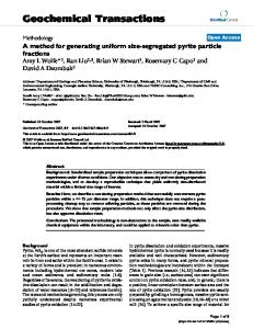
For example, the record of observations of the sands entering the channel from the Wulanbuhe and Hedong deserts is only two years and cannot provide definitive results for long-term desert sand input. Thus, the results obtained by these methods cannot provide useful information for the recurrence of the sources of sediment. Using the sediment budget method to analyze the contribution of different sediment sources to channel siltation of the Ningxia-Inner Mongolia reaches may lead to a large calculation error (Ta et al., 2008). Geochemical properties of sediments are retained during their erosion, transport, and deposition and, thus, can be used to infer their sources (Collins et al., 1998; Walling, 2005; Walling and Woodward, 1995; Walling et al., 1999). Jia et al. (2011) performed investigations for Ti and other six trace elements on the Ningxia-Inner Mongolia reaches of the Yellow River; however, multivariate statistical analyses were not performed and the relationships among these elements were not clear. As such, the best tracer could not be determined and the true source of the coarse sediments in these reaches could not be identified. Multivariate statistical analysis methods, such as factor analysis and correlation analysis, have been widely used for the interpretation of geochemical data on sediment (Shrestha and Kazama, 2007; Zhou et al., 2007; Yang et al., 2010; IJmker et al., 2012). These analysis methods can extract regularity from a variety of complex and messy data. For example, factor analysis pays attention mostly to investigating intergrowth association among variables and extracts useful information from mass data, and the relative importance among these variables can be evaluated. Our study is the first to use statistical analysis on the trace elements data of coarse sediment samples from the NingxiaInner Mongolia reaches and is important in view of the relationship between the various elements. Our specific objectives are (1) to reveal the relationship among the trace elements of the coarse sediments and (2) to affirm sources of the coarse sediments in the Ningxia-Inner Mongolia reaches of the Yellow River. 2. DESCRIPTION OF THE STUDY AREA With a total length of 1000 km (from Xiaheyan to Toudaoguai), the Ningxia-Inner Mongolia reaches flow through two plains (Yinchuan and Hetao) and three desert regions (Hedong, Wulanbuhe, and Kubuqi) (Fig. 1). This region is characterized by a dry climate. Western or northwestern dominant strong winds occur frequently with the sand dunes of the Wulanbuhe Desert sometimes extending 100 m into the river channel (Ta et al., 2008). This reach has a wandering and twisting channel with high lateral erosion, which leads to frequent riverbank collapses, especially in the Bayangaole to Sanhuhekou reach (Yao et al., 2011; Ta et al., 2013). The most famous tributaries in this reach are the Ten
Tributaries, which originate in the high platforms of the Ordos Plateau, across the Kubuqi Desert from south to north. In the windy season large quantities of sand from the Kubuqi Desert is carried into the valleys of the Ten Tributaries. In the rainy season, thunderstorms and floods frequently occur in this area, carry some of the material deposited in the valleys into the Yellow River. According to the distribution of major sources area, we divide the Ningxia-Inner Mongolia Reaches into three sections (Table 1). There are six hydrological gauging stations in the study reaches. It is apparent that the annual sediment transport and the annual discharge in this reach began to decline following the construction and operation of large reservoirs in the upper reaches of the Yellow River (Fig. 2). From Liujiaxia to Xiaheyan, the Yellow River runs through the influx region in the Loess Plateau (Huang et al., 1992), with several tributaries flowing into the river (Fig. 1). The Loess Plateau is characterized by a fragile structure, low resistance to erosion, and poor vegetation (Yang et al., 1986). Materials eroded from the plateau during the rainy season are carried by the Daxia, Tao, and Huangshui rivers entering the Yellow River (Zhao et al., 1999). Controlled by the topography and larger slopes of this reach, the river channels are relatively narrow, and there is little sediment deposited in the riverbed. In some sections of this reach, the riverbed materials are mainly composed of gravel and rock. 3. METHODOLOGY 3.1. Sampling and Laboratory Measurements During our fieldwork, we collected samples of riverbed sediment in the main reaches of the upper Yellow River and its main tributaries (Daxia, Tao, Huangshui rivers and the Ten Tributaries), desert sand samples from the Hedong and Wulanbuhe deserts, and samples of riverbank material (Fig. 1). The sampling locations were away from cities and towns to minimize the influence of industrial contributions. To obtain the riverbed sediment in the Gansu reach and the Ningxia-Inner Mongolia reaches of the Yellow River, we drilled 55 shallow sediment cores with 3 m long × 5 cm diameter iron pipes inside a plastic sleeve. We drove the cores vertically from a trestle using a hammer and were approximately 0.5–1.0 m deep in bars or floodplains. The riverbed sediment of the tributaries was mainly from the shallow layer of the riverbed (about 10 cm depth). We stored the sediments in plastic bags and brought the samples to the laboratory. In the laboratory, we transferred a portion of the sediments to glass beakers and used 10% H2O2 and 0.1 mol L–1 HCl to eliminate organic matter and some pollutants from the sediment. After washing, we dried all the samples at 100 °C for 24 h and sieved them to determine the coarse sediment particle size. On average, most
Sources and trace elements of the coarse sediment in the upper Yellow River
183
Fig. 1. Plan view of the Ningxia-Inner Mongolia reaches of the Yellow River and sampling locations. Table 1. River reaches and sediment sources of the Ningxia-Inner Mongolia reaches of the Yellow River Reach Gansu reach Hedong-Wulanbuhe desert reach Linhe reach Ten tributaries reach
Range Liujiaxia-Xiaheyan Qingtongxia-Bayangaole Bayangaole-Sanhuhekou Sanhuhekou-Toudaoguai
riverbed sediments along the Ningxia-Inner Mongolia reaches have median sizes larger than 0.08 mm (Ta et al., 2008). Therefore, our analysis in this study focused on the coarse sediment (particle size: 0.08–0.25 mm). We ground these coarse sediment samples to powder form (10 ppm) in the analysis. For all statistical analyses we used SPSS v. 18.0 for Windows. 4. RESULTS 4.1. Trace Element Contents of Coarse Sediments and Correlation Analysis Mean concentrations of 28 trace elements in the coarse sediment from the Gansu reach and Ningxia-Inner Mongo-
lia reaches of the Yellow River are shown in Table 2. Ti exhibited the highest concentration, followed by Mn, Ba, P, Sr, Ce, Co, and S. Rb, Zr, Cr, Cl, As, Cu, Ga, La, Nd, Pb, Ni, Y, Bi, Hf, Mo, Nb, Sc, U, V, and W were present in lower concentrations (