The International Archives of the Photogrammetry, Remote Sensing and Spatial Information Sciences, Volume XL-3/W3, 2015 ISPRS Geospatial Week 2015, 28 Sep – 03 Oct 2015, La Grande Motte, France
SPATIAL DATA UNCERTAINTY IN A WEBGIS TOOL SUPPORTING SEDIMENTS MANAGEMENT IN WALLONIA N. R. Stéphenne a *, B Beaumont a, M. Veschkens a, S. Palm b, C. Charlemagne c a
ISSeP, Institut Scientifique de Service Public, 200 rue du Chéra, 4000 Liège, Belgium - (n.stephenne, b.beaumont, m.veschkens)@issep.be b Geomatic Department, SPW, Service Public de Wallonie, Chaussée de Charleroi, 83b, 5000 Namur, Belgium
[email protected] c DGO3, SPW, Service Public de Wallonie, 15 av. Prince de Liège, 5100 Jambes, Belgium
[email protected]
KEY WORDS: WebGIS, River Sediments, Basin Management Plans, Environmental Communication, Geospatial Data, Uncertainty, Quality Assessment
ABSTRACT: This paper describes a WebGIS prototype developed for the Walloon administration to improve the communication and the management of sediments dredging actions carried out in rivers and lakes. In Wallonia, levelling dredged sediments on banks requires an official authorization from the administration. This request refers to geospatial datasets such as the official land use map, the cadastral map or the distance to potential pollution sources. Centralising geodatabases within a web interface facilitate the management of these authorizations for the managers and the central administration. The proposed system integrates various data from disparate sources. Some issues in map scale, spatial search quality and cartographic visualisation are discussed in this paper with the solutions provided. The prototype web application is currently discussed with some potential users in order to understand in which way this tool facilitate the communication, the management and the quality of the authorisation process. The structure of the paper states the why, what, who and how of this communication tool with a special focus on errors and uncertainties.
1. INTRODUCTION According to Europe’s first River Basin Management Plans (RBMPs), 56% of European rivers failed to achieve the good status targets of the Water Framework Directive WFD (Solheim et al. 2012). The RBPM is the model proposed by WFD to improve water quality at the EU level. In Central European countries such as Belgium, even more than 80% of rivers failed to achieve the WFD quality targets. Although the RBMP’s should reduce the stressors and improve water body status, their potential to address multiple stress situations is limited due to insufficient knowledge on combined effects, multi-stress, prioritization of measures, impact on ecology and implementation effects (Hering et al. 2015). Sediments dredging is an essential operation carried out by rivers’ managers which should be integrated in the overal RBPM. This paper describes a WebGIS prototype developed for the Walloon administration to improve the communication and the management of sediments dredging actions carried out in rivers and lakes in the frame of RBMPs. As in most European countries (Cutroneo et al. 2014), a large number of stakeholders are involved in the management of rivers and lakes in Wallonia. They are in charge of technical aspects (client and dredging operators, organisations involved in the treatment of waste…), management aspects (managers involved in WFD implementation at communal, provincial or regional level) or policy aspects (people responsible for policy compliance or legislation revision). These three kinds of stakeholders need different information and data to cover their duties but have to interact closely. Moreover, information has to
be shared between them to improve the management quality of dredging operations within the ecological system. The communication tool proposed to improve the interaction between these stakeholders in the context of sediments management is a WebGIS application. The use of internet is intuitive because it places data and forms at the disposition of those who need to use it. Because most of these data are spatial, Geographic Information Systems (GIS) allow combining them in a harmonized system. Using these two criteria, a WebGIS application integrates existing geodatabases, alphanumerical information and new information referring to the specific request of sediments management. As requested by the regional administration (SPW – Service Public de Wallonie), ISSeP develops a prototype of this tool under the supervision of a scientific committee. This paper details the structure of this WebGIS application in two chapters. The first chapter presents the area proposed by the scientific committee and the data needed to compile the request according to the legislation. The second chapter refers to the methodology chosen for this application and to the audience targeted by the tool, knowing that its objective is improving the communication between the various stakeholders. The web interface is a mean to increase the quality of the communication, decrease the errors in spatial analysis, data integration, choice of data input and interpretation. Both chapter address spatial issues arisen in developing this tool.
* Corresponding author
This contribution has been peer-reviewed. Editors: C. Mallet, N. Paparoditis, and I. Dowman doi:10.5194/isprsarchives-XL-3-W3-625-2015
625
The International Archives of the Photogrammetry, Remote Sensing and Spatial Information Sciences, Volume XL-3/W3, 2015 ISPRS Geospatial Week 2015, 28 Sep – 03 Oct 2015, La Grande Motte, France
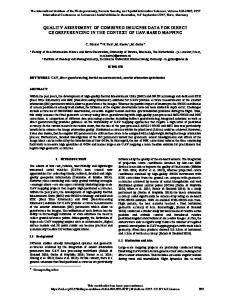
2. STUDY AREA AND DATA 2.1 Walloon region and legislation Wallonia is the southern part of Belgium with a regional administration in charge of implementing EU directive and regional decrees. In the frame of soil, water, wastes and sediments management, rules and laws are sometimes complex to be practically applied by all management levels. In the particular case of sediment management, the administration distinguishes the navigable and unnavigable waterways. Two distinct services are in charge of the management of these mingled networks. Moreover, unnavigable rivers management is shared between four levels in SPW: regional, provincial, communal and private (citizens are responsible for the dredging of local ponds or small rivers). The size of the watershed (< 100 ha or > 5000 ha) and the borders of the communes defines the limits between these four levels of power (See Figure 1).
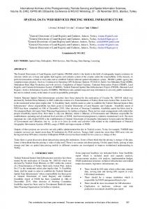
To better understand the goal of this application, the potential users’ tasks and knowledge, and the functionalities expected, a prototype has been developed and presented to the scientific committee. This prototype covers two watersheds: Sambre and Mehaigne.
Figure 2. Area of Interest & WebGIS interface prototype 2.3 Geospatial data
Figure 1. Management levels for unnavigable rivers Recently, the Walloon waste decree defined as “waste”, the material or sediments extracted from the rivers. In small unnavigable rivers, management practice often pull sediment material out of the water to spread it along the rivers’ banks. According to the soil decree, recently approved, the pollution of these sediments should be assessed before levelling. This practice could then only be authorised in specific conditions and decided by the central administration. The application of this decree requires an update of the current legislation on river sediments. This update is currently under discussion with the Walloon government. Putting in place this decree is then a difficult and long process because it requires a drastic change in the current way of working of a lot of stakeholders with an administration burden for which most of them are reluctant. 2.2 Area of interest and prototype In order to facilitate the necessary changes in sediments management, the SPW requested a tool which should increase the easiness, the quality, and the rapidity of the communication between the stakeholders. ISSeP proposed a WebGIS interface. This tool has different objectives: to harmonise data sources and spatial analysis, to facilitate the transfer of information between the local manager and the central authority, to standardize the dredging operations, to support the managers and the administration in filling out the forms for the authorization, to keep track of these operations in a central data base and finally, to develop adding-values sediments operations.
According to the current version of the new text proposed to the government, the “map of sediments management” is defined at the scale of the watershed and provides direct and indirect geospatial data referring to rivers, lakes, sediments, soils of water banks, discharges, pollution results of sediments samples analysis, records of dredging operations, land cover of banks, distance to urban areas, cadastral map, official planned use of the soil … Data sources
format
Hydro Network (DGO3© SPW) Discharges (DGO3© SPW) Ponds/lakes (DGO3© SPW) Quality samples (© ISSeP) Storm basins (DGO1© SPW) Sewer plans (©SPGE) Land use map (DGO4© SPW) Cadastral map (© SPF) Topographical maps ((© IGN) Orthos and admin. Maps (© SPW) Natura (DGO3© SPW)
lines points poly points poly geoserv geoserv geoserv geoserv geoserv geoserv
Table 3. Types of geodata integrated in the WebGIS These data are collected by several services of the SPW. Unfortunately, these dataset have been created according to different methodologies with their own specifications in terms of scale, quality, resolution … For example, the official land use map available on the following web site http://webgisdgo4.spw.wallonie.be/viewer has been originally manually digitalised on 1/10 000 IGN (National Geographical Institute) maps between 1977 and 1987 and scanned to produce a digital version (DGATLP, 2007). According to this document, the actual precision is below 1/25 000 (1mm = 25m). There are several quality shortcomings related to the drawing scale, the legend definition, the quality of reference map, the digitalisation method, bad position of this original reference map, scale and low precision. On the interface, the visualisation is limited to the 1/10 000 scale. On the contrary, the high resolution map which is proposed as the official georeference for the Walloon region is
This contribution has been peer-reviewed. Editors: C. Mallet, N. Paparoditis, and I. Dowman doi:10.5194/isprsarchives-XL-3-W3-625-2015
626
The International Archives of the Photogrammetry, Remote Sensing and Spatial Information Sciences, Volume XL-3/W3, 2015 ISPRS Geospatial Week 2015, 28 Sep – 03 Oct 2015, La Grande Motte, France
called PICC (Projet Informatique de Cartographie Continue in French). This map has been created since 1991 and completed this year with a resolution of 25cm (PICC, 2015). 2.4 Alphanumerical data Within the authorisation for operations, administrative and qualitative information are requested from the sediments managers. Besides the personal information about the responsible, his role, functions and juridical position, the address of the office and contacts number, some information about the timing and the type of operations planned are integrated in a standard form that is under discussion with the administration.
3. METHODS AND UNCERTAINTIES 3.1 Walloon context in geographical data Since recently, in line with Inspire directive, the geomatic department of SPW develops a Walloon geoportal to disseminate regional geospatial data to the public: http://geoportail.wallonie.be/. This website provides general information about the actions and plans of the administration in the context of geodata. The geocatalog organize the metadata information. On the geospatial application called “WalOnMap”, the user has a direct access to existing web applications and available dataset in the format of “geoservices”. As stated in the geoportal, these geographic web services, or geoservices, are computer communication protocols that enable a server to communicate with a client application. There are several kinds of geoservices to be used within geographical applications or software via the network: map services to visualise the data (WMS – web map service), feature services to edit the lines, points or polygons (WFS), coverage services for continuous raster images such as digital elevation models or orthophotographs (WCS) … The Walloon geoportal uses an API protocol based on API JavaScript Dojo with functionalities from the API JavaScript from ESRI. This protocol is called API geoviewer (http://geoservices.wallonie.be/geoviewer/documentation/). As the SPW proposes this protocol and offers a support in the configuration of the tool for specific applications, the prototype map of sediment management has been developed with this protocol. As more and more administrations and Walloon users know the geographical interface, this choice will facilitate the communication among stakeholders. 3.2 API geoviewer configuration The prototype map of sediments management displays specific geodata related to their management (see 2.3 & Figure 2) The geoservices provided by WalOnMap and relevant for this application are integrated in the catalog. While the geoportal WalOnMap integrates mainly WMS and WCS geoservices, the sediments application aims to create a geodatabase of all ongoing or past dredging operations. In that aspect, the various stakeholders should be able to edit the information to reference their operations. The main functionality that is needed in this application is the edition of the operation layer.
The alphanumerical information related to this operation are stored in a form related to the geodatabase. The stakeholder can answer the various questions and refer all the time to the map to check the source of information. This report to be validated by the administration should also be kept in PDF or paper by the manager for his administration. An automatic report can be printed or saved digitally whenever the manager needs it or quits the application. Only the specific users should have access to this web application. A security module with login and password restricts the audience. Moreover, according to the role of the user, either manager of operation or administrator of the authorization, the application provides pertinent functionalities. For example, when the form of request for authorization is filled by the manager, an email is automatically sent to the administrator. When the last has given his advice, another email informs the manager. 3.3 Communication flow One of the main aims of this WebGIS interface is a fluid and efficient communication between the stakeholders involved in the dredging (technical communication).WebGIS streamlines the monitoring process as data input, integration of data from different sources, map representation and database queries (Cutroneo et al. 2014). This tool accessible anytime and anywhere offers a decision support system to the SPW. Inspired by Cutroneo et al. (2014), we examined the Walloon stakeholders under the why, who, how, what are the best method and what are the errors. 3.3.1 Why to improve the communication flow on sediments management with a WebGIS? The objectives are already listed in 2.2. but the geospatial aspects of these reasons refer to : (i) the use of the same, accurate and up to date spatial information required by the administration and (ii) the centralisation and validation of all information in a geodatabase accessible to all stakeholders with different roles. 3.3.2 Who are the stakeholders? The introduction states the technical, managerial and political actors in the Walloon context of sediments management. The 2.1 section describes the administrative services which are in charge of their respective parts of the river network: DGO2 for Navigable river, DGO3 for unnavigable. There are regional, provincial, communal and private responsible. The two roles defined in the application distinguish these various managers from the central administrator which validate or not the authorisation. 3.3.3 How do we communicate efficiently? While the current transfer of information is done on papers without instructions on the references data sources, the WebGIS interface provides a standardized form which has to be filled out with the spatial information available on the geoservices. These services will be updated regularly when necessary by the data providers. The use of internet should increase the easiness of reaching all managers. However, perhaps some of them do not have access to internet. Hoping that the number of these users is decreasing all the time, the form to be provided to the administration is also provided in a paper format. 3.3.4 What are the spatial issues in a WebGIS application? Firstly, spatial dataset are evolving in time according to the needs and technological levels. In the specific context, existing
This contribution has been peer-reviewed. Editors: C. Mallet, N. Paparoditis, and I. Dowman doi:10.5194/isprsarchives-XL-3-W3-625-2015
627
The International Archives of the Photogrammetry, Remote Sensing and Spatial Information Sciences, Volume XL-3/W3, 2015 ISPRS Geospatial Week 2015, 28 Sep – 03 Oct 2015, La Grande Motte, France
dataset are currently revised to increase their spatial resolution. In particular, the hydrological network was manually digitalised on old IGN maps without homogenous standards. Aware of these shortcomings, the responsible requested a methodology to geolocalise the old network on the new Walloon georeference, combining the PICC and the orthophotographs. This new dataset is not legally binding for the river managers and the validation is ongoing but this new dataset gives a precise position of the river. The rivers can be overlaid to the orthophotographs and other maps to cross the spatial information. The second issue is the scale of the dataset which differ from one set to the other. Some, as discussed for the land use map, do not have the spatial resolution needed for the sediment management map. A 1/10 000 map is required to draw the picture of the area of interest, but the authorisation should be defined at a scale of 1:2500. Only paper maps of land use are publicly available at this scale .A specific request and protocol of use of this map should be created by the administration to include high precision land use in the WebGIS. The third issue refer to the legal value of digital information. Walloon decree does not refer to WebGIS application, the authorisation should always be provided on paper. Even if this tool can produce a PDF report of the form with maps included, the official document will remain the paper. The easiness of completing the form and having access to the data competes with the legal aspect.
4. CONCLUSION Combining an intuitive use of internet and GIS functions to integrate geospatial data in a harmonized system, the “map of sediments management” should improve the communication between various actors in Wallonia. The WebGIS technology has numerous advantages in terms of data harmonisation, transfer of information, standardization of spatial analysis and support to administration operations. Thanks to the prototype, the discussion with the scientific committee addressed the spatial and alphanumerical data needs, the configuration of the API protocol and the specific functionalities required in that application such as the security module or the edition of the central database. Even in this preparatory phase, the use of an interface helped to identify the issues in the communication flow. In the operational phase, this tool aims to create a fluid and efficient communication between stakeholders through a common access to up-to-date data.
ACKNOWLEDGEMENTS We acknowledge the support of Michael Hansroul and Ludovic dela Corte from ESRI BeLux in the technical development of this prototype. REFERENCES DGATLP, 2007, Le plan de secteur : Note d’accompagnement à la diffusion de la cartographie, last access on 04/ 2015 http://dgo4.spw.wallonie.be/DGATLP/DGATLP/Pages/DAU/D wnld/PDS/Note_Diffusion.pdf Cutroneo, L., Massa, F., Castellano, M., Canepa, G., Costa, S., Povero, P., Tucci, S. & Capello, M., 2014. Technical and public approaches to involve dredging stakeholders and citizens in the development of a port area. Environ Earth Sci (2014) 72:3159-3171. Hering, D., Carvalho, L., Argillier, C., Beklioglu, M., Borja, A., Cardoso, A-C., Duel, H., Ferreira, T., Globevnik, L., Hanganu, J., Hellsten, S., Jeppesen, E., Kodes, V., Solheim, A-L., Noges, T., Ormerod, S., Panagopoulos, Y., Schmutz, S., Venohr, M. & Birk, S., 2015. Managing aquatic ecosystems and water resources under multiple stress – An introduction to the MARS project. Science of the Total Environment 503-504 (2015) 1021. PICC, 2015. Projet Informatique de Cartographie Continue. Direction de la Géométrologie (SPW - SG - DGEO). Région Updated 01/ 2015 wallonne. http://geoportail.wallonie.be/geocatalogue?activeMDTypeTab= mdType_application&search-theme=theme_50&searchsubtheme=all&search-text=PICC&searchtri=jcr%3Atitle&search-display=small#. Solheim, A-L., Austnes, K., Kristensen, P., Peterlin, M., Kodes, V., Collins, R., Semeradova, S., Kunitzer, A., Filippi, R., Prchalova, H., Spiteri, C. & Prins, T., 2012. Ecological and chemical status and pressures in European waters. Thematic assessment for EEA Water 2012 Report. ETC/ICM Technical Report 1/2012. EEA/NSV/10/002. Pp 1-44.
However, we should be aware that if GIS allow combining several data source, the propagation of errors should be taken into account. Three specific issues have been discussed: (i) the precision of legal datasets, (ii) the scale of the dataset in comparison to the needs of the administration, (iii) the legal value of digital information while the access to internet is not mandatory in the administration. Several control systems to validate the edition by the operators will be proposed and put in place in the operational phase.
This contribution has been peer-reviewed. Editors: C. Mallet, N. Paparoditis, and I. Dowman doi:10.5194/isprsarchives-XL-3-W3-625-2015
628