Spatial Exploration Patterns and Efficiency 1 Running head: SPATIAL EXPLORATION PATTERNS AND EFFICIENCY
Spatial Exploration Patterns Determine Navigation Efficiency: Trade-off Between Memory Demands and Distance Travelled
Tamas Makany, Edward S. Redhead, & Itiel E. Dror
School of Psychology, University of Southampton Southampton, SO17 1BJ, United Kingdom Telephone: +44 23 8059 6698 Email of correspondence:
[email protected]
Spatial Exploration Patterns and Efficiency 2 Abstract Forty-one participants explored a novel square-shaped environment containing five identical boxes each hiding a visually distinct object. After an initial free exploration the participants were required to locate the objects first in a predetermined and subsequently in an optional order task. Two distinct exploration strategies emerged: participants explored either along the main axes of the room (Axial), or in a more spatially spread, circular pattern around the edges of the room (Circular). These initial exploration strategies influenced the optimality of spatial navigation performance in the subsequent optional order task. The results reflect a trade-off between memory demands and distance efficiency. The more sequential Axial strategy resulted in less demands on spatial memory but required more distance to be travelled. The Circular strategy was more demanding on memory but required less subsequent travelling distance. The findings are discussed in terms of spatial knowledge acquisition and optimality of strategy representations.
Spatial Exploration Patterns and Efficiency 3 Strategies reflect both structural commonalities and programmatic patterns in cognitive processes (Gordon, 2004). The value of a strategy reflects an optimized trade-off between the costs and benefits of the utilized behaviour. In the case of spatial navigation, a strategy refers to a mental representation of the navigator’s own position in relation to the surrounding spatial environment including a goal position and an intentional plan to reach that goal in an optimal way. In previous studies of spatial search and navigation, the time in which a task is solved was taken as a rough indicator of underlying spatial ability – such as learning (e.g., Morris, 1981) or mental manipulations (e.g., Shepard & Cooper, 1982). Decreasing escape latencies in a water maze study, for example, would suggest that the animals are learning the spatial layout of the pool. However, it does not reveal much about the nature of learning, whether it was a qualitative or quantitative change (Thinus-Blanc & Gaunet, 1997). To analyse patterns of behaviour in spatial navigation further measures are required over the commonly applied method of latency. Visible indices of navigation – like path choices or object visit sequences – are also measured with video recordings and independent observation tools with defined sets of coding guidelines (Graziano, Petrosini, & Bartoletti, 2003; Makany & Kallai, 2004). Alternatively, automated algorithms can identify behavioural patterns within large datasets of spatial information, such as video surveillance of pedestrian movements (Helbing, Keltsch, & Molnar, 1997; Sas, O’Hare, & Reilly, 2003). In fact, pattern formation of any complex spatial system can be described by the inherent syntax that determines their physical appearance (Hillier, 1996). Exploratory patterns are the behavioural manifestations of spatial strategies, and the frequency of reoccurrence is a quantitative indicator of how well that spatial knowledge is being utilized.
Spatial Exploration Patterns and Efficiency 4 An earlier study of navigation behaviour found that global patterns change over time as a result of spatial learning (Tellevik, 1992). Three patterns were observed while blindfolded participants searched for target objects inside a room. Two of them (perimeter and gridline) were determined by the size and the shape of the environment. In the perimeter case, the participants limited exploration to the border of the environment, while the gridline referred to a strategy where participants followed straight line from one side of the environment to the other. The third type of pattern was referred to as the reference-point strategy, where an object served as a point for each significant directional change. Tellevik argued that familiarity with the space allowed the participants to utilize object-to-object relationships rather than being preoccupied with the spatial characteristics of the environment (i.e. shape). Object based searching led to a better performance with a wider array of specific strategy patterns. In a study by Kallai, Makany, Karadi, and Jacobs (2005) reoccurring patterns of exploration behaviour were found to be good predictors of navigation performance and also as indicators for the temporal dynamics of spatial knowledge acquisition. Some patterns appeared more often during the early phases of spatial learning, such as the wall-following strategy, while others (e.g., visual scanning strategy) became more apparent, when a reliable representation of the space was formed. The authors concluded that human participants with poorer spatial abilities needed to periodically re-stabilize their positions in relation to the fixed perimeter, therefore they used the wall-following strategy more extensively. Whereas advanced navigators could benefit from linking the allocentric external landmarks to each other, which allowed them to reduce their walking distances and to switch to a more memory dependent strategy. Thinus-Blanc and Gaunet (1997) suggested that changes in exploratory patterns correspond to a multi-level acquisition and representation of spatial knowledge . A cyclic
Spatial Exploration Patterns and Efficiency 5 strategy enables a rough comprehension of the spatial relations, while back-and-forth movements refine the spatial knowledge, allowing a detailed and well-organized encoding. Consequently, the latter strategy leads to more efficient performance. It should be noted however, that the reported optimal cyclic strategy in baboons by Gouteux, Vauclair, and Thinus-Blanc (1999) was, in fact, found to be non-optimal in the human data (Gaunet & Thinus-Blanc, 1996). This suggests that while animals utilize a more sequential exploratory strategy as their optimal foraging behaviour, humans achieve better scores if they were more concerned with constructing a detailed representation of the space. One interpretation of the discrepancy between the two sets of results could be that a compromising mechanism sets the balance between cognitive load and travelled distance costs, in a sense that humans utilize their cognitive abilities better in spatial navigation tasks (Thinus-Blanc & Gaunet, 1997). Despite the growing interest in recognising patterns of navigation, there is little understanding on how spatial knowledge acquisition and representation correspond to observable exploratory behaviour. Although a number of studies focusing on the representation of spatial cues, such as landmarks or environmental geometry (e.g., Cheng & Newcombe, 2005), and on identifiable patterns during navigation (e.g., Thinus-Blanc & Gaunet, 1997) have been performed, investigations are needed to understand the relation between these two levels of spatial cognition. Cognitive modelling of strategy representations offers a domain-independent analysis, which could be effectively utilised in any domain-specific system, such as the spatial domain (Gordon, 2004). A spatial strategy should simultaneously reflect the structural pattern of navigational behaviour and an intentional act of a cognitive plan. These patterns should be observable and meaningful in their functions. The focus of the present study is to connect
Spatial Exploration Patterns and Efficiency 6 behavioural performance with certain patterns of exploratory activity, and to provide plausible interpretations to how strategies manifest on each level of spatial navigation. In this paper, we analysed initial exploratory patterns of human spatial navigation and related them to navigation patterns in a subsequent search task. Our first question was whether there are distinct patterns in initial exploration of a novel environment. We implemented an automated clustering algorithm in order to investigate emerging structural regularities within the routes of spatial exploration. The visual characteristics of these patterns would reflect on the preferred exploratory strategy. We further examined whether any pattern type during initial exploration would determine performance in subsequent structured navigation. A more intensive and spatially extensive search strategy would result in a better representation of the space, hence better performance scores in specific navigation tasks. However, human navigation performance and efficiency cannot be unequivocally determined by means of heuristic algorithms (see Mitchell, 2004 for a computational explanation of these algorithms), thus the measurements are dependent on how optimal performance is defined (MacGregor & Ormerod, 1996). Due to the complex nature of navigation behaviour, we measured performance in two different ways: one examined the size of the search space (Binary measure) and the other focused on the total travelled distance (Frequency measure). Conclusions about the human cognitive and energy cost-and-benefit optimization in spatial navigation tasks were drawn from the findings.
Method Participants Forty-one university students participated in the study. They were 17 males and 24 females, who ranged in age from 18 to 50 (mean age = 29.81; SD = 9.23). Participants received either course credits or payment.
Spatial Exploration Patterns and Efficiency 7
Apparatus The experiment was conducted in a square room (L 3.5 m x W 3.5 m x H 2.5 m) with walls covered by black curtains that masked all spatial information outside the room. The room was evenly illuminated from the four corners by neon lights set in the ceiling. A speaker was hidden behind the curtains to communicate the tasks to the participants. A video camcorder was placed in the centre of the ceiling, to record the navigation activity from a bird’s eye-view perspective. The room contained five visually identical open cardboard boxes placed in an irregular array on the floor. The dimension of the boxes was L 55 x W 55 x H 150 cm. A different object was placed inside each box. The five objects were similar sized coloured toys: a gorilla, a yellow bird, a ball, a frog and a puffin. An object could only be seen by leaning over the top of the box. This ensured that participants had to walk close to the box to explore its content.
Procedure The participants were led by the experimenter to a starting position in the room with their eyes closed. The starting position was a fixed location in the closest corner to the entrance door throughout the whole experiment. On a spoken signal from the experimenter who had returned to the adjacent control room, the participants opened their eyes to begin their exploration. The camera on the ceiling recorded all navigation activity. There were three phases in the experiment. Phase 1: For 1 minute, the participants were asked to freely explore the novel environment. Participants were instructed to walk around the room and familiarize themselves with the location of the five objects inside each box. Phase 2: participants were instructed to perform simple navigation tasks, whereby they were
Spatial Exploration Patterns and Efficiency 8 required to visit the objects in a predefined order. They first visited each object one-by-one (single) and then they had to link two or three (multiple) objects by visiting them in a fixed order. The required sequence of visits was the same for all participants. Participants carried out 5 single object and 6 multiple object visits. The purpose of this phase was to ensure that all participants have learnt the spatial layout of the room and the location of the objects. All participants finished at the position from where they had begun in Phase 1. Phase 3: Participants were asked to visit 3 objects in any order they wished. This task was repeated 3 times (3 x 3 visits) with different combination of objects on each trial. All participants were given the same combinations whereupon they could choose their preferred order of visit. Throughout the experiment, the participants were asked to find the objects as quickly and efficiently as possible, however there was no specific time limit on Phase 2 and Phase 3. After the last task was completed, the experimenter entered the room and lead the participant out. Results Transcribing data First, the navigation activity, recorded on videotape, was transcribed to a quantifiable format. The transcription implemented a 6x6 grid matrix, which represented the squared room from the perspective of the camera and the spatial positions of the participant was coded within this grid. With such partition of the room, each of the five identical boxes occupied one square of the grid, leaving 31 positions free for navigation. The coding required that a participant could only occupy one square at a time, but stepping from one square to another could have happened in either horizontally, vertically, or diagonally in any directions, within the limits of this 6x6 structure.
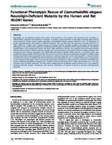
Spatial Exploration Patterns and Efficiency 9 At the start, all 31 possible navigation positions were set to 0, and as the navigator entered a square, that value changed to either 1 (Binary measure: number of squares visited), or increased by 1 (Frequency measure: total number of visits). This numerical matrix representation of the space allowed us to monitor the dynamics of the utilized spatial areas during both exploration and navigation (Phase 1 & 3, respectively). Determining Exploratory Patterns: Hierarchical Cluster Analysis Initial exploration patterns were grouped with a hierarchical cluster analysis. The clustering method was the complete linkage (furthest neighbour) with squared Euclidean distances. All the computations were carried out with the statistical software package SPSS 14.0 (SPSS Inc., 2005) A good clustering solution was deemed to have small within-cluster distances, and large between-cluster distances (Everitt, Landau, & Leese, 2001). An inconsistently large jump within the similarity measure between joined clusters indicated a good termination point for the clustering procedure (Clatworthy, Buick, Hankins, Weinman, & Horne, 2005). In this study a rescaled distance cluster value of 20 was used to determine the termination of cluster splitting. With this criterion two clusters of recurring patterns were found, Axial and Circular labelled according to their visual appearance. There were 11 participants in the prior and 28 in the latter group. One participant’s (number 22) pattern did not belong to either of these clusters, and was excluded from further analysis. In the case of another participant (number 8), there was a videotape error resulting in this data also being omitted. Determining Spatial Efficiency Two measures of spatial efficiency were adopted in the present study. Binary efficiency measure focused on the spatial expansion of the exploration activity. This involved counting the number of squares, in which the participant entered at least once during the navigation test, without considering how many times that position was visited in total. A Binary score
Spatial Exploration Patterns and Efficiency 10 represented the sum of squares with a maximum possible of 31 (all 36 squares minus the 5 squares with an object on them). The most spatially efficient score could be associated with the smallest size of the actively used space, whereat the task was still solvable. Another way to measure efficiency is counting the actual frequencies of all the square visits within the grid (Frequency measure). Practically, this measure expressed the total travel distance in addition to its spatial distribution on the matrix. The sum could have infinitely increased, however the most efficient strategy reduced both the number of visited squares and the frequency to the possible minimum.
Figure 1 about here
Differences in Spatial Efficiency Based on the Exploratory Patterns In the case of the Binary efficiency measure, where the matrix contained only 1 or 0, the independent groups two-tailed t-test revealed a significant difference between the mean spatial efficiency scores of the two pattern clusters [t (37) = 8.03, p