Geographical & Environmental Modelling, Vol. 6, No. 1, 2002, 41±57
Spatial Structures and Scale in Categorical Maps JONATHAN D. PHILLIPS Abstract Spatial variability is typically represented by categorical maps or by samples taken at speciWc locations (point data). The regions or patches represented in categorical maps are intuitive and consistent with much geographical (and ecological, pedological, etc.) theory, but point data are more amenable to geostatistics and other approache s which allow examination of scales of variability and of spatial structure. The state probability function (SPF) is introduced as a tool for evaluating the spatial structure of landscapes represented as categorical maps. The SPF is based on the degree of similarity between mapped units or classiWcatory categories a given distance apart. A plot of the SPF vs. distance produces a graph which can be interpreted similarly to a variogram. The method is tested/illustrated using detailed soil map data from eastern North Carolina. The SPF is shown to be appropriatel y sensitive to major landscape boundarie s across which the suite of soil types changes, and to the degree of clustering of similar units.
Introduction Several research traditions in physical geography are based on the premise that there are strong links between landscape patterns and landscape processes, function, and evolution. This is particularly explicit in landscape ecology (e.g. Forman, 1995; Gustafson, 1998; Kupfer, 1995) and in soil geography (Fridland, 1976; Hole & Campbell, 1985; IbaÂnÄez et al., 1995). In both sub®elds a number of methods have been developed to quantify and characterize spatial patterns, with the ultimate goal of identifying and elucidating landscape processes. The pattern±process link is perhaps less explicit in other sub®elds of physical geography, but seems clearly related to the form±process connections often addressed in geomorphology. Walsh et al. (1998) suggested that a more explicit application of the `pattern±process±scale paradigm’ of landscape ecology to geomorpholog y would be fruitful. Spatial patterns are generally represented either as categorical maps or as spatial point samples. Maps oVer many advantages, but point data allow the use of spatial statistical tools to address important questions such as appropriat e scales of analysis, and the quanti®cation of spatial structure. The purpose of this paper is to introduce a method for identifying scales of variability and quantifying spatial structure of categorical maps, in a manner analogous to that of the geostatistical variogram. Jonathan D. Phillips, Tobacco Road Research Team, Department of Geography, University of Kentucky, Lexington, KY 40506, USA. E-mail:
[email protected] u 1361-593 9 print/1469-832 3 online/02/010041-1 7 DOI: 10.1080 /1361593022012728 8
© 2002 Taylor & Francis Ltd
42
Jonatha n D. Phillips
The quantitative tools for evaluating spatial patterns of landscapes may be grouped into two general types, associated with categorical maps and point data. Indices essentially generate a single number to characterize some aspect of the spatial pattern of a categorical map. Examples include entropy statistics and indices of fragmentatio n and contagion. The second type involves functions, which generally involve the depiction (commonly by a plot or graph) of some measure of spatial variability over size, scale, or distance. Examples include autocorrelation , spectral, and semivariance functions. Reviews are given by several authors (Gustafson, 1998; Haines-Young & Chopping, 1996; IbaÂnÄez et al., 1995; McBratney, 1998). There are examples of hybrids or combinations of the two, as when indices of spatial structure are derived from functions, or when indices are calculated at diVerent resolutions to produce a function. However, Gustafson’s (1998) review of the state of the art in quantifying spatial pattern identi®ed a clear gap between the type of information generated by categorical maps and the tools available for characterizing their spatial patterns, and geostatistical functions for quantifying the spatial structure of point data. There is therefore a need for a spatial function applicable to categorical data. More explicitly, the idea is to develop a method whereby a graph comparabl e to, and interpreted in the same way as, a variogram may be constructed for categorical maps and data. The variogram or semivariogram is a common tool for use with quantitative data in geostatistics and spatial statistics (McBratney, 1998; Oliver et al., 1989). Spatial Functions for Categorical Maps Variograms and related geostatistical functions require interval or ratio-level quantitative data. It is therefore diYcult to apply these methods to categorical maps. In some cases this can be overcome by deriving quantitative measures. For example, soil or community types on a soil or vegetation map might be assigned quantitative values for particular parameters via lookup tables. Alternatively, a cartometric approach might be usedÐfor example, at sample points on the map the distance to the nearest soil or vegetation boundary could be measured. Another approach is that of Bregt et al. (1992), who devised the state probability diVerence function (spdf ), described in more detail below. The spdf is based on categorical data and produces a plot which can elucidate the structure of spatial variability. The weaknesses of the spdf are that it does not account for varying degrees of similarity among categorical units, and does not produce a graphic resembling a variogram. A more familiar approach is the adaptation of geostatistics to categorical attributes. This is described brie¯y here to provide a frame of reference before presenting the state probability function. Goovaerts (1999) discusses categorical applications of geostatistics in the context of examining the spatial variability of measured soil parameters grouped into several categoriesÐfor example, pH values grouped into reaction classes, or contamination levels classi®ed according to risk or toxicity thresholds. Let a quantitative, point-measured variable x be grouped into a categorical attribute S with k possible states Sk , k 5 1, 2, . . . , k and ua denote a unique location. Then the function i(ua ;zk) 5 1
if z(ka) 5 sk
and i(ua ;zk) 5 0
otherwise
where zk is the value or state of the categorical variable.
Spatial Structures and Scale
43
Goovaerts (1999, p. 56) then presents a version of the semivariance function: N(h)
cÃ(h;zk) 5 1/[2N(h)] + [i(ua;sk) 2 i(ua + h;sk)] 2 a= 1
(1)
where N(h) is the number of points h units apart. Semivarianc e is plotted against the spatial lag distance h to produce what Goovaerts (1999) calls an indicator variogram, which is the basis for indicator kriging. There is no reason equation (1) could not be applied to data which are categorical to begin with. Like the spdf, the categorical semivariance function does not recognize varying degrees of similarityÐtwo locations are either identical (1) or diVerent (0). Also like the spdf, but unlike the regular variogram, theoretical limits for the indicator variogram are easily established: 1/[2N(h)] where all points are the same, 0.5 where no two points are the same, and (1/k) 2 /2 for a random sequence where any of the k states is equally likely at any location. The goal here is to produce a function which recognizes varying degrees of similarity in categorical data, which produces a visual tool comparable to the variogram, and which can be interpreted on an intuitively appealing 0 to 1 scale. The state probability function described below is applied here as a new and separate method, but can readily be generalized into modi®cations of indicator geostatisics or the spdf that account for varying degrees of diVerence between categorical variables. The State Probability Function The state probability function (SPF) is designed to determine how the spatial structure and variability of a categorical phenomenon is related to spatial scale or distance. The SPF is intended to produce information broadly similar to that of equation (1), with two major exceptions. The ®rst is that degrees of diVerence between map categories can vary according to degrees of diVerence rather than in a binary (same or diVerent) fashion. Second, the SPF is scaled to an intuitively appealing 0 (no diVerence) to 1 (maximum diVerence) scale. Let a landscape or spatial pattern take one of q distinct states Sk , k 5 1, 2, 3, . . . , q. These states could be, for instance, soil mapping units, morphostratigraphi c units, or vegetation community types. Associated with each k is some indicator of similarity assigned to each map category. These are arranged such that the states are increasingly dissimilar from 1 to q. Thus there is a similarity gradient, so that the similarity of system states Si and Sj is given by the absolute value of (Si 2 Sj ). If Si 2 Sj 5 0 the system states are identical. The maximum degree of dissimilarity would be associated with ½ Si 2 Sj ½ 5 Sq 2 S 1 . In this study the states are soil types. Other examples might include successional stages, or ecosystem or community types as they occur along gradients of climate or disturbance. Early successional states, for instance, would be more similar to each other than to late successional states. Or, for soils or landforms in a catenary sequence, those units in comparabl e catenary positions would be more similar than those at diVerent points on a catena. For example, suppose we are analyzing a map of vegetation communities that includes categories of salt marsh, brackish marsh, freshwater marsh, freshwater swamp, moist oak ¯ats, and mesic upland forests. Comparing two points that are both oak ¯ats would yield a value of zero. Comparing
44
Jonatha n D. Phillips
salt marsh with mesic forests would constitute the maximum degree of diVerence. The comparison of, say, freshwater marsh and swamp would yield a positive value less than the maximum. These varying degrees of similarity are re¯ected in the similarity indicators, which may be based on the arrangement of the states or categories along some gradient, a ranking, or a quantitative index assigned to each state. A state dissimilarity index (A ) for any two locations or map units Si , Sj is de®ned by A 5 ½ Si 2 Sj ½ / (Sq 2 S 1 ).
(2)
This index would be zero where the states are identical, and A 5 1 where there is the maximum possible degree of dissimilarity. The similarity index is therefore context sensitive. A state probability function can be computed, which represents the probability that the same system state will be found at some speci®ed separation distance:
( )/ n -h
SPF h 5 + A h
(n 2 h)
(3)
where h is the lag or separation distance. For a spatial transect with samples at 10 m intervals, for instance, SPFh for h 5 3 would be based on all pairs of sites 30 m apart. The emphasis here is on spatial structure, but the SPF could also be applied to temporal sequences, such as identi®ed states or stages in an historical timeline, or horizons, facies, etc. in a dated stratigraphi c sequence. The application of the SPF to a vertical feature such as a soil or weathering pro®le or sedimentary sequence might be useful in determining the extent to which the sequence may be timetransgressive. This type of application will be illustrated later. Plotting SPFh against h allows the structure of spatial variation in system states to be assessed. This state probability plot is broadly analogous to a variogram, particularly the indicator variogram associated with indicator kriging. One important diVerence between the SPF and traditional indicator geostatistics is that the variogram is derived from quantitative measurements (interval or ratio data), while the SPF is based on a qualitative categorization of system state (ordinal data). Another is that the SPF must range from 0 to 1, while the upper limit to the indicator variogram is 0.5. Some simple modi®cations to indicator kriging designed for use with categorical data would give information similar to that of the SPF function. In a random sequence, where all states are equally likely at all locations, the SPF would be the same at all lags:
{ f( q
SPF random 5 + i=1
q
+ ½ Si 2 S j ½
j=1
)/ g}/ q
(q 2 1).
(4)
Lower SPF values indicate a higher degree of system state similarity. This could be interpreted as spatial clustering or persistence. Low SPF values would re¯ect not only large contiguous areas of the same type, but also gradual transitions between similar types. Higher SPF values signify a lower degree of similarity. This suggests more fragmentatio n or smaller areas of categorical units, and more abrupt transitions between dissimilar states. Quantitatively, persistence and clustering is indicated where
Spatial Structures and Scale
45
SPF < SPF random. Where the SPF exceeds the random value, this suggests a situation whereby the existence of a given state decreases the probability of ®nding a similar state at the associated lag distance. The interpretation of the SPF and the plots of SPF vs. lag are in some ways analogous to interpretation s of the geostatistical variogram. The plot indicates whether variability is bounded or unbounded. Bounded plots reach a maximum value (called a sill, to borrow a term from geostatistics). Beyond this point, the SPF may ¯uctuate narrowly around the sill value, but no further upward trend is evident. The lag or distance associated with the point at which the sill is reached represents the range of spatial dependence. The possibility of periodicity is indicated by dips or hole eVects in the plot. The SPF is an adaptation of the spatial probability diVerence function (spdf ) applied to ordinal soil data by Bregt et al. (1992). The spdf is conceptually similar to the SPF, but is based strictly on whether a pair Si , Sj are the same or diVerent. In the SPF each individual comparison A can range from 0 to 1, but in the spdf the comparable measure must be either 0 or 1. Further, the spdf is designed so that the value of unity is associated with similarity rather than diVerence, while the SPF takes the opposite approach. This is so that, like the familiar variogram, higher values are associated with greater diVerence and variance. The SPF is advantageou s for some problems in that it accommodates variable degrees of similarity. The spdf and the categorical semivariance are based on a binary classi®cationÐcompared samples are either the same or diVerent. Using examples of soils in this study, a soil of the Wagram series might be compared with soils of the Troup or Bayboro series. In a binary comparison system, Wagram vs. Bayboro and Wagram vs. Troup would both yield values of unity (or zero in the spdf or categorical semivariance). However, the Wagram and Troup soils are very similar, diVering only with respect to the thickness of the sandy A and F horizons. The Bayboro series, however, is a poorly drained, ®ner grained soil formed in diVerent parent material. The SPF, as applied to the study transects, yields A 5 0.83 for Wagram vs. Bayboro and A 5 0.17 for Wagram vs. Troup. Random and Chaotic SPF Functions A sequence of 170 random integers from one to nine was produced using a random number generator and rounding the results to the nearest integer. The SPF function was then calculated to lag h 5 42, based on the rule of thumb commonly applied in spatial statistics whereby the maximum lag should be about 1/4 the total number of points in a series. At longer lags there are too few data points available. The SPF plot (Figure 1) shows the function oscillating around the expected SPF ran value. A chaotic sequence of the same length was also generated using the logistic map. Starting with a seed value of 0.5, the successive values were produced using this equation: Xa 5 rXa - 1 (1 2 Xa - 1 ), with r 5 3.75. This is known to produce a chaotic sequence of numbers between 0 and 1. The SPF was applied directly to this sequence; and to a sequence whereby the results were converted to integers from 1 to 9, with similar results. The SPF plot for the chaotic data is shown in Figure 2. The chaotic sequence produces a plot that is subtly but distinctly diVerent from that of the random sequence. The mean value of the SPF averaged over all lags is in both cases equal to the expected value for a random sequence (0.42). The three major diVerences in the plots are that, as compared with the random sequence, the chaotic plot exhibits a high SPF value at lag 1, with rapid decay, a greater variation
46
Jonatha n D. Phillips
Figure 1. SPF plot for a synthetic random sequence.
Figure 2. SPF plot for a synthetic chaotic sequence.
of SPF values, and an apparent trailing trend at higher lags. There is no obvious explanation for the latter, which could be a numerical artifact. The other features can be interpreted, however. The high SPF value at lag 5 1 is readily explained by the nature of the chaotic logistic equation. At lag 1, any given value of Xa cannot produce values close to Xa . High or low SPF values imply greater predictabilityÐthat is, given a particular state, one may predict either a high or low likelihood of ®nding a similar state. Thus a chaotic sequence would be expected to show either high or low (relative to the expected random value) SPF at lag 1, with a decay toward less predictability. The random plot generally varies between 0.35 and 0.45, while the chaotic plot varies at lag > 1 between about 0.3 and 0.5. This is also explicable by the deterministic nature of the chaotic logistic equation. Extensive analysis of this equation shows
Spatial Structures and Scale
47
that there are periods or cycles embedded within the apparent chaos (May, 1976). The high and low values of SPF are related to the cyclic elements. These results suggest that the SPF function is capable of detecting subtly diVerent signatures of spatial structures, and may be useful in distinguishing between deterministic and stochastic sources of uncertainty. This possibility deserves further investigation.
DiVerence Values In the soil map example given below, the diVerence values are based on integer rankings from 1 to q. However, the SPF does not require integer similarity values, nor does it require equal intervals between adjacent system states or map categories. In some situations the assignment of similarity values is clearly a judgement call. Thus the spdf or categorical geostatistics may have some appeal in situations where objectivity is a concern. In some types of categorical data, such as some hierarchical classi®cation schemes, it may be possible to objectively assign diVerence values based on the level of hierarchy at which two states or categories diVer. Unfortunately, this is not the case with US soil taxonomy, where soils of diVerent orders, for instance (such as a Paleudult and a Paleustalf ) may be more similar than soils of the same order (for example a Paleustalf and a Cryoboralf ). In other cases indices of similarity may be applied. In the example application to a bisequal soil pro®le presented below, an index of pedogenic development is applied to soil horizons for the purpose of calculating diVerence values.
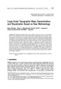
Study Area and Field Methods The SPF function was tested, and its use illustrated, via applications to a soil landscape in eastern North Carolina. The North Carolina (NC) coastal plain is a ¯at to gently rolling region underlain by unconsolidated marine, coastal, and ¯uvial sediments of Pliocene to Holocene age. The climate is humid subtropical, with mean annual precipitation in the study areas of about 1200 mm yr - 1 . The dominant soil order on uplands is Ultisols, which are highly weathered, acidic soils with argillic horizons and characterized by low base saturation. The two study sites, the Clayroot and Little®eld sites (Figure 3), are in Pitt County, NC, near the villages of Clayroot and Little®eld, Both are small agricultural watersheds used for a multiyear-study of soil erosion, transport, deposition, and redistribution studies (Slattery et al., 1998). Soils were mapped in detail at both sites in connection with the latter study. Data from both the Clayroot and Little®eld sites are based on detailed soil maps produced at a scale of 1:3700 and 1:3550, respectively. Published soil maps for the sites are not consistent with contemporary taxonomy, were found to be inaccurate, and in any case lack the resolution required for the geomorphic and hydrological studies at the site (see Slattery et al., 1998). Thus the soils at the Clayroot and Little®eld sites were ®eld-mapped at a detailed scale. The mapping is based on a combination of soil pits and trenches, soil auger and probe sampling, and soil exposures in drainage ditches and canals. At Clayroot three pits were excavated, and a total of 274 auger or probe samples were taken at 10 m intervals along one or more transects across each ®eld at the 19.4 ha study area. In the 71 ha Little®eld site there were two pits, two trenches, 33 shallow excavations at apparent sites of soil deposition or redistribution, and 260 auger or probe samples.
48
Jonatha n D. Phillips
Figure 3. Soil maps and location map for the Clayroot and Little®eld study sites. Sample transects are shown on the soil maps.
Spatial Structures and Scale
49
At both sites, additional excavations and probe samples were taken on an ad hoc basis to con®rm soil mapping and in conjunction with goals of the geomorphic studies (Phillips et al., 1999a, b). Soils were described and classi®ed based on standard methods (Soil Survey StaV, 1993), and their morphology and landscape relationships are described in detail elsewhere (Phillips et al., 1999a, b). Soil maps of Clayroot and Little®eld (Figure 3) were produced based on the ®eldwork. Linear transects were drawn on the soil maps for sampling at 1 mm intervals. This sampling interval represents 3.7 and 3.55 m on the ground, respectively, for the two study areas. While the precise starting and ending points of these transects were randomly selected, their general locations were arbitrarily chosen to examine diVerent soil landscape patterns. At Little®eld, for instance, transect A was chosen to re¯ect the full range of soil variability mapped at the site. Transect B was selected to examine a situation where a large portion of the transect is occupied by a single soil type. Transect C was picked to re¯ect a situation where two distinct geomorphic settings are encountered. The soil mapping units in each sample were simply ranked on an integer scale according to similarity. For example, a sample of ®ve soils would be ranked from 1 to 5, with soils 1 and 5 the most dissimilar, and soils one ranking apart the most similar. The rankings are unique to each sample so that the same soil series may have diVerent rankings in diVerent transects. This is the simplest possible way to assign similarity values, which need not be integers and which could have variable intervals between ranked soils. More precise and detailed assignments of similarity values could work as well. Experiments with more complex ranking schemes did not materially change the outcome of this particular analysis, so the simple system is retained here. The ranking was based on genetic and morphological properties (Table 1). The Norfolk, Goldsboro, Lynchburg and Rains soils are formed in the same parent material and are part of a drainage catena (well to poorly drained). They diVer substantially only in properties related to drainage and water table depth. The Wagram series diVers from the Norfolk only in having thicker A and E horizons. The Arenic and Grossarenic Paleaquults are the poorly drained parts of a local drainage catena where Wagram is the well-drained member. The Podzolized Ultisols (see Phillips et al., 1999a, b) represent Norfolk, Wagram, and Arenic/Grossarenic Paleaquult soils buried by sandy aeolian deposits, and thus occupy one extreme of the rankings. The Lenoir, Bladen, and Bayboro series are generally ®ner than the other soils at the sites and are poorly drained. They occupy the opposite end of the rankings, most closely related to the more poorly drained members of the Norfolk catena. The relationships among these soils at the regional scale are outlined in detail by Daniels et al. (1984) and Phillips (1990). The local soil geography and geomorphology at the study sites, and detailed characteristics of the soils, are discussed by Phillips et al. (1999a, b). Straight-line transects were used due to a deliberate eVort to produce SPF plots for qualitatively diVerent spatial patterns of soils. However, the SPF does not require a linear transect, and any regularly spaced set of sampling points including grids, triangular lattices, and non-linear transects would suYce. Application to a Vertical Sequence The SPF function can be applied to a vertical feature to address questions in the temporal domain. This is illustrated here with respect to a bisequal soil. The origin
50
Jonatha n D. Phillips Table 1. Taxonomy a and similarity rankings of soils at the study sites
Clayroo t transects A and B Podzolized Ultisolsb Wagram Norfolk Goldsboro Lynchburg Lenoir Bladen LittleWeld transect A Podzolized Ultisolsb Arenic & Grossarenic Paleaquultsc Wagram Goldsboro/Wagramd Norfolk Rains/Lynchburg Rains LittleWeld transect B Podzolized Ultisolsb Arenic & Grossarenic Paleaquultsc Wagram Goldsboro/Wagramd Norfolk Buried Bayboro Bayboro LittleWeld transect C Wagram Norfolk Rains Buried Bayboro Bayboro
Spodic Paleudult Arenic Kandiudult Typic Kandiudult Aquic Paleudult Aeric Paleaquult Aeric Paleaquult Typic Albaquult
1 2 3 4 5 6 7
Spodic Paleudult
1 2 3 4 5 6 7
Arenic Kandiudult Arenic Kandiudult/Aquic Arenic Paleudult Typic Kandiudult Typic Paleaquult/Aeric Paleaquult Typic Paleaquult Spodic Paleudult Arenic Kandiudult Arenic Kandiudult/Aquic Arenic Paleudult Typic Kandiudult Thapto-Umbric Paleaquult Umbric Paleaquult
1 2 3 4 5 6 7
Arenic Kandiudult Typic Kandiudult Typic Paleaquult Thapto-Umbric Paleaquult Umbric Paleaquult
1 2 3 4 5
a Classi®cation
to subgroup level, US Soil Taxonomy. are soils, generally Norfolk and Wagram, buried by sandy aeolian sediments, in which secondary podzolization is occurring. c This is a soil complex composed of soils similar to the Rains series, but with substantially thicker sand and loamy sand sur®cial horizons. d This is a soil complex consisting of the Wagram series and a soil that is similar to the Wagram, but somewhat poorly drained, and similar to the Goldsboro, but arenic. b These
of bisequal soils (soils with two vertical horizon sequences) is uncertain. Though the de®nition of bisequal soils holds that the sequa should have formed contemporaneously, this situation is diYcult to distinguish from features inherited from parent material, or from the eVects of secondary pedogenesis in deposits overlying buried soil pro®les. The Little®eld and Clayroot sites contain soils with multiple horizon sequences, but these are known to result from secondary pedogenesis in sandy aeolian deposits (Phillips et al., 1999a, b). The SPF was applied to the Mandarin soil series (sandy, siliceous, thermic Oxyaquic Alorthods), a bisequal soil mapped in eastern North Carolina and elsewhere in the southern Atlantic Coastal Plain (NCSS, 2000). The oYcial series description for the Mandarin was taken from the US Department of Agriculture’s oYcial series descriptions database (Table 2; NCSS, 2000). The LangleyTurnbaugh and Evans (1994) index of soil development was applied to each horizon
Spatial Structures and Scale
51
Table 2. Pro®le description of the Mandarin series at the type location, taken from NCSS (2000). Values of the Langley-Turnbaug h and Evans (1994) development index are shown in brackets for each horizon TYPICAL PEDON: Mandarin ®ne sand, on a smooth convex 0.5% slope, in forest. (Colors are for moist soil.) AÐ0 to 4 inches; dark gray (10YR 4/1) ®ne sand; weak ®ne granular structure; very friable; extremely acid; clear wavy boundary (2 to 8 inches thick). [150] E1Ð4 to 8 inches; light brownish gray (10YR 6/2) ®ne sand; single grained; loose; extremely acid; clear wavy boundary. [110] E2Ð8 to 26 inches; light gray (10YR 7/1) ®ne sand; single grained; loose; strongly acid; abrupt wavy boundary. (Combined thickness of the E horizon is 10 to 24 inches.) [95] Bh1Ð26 to 30 inches; very dark grayish brown (10YR 3/2) ®ne sand; weak ®ne subangular blocky structure; friable; in places sand grains well coated with organic matter; very strongly acid; gradual wavy boundary. [200] Bh2Ð30 to 35 inches; very dark brown (10YR 2/2) ®ne sand; weak ®ne subangular blocky structure; friable; in places sand grains well coated with organic matter; few medium faint dark brown (10YR 3/3) soft masses of iron accumulation; very strongly acid; clear wavy boundary. [235] Bh3Ð35 to 40 inches; black (5YR 2/1) ®ne sand; moderate medium subangular blocky structure; friable; in places sand grains well coated with organic matter; few ®ne prominent yellowish brown (10YR 5/4) soft masses of iron accumulation; very strongly acid; gradual wavy boundary. (Combined thickness of the Bh horizon is 5 to 35 inches.) [260] BEÐ40 to 46 inches; brown (10YR 5/3) ®ne sand; single grained; loose; moderately acid; gradual smooth boundary (0 to 22 inches thick). [125] E¢1Ð46 to 56 inches; light gray (10YR 7/2) ®ne sand; single grained; loose; slightly acid; gradual wavy boundary. [100] E¢2Ð56 to 62 inches; white (10YR 8/1) ®ne sand; single grained; loose; few medium faint very pale brown (10YR 7/3) soft masses of iron accumulation; neutral; gradual wavy boundary. [110] E¢3Ð62 to 73 inches; grayish brown (10YR 5/2) ®ne sand; single grained; loose; neutral; gradual wavy boundary. (Combined thickness of the E¢ horizon is 0 to 30 inches.) [120] B¢hÐ73 to 80 inches; black (10YR 2/1) ®ne sand; few ®ne distinct white (10YR 8/1) bodies; weak ®ne subangular blocky structure; friable; in places sand grains coated with organic matter; moderately acid. [205] TYPE LOCATION: Duval County, Florida; 3000 feet north of Atlantic Boulevard, 0.7 mile west of Girvin Road in NE1/4NW1/4, Sec. 22, T. 2 S., R. 28 E.
described in the database, producing index values of 95 to 260. Higher values indicate a greater degree, and lower values a lesser degree, of pedogenic development. The application and calculation of the index is described in Table 3. The system states and degrees of diVerence between sample points are de®ned by the pro®le development index. The top, A horizon, for each example, has an index value of 150 and is 4 in. thick. Thus the ®rst four values in the sequence have a value of 150. This produced a sequence of 80 values for the 80 in. pro®le description, with 10 diVerent index values (there are 11 horizons but two, the E1 and E ¢2, have the same value). If the dual horizon sequences are inherited from parent material layering or from multiple depositional episodes the SPF plot should exceed the expected random value at some lag. This is because at some distance the comparisons will be dominantly between horizons formed from diVerent materials or at diVerent times and there should be `repulsion’; i.e. a higher likelihood of ®nding diVerent degrees of development than would be expected in a random sequence. If the sequa formed contemporaneously (i.e. are acquired during pedogenesis rather than inherited), the SPF plot should stay below the expected random value.
52
Jonatha n D. Phillips
Table 3. Development index (modi®ed slightly and simpli®ed from LangleyTurnbaugh and Evans (1994). The index is the sum of the point totals assigned below A. Moist Munsell Color (rubi®cation and melanization) 1. 10 points for each increase in hue redness 5Y 5 0 points to 10R 5 80 points 2. 5 points for each increase in chroma for chroma 0 to 4; 10 points for each increase 4 to 8 0 5 10 points; 4 5 30 points; 8 5 70 points 3. 10 points for each decrease in value (increase in darkness) 2 5 90 points; 10 5 10 points B. Clay ®lms. Points assigned for each increase in abundance, thickness, and location of clay ®lms 1. very few 5 10 points; few 5 20; common 5 30; many 5 40; continuous 5 50 2. thin 5 10 points; moderately thick 5 20; thick 5 30 3. 10 points for pore linings; 20 for ped faces or bridging grains C. Dry or moist consistence. 10 points for each increase in hardness 1. loose 5 10 points to extremely ®rm 5 60 points (moist) loose 5 10 points to extremely hard 5 60 points (dry) D. Structure (grade and type) 1. weak 5 10 points; moderate 5 20; strong 5 30 2. massive or single grained 5 0 points; granular 5 5; platy 5 10; blocky (angular or subangular) 5 30; prismatic or columnar 5 40 E. Cutans or cementing agents common: 50 points
Results Clayroot and LittleWeld Soil Maps The soil geography, pedology, and geomorpholog y of the sites is described in detail elsewhere (Phillips et al., 1999a, b). The SPFh values were plotted against h for each transect, up to a value of h equal to approximately 25% of the total length of the sample transect. Transect A at Clayroot (Figure 4) does not reach a sill value, indicating that spatial dependence persists up to at least h 5 25 (92.5 m), and that the farther apart one
Figure 4. SPF plot for Clayroot transect A.
Spatial Structures and Scale
53
Figure 5. SPF plot for Clayroot transect B.
gets up to at least that distance, the more diVerent the soils are likely to be. This re¯ects the fact that one end of the transect is dominated by the poorly and somewhat poorly drained Bayboro and Lynchburg soils, while the other is the well-drained Norfolk/Wagram complex. Likewise, Clayroot B (Figure 5) has an unbounded SPF plot which accurately re¯ects diVerent soil suites characterizing either end of the transect. Both samples, particularly transect A, have values well below that expected for a random sequence. The spatial structure is thus characterized by persistence and contiguity over distances of about 100 m or less. The higher SPF values in transect B re¯ect a more irregular pattern, which includes some small soil bodies which do not show up on the publication-size map. The transects at Little®eld were purposefully chosen to re¯ect three diVerent soil map trends, and the SPF plots re¯ect this. Transect A (Figure 6), chosen to re¯ect the full variety of soils mapped at the site, reaches a sill at h 5 15 and a maximum
Figure 6. SPF plot for Little®eld transect A.
54
Jonatha n D. Phillips
Figure 7. SPF plot for Little®eld transect B.
at h 5 16 (about 55 m). The maximum value is above the expected value for a random sequence (0.326), but the slight downturn in the graph suggests that the sill value is roughly equal to SPF random. The Little®eld B plot (Figure 7) clearly shows the in¯uence of having roughly half the sample occupied by a single contiguous soil type, as the SPF reaches a sill value of only 0.2. There are three regions of the plot. The SPF rises relatively steeply from h 5 1 to 16 (4 to 57 m), steadily but less steeply from h 5 16 to 25 (60 to 89 m), and shows no spatial dependence beyond h 5 25 (90 m). Little®eld transect C (Figure 8) re¯ects a diVerent situation. Not only does it follow a lowland-to-upland gradient, but also incorporates two distinct environments. At the lower end of the transect, soil parent materials are poorly drained alluvial terrace sediments of the Bayboro and buried Bayboro types. The upper end is typical
Figure 8. SPF plot for Little®eld transect C.
Spatial Structures and Scale
55
Figure 9. SPF plot for Mandarin soil pro®le (Table 2). The ®nal data point represents the expected random value. coastal plain upland parent material, and may be further subdivided into a welldrained portion (Norfolk and Wagram) and a poorly drained area (Rains). It may also be noted that, unlike any other transect in this study, all individual soil types occur in single contiguous groupings along the sample. The result is that the SPF plot not only displays unbounded variation, but reaches a very high SPF value of about 0.6. From h 5 6 (21 m) onward, the SPF exceeds the expected value for a random sequence when q 5 5 (0.32). This means that over distances greater than about 20 m, the spatial dependence is in the form of repulsion or dispersalÐpairs of sites are more likely to be diVerent than similar.
Mandarin Soil ProWle The SPF plot for the vertical sequence of the Mandarin soil pro®le is shown in Figure 9. The plot exceeds the expected random value at all lags greater than about 12 in. (30 cm). On average, points more than about a foot apart in the vertical sequence diVer more in their degree of pedogenic development than would be anticipated in a random sequence. The interpretation is similar to that of Figure 8, and in this case suggests that the dual horizon sequences are inherited. Because the Mandarin is formed in sandy marine sediments such as coastal dunes, it is likely that multiple depositional episodes account for the vertical variations.
Discussion The SPF function provides a means for quantifying spatial scale and structure in categorical maps. For the testing and illustrative purposes of this study, the SPF was applied to transects where the qualitative nature of the spatial pattern was already known, so that the SPF plots could be examined for ®delity to phenomena observed in the ®eld. However, the SPF could as easily be applied to a grid pattern or any
56
Jonatha n D. Phillips
other regularly spaced spatial lattice. DiVerence values were established on an integer scale, but non-integer metrics could as readily be used. The SPF provides at least some of the advantage s associated with analysis of categorical maps and with geostatistical analysis of point data. The SPF recognizes varying degrees of similarity rather than depending on a binary same:diVerent comparison. It also produces values lying along an intuitive 0 to 1 continuum. Comparison of the SPF plots for the synthetic random and chaotic sequences suggests that the SPF may be sensitive to deterministic complexity signals. This needs further investigation , particularly in view of the fact that real geographic data are unlikely to re¯ect pure deterministic chaos or white noise. There is also the potential to apply the SPF in the temporal domainÐfor example, in a dated stratigraphi c sequence. This, too, deserves further research. The application of the SPF to the detailed soil maps shows that the function is sensitive to known spatial properties. When the sample transects cross major soil boundaries where distinctly diVerent suites of soils exist on either side, the SPF plot is unbounded, re¯ecting the fact that greater dissimilarity accompanies greater separation distances. Likewise, the plots are bounded when no such boundaries are crossed. The SPF values accurately re¯ect the degree of spatial variability, rising for more complex and varied patterns. The application to the vertical sequence illustrates the potential to use the SPF function in the temporal domain to address questions such as whether vertical variations are inherited or acquired. In the case of the bisequal Mandarin soil, the repulsion evident in the SPF plot suggests multiple depositional episodes. Note that the information here is too limited to settle the question of how the Mandarin horizon sequences formed; the point is to illustrate the use of the SPF in the vertical dimension to address a temporal question.
Conclusions The state probability function is a useful tool for evaluating the spatial structure of landscapes represented as categorical maps. It allows the construction of a plot which can be interpreted similarly to a variogram , and has the additional advantag e of having a prede®ned, ®nite range and a reference value associated with randomness. SPF analyses of data from detailed soil maps from eastern North Carolina show the function to be appropriately sensitive to major landscape boundaries across which the suite of soil types changes, and to the degree of clustering of similar units.
Acknowledgements The ®eldwork at the Little®eld and Clayroot sites was supported by US Department of Agriculture grant number 95±37107±2180. Paul Gares and Mike Slattery did most of the work on that project, leaving me free to dig holes.
References Bregt, A.K., Stoorvogel, J.J., Bouma, J. & Stein, A. (1992) Mapping ordinal data in soil survey: a Costa Rican example. Soil Science Society of America Journal, 56, 525±531. Daniels, R.B., Kleiss, H.J., Buol, S.W., Byrd, H.J. & Phillips, J.A. (1984) Soil Systems of North Carolina. Raleigh: NC Agricultural Research Service Bulletin 467.
Spatial Structures and Scale
57
Forman, R.T.T. (1995) Land Mosaics. New York: Cambridge University Press. Fridland, V.M. (1976) The Pattern of the Soil Cover (translated from Russian). Jerusalem: Israel Program for Scienti®c Translations. Goovaerts, P. (1999) Geostatistics in soil science: state-of-the-art and perspectives. Geoderma, 89, 1±45. Gustafson, E.J. (1998) Quantifying landscape spatial pattern: what is the state of the art? Ecosystems, 1, 143±156. Haines-Young, R. & Chopping, M. (1996) Quantifying landscape structure: a review of landscape indices and their application to forested landscapes. Progress in Physical Geography, 20, 418±445. Hole, F.D. & Campbell, J.B. (1985) Soil Landscape Analysis. Totowa, NJ: Rowman & Allanheld. IbaÂnÄez, J.J., De-Alba, S., Bermudez, F.F. & Garcia-Alvarez, A. (1995) Pedodiversity: concepts and measures. Catena, 24, 215±232. Kupfer, J.A. (1995) Landscape ecology and biogeography. Progress in Physical Geography, 19, 18±34. Langley-Turnbaugh, S.J. & Evans, C.V. (1994) A determinative soil development index for pedostratigraphic studies. Geoderma, 61, 39±59. May, R.M. (1976) Simple mathematical models with very complicated dynamics. Science, 261, 459±467. McBratney, A.B. (1998) Some considerations on methods for spatially aggregatin g and disaggregatin g soil information. In: P.A. Finke, J. Bouma & M.R. Hoosbeek, Eds, Soil and Water Quality at DiVerent Scales. Dordrecht: Kluwer, pp. 51±64. NCSS (National Cooperative Soil Survey) (2000) OYcial Series Descriptions. US Department of Agriculture database, URL http://www.statlab.iastate.edu /cgi-bin/osd/. Oliver, M., Webster, R. & Gerrard, A.J. (1989) Geostatistics in physical geography. Part I: theory. Transaction s of the Institute of British Geographers, 14, 259±269. Phillips, J.D. (1990) Relative ages of wetland and upland surfaces as indicated by pedogenic development. Physical Geography, 11, 363±378. Phillips, J.D., Gares, P.A. & Slattery, M.C. (1999a) Truncation and accretion of soil pro®les on coastal plain croplands: implications for sediment redistribution. Geomorphology, 28, 119±140. Phillips, J.D., Golden, H., Capiella, K., Andrews, B., Middleton, T., Downer, D., Kelli, D. & Padrick, L. (1999b ) Soil redistribution and pedologic transformations in coastal plain croplands. Earth Surface Processes and Landform s, 24, 23±39. Slattery, M.C., Gares, P.A. & Phillips, J.D. (1998) Quantifying soil erosion and sediment delivery on North Carolina coastal plain croplands. Conservation Voices, 1, 20±25. Soil Survey StaV (1993) Soil Survey Manual. Washington: US Department of Agriculture, Handbook 18. Walsh, S.J., Butler, D.R. & Malanson, G.P. (1998) An overview of scale, pattern, process relationships in geomorphology: a remote sensing and GIS perspective. Geomorphology, 21, 183±205.