AAM and the Earth's rotation at high frequencies since this loss, ifreal, maybe related .... Because the Rogue receivers measure precise (P- code) pseudorange ...
GEOPHYSICAL RESEARCH LETTERS, VOL.18,NO. 10,PAGES 1893-1896, OCTOBER 1991
SUB-MILLL•RCSECOND DETERMINATION OF POLE POSITION USING GLOBAL POSITIONING SYSTEM DATA
Thomas A.Herring, Danan D0ng,andRobert W.King Massachusetts Institute ofTechnology, Cambridge, Massachusetts Abstract.We discussthe determination of pole-position variations fromthe analysis of 23 daysof GlobalPositioning
VLBI Data Analysis
System (GPS)datacontinuously collected witha globally
The VLBI groupdelayobservations wereanalyzedusing thetechniques described in Herring et al. [1991],exceptthat correctionsto the IERS Bulletin B valuesfor pole position
distributed, 21-stationnetwork. The comparison of the esti-
matedpolepositionsfrom thesedatawith resultsfrom 11 verylongbaselineinterferometry (VLBI) experiments con-
andtheEarth'saxial rotation(UT1-AT) were estimatedusing
ducted duringthis sameintervalyieldsweightedroot-mean-
station coordinates and secular velocities and radio source
square differences aboutthemeandifferences of 0.5masfor
positions obtained fromtheanalysisof-•1300 VLBI experimentsconducted betweenJuly 1980 andJanuary,1991. For eachday'sdatawe alsoestimated stochastic variations in the atmospheric delayandreferenceclockat eachof the sites
bothX- andY-polepositionestimates fromananalysis using single-day arcs,and1.0 and0.8 masfromananalysis using threeweeklymultiday arcs. Theseresultsare of sufficient [Herring etal.,1990].Corrections totheIAU-i980nutation qualitythatGPScouldprovidean alternative technique to VLB!andsatellitelaserranging(SLR) for regularmonitoring serieswerealsoestimatedon eachof the days. of high-time-resolution variationsin the positionof the' Theestimates of poleposition,alongwithcorrections tothe Earth's rotation axis. IERS BulletinB values,are givenin Table 1 for nearlyall of the VLBI experiments whichoverlapthe G!G-91 campaign. Introduction (Thoseexperiments notincluded in thetablewereeithersingle baseline experiments, or, in onecase,an experiment that Overthe last decadespace-based geodeticsystemshave hadnotbeencorrelatedcorrectly.) The VLBI analysisused becomethe sole instrumentation used for the determination of 6,563 groupdelay measurements in 12 experiments,with (rms)scatterof 30 ps (-•10ram)for variations intheEarth's rotation. Thet•wo systems nowused typical.root-mean-square eachex.perimenfi '..•' routinely arevery longbaselineinterferometry (VLBI) and satellite laserranging(SLR). Thesesystems arehowever, expensive to purchase andoperateespecially for highfrequency
GPSData Analysis
measurements.
Numerous studies have shown that variations in the Earth's
Wecarded outouranalysis oftheGPS observations intwo
rotation appearto be dominatedby variationsin atmospheric angular momentum(AAM), with the correlation beingsignificantfor periodsasshortasa fortnightandaslongasa couple ofyears(see,for example,Eubanks et al. [1988];Rosenet al. [1990]). In recentyears,therehasbeenanincreased interest
steps.In thefirststepwe used theMIT GPSAnalysisProgram(GAMIT) to performa leastsquares analysisof thecartier phaseobservations for eachof the 23 daysseparately.
Copyright 1991 by theAmerican Geophysical Union.
theinverse-squared-frequency partof thedispersive delaydue
Paper number 91GL02306_
to theionosphere. The least squaresanalysisof eachday's data was per-
Tables (ephemerides) forthemotions of thesatellites were
generated by numerical integration of initial ' conditions for in understanding the apparent lossof coherence between two 8-dayandone7-dayarcs,usingas a forcemodellunar AAM andthe Earth'srotationat highfrequencies sincethis andsolarperturbations, theGEM L2 gravitymodeltruncated loss, if real,mayberelatedto themechanism •at couples the •todegree andordereight,anda three-parameter modelfor forces.We alsonumerically integrated the atmosphere tothesolid' Earth.Afta pilotstudy totestthe non-gravitational (variational equations) for the satellites' utilityof the GlobalPositionSystem(GPS)for providing partialderivatives andvelocities withrespect totheinitialconditions pole-position estimates withhightemporal resolution, theIn- positions andnon-gravitational forceparameters [Ash,1972]. Using ternational Earth RotationService(IERS) organizeda camephemerides, alongwithnominal val. uesforthe paign inFebruary, 199!,tocontinuously monitor theEarth's thesesatellite valuesof Earthrotationp..arameter•s interporotation usingGPS.Thecomplete GPSIERSandGeodynam- sitecoordinates, expressions for the ics("GIG-91") campaign involved of order100stations using latedfromIERSBulletinB, andstandard andnutation, We6ompUted theortfichl values a variety of GPSreceivers. We discuss heretheanalysis of precession at boththeL1 andL2 frequenthedataobtainedfrom the 21 Roguereceivers[Thomas,' thecarrierphaseobservations residuals (observed - computed) foreach 1988]in thenetwork, andwecompare theestimates ofpole Ciesandformed station-satellitecombination. We then combined these"oneposition fromthisnetworkwiththoseobtained from11VLBI way"residuals asdoubledifferences (between satellites and experiments coveringthesameperiod. between •ites)in a'leastsqua/res analysis usingthealgorithm described by $chaffrinandBock[1988]. Our"observable" wasthelinearcombination(LC) of L1 andL2 thateliminates
0094-8534/91/9!GL-023 06503.00 !893
1894
Herringet al.- Sub-mi!liarcsecond PolarMotionUsingGPS
formedwith weakconstraints on all of theestimatedparametersin orderthattheiradjustedvaluesandvariance-covariance matrixcouldbe usedas inputfor the secondstepin ourprocessing. In additionto orbital parameterswhich included scalefactorsfor the directand Y-bias solarradiationpressure models,we estimatedfor eachday threecoordinates andone atmospheric delayparameterfor eachstation.Finally,we estimatedfor eachcontinuous seriesof observations a "bias"parameterto representthe unknownintegerambiguityin the doublydifferencedphase. For mosttrackingstations, continuitywasmaintainedfor the entireseveralhourvisibilityof a satellite; for a few sites,thereweregapsin thedatawhichnecessitated the introductionin our analysisof additionalbias parameters.Becausethe Roguereceiversmeasureprecise(Pcode)pseudorange, however,we wereoftenableto "connect" phaseacrossa gap and avoidintroducingan extrabiaspa-
rmeter (see,Blewin[ 1990]for a discussion of thetypeof algorithmused). Sincetheinter-station distances in thisexperimentwerelarge,we madeno attemptto resolvetheinteger phaseambiguityfor eachcontinuous series.The firststepin our analysisincluded(for 23 days)549,028 doublydifferencedobservations, with typicalrmsscatterof--0.! cycles(20 ram). We used 50 mm for the noise GPS data in the least-
squares analysisto (pa•ally) accountfor thetemporalcorre-
tionsasrandom walkstochastic processes withthepower spectral densityof thewhitenoisedrivingtherandom walk (seeHerringet al. [1990])setsuchthatchanges in theorientationparameters wereconstrained to ñ!0 masperday(one standard deviation).Sincetheseparameters weredetermined with standard deviations of lessthan0.5 mas,theweakconstraintimposedby therandomwalk effectivelyallowedinde-
pendent estimates oftheorientation parameters fromeach day of data.
During the IERS campaign,five of the GPS satellites (PRN's6, 12, !5, 17, 19) werebeingeclipsedby theEarth duringpartof theirorbits. For thesesatellites,we treated the
satellite state vector (initialCartesian position andvelocity) as a randomwalk with the stochastic processnoisesetsuchthat
theposition andvelocity wereallowed tochange eachdayby ñ10m andñ1 mm/sec, respectively. Solarradiation pressure scalefactors(directandY-bias)werealsoweaklyconstrained to allow+100% changes per day. Theseconstraints weresufficientlyweakthatthe orbitswereeffectivelytreatedassingle-dayarcs. The orbitsof the remainingsatelliteswere treatedin two differentways. In one analysis,we treatedthe
statevectorof eachsatellite orbitasa deterministic parameter, andestimatedone statevector,alongwith a directradiation pressure scalingfactoranda Y-biasscalingfactor,for eachof
lation between GPS residuals.
theweeklyarcs. In the otheranalysis,we allowedthestate
In the secondstepof our analysiswe combined theadjustmentsandvariance-covariance matricesfrom all 23 daysusing a Kalmanfilter program(GLOBK) developedfor the ("global")combination of VLBI experiments (seeHerringet al. [1990]for description of thebasicalgorithms used).We retained theweakconstraints on thestationpositions (+10 m)
vectorsto vary as a random walk with the sameconstraints as
with one set of station coordinates estimated from the full 23
daysof data,butdefinedtheorientation of thecoordinate systemby holdingfixed the pole positionandUT1-AT on the fu:stday at the interpolatediERS BulletinB value. For successivedays,we estimatedthepolepositionandUT1 varia-
those applied totheeclipsing satellites, i.e.,effectively singledayarcs.Sincethepoleposition is determined fromchanges of thesitescoordinates withrespectto thea priorievolution of thecoordinate system, thechanges in poleposition arewell definedevenfor single-day arcanalyses.Thisis notthecase forUT1-AT determinations whichrequirethatthelongitudes of the nodes of the satellite orbits be well defined.
Thepole-position estimates fromthemulti-dayandsingleday arc analysesare givenin Tables2 and 3 andareshown
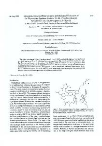
graphically, alongwith theVLBI results,in Figures1 and2.
Table1. X- andY-pole position estimates fromtheanalysis ofVLBIdatacollected during GIG-9!campaign. Date
Time*, hr:min
X pole, mas
AX?, rrx,mas mas
Y pole,
AY-{-,mascry,mas Network:•
mas
23 Jan. 23 Jan. 24 Jan. 28Jan. 31Jan. 2 Feb. 5 Feb. 7 Feb.
5:59 5:58 8:16 6:02 5:58 5:48 6:01 5:59
-51.9 -51.9 -55.1 -65.2 -78.2 -86.7 -98.9 -104.2
0.9 0.9 1.5 4.7 2.4 1.2 -0.1 1.6
0.1 0.2 0.3 0.1 0.2 0.2 0.2 0.1
90.8 91.1 91.7 99.0 103.8 106.9 110.7 113.1
2.5 2.9 2.3 4.6 4.7 4.5 4.3 3.7
0.1 0.2 0.3 0.1 0.2 0.1 0.2 0.1
8 Feb. 12Feb.
8:13 5:56
-108.4 -118.7
1.0 3.1
0.4 0.1
113.9 122.8
2.5 3.2
0.5 0.1
I: Ws, Ri, Mo, Wt U: Nr, Fa, Ku, Ma U: Nr, Ri, Fa, Ku I: Ws, Ri, Mo, Wt N: Pi, Mo, Fa, Ku, Wt I: Ws, Mo, Wt I: Mo, Fa, Ku, Ks I: Ws, Ri, Mo, Wt U: Nr, Fa, Ku I: Ws, Ri, Mo, Wt, On
12Feb. 14Feb.
5:54 -118.3 3.4 0.3 123.8 4.2 0.2 U:Nr,Fa,Ku,Ma 9:49 -127.! 1.2 0.3 127.2 2.3 0.3 U:Nr,Fa,Ku * UTCepoch ofthemiddle ofthe(24hour) VLBIexperiments. The po.le position isreferred tothis epoch. •' Difference oftheestimated value from a4-point Lagrangian interpolation ofthefinalvalues iniERSBulletins B37(Jan. 23toFeb. 2)and B38(Feb. 2toFeb.14)totheepoch oftheVLBIexperiment. Duetoaformat limitation intheGPS analy-
sis software thefinal values were rounded tothenearest millarcsecond before interpolation. Thetwo pairs ofvalues oneither sideof eachof theepochs wereusedin theinterpolation.
$ VLBINetwork. Thefirstletter denotes thescheduling organization: I isIRIS,UisUSNO, andNisNASA.Thetwocharacter code indicates theparticipating stations: Ws=Westford, Massachusetts; Nr=NRAO 85-3,WV;Ri=Richmond, Florida; Pi=Pietown, NewMexico; Mo=Mojave, California; Fa=Fairbanks, Alaska; Ku=Kauai, Hawaii; Ks=Kashima, Japan; Ma=Matera, Italy;Wt=Wettzell, Germany; On=Onsala, Sweden.'
1895
Herringetal.:Sub-milliarcsecond PolarMotionUsingGPS Table2. GPSestimates of X andY polepositionfromthe multi-dayarcanalysis.
'"-•ate*
X pole, z!Xt, Crx, Y pole, zlYt, mas
mas
mas
Date*
mas
mas
mas
22Jams 23Jan. 24Jan. 25Jan. 26Jan. 27Jan. 28 Jan. 29 lan. 30Jan.
-50.3 -52.4 -53.1 -54.3 -57.1 -60.5 -63.8 -67.8 -74.3
0.0 1.3 3.9 6.1 6.7 6.8 7.0 6.6 3.6
0.0 0.2 0.3 0.3 0.3 0.3 0.3 0.3 0.2
87.5 88.4 90.8 92.3 93.4 93.8 96.0 98.8 98.8
0.0 -0.1 1.2 1.5 1.4 0.5 1.3 2.4 0.9
0.0 0.3 0.3 0.3 0.3 0.3 0.3 0.3 0.3
31 Jan. 1 Feb. 2 Feb. 3 Feb.
-78.6 -83.1 -87.4 -91.5
3.0 2.1 1.5 1.0
0.2 0.2 0.2 0.2
100.2 100.6 102.9 103.2
0.6 -0.6 0.2 -0.8
0.3 0.3 0.3 0.3
4 Feb. 5 Feb.
-94.8 -98.0 - 100.2 -104.0 - 106.9 -109.3 - 111.4 - 116.2 -117.8 -123.0
1.3 1.7
0.2 0.2
103.6 106.7
- 1.8 -0.1
0.3 0.3
3.0 2.6 3.1 3.9
0.2 0.2 0.2 0.2
!07.7 109.7 111.5 112.3
-0.5 -0.1 -0.2 -1.3
0.3 0.3 0.3 0.3
4.9 3.3 4.8 2.6
0.2 0.2 0.2 0.2
114.4 117.6 120.2 122.2
- 1.3 -0.2 0.0 -0.4
0.3 0.3 0.3 0.3
6 Feb. 7 Feb. 8 Feb. 9 Feb. 10 Feb. 1! Feb. 12 Feb. 13 Feb.
Table3. GPSestimates of X andY poleposition fromthe single-day arcanalysis.
* Theepochof theGPSdetermination is 12:00UTC (the
X pole, z•$, mas
Crx, Y pole, Z•Y?, Cry,
mas
mas
22 Jan.$ -50.3
0.0
0.0
23 Jan. 24 Jan. 25 Jan. 26 Jan. 27 Jan. 28 Jan. 29 Jan. 30 Jan. 31 Jan. 1 Feb. 2 Feb. 3 Feb. 4 Feb. 5 Feb. 6 Feb. 7 Feb. 8 Feb. 9 Feb. 10 Feb. 11 Feb. 12 Feb. 13 Feb.
0.6 2.1 4.7 5.6 5.1 4.6 4.1 3.0 1.9 1.3 0.9 -0.6 0.1 0.1 1.2 2.4 1.9 2.0 2.7 2.7 3.2 2.7
0.3 0.4 0.4 0.4 0.4 0.4 0.4 0.3 0.3 0.3 0.4 0.3 0.3 0.3 0.3 0.3 0.3 0.3 0.3 0.3 0.3 0.3
-53.0 -54.9 -55.7 -58.3 -62.2 -66.2 -70.2 -74.9 -79.6 -83.9 -87.9 -93.1 -96.0 -99.6 -102.1 - 104.3 -108.1 -111.2 -113.7 -! 16.8 -119.3 -122.8
mas
mas
mas
87.5
0.0
0.0
88.4 90.0 92.8 93.5 94.9 96.3 97.3 99.8 101.3 102.6 104.1 105.0 106.1 108.3 109.0 110.8 112.8 114.6 116.2 118.4 121.2 122.6
-0.1 0.4 2.1 !.5 1.6 1.6 1.0 1.9 1.7 1.4 1.4 1.0 0.8 1.5 0.8 1.0 1.1 1.0 0.6 0.6 1.1 -0.1
0.5 0.6 0.6 0.6 0.6 0.5 0.6 0.5 0.5 0.5 0.5 0.5 0.5 0.5 0.5 0.5 0.5 0.5 0.5 0.5 0.4 0.4
* T :1:SeeTable 2.
middleof the24 hourGPSexperiments). • Differenceof the estimatedvalue from the interpolated IERS Bulletin B tabularvalues (see Table !). Becausethe IERSvaluesare tabulatedat 0:00 UTC, the interpolatedvalueshereon the datesof the Bulletin B valuescan differ by
VLBI estimates usingthe two nearestGPS values. The uncertainty of thedifference wascomputed usingboththe
between-1.3 and 1.8 mas.
VLBI andGPS standarddeviations,and the weightedmeans
nnsscatters werecomputed fromthe11differ$ Onthisday,theinterpolated IF.RS BulletinB valueswere andweighted whichaladopted to definetheorientation of theGPScoordinate sys- encesfor eachof theanalyses.The GPSanalysis tem.
The GPS network consistedof 8 stationsin North America
(Algonquin, Ontario; Fairbanks, Alaska;Yellowknife, N. W. Territories; Victoria,BritishColumbia;and4 in S. Califor-
lowed stochasticvariationsin all orbital parametersagrees bestwith theVLBI andalsoshowsthe smoothest variationof
poleposition, suggesting that evenfor the non-eclipsing satellites the dynamicalmodelsare not adequate for accu-
the orbits of the GPS satellites. nia);Santiago, Chile;7 in Europe(Madrid,Spain;Matera, rately representing in the dynamical modelsis alsosuggested by the Italy;Wettzell,Germany;Delft, Netherlands; and3 in Nor- Deficiencies in thecomparison between way);Hartebeesthoek, S. Africa;Usuda,Japan;Yaragadee highZ2 perdegreeof freedom andCanberra,Australia;andKauai, Hawaii.
GPSandVLBI for themulti-dayarc analysis.
Thelargeexcursion in theX-poleposition whichisclearly seenin boththeGPSandVLBI analyses requires a change in
polarmotionexcitation of ~100mas(seeEubanks et al. Since wemadenoattempt to aligntheVLBI andGPSreference frames, we haveremoved meandifferences in eachof
[1988]fordefinitions) overa five-dayinterval.Although not obvious fromtheresults plotted(differences fromIERSBulletinB) thechanges in the Y-polepositionrequirean even
thefigures. Wealsoestimated variations inUT1-ATin the excitation (-200mas)overa similar interval.Prelimimulti-day arcanalysis buttheseresults showed muchmore larger of theatmospheric angular momentum (AAM) variation 04).5mrs)thantheVLBI results, suggesting that naryanalysis thatbothof theseexcitations there werelargeunmodeled perturbations inthenodes ofthe dataoverthisperiodindicates satellite orbits. Theseresultsare stillunderinvestigation and
willnotbepresented here(seealsoHerringandDong [1991]). Results and Discussions
can be accounted for by changesin atmospheric pressure. Thesedataarestillbeinginvestigated anddetailedresults will bepresented elsewhere.
Acknowledgments. Thisworkwassupported by theNa-
tionalScienceFoundation undergrantEAR-89-05560,the National Aeronautics and Space undergrants Tocompare theVLBIand GPS results, theGPS pole-posi-NAG5-538andNAG5-737,theAdministration National Oceanic andAtmotionestimates werelinearly interpolated totheepoch ofthe
1896
Herringet al.:Sub-milliarcsecond PolarMotionUsingGPS
5
5 4
3 2 1 0
-2
4 3 2 !
0 -1
21
26
31
Jan.
5
10
15
, ,
!
21 Jail.
Feb.
i
i
i
26
31
5
i
I
10
i
_
15
Feb.
Fig.1. Differences frominterpolated IERSBulletin BX-pole Fig.2. SameasFigure1 exceptthattheresultsarefromthe (a)andY-pole(b)position estimates determined byVLBI single-day arcanalysis.Theweighted meandifference,
(dots) andGPS(crosses connected bysolidline)fortheanal- weighted rmsscatter about thismean, andtheZ2perdegree of ysisthatusedweeklymulti-day orbitalarcs.Theerrorbars freedom are-0.1mas,0.5 mas,and1.7forX-pole,and2.6 are onestandard deviationcomputed from the (assumed mas,0.5mas,and0.9forY-pole,respectively. white)noisein thedata(50mmforGPSdata,and~10mm
forVLBIdata), andfortheVLBIdata analysis, from thepro-
cessnoiseusedin theKalmanfilter. A meanoffsetbetween
theVLBIandGPSresults hasbeen removed. TheweightedHerring, T. A., J.L. Davis,andI. I. Shapiro, Geodesy byra-
mean difference, weighted rmsscatter about thismean, and theZ2perdegree offreedom are-1.2mas,1.0mas,and10.8
diointerferometry: Theapplication of Kalman filtering to
forX-pole, and3.4mas, 0.8mas, and 4.8forY-pole, respec-
12581, 1990.
tively.
theanalysis of VLBI data,J.Geophys. Res.,95, 12561-
Herring, T.A.,B.A. Buffet, P.M.Mathews, andI. I. Shapiro, Forced nutations of theEarth:Influence of innercoredynamics 3. Verylongbaseline interferometry dataanalysis, J. Geophys. Res.,96, 8259-8274,1991.
spheric Administration undergrantNA90AA-D-AC481, and Herring, T. A., andD. Dong,Current andfutureaccuracy of theKerr-McGee Foundation. We aregrateful to thereEarth rotation measurements, inProceedings oftheChapsearchers attheJetPropulsion Laboratory andtheinstitutions manconference on GeodeticVLBI: MonitoringGlobal NOAAPublication, inpress, 1991. involved intheGIG-9 ! campaign forthecollection andrapid Change, dissemination of the Roguedata. We alsothankRichard Rosen, R.D.,D.A. Salstein, andT. M. Wood, Discrepancies
intheEarth-atmosphere angular momentum budget, J GeoRosen andDavidSalstein ofAERInc.forsupplying theatphys.Res.,95, 265-279, 1990. mospheric angular momentum data for January and February, 1991. Schaffrin, B.,andY. Bock, A unified scheme forprocessing GPSphase observations, Bull.Geod., 62,142-160,1988. References
Ash,M. E.,Determination ofEarthsatellite orbits, Tech. Note
Thomas, J.B.,Functional description ofsignal processing in theRogue GPSreceiver, JPLPub.88-15,JetPropulsion Laboratory, Pasadena, June,1988.
!972-5,258pp.,Mass. Instit. ofTechnol., Lincoln Lab.,
Lexington,!972.
T. A. Herring, D. Dong,andR. W. King,Department of Blewitt, Anautomatic editing algorithm forGPSdata, Geo- Earth, Atmospheric, and Planetary Sciences, MIT 54-618, phys.Res.Lett.,17, 199-202,1990. Eubanks, T. M.,J.A.Steppe, J.O. Dickey, R.D.Rosen, and
D.A.Salstein, Causes ofrapid motions oftheEarth's pole,
Nature,334, 115-119, 1988.
Cambridge,/VIA 02139.
(Received July16,1991; accepted August12, 1991.)