J Arid Land (2016) 8(6): 846–860 doi: 10.1007/s40333-016-0054-3 Science Press
Springer-Verlag
Summer atmospheric boundary layer structure in the hinterland of Taklimakan Desert, China WANG Minzhong1,2*, WEI Wenshou1,2, HE Qing1,2, YANG Yuhui3, FAN Lei1,2, ZHANG Jiantao1,2 1
Institute of Desert Meteorology, China Meteorological Administration, Urumqi 830002, China; Taklimakan Desert Atmospheric Environment Observation Experimental Station, Tazhong 841000, China; 3 School of Geographic Science and Tourism, Xinjiang Normal University, Urumqi 830054, China 2
Abstract: Understanding the characteristics of the structure of desert atmospheric boundary layer and its land surface process is of great importance to the simulations of regional weather and climate. To investigate the atmospheric boundary layer structure and its forming mechanism of Taklimakan Desert, and to improve the accuracy and precision of regional weather and climate simulations, we carried out a GPS radiosonde observation experiment in the hinterland of Taklimakan Desert from 25 June to 3 July, 2015. Utilizing the densely observed sounding data, we analyzed the vertical structures of daytime convective boundary layer and nighttime stable boundary layer in summer over this region, and also discussed the impacts of sand-dust and precipitation events on the desert atmospheric boundary layer structure. In summer, the convective boundary layer in the hinterland of Taklimakan Desert developed profoundly and its maximum height could achieve 4,000 m; the stable boundary layer at nighttime was about 400–800-m thick and the residual mixing layer above it could achieve a thickness over 3,000 m. Sand-dust weather would damage the structures of nighttime stable boundary layer and daytime convective boundary layer, and the dust particle swarm can weak the solar radiation absorbed by the ground surface and further restrain the strong development of convective boundary layer in the daytime. Severe convective precipitation process can change the heat from the ground surface to the atmosphere in a very short time, and similarly can damage the structure of desert atmospheric boundary layer remarkably. Moreover, the height of atmospheric boundary layer was very low when raining. Our study verified the phenomenon that the atmospheric boundary layer with supernormal thickness exists over Taklimakan Desert in summer, which could provide a reference and scientific bases for the regional numerical models to better represent the desert atmospheric boundary layer structure. Keywords: convective boundary layer; effects of sand-dust and precipitation; GPS radiosonde observation; the hinterland of Taklimakan Desert Citation: WANG Minzhong, WEI Wenshou, HE Qing, YANG Yuhui, FAN Lei, ZHANG Jiantao. 2016. Summer atmospheric boundary layer structure in the hinterland of Taklimakan Desert, China. Journal of Arid Land, 8(6): 846–860. doi: 10.1007/s40333-016-0054-3
The desert atmospheric boundary layer is an important and frontier domain of modern atmospheric science study. Recognizing deeply the characteristics of the structure of desert atmospheric boundary layer and its land surface process is of great importance to the simulations of regional weather and climate, and is helpful for improving the model performance to further increase the accuracy and precision of weather and climate simulations.
Corresponding author: WANG Minzhong (E-mail:
[email protected]) Received 2015-11-21; revised 2016-04-21; accepted 2016-05-08 © Xinjiang Institute of Ecology and Geography, Chinese Academy of Sciences, Science Press and Springer-Verlag Berlin Heidelberg 2016
http://jal.xjegi.com; www.springer.com/40333
WANG Minzhong et al.: Summer atmospheric boundary layer structure in the hinterland of Taklimakan…
847
In the past decades, domestic and foreign scholars have conducted many studies on the desert atmospheric boundary layer and land surface processes and achieved many significant achievements (Garratt, 1992, 1993; Gamo, 1996; Sivakumar, 2007; Huang et al., 2010). In the 1970s, Charney (1975) studied the albedo and thermal balance of Sahara Desert and the forming mechanism of arid climate, and found that the high surface albedo reduced the net radiation and resulted in the sinking motion in the desert, which reduced the precipitation. Since 1980s, Henderson-Sellers (1980), Gornitz and Nasa (1985), Cunnington and Rowntree (1986) and Lare and Nicholson (1990) conducted detailed analyses on the albedo of different underlying surfaces. Regarding the boundary layer, Marsham et al. (2008) observed a very thick convective boundary layer of 5,500 m with notable residual layer in the Sahara region. Taking advantage of conventional meteorological sounding data, Takemi (1999) analyzed the atmospheric boundary layer structure of Hexi Corridor region of China and conjectured the convective boundary layer with thickness of more than 4,000 m from the characteristics of residual layer. In China, Su and Hu (1987) firstly discovered the “cold-island effect” in the oasis of arid area in the 1980s. Later, Hu and Gao (1994) found the existence of inverse humidity in desert atmosphere adjoining to oasis in the “Heihe River Basin Field Experiment” conducted in the 1990s. To further understand the land-air interactions in typical arid regions, Chinese researchers (Zhang et al., 2007, 2011; Zhang and Wang, 2008) did field observation experiments in the Gobi desert of Dunhuang, Gansu province in 2000. By analyzing the atmospheric boundary layer structure and the land surface process features, they found that a convective boundary layer with the thickness of over 4,000 m exists on clear days in summer in this region. In addition, Wei et al. (2005) studied the wind, temperature and humidity of atmospheric boundary layer in summer over the Jinta oasis of Hexi Corridor, and found that the height of summer boundary layer in this region was about 3,500 m. Using balloon and GPS sounding, Li et al. (2014) investigated the structure of summer atmospheric boundary layer in Badain Jaran Desert and pointed out that the convective mixing layer on clear days in summer could reach up to 3,000 m. Taklimakan Desert is the second largest mobile desert in the world and extremely sensitive to climate changes in the arid region of Northwest China. The desert has harsh natural environment with extremely dry climate and large scope of mobile sand dunes. Compared with other arid regions in the world, its land surface process and atmospheric boundary layer structure are very unique and have an important influence on the regional weather, climate and atmospheric circulation. At present, researches on the atmospheric boundary layer of Taklimakan Desert are mainly about the near-surface meteorological observations and analyses (He et al., 2010a, b; Wen et al., 2010; Liu et al., 2012) by using near-surface meteorological observation equipment and remote sensing systems. Although fixed-point continuous observations can be realized, the detection heights and applicable weather conditions are greatly limited, resulting in the restriction of in-depth study of entire atmospheric boundary layer in this desert. He (2009) once studied the land-air interaction and the near-surface thermal structure of desert hinterland deeply and systematically by virtue of an 80-m meteorological tower, and estimated that the convective boundary layer of desert in summer was about 3,000 m. Xu et al. (2014) studied the atmospheric boundary layer structure of Taklimakan Desert using the NCEP (National Centers for Environmental Prediction) reanalysis data, and pointed out that the thickness of convective boundary layer could achieve 3,000–4,000 m. In our previous study (Wang et al., 2012), fiercely developed turbulence was noted on clear days in summer over the desert hinterland, which could reach a height of 3,500–4,000 m. However, the thickness of atmospheric boundary layer needs further verification through radiosonde observation. In this regard, we carried out a GPS radiosonde observation experiment from 25 June to 3 July 2015. Then we used the densely observed sounding data obtained in this experiment to analyze the vertical structures of daytime convective boundary layer and nighttime stable boundary layer, and discussed the effects of sand-dust and precipitation processes on the boundary layer structure. The purposes of this study are to understand more deeply the atmospheric boundary layer structure as well as its developing mechanism over the dry and mobile desert, and also to provide a reference to further study on
848
JOURNAL OF ARID LAND 2016 Vol. 8 No. 6
boundary layer parameterization in regional numerical models.
1
Study area
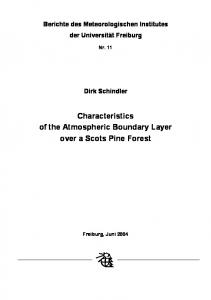
Taklimakan Desert is located in the hinterland of Eurasian continent in the mid-latitude of Northern Hemisphere, i.e. in the central part of Tarim Basin in Xinjiang, China. It has Tomur Mountains and Pamir Plateau to its west, Kunlun Mountains and Altun Mountains to its south, Tianshan Mountains to its north and Lop Nur to its east. It is about 1,070 km long from east to west and about 410 km wide from south to north with an area of 33.76×10⁴ km2. It is the second largest mobile desert in the world. In addition, it is a major sand-dust storm source in China. Due to the obstruction effect of Tibetan Plateau and its surrounding mountains, the Taklimakan Desert lies in an extremely arid region with dry winter and few rain in summer. The climate is characterized by sufficient light and heat, few precipitation, strong sunshine and large diurnal temperature difference. Combined with the sparse desert vegetation, a unique and extremely fragile natural ecosystem is formed. The GPS radiosonde was released at Tazhong (39°02′N, 83°38′E; Fig. 1), the hinterland of Taklimakan Desert, with an elevation of 1,109 m. The sounding observation field is about 9 km away from the Tazhong Meteorological Station, which is situated in the oil operation area where no sounding balloons are allowed to release. The observation field is an open area with the ground surface covered by mobile sand dunes. Here, the annual mean temperature is 12.1°C, but the highest temperature can reach 46.0°C. The mean annual precipitation is less than 30 mm, but the annual potential evaporation is 3,812.3 mm. East wind prevails in this area with an annual average wind speed of 2.3 m/s. On average, the annual sand-dust storm days are more than 30 d, blowing sand days over 70 d and drifting dust days even beyond 100 d. Such weather often appears through the whole spring and summer. A small amount of desert shrub plants grow in the living quarters of the test field. The underlying surface of the observation field can be representative of Taklimakan Desert.
Fig. 1
2
Sketch map of the study region and observation equipment
Data collection and methods
The GPS radiosonde system, radiation observation system and eddy-correlation detection system were used in the experiment (Fig. 1). The GPS sounding system is primarily composed of a surface receiver, an antenna and several sondes. Technical parameters of the GPS sounding system are provided in Table 1. The sounding balloons carried the sondes into sky, and the surface receiver received the radio signal which was transmitted by the sondes and worked out the meteorological information (including atmospheric temperature, humidity, pressure, wind direction and wind velocity). The sounding observation was carried out from 25 June to 3 July 2015, during which the sondes were released six times per day, at 01:15, 07:15, 10:15, 13:15, 16:15 and 19:15 (Beijing time), respectively. The rising speed of sounding balloons was about 300 m/min on average, and the balloons took about 15 min to complete one detecting process of boundary layer. The radiation observation system and eddy-correlation detection system were fixed near the Tazhong Meteorological Station. The radiation observation system was mounted
WANG Minzhong et al.: Summer atmospheric boundary layer structure in the hinterland of Taklimakan…
849
1.5 m above the ground and equipped with the advanced detecting sensors developed by the Kipp & Zonen Company in the Netherlands. The system could detect the total radiation, reflection radiation, atmospheric long wave radiation and ground long-wave radiation. Net radiation was calculated via the above-mentioned radiation components. All the data were collected at 0.1 Hz and recorded at an interval of 1 min. The eddy-correlation detection system refers to the R3-50 ultrasonic anemometer (Gill Instruments Ltd., UK). It was mounted at a height of 10 m and the data were collected at 20 Hz. The surface sensible heat flux was calculated by the eddy-correlation technique. The surface temperature was observed at the Tazhong Meteorological Station with the soil thermometer. Table 2 presents the major technical parameters of surface observation systems. Table 1 Type
GPS sonde
CF-06-A GNSS
Type Surface receiver
CFL-GNSS-JS
Table 2
Manufacturer Beijing Changfeng Micro-Electronics Technology Co., Ltd., China
Manufacturer Beijing Changfeng Micro-Electronics Technology Co., Ltd., China
Sensor
Measurement range
Temperature Humidity Pressure Wind speed Wind direction Receiving frequency range
–90°C–60°C 0–100% 3–1,080 hPa 0–150 m/s
Detection precision 0.1°C 1% 0.1 hPa 0.1 m/s
0°–360°
0.1°
±2°
Automatic frequency control precision
Antenna gain
Noise coefficient
400–406 MHz
2 KHz
>7 dB
2.7 dB
Error range ±0.2°C ±3% ±1.0 hPa ±0.15 m/s
Technical parameters of radiation observation system and eddy-correlation detection system
Equipment Short-wave radiometer (total radiation, reflection radiation) Long-wave radiometer (ground long-wave radiation, atmospheric long-wave radiation) Ultrasonic 3-D
Technical parameters of GPS sounding system
anemometer
Type
Manufacturer
CM21
Kipp & Zonen Company, Netherlands
CG4
Kipp & Zonen Company, Netherlands
Spectral range: 4.5–42.0 µm; sensitivity: 30 µv/(W/m2); warm-up drift: ≤4 W/m2; response time: getting to 63% in less than 8 s
Gill Instruments Ltd., UK
Sample frequency: 20 Hz; wind speed range: 0–45 m/s; precision: