41st Lunar and Planetary Science Conference (2010)
1980.pdf
SYSTEMATIC PROCESSING OF HIGH-RESOLUTION DIGITAL TERRAIN MODEL QUADRANGELS ON THE BASIS OF MARS-EXPRESS HRSC DATA. A. Dumke, M. Spiegel, S. van Gasselt, D. Neu, G. Neukum. Institute of Geosciences, Freie Universität Berlin, Malteserstr. 74-100, 12249 Berlin, Germany.
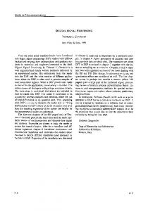
[email protected] Introduction: Since December 2003, the European Space Agency’s (ESA) Mars Express (MEX) orbiter has been investigating Mars. The High Resolution Stereo Camera (HRSC), one of the scientific experiments onboard MEX, is a pushbroom stereo color scanning instrument with nine line detectors, each equipped with 5176 CCD sensor elements. Five CCD lines operate with panchromatic filters and four lines with red, green, blue and infrared filters at different observation angles [1,2]. One of the goals for MEX HRSC is to cover Mars globally in color and stereoscopically at high-resolution. So far, HRSC has covered half of the surface of Mars at a resolution better than 20 meters per pixel. HRSC data allows to derive high-resolution digital terrain models (DTM), color-orthoimage mosaics and additionally higher-level 3D data products. Past work concentrated on producing regional data mosaics for areas of scientific interest in a single strip and/or bundle block adjustment and deriving DTMs [3,4]. The next logical step, based on substantially the same procedure, is to systematically expand the derivation of DTMs and orthoimage data to the 140 map quadrangle scheme (Q-DTM). Methods: The division of the Mars surface into 140 quadrangles is briefly described in Greeley and Batson [5] and based upon the standard MC 30 (Mars Chart) system. The quadrangles are named by alphanumerical labels (Figure 1). The workflow for the determination of new orientation data for the derivation of digital terrain models takes place in two steps. First, for each HRSC orbits covering a quadrangle, new exterior orientation parameters are determined. The successfully classified exterior orientation parameters become the input for the next step in which the exterior orientation parameters are determined together in a bundle block adjustment. Only those orbit strips which have a sufficient overlap area and a certain number of tie points can be used in a common bundle block adjustment. For the automated determination of tie points, software provided by the Leibniz Universität Hannover [6] is used. The bundle adjustment approach for photogrammetric point determination with a three-line camera is a leastsquares adjustment based on the well known collinearity equations. The approach estimates the parameters of the exterior orientation only at a few selected image
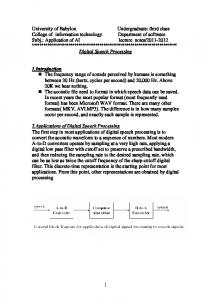
lines. Because of Doppler shift measurements estimating the position of the orbiter there are systematic variations in the observed exterior orientation. To model these variations in the bundle adjustment, additional observation equations for bias (offset) and drift have to be introduced. To use the MOLA DTM as control information, the least squares adjustment has to be extended with an additional observation equation for each HRSC point. These observations describe a relation between the MOLA DTM and the HRSC points [7,8]. The derivation of DTMs and ortho-image mosaics are performed using software developed at the German Aerospace Center (DLR), Berlin based on the Vicar environment developed at JPL. For the DTM derivation, the main processing tasks are first a prerectification of image data using the global MOLAbased DTM, followed by a least-squares area-based matching between nadir and other panchromatic channels (stereo and photometry) and finally, DTM raster generation. Results and Outlook: For the derivation of Q-DTMs and ortho-image mosaics, the use of the improved data (single strips and also image blocks) is essential because, among other things, they adapt the HRSCderived data to the global Mars-reference system very well. Figure 2 shows the Q-DTM MC18NW with a ground resolution of 100 m per pixel (shaded relief with superimposed color-coded heights). When compared to the MOLA DTM, the derived HRSC Q-DTM quadrangle shows significantly more detail and therefore allows more detailed geoscientific studies of Mars. The gaps in the Q-DTM quadrangles will be filled if MEX HRSC can achieve global coverage of Mars in upcoming years. The Q-DTM quadrangles will be distributed to the community as files in VICAR as well as Geo-JP2000 format. The map projection of the Q-DTM quadrangles will be, however, slightly different from the MC 140 scheme in the way that all quadrangles will be released in equidistant cylindric map projection except for the polar areas which will be stereographically projected. There will be several versions available as soon as new HRSC data is incorporated and MOLA PEDR are systematically used for merging and filling gaps (in particular in polar areas). After the derivation of all the Q-DTM quadrangles a global Mars HRSC DTM would be available.
41st Lunar and Planetary Science Conference (2010)
References: [1] Neukum, G., et al. (2004), ESA SP1240, 17-35. [2] Jaumann, R., et al. (2007), Planet. Space. Sci. [3] Dumke, A. et al. (2008), IntArchPhRS, 37, Part B4, 1037–1042. [4] Dumke, A., et al. (2009), LPSC 40th, Abstract‚ #1985. [5] Greeley, R. and Batson, R. M. (1990), Planetary Mapping, Cambridge University Press, New York, 266. [6] Schmidt, R. (2008), Dissertation, DGK C, 623, Verlag der Bayerischen Akademie der Wissenschaften, München. [7] Spiegel, M. (2007), IntArchPhRS, 36 (3/W49B), 161– 166. [8] Spiegel, M. (2007), Dissertation, DGK C, 610, Verlag der Bayerischen Akademie der Wissenschaften, München.
1980.pdf
ACKNOWLEDGEMENT: We thank the HRSC Experiment Teams at the German Aerospace Center (DLR), Institute of Planetary Research Berlin as well as the Mars Express Project Teams at ESTEC and ESOC for their successful planning and acquisition of data. This work is carried out as a pre-assessment of upcoming systematic tasks funded by the German Space Agency (DLR) Bonn through grant no. 50 QM 1001 and 50 QM 0301 .
Figure 1: Division of the Mars surface into 140 quadrangles
Figure 2: Q-DTM MC18NW (shaded relief with superimposed color-coded heights)