Jun 30, 2004 - ArcGIS, which is a major GIS desktop system, is enhanced with fuzzy set theory. ... and Fuzzy Inference System act as two separate applications. ... can be built with different languages including Visual Basic and Visual C++,.
The Enhancement of ArcGIS with Fuzzy Set Theory Tahsin A. Yanar and Zuhal Aky¨ urek
Abstract Geographic data, stored and processed in a GIS, form a conceptual model of the real world. The abstraction of the real world to construct the conceptual model unavoidably results in differentiation between objects of the real world and their representation in GIS (i.e., computer). Since classical set theory is used in conventional GIS software systems to model uncertain real world, the natural variability in the environmental phenomena can not be modeled appropriately. Because, pervasive imprecision of the real world is unavoidably reduced to artificially precise spatial entities when the conventional crisp logic is used for modeling. r In this study, a system to enhance commercial GIS software, namely ArcGIS° , with fuzzy set theory is designed and implemented. The proposed system allows users to (a) incorporate human knowledge and experience in the form of linguistically defined variables into GIS-based spatial analyses, (b) handle imprecision in the decision-making processes, and (c) approximate complex ill-defined problems in decision-making processes and classification.
1
Introduction
Geographic Information Systems (GIS) are computer-based systems that store and process (e.g. manipulation, analysis, modeling, display, etc.) spatially referenced data at different points in time [1]. Geographic data, stored and processed in a GIS, form a conceptual model of the real world [1]. The abstraction of the real world to construct the conceptual model unavoidably results in differentiation between objects of the real world and their representation in GIS (i.e., computer) [2,3]. Since the classical set theory used in a conventional GIS is inadequate to express natural variability in the environmental phenomena [2], there will often be meaningful discrepancies between reality and its representation [4]. Because, the reality is forced into rigid data storage formats [4]. Preprint submitted to ESRI International User Conference
30 June 2004
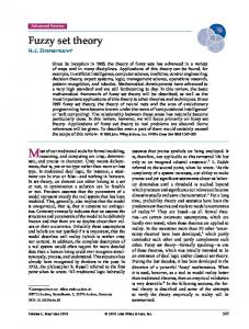
Since pervasive imprecision of the real world is unavoidably reduced to artificially precise spatial entities when the conventional crisp logic is used for modeling, an alternative approach fuzzy set theory, which provides a formal framework to represent and reason with uncertain information, can be used to model the real world. In this study, a commercial GIS software namely ArcGIS, which is a major GIS desktop system, is enhanced with fuzzy set theory. Component Object Model (COM) environment is used for developing fuzzy inference system for ArcMap, where COM is a protocol that connects one software component, or module, with another and defining the manner by which objects interact through an exposed interface. The implementation of the fuzzy inference system tool for a commercial GIS product, ArcMap is divided into two parts: (1) Fuzzy Inference Engine implementation, (2) Fuzzy Inference System Module implementation. The general architecture design and workflow of the fuzzy inference system for cell-based information modeling is shown in Fig. 1. Commercial GIS appli-
Fig. 1. Architectural design and workflow of Fuzzy Inference System for GIS.
cation uses Fuzzy Inference System through public interface defined by Fuzzy Inference System Module. The interface is a collection of logically related operations that define some behavior [5]. However, commercial GIS application and Fuzzy Inference System act as two separate applications. Fuzzy Inference System is designed as an ActiveX module. Within the Fuzzy Inference System Module, precompiled libraries Fuzzy Inference Engine and ESRI ArcObjects Library are used. Since Component Object Model (COM) 2
environment is used, applications can interact with objects only through their public interfaces. ESRI applications are COM clients; their architecture supports the use of software components that adhere to the COM specification [6]. Hence, components can be built with different languages including Visual Basic and Visual C++, and these components can then be added to the applications easily. Visual Basic and Visual C++ are used to create COM components to enhance the functionality of cell-based information modeling in the form of extensions. An extension is a component or a set of components that implements an interface that is expected by the application and registers itself with the application so that it may be loaded at the appropriate time. End-users can control what pieces of functionality are installed on a machine or loaded at run time. ArcGIS provides developers the key benefit of standard mechanisms for plugging extensions and other components into the system [6]. The developed system can be viewed as a scheme for capturing experts’ knowledge on a specific problem. Through the use of linguistic variables, experts’ experiences in the problem domain, even though they naturally involve imprecision, are converted to fuzzy rules. Therefore, the proposed system allows users to handle imprecision in the decision-making process by knowing only the fuzzy logic background. Easy to use graphical user interfaces (GUIs) enable users to define fuzzy rules without necessarily knowing all the underlying concepts of the fuzzy set theory [7].
2
Applications
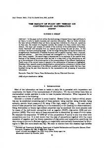
2.1 Decision Making One of the main tasks in GIS is making decisions using information from different layers. The decision-making is affected by many factors and sometimes needs many criteria. In numerous situations involving a large set of feasible alternatives and multiple, conflicting and incommensurate criteria, it is difficult to state and measure these factors and criteria [8]. Indeed most of the information about the real world contains uncertainties. In conventional decision-making process, a common type of operation is threshold model. For each of the criterion the study area is classified into two subregions describing whether a property value of a specific location is in the defined limit values or not. Then, maps produced for each criterion are overlaid using logical connectives (i.e., Boolean overlay). Each criterion can be weighted based on their importance to decision-maker. Such models can cause 3
Fig. 2. Slope map of the study area.
Fig. 3. Roads and proximity to roads.
problems since they are inherently rigid. On the other hand, the developed system can be used to make decisions capturing uncertain information using fuzzy set methodologies. In the sequel a set of criteria is used to select suitable sites for industrial development. For example, to select suitable locations for industrial development humans may pose criteria such as “If site has flat or gentle slope and if site is close to roads and town then site is suitable for industrial development”. To comprehend and make decisions based on these vague terms is simple for humans. However, the conventional GIS cannot answer such vague questions. The exact Boolean criteria for the industrial development site selection is: Site is suitable if (slope