sors, information technologies and programming tools ... Available at: http://starogradsko-polje.net/index.php ?p=5 [Ac- ... the 4th century BC (See also: [On line] Available at: https://www.youtube.com/watch? v=0PHEB TJff88 [Accessed on.
Inhalt
Franziska Steffensen, Feiko Wilkes Two recent AMLA projects: Excerpt of the lecture at the N.E.R.D. conference A logboat in the Schlei fjord/Underwater prospections on the mesolithic site Strande LA 163 Miran Erič, Gregor Berginc, Rok Kovačič, Kristijan Celec A short review of the application of 3D documentation methods on selected UW heritage sites in Slovenia and the Adriatic: the need for changes in methodology
16
24
Helena Novak Neolithic Lake Settlements. A new UNESCO World Heritage leads to the emerging of underwater- and wetland-research in Austria 36 Marie-Claire Ries New Research on a waterlogged Bronze Age Settlement in Lake Attersee (Austria)
46
Marina Nuovo Roman harbours: coastal and underwater landscapes in the central-southern Adriatic Sea
56
Julia Goldhammer, Martina Karle A fish trap basket from Belum (Ldkr. Cuxhaven). Excerpt from the presentation “Archaeology in the Wadden: Submarine Archaeology without a diving suit”
66
Margaret Logan A Study of a 16th-century wooden vessel from the Netherlands
72
Philipp Grassel Late Hanseatic seafaring from Hamburg and Bremen to Iceland, the Faeroe Islands and Shetland
82
Alexander Cattrysse Deviating from the Course: Clinker Deviations in Northern-European Carvel Shipbuilding
94
15
Miran Erič, Gregor Berginc, Rok Kovačič, Kristijan Celec
A short review of the application of 3D documentation methods on selected UW heritage sites in Slovenia and the Adriatic: the need for changes in methodology
Introdution In recent decades we have witnessed almost revolutionary changes in the documentation of underwater heritage. The research in this area was given a strong impetus by development of a special discipline within archeology, strongly stimulated by changes in research philosophy. It had outgrown the passion for collecting artifacts to engage in data collecting and a carefully considered, less invasive handling of heritage. Remote sensing of anthropogenic changes, enabled by the use of sonar equipment, especially in the archaeological research of larger local
and regional areas, brought a new ideological concept. It made archeologists alter their attitudes to heritage and opt for more non-invasive research techniques. Simultaneous technological development of measurement sensors, information technologies and programming tools have to revolutionary changes in the profession, enabling absolutely accurate documentation of sites. Some of these changes appeared also in the archaeological research in the Eastern Adriatic.
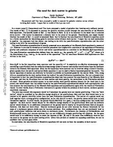
Fig. 1 Stari Grad Plain, Island Hvar, Croatia: Left (a): Early use of DEM; point density of 25 m to 25 m, interpolated reconstruction by Tomaž Podobnikar and Zoran Stančič (Institute of Anthropological and Spatial Studies (IASS) ZRC SAZU); application of satellite images processed by Krištof Oštir and Z. Stančič (IASS ZRC SAZU) (indication of the source) combined by historical analysis of Stari Grad Plain and landscape changes in the 19th century by rectificated cadastrial maps. Right (b): Detailed micro-analysis of the landscape structures survey of Greek modular parcellation and anthropogenic changes.
24
Fig. 2 Short promotional reconstructions and visualisation of the Stari Grad Plain in the time of Greek colonization in the 4th century BC (See also: [On line] Available at: https://www.youtube.com/watch? v=0PHEB TJff88 [Accessed on 24th March 2015]). The film was produced in 2004 by Miran Erič, Branko Kirigin and Božidar Slapšak (Erič/Kirigin/ Slapšak 2008) with the help of Zoran Stančič, Krištof Oštir and Tomaž Podobnikar (IASS ZRC SAZU) by means of DEM reconstruction of satellite images (LANDSAT TM 1998) in the production of ArtRebel9 company. Left: Silhouette of western part of the island Hvar with the Stari Grad Plain to the north. Right: A SW to NE view of the reconstruction of the probable ancient environment of the Stari Grad Plain.
Three dimensional (3D) documentation methods, used in recent decades in the research of underwater sites in the region
Digital Elevation Model - DEM (also Digital Terrain Model - DTM, and Digital Surface Model - DSM, which includes representation of the vegetation canopy and infrastructure) In Slovenia modern methods and datasets began to be used in archaeology in the 1980s when a group of researchers from the Department of Archaeology started experimenting with remote data capturing1. Remote sensing methods in surveying saw a quick and intensive growth due to availability of satellite imagery and development of photogrammetric methods, in particular stereo-photogrammetry, the by-products of which were digital relief models. Because of the nature of archaeological research, aiming predominately at discovery of anthropogenic changes in landscape, the latest findings and remote sensing results have opened up a completely new research area. They brought new knowledge, viewed from a fresh
1 Stančič/Šivic 1988, Stančič/Slapšak 1988.
perspective and with „new eyes“. The earliest testing of usefulness of remote sensing in the region was carried out in the test area of the Stari Grad Plain on the island Hvar. Since 1982, intensive research has been conducted within various projects on the island2. On the ground of the research achievements, the Stari Grad Plain was first nominated and then, in 2008, placed on the UNESCO World Cultural Heritage list as the best preserved cultural landscape of Greek colonization. This research showed great usefulness of the remote sensing methods applied. It was the first time that satellite images were used in the region to analyze the surface investigated and that a 3D DEM was produced by means of photogrammetry (Fig. 1a). The model was later used for a more detailed analysis of the location (Fig. 1b). Great usefulness of 3D spatial modeling became apparent when a 3D representation of the Stari Grad fields was produced, which offered the possibility of spatial appreciation of the size of this heritage site. It was exploited to produce a promotional film, which was added to the documentation for the UNESCO World Cultural Heritage nomination proposal and significantly contributed to its inclusion in the list in 2008 (Fig. 2). The first DEMs were not very clear due to the sparsity of points in the grid, the precision being conditioned by the quality and accuracy of publicly available satellite imagery. This methodology, based on analyses and comparisons of DEMs with the data collected from other sources made it possible to make a historical analysis and „clarification“ of latter-day, man-produced traces, and soon found
2 See the history of research of the Stari Grad plain. [On line] Available at: http://starogradsko-polje.net/index.php ?p=5 [Ac- cessed at 24th of March 2015].
25