Jan 26, 2012 - Packman and Mackay, 2003]. The hyporheic zone has been ... 1968; Harvey and Bencala, 1993; Woessner, 2000; Carde- nas et al., 2004] and ...
WATER RESOURCES RESEARCH, VOL. 48, W01538, doi:10.1029/2011WR011179, 2012
The use of multiobjective calibration and regional sensitivity analysis in simulating hyporheic exchange Ramon C. Naranjo,1,2 Richard G. Niswonger,2 Mark Stone,3 Clinton Davis,4 and Alan Mckay1 Received 20 July 2011; revised 20 November 2011; accepted 6 December 2011; published 26 January 2012.
[1] We describe an approach for calibrating a two-dimensional (2-D) flow model of
hyporheic exchange using observations of temperature and pressure to estimate hydraulic and thermal properties. A longitudinal 2-D heat and flow model was constructed for a rifflepool sequence to simulate flow paths and flux rates for variable discharge conditions. A uniform random sampling approach was used to examine the solution space and identify optimal values at local and regional scales. We used a regional sensitivity analysis to examine the effects of parameter correlation and nonuniqueness commonly encountered in multidimensional modeling. The results from this study demonstrate the ability to estimate hydraulic and thermal parameters using measurements of temperature and pressure to simulate exchange and flow paths. Examination of the local parameter space provides the potential for refinement of zones that are used to represent sediment heterogeneity within the model. The results indicate vertical hydraulic conductivity was not identifiable solely using pressure observations; however, a distinct minimum was identified using temperature observations. The measured temperature and pressure and estimated vertical hydraulic conductivity values indicate the presence of a discontinuous low-permeability deposit that limits the vertical penetration of seepage beneath the riffle, whereas there is a much greater exchange where the low-permeability deposit is absent. Using both temperature and pressure to constrain the parameter estimation process provides the lowest overall rootmean-square error as compared to using solely temperature or pressure observations. This study demonstrates the benefits of combining continuous temperature and pressure for simulating hyporheic exchange and flow in a riffle-pool sequence. Citation: Naranjo, R. C., R. G. Niswonger, M. Stone, C. Davis, and A. Mckay (2012), The use of multiobjective calibration and regional sensitivity analysis in simulating hyporheic exchange, Water Resour. Res., 48, W01538, doi:10.1029/2011WR011179.
1.
Introduction
[2] In the hyporheic zone, surface water infiltrates into the shallow subsurface material forming the channel bed and banks. This water follows the general down-valley gradient, and then returns to the river [Bencala, 2011]. In riffle-pool sequences with homogenous sediments, it is commonly understood that river water entering the riverbed at the head of a riffle returns to the river channel at the tail of the riffle near the transition to the pool [Vaux 1968; White, 1993; Winter et al., 1998]. Flow entering the riverbed can transport organic matter, nutrients, and dissolved oxygen that create environments for biogeochemical processes. Organic matter built up in sediment interstices, referred to as colmation, leads to a reduction of pore
1 Division of Hydrologic Sciences, Desert Research Institute, Reno, Nevada, USA. 2 U. S. Geological Survey, Carson City, Nevada, USA. 3 Department of Civil Engineering, University of New Mexico, Albuquerque, New Mexico, USA. 4 Division of Earth and Ecosystem Sciences, Desert Research Institute, Reno, Nevada, USA.
Copyright 2012 by the American Geophysical Union 0043-1397/12/2011WR011179
volume, consolidation of sediments, and decreased hydraulic conductivity [Brunke and Gonser, 1997; Brunke, 1999; Packman and Mackay, 2003]. The hyporheic zone has been shown to play a crucial role in river management and restoration [Boulton, 2007; Boulton et al., 2010], important environments for benthic invertebrates [Mermillod-Blondin et al., 2000; Franken et al., 2001; Bowker-Davy et al., 2006], biochemical reactions [Franken et al., 2001], nutrient cycling and dynamics [Triska et al., 1993; Dahm et al., 1998], and overall ecosystem health [Valett et al., 1994; Findlay, 1995; Brunke and Gonser, 1997]. [3] Hyporheic flow paths along a longitudinal direction have been shown to be strongly influenced by subsurface heterogeneity, river depth, and river curvature [Vaux, 1968; Harvey and Bencala, 1993; Woessner, 2000; Cardenas et al., 2004] and spacing of bed forms [Gooseff et al., 2006] and morphological features [Kasahara and Wondzell, 2003]. In early work, Vaux [1968] describes flow patterns that are either diverted back to the surface or forced deeper into the riverbed on the basis of varying riverbed topography and sediment heterogeneity. Harvey and Bencala [1993] showed the importance of lateral exchange in gaining conditions. Storey et al. [2003] investigated the key factors in controlling hyporheic exchange and showed the dependence of longitudinal and lateral gradients in
W01538
1 of 16
W01538
NARANJO ET AL.: USE OF MULTIOBJECTIVES IN HYPORHEIC EXCHANGE
controlling hyporheic exchange in a riffle pool sequence. Cardenas et al. [2004] show the impact of heterogeneity and boundary pressure effect on the shape and depth of exchange. The last two examples highlight the importance of simulating hyporheic exchange at variable temporal and spatial scales and as complex multidimensional heterogeneous systems. Exchange may occur laterally; however, simplifying the model extent to longitudinal 2-D in the thalweg of the channel helps reduce model complexity in defining the boundary conditions and estimating model parameters while simulating exchange along a continuous flow path. [4] Measuring fluid exchange at the riverbed interface does pose challenges in large river systems. Kalbus et al. [2006] describes several methods used in estimating exchange; however, the heat as a tracer method remains popular because of the relatively low cost data loggers and ease of deployment. Since the early applications in ephemeral channels, the heat as a tracer method has been shown to be robust in estimating seepage rates in a variety of river systems, and now has been widely accepted in perennial systems in measuring exchange under both gaining and losing conditions (see reviews by Stonestrom and Constantz [2003], Anderson [2005], and Constantz [2008]). Recent advances in using heat as a tracer include high-resolution synoptic mapping [Conant, 2004], thermal imaging [Loheide and Gorelick, 2006], and deployment of a distributed temperature sensor [Day-Lewis et al., 2006; Selker et al., 2006]. Several modeling approaches have been developed on the basis of application, conceptualization, and assumptions. Analytical solutions to heat and groundwater flow [Suzuki, 1960; Stallman, 1963, 1965; Hatch et al., 2006; Keery et al., 2007] have been used extensively for estimating seepage rates. However, these methods are limited to environments with vertical downward flow and sinusoidal temperature fluctuations [Lautz, 2010; Shanafield et al., 2011]. Given the assumptions used in analytical solutions, these equations are applicable for vertical seepage, not necessarily hyporheic flow. That is, a hyporheic flow path does not occur in any single direction, rather a flow path tends toward the vertical direction near the riverbed interface and tends toward the horizontal direction beneath the riverbed, such that simulating a flow path requires a multidimensional model. [5] In heat as a tracer applications, model calibration is typically achieved through manual trial and error methods [Ronan et al., 1998; Bianchin et al., 2010; Stonestrom and Constantz, 2003] or using automated parameter estimation techniques [Bartolino and Niswonger, 1999; Niswonger et al., 2005]. In both approaches, the calibration procedure is to minimize the differences between observed and simulated temperatures through adjustments of saturated hydraulic conductivity and thermal conductivity that represent a region or zone in the model domain. Typically, the simulated and observed temperatures are compared for the final set of calibrated parameters and parameter sensitivity is determined by manual adjustments to optimal hydraulic conductivity and calculating a percent deviation in seepage [Bianchin et al., 2010]. This sensitivity analysis approach does not consider nonuniqueness and parameter correlation that are typically found in multidimensional systems. [6] Improvements in model calibration have been made by coupling both temperature and pressure to constrain
W01538
estimates of hydraulic and thermal properties in evaluating groundwater discharge to rivers [Doussan et al., 1994, Bartolino and Niswonger, 1999] and in wetland systems [Bravo et al., 2002]. In a similar coupling approach, solute data and temperature data has been used to estimate transient storage parameters in a multiobjective framework [Neilson et al., 2011]. The use of multiple data types provides great potential for estimating both hydraulic and thermal parameters in hyporheic zone investigations. [7] Most applications using heat as a tracer to simulate exchange have not considered issues related to nonuniqueness and parameter identifiability. Nonuniqueness can be important in 2-D and 3-D modeling studies because of a greater number of sensitive parameters that need to be estimated during calibration. Because of the multidimensional flow patterns that occur in hyporheic systems, nonunique solutions in hyporheic flow models could also lead to large uncertainty in flux estimates. Niswonger and Rupp [2000] estimated the uncertainty in seepage estimates in an ephemeral channel caused by uncertainty in temperature measurements and thermal parameters using a Monte Carlo approach. Through the introduction of error into temperature and thermal parameters, they determined the uncertainty in thermal conductivity had a greater impact on seepage estimates than heat capacity. Ferguson and Bense [2011] used stochastic generation of hydraulic conductivity to estimate uncertainty in specific discharge using a onedimensional approach. They concluded that in areas with relatively high specific discharge and low variance in hydraulic conductivity, the one dimensional approach can provide reasonable results. In areas with greater variance in hydraulic conductivity and specific discharge less than 10�7 m s�1 will result in lateral flow and greater emphasis in determining the thermal conductivity term [Ferguson and Bense, 2011]. These conclusions have important implications for hyporheic investigations where heterogeneity and layering of riverbed deposits create contrasts in hydraulic conductivity, and influence thermal gradients and flow direction. [8] The uniform random search (URS) Monte Carlo approach is applied to estimate hydraulic and thermal parameters in a two-dimensional (vertical and longitudinal) heat and flow model of a 100 m section of a riffle-pool sequence on the Truckee River, Nevada. Our conceptual model of the subsurface heterogeneity was developed using observed temperature and pressure data to idealize deposits into 3 homogenous zones with different ranges in hydraulic properties. The specific objectives of this work were (1) to develop a flow model that represents hyporheic exchange through a riffle-pool sequence on the basis of continuous temperature and pressure measurements, (2) to evaluate the sensitivity and identifiability of parameters by visual observation of the solution space, (3) to determine the variability in the vertical and horizontal flux rates on the basis of a subset of the model simulations, and (4) to evaluate the relative amount of information provided by temperature and pressure observations. We incorporate principles of model calibration and sensitivity analysis that are typically used for rainfall-runoff model applications. [9] The modeling approach is used to demonstrate the effectiveness of coupling temperature and pressure measurements to estimate 2-D longitudinal flow through the
2 of 16
W01538
NARANJO ET AL.: USE OF MULTIOBJECTIVES IN HYPORHEIC EXCHANGE
hyporheic zone in a riffle-pool sequence. Furthermore, we recognize the importance of nonuniqueness as discussed the literature by the concept of equifinality [Beven, 2006], where multiple parameter sets can provide reasonable model results. We incorporate the equifinality concept by examining 5% of the ‘‘best’’ model simulations on the basis of both temperature and pressure to provide qualitative and quantitative examination of the uncertainty in our hyporheic zone modeling. Results are presented according to the RMSE statistic calculated from (1) a regional objective function that includes time series of observations from all observation locations at each zone and (2) a local objective function that only includes time series of observations from a single location. These two objective functions are further divided for further evaluation of model parameters given (1) temperature, (2) pressure, or (3) a combination of both temperature and pressure observations.
2.
Site Description
[10] The Truckee River drains from a basin area of 8000 km2 and encompasses the Sierra Nevada and the Basin and Range physiographic provinces. The river flows over a distance of approximately 184 km from Lake Tahoe to where it terminates at Pyramid Lake (Figure 1a). The study site is located on the lower Truckee River at Little Nixon, located 8 km from the mouth of Pyramid Lake. The precipitation in the Truckee River Basin mainly occurs as snowfall in the higher elevations and reaches the river as runoff or flow through the subsurface. [11] The riffle-pool sequence at the study area is approximately 20 m wide at the top of the reach and 15 m in the lower section. The depth of flow ranged between 0.20 m in the riffle and 1.3 m in the pool. The discharge at this location is largely controlled by reservoirs and agricultural diversions. The mean monthly flow ranges between 4.81 and 34.55 m3 s�1 at the USGS gauge 4.5 km upriver of the study area (USGS 10351700 Truckee RV NR Nixon NV). The bed material consists of medium size cobbles and gravels in the riffle and coarse sands to fine silts in the pool area. During low-flow conditions, the right side of the river is very shallow and an alcove of slow moving water forms
W01538
near P10 and P12 (Figure 1b). The study area was selected because of an up-river point source of nutrients (i.e., a wastewater treatment plant), presence of benthic algae, and its remote location. During periods of low flow, plant respiration and decaying plant material cause incidences of low dissolved oxygen that poses a threat to aquatic ecosystems in the region.
3.
Methodology
3.1. Installation and Data Collection [12] The study area was divided into 6 transects and instrumented with 16 in-river piezometers, and 4 shallow riparian monitoring wells positioned along the rifflepool sequence. The piezometers were installed to an approximate depth of 1 m beneath the riverbed and were placed perpendicular and parallel to the active channel (Figure 1b). The riverbed topography, river bank and monitoring points were surveyed and referenced to a local control point. The piezometers were constructed of 2.54 cm interior diameter schedule 80 PVC with a 20 cm screened interval starting from 10 cm from the bottom. The monitoring wells were installed within 5 m of the active channel and had screen lengths of 1.5 m. Piezometers were installed by driving a pilot hole using a 3.8 cm diameter metal rod. The rod was extracted by spinning the rod loose using a long pipe wrench for leverage. A 1.27 cm diameter galvanized rod was inserted into the piezometer capped with a Teflon drive tip. To assist with driving force, the top of the metal rod was equipped with a bolt and washers allowing the rod to fit snugly at the top of the piezometer. A posthole driver was used to drive the piezometer to the desired depth, or until refusal. [13] Seven additional nested minipiezometers (Rapid Creek Research, Boise Idaho) were installed to a depth of 20, 50, 100, and 150 cm below ground surface (bgs) at the riffle head and mid pool locations (NP1–NP7; Figure 1b). The minipiezometers are constructed of stainless steel tubes 0.635 cm diameter with a 3.2 cm welded collar at the top and a drive point welded at the bottom. There were small perforations with a 0.79 mm diameter spaced for 10 cm along the side of the piezometers. The last perforation
Figure 1. (a) The Truckee River watershed and (b) riffle-pool study area (39.801058� , �119.345166� ) showing piezometers (P1–P16), shallow riparian monitoring wells (MW1–MW4), minipiezometers (NP1–NP7), and the longitudinal transect, represented by the dashed line. 3 of 16
W01538
NARANJO ET AL.: USE OF MULTIOBJECTIVES IN HYPORHEIC EXCHANGE
was 5 cm from the bottom. The minipiezometers were driven into the riverbed to the desired depth using a sledgehammer. [14] The monitoring points were equipped with a vertical array of water tight Ibuttons temperature loggers called iBTags (Alpha Mach, Inc.) with an accuracy of 61.0� C and a resolution of 0.125� C. Individual calibration was used to correct and improve the accuracy to 60.25� C. The iBtags were attached to a stainless steel wire and placed at two depths, 20 and 50 cm below the riverbed surface. The pressure and temperature near or at 100 cm below ground surface was measured using pressure transducers that were compensated using local barometric pressure measurements. [15] Continuous stage was recorded along a longitudinal transect at P2, P5, and P15 (Figure 1b) using pressure transducers installed inside 10 cm PVC stilling wells attached to fence posts. Data was measured at 20 min intervals. The piezometers and monitoring wells were sealed with vented caps to prevent surface water from entering during high flows. [16] Relative water levels between the river and piezometers were used to characterize upwelling and downwelling zones. The vertical hydraulic gradient was calculated : VHG ¼ Dh/Dz, where Dh is the difference in head between the level in the piezometer and level of the riverbed surface and Dz is the depth from the riverbed surface to the midpoint of the screen [Dahm et al., 2006]. The direction of flow is indicated by the sign of the VHG, where negative values are downwelling zones. [17] Hydraulic conductivity was estimated using falling head tests for comparison to hydraulic conductivity estimated by the URS approach. Hydraulic conductivity was calculated from three repeat falling head tests. For each test, 1 L of river water was poured into the piezometer. Hydraulic conductivity was calculated using the Bower and Rice [1976] method [Halford and Kuniansky, 2002]. [18] Elevations of the river water surface, water levels in the piezometers and streambed temperatures were measured continuously at 20 min intervals from February–May 2009. Manual periodic water level (monthly to biweekly) measurements in minipiezometers were made from June 2008 to May 2009 using a depth sounder. Surface water levels were converted to pressure head at the riverbed surface and piezometer water levels were converted to pressure head at the midpoint of the screened interval for use in the VS2DH model. Pressure heads will be referred to as simply ‘‘pressure’’ for the remainder of this paper. 3.2. Model Description [19] The USGS variably saturated two-dimensional hydraulic model VS2DH [Healy, 1990; Healy and Ronan, 1996; Hsieh et al., 2000] was used to simulate heat and water flow in the hyporheic zone beneath the river. VS2DH, is a two-dimensional (2-D) finite difference model that simulates heat and water flow in variably saturated sediments [Healy and Ronan, 1996]. Heat transport is simulated using the advection-dispersion equation and the flow of water is described by the Richards’ equation. Model implementation and postprocessing was performed using MATLAB scripts. A 165 m longitudinal cross section along the direction of river flow was used to represent 2-D
W01538
exchange through the riffle-pool sequence. Along this flow path, river and riverbed temperatures, river stage, and piezometer pressures were monitored continuously from February–May 2009. The model was constructed using hourly time series data from 20 March to 5 May 2009 allowing for an initially stable flow and weather conditions. [20] Measurements of river temperature and pressure were used to define the variable head and temperature boundary condition along the top of the model domain (Figure 1b). At each surveyed point along the longitudinal transect, the slope of the river surface was linearly interpolated across the longitudinal profile on the basis of continuous stage measurements located at P2, P5, and P14. The pressure along the riffle-pool sequence was then calculated from the slope of the water surface and the elevation of the riverbed from the topographic survey. The left (up-gradient) and right (down-gradient) side boundary conditions were assumed to have a vertical gradient in the range of the nested piezometers (�0.01 m m�1). The placement of the side boundaries were positioned at distal locations to avoid boundary condition effects at internal points in the model, and changes in the head boundaries had only minor effects on pressures in the area of interest. The lower and temperature pressure boundary conditions were linearly interpolated from the side boundary conditions. The grid dimensions were set at uniform spacing with a 0.10 m length in the vertical direction and 3.0 m length in the horizontal direction. 3.3. Parameter Estimation and Sensitivity Analysis [21] Estimation of hydraulic parameters required by the model is typically achieved through calibration or obtained from literature sources [Stonestrom and Blasch, 2003]. Hydraulic conductivity is typically the sole parameter that is adjusted to achieve the ‘‘best’’ match between measured and simulated temperatures and water levels. In this study, a uniform random sampling (URS) approach [Duan et al., 1992; Beven and Freer, 2001; Wagener et. al., 2001; Wagener and Kollat, 2007] was used estimate hydraulic (vertical and horizontal conductivity) and thermal parameters (thermal conductivity and heat capacity) on the basis of qualitative and quantitative examination of the solution space. [22] Implementation of the URS method requires the user to specify a region of the parameter space that is considered feasible for a given site on the basis of prior knowledge, such as proxy data or literature values. The upper and lower bounds of the parameter space are then sampled from a uniform probability distribution through Monte Carlo methods. Prior knowledge, in this case separate evaluation of pressure and temperature gradients, suggests that the vertical hydraulic conductivity decreases with depth at the study site. This is likely due to sorting of coarse grain material near the riverbed interface and increased mobility of sediments at high flows. A reduction of vertical hydraulic conductivity from the shallow riverbed to deeper deposits also has been observed in other systems [Song et al., 2007]. On the basis of initial simulations, the upper bound for the shallow hydraulic conductivity (sKx) was assumed to be 1.0 m h�1 and was also defined as the upper bound for all three zones. The ranges in hydraulic and thermal values used in this modeling effort are provided in Table 1. The large negative VHG (>�1.0) and the shape of the temperature envelopes suggested limited exchange at depth in the
4 of 16
W01538
NARANJO ET AL.: USE OF MULTIOBJECTIVES IN HYPORHEIC EXCHANGE
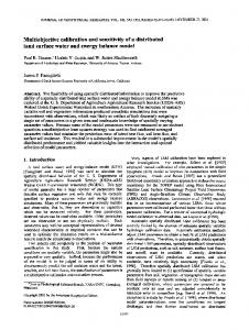
W01538
Table 1. Summary of Hydraulic and Thermal Parameter Ranges Used in the VS2DH Modela Model Zones Parameter Description Saturated horizontal hydraulic conductivity Anisotropy Saturated vertical hydraulic conductivity Porosity Longitudinal dispersivity Transverse dispersivity Volumetric heat capacity Thermal conductivity of saturated sediments
Symbol Kx Kz/Kx Kz � �L �T Cs Kts
Units �1
mh
m h�1 m3 m�3 m m J m�3 � C�1 W m � C�1
Shallow
Low Permeability
0.1–1.0 0.1–1.0 0.01–1.0 0.30 0.5 0.1 1.1–2.5 � 106 0.5–2.7
0.001–0.01 0.1–1.0 1 � 10�4 to 0.01 0.4 0.5 0.1 1.4 � 106 1.5
Deep
Source
0.01–1.0 Calibration 0.01–0.1 Calibration 1 � 10�4 to 0.1 Kz ¼ Kx (Kz/Kx) 0.30 Niswonger and Prudic [2003] 0.5 Niswonger and Prudic [2003] 0.1 Niswonger and Prudic [2003] 1.1–2.5 � 106 Calibration 0.5–2.7 Calibration
a
Parameters in the shallow, low-permeability, and deep zone are noted with prefixes s, lens, and d, respectively.
riffle locations as a result of a lower-permeability deposit between the shallow and deep zones, referred to herein as the low-permeability deposit. This low-permeability deposit could represent a zone of internal colmation [Brunke, 1999] or a fine-grained deposit such as a fragipan [Niswonger and Fogg, 2008]. The deep zone was assumed to be a transition from highly mobile riverbed deposits to compacted sedimentary deposits with finer-grained material deposited in downwelling riffle zones (P2–P8; Figure 1a). [23] Although it was hypothesized that a sharp contrast in the permeability was present, we assumed no difference in the upper bound of hydraulic conductivity for the lowpermeability deposit and the deep zone. That is, the URS method sampled from a range in hydraulic properties for each of the three zones that did not depend on initial assumption regarding the permeability. We specified 2 orders of magnitude range in vertical hydraulic conductivity for the shallow zone and low-permeability zone and 3 orders of magnitude range in the deep zone (Table 1). [24] Root-mean-square error (RMSE) values were calculated for each temperature and pressure observation location, referred to as a local RMSE. By observing the local RMSE, variability in optimal parameters for each observation location can provide information about the scale of heterogeneity and the variance in hydraulic and thermal properties. Accordingly, the implementation of the URS method in this study would allow for testing our hypothesis regarding the three zone conceptualization and would provide additional information on the scale of heterogeneity. [25] One thousand realizations each with different hydraulic and thermal parameters were analyzed, and errors resulting from temperature and pressure estimates were calculated from the root mean square error objective function written as vffiffiffiffiffiffiffiffiffiffiffiffiffiffiffiffiffiffiffiffiffiffiffiffiffiffiffiffiffiffiffiffiffiffiffiffiffiffiffiffiffiffiffiffiffiffiffiffiffi u N u 1 X temp;hp temp;hp 2 RMSE ¼ t ð� ��2 Þ ; N t¼1 1
and errors were assumed to be independent of each other. Plotting the model performance (RMSE) against each parameter provides a means to determine identifiable parameters, referred to herein as a ‘‘RMSE scatterplot.’’ Parameters are identifiable if a distinct minimum in the RMSE is present, whereas unidentifiable parameters exhibit similar RMSE values for a range in the parameter values. In VS2DH, horizontal hydraulic conductivity (Kx) and anisotropy (Kz/Kx) are model inputs, while vertical hydraulic conductivity (Kz) is calculated by taking the product of the two (Table 1). The range used for anisotropy (Table 1), reflects the assumption that Kx is greater than Kz. This assumption was supported by initial simulated results. The model was allowed to ‘‘warm up’’ for 124 h period where simulated values were not used to calculate the objective function. [26] Parameter sensitivity was determined using a global method called regional sensitivity analysis (RSA) [Young, 1978; Hornberger and Spear, 1981; Freer et al., 1996; Wagener et al., 2001]. The method, as modified by Wagener et al. [2001], divides the population of transformed objective functions into 10 groups of equal size, ranked by their performance and plotted against the feasible parameter range. Sensitive parameters are identified by large differences between the cumulative normalized distributions (CND) for each group. If the objective function is insensitive to a particular parameter then the CND will have a relatively small slope over the range of the parameter value, whereas sensitive parameters will have a steep slope [Wagener et al., 2001]. When used together, the scatter and RSA plots provide a means to illustrate the identifiability and evaluation of model parameters and for refinement of parameter ranges and estimation of model uncertainty [Wagener et al., 2001; Wagener and Kollat, 2007].
4. (1)
where N is the total number of observations values, �1 is simulated temperature or pressure, and �2 is observed temperature or pressure. As indicated above, local RMSE was computed for each observation of temperature and pressure independently and a regional overall RMSE was computed by combining all locations of pressure and temperature into a single objective function. For each simulation, the parameters
Results
4.1. Field Observations [27] Two major events, with contrasting river temperatures, occurred during the monitoring period on 20 April 2009 (11 m3 s�1) and 3 May 2009 (46 m3 s�1) that resulted in a doubling and an order-of-magnitude increase in discharge, respectively (Figure 2a). The discharge during the initial monitoring period was relatively constant with an average of 5.5 m3 s�1 and a 2.8� C diel temperature variation (Figure 2a). The discharge event that occurred on 20 April occurred during a period when ambient temperatures
5 of 16
W01538
NARANJO ET AL.: USE OF MULTIOBJECTIVES IN HYPORHEIC EXCHANGE
Figure 2. (a) Truckee River temperature (gray line) and discharge (black line) during the simulation period. Discharge was measured from U.S. Geological Survey gage 10351700, TRUCKEE RV NR NIXON, NV. Vertical temperature envelopes were measured during a 24 h period at low-flow (5.9 m3 s�1 ; 29 March 2009) and high-flow (46.5 m3 s�1 ; 6 May 2009) periods at the nested piezometers located in the (b) riffle and (c) pool locations.
were increasing and relatively warmer discharge from the river infiltrated into a cooler riverbed. The average river temperature was 10� C during the relatively steady flow that occurred between 20 March and 14 April. The river temperatures steadily increased from 5.3� C to 17.1� C from 16 to 20 April. The second discharge event on 3 May resulted in a 3.0� C decrease in river temperature. At this point, the river began to exhibit a diel temperature variation of 2.8� C between 6 and 13 May, with an average river temperature of 10.2� C on 13 May (Figure 2a). During both discharge events, the river temperature was relatively warmer than the riverbed. [28] Temperature envelopes can be used qualitatively to assess the relative amount of river seepage that penetrates into the deeper sediment (>1 m beneath the riverbed). Lapham [1989] showed that for downward seepage rates, seasonal temperature envelopes will be broad several meters beneath a river. Similarly, this concept can be used to look at diel temperature envelopes. Temperature envelopes measured beneath the riffle (upriver) sections of the Truckee River indicate that seepage is impeded above a depth of 1 m with an extinction depth near 0.20 m (Figure 2b). These temperature envelopes combined with the large VHG measured at the shallow and deep piezometers beneath the riffles indicate that there is a low-permeability zone between the shallow and deep observations beneath the riffles that does not extent beneath the pool (Figure 2c). [29] Longitudinal patterns of VHG measured from the top of the riffle to the end of the pool show the deviation from downward vertical flow to upward vertical flow
W01538
typified by riffle-pool conceptual models (Figure 3a). At the head of the riffle, locations P1–P6 were predominantly downwelling with a greater variation in VHG, suggesting a greater sensitivity to changes in stage. In pool locations P10–P15, the gradient is near zero with occasional periods of slightly upward flow (Figure 3a). [30] The VHG determined from nested wells reveal greater detail of the complex flow directions in the riverbed as compared to VHG typically measured between the river and a single piezometer. The VHGs show the change in gradient from downward to neutral or horizontal flow in the NP1–NP4 piezometers located on the head of the riffle (Figure 3b). VHGs calculated using the river water surface and the deepest piezometer water levels are much different than VHGs calculated using the shallow and deep piezometer water levels, illustrating a greater variability in flow directions beneath the riverbed (Figure 3c). In the pool, the vertical gradients measured at NP5–NP7 suggest upward flow (Figure 3d), and significant variability in the VHG with depth (Figure 3e). The variation in flow direction (positive or negative VHG) between each nested piezometer
Figure 3. (a) Vertical hydraulic gradient (VHG) as a function of location and depth (b, d) below the streambed referenced from the streambed and (c, e) between nested piezometers located at head of the riffle and middle of the pool from periodic measurements (8–9 June). The VHG measured across each transect (Figure 3a) show upwelling and downwelling zones as measured from the streambed surface to the screened interval at each piezometer. The VHG measurement between piezometers (Figures 3c and 3e) reflect more complex flow patterns because of smallerscale heterogeneity as compared to gradients averaged from the streambed (Figures 3b and 3d). Positive, zero, or negative VHG suggest the potential flow direction is the upwelling, horizontal, or downwelling direction, respectively. Scale on horizontal axis was modified to emphasize measured values.
6 of 16
W01538
NARANJO ET AL.: USE OF MULTIOBJECTIVES IN HYPORHEIC EXCHANGE
confirms the existence of multidirectional flow patterns and using single depth measurements to infer direction should be used with caution. [31] Hydraulic conductivity estimated from falling head tests (Kslug) of in-river piezometers ranged from 0.003– 2.016 m h�1, with a geometric mean of 0.17 m h�1. At most locations, the head elevations recovered to equilibrium conditions within 5–25 s. Falling head tests were not performed in nested piezometers because of the inability to reliably measure head changes. 4.2. Model Calibration and Sensitivity Analysis [32] Measured temperatures and pressures were used to calibrate VS2DH on the basis of a conceptual model of the riffle-pool hyporheic zone that incorporated three distinct zones with differing hydraulic and thermal properties. The conceptual model was defined by a shallow zone, a lowpermeability zone, and a deep zone (Figure 4). [33] Figure 5 shows the results of the model performance and parameter identifiability on the basis of a regional pressure (PRMSE) and temperature (TRMSE) for all shallow and deep zones given parameters Kx, Kz, and Kts. The optimal value is shown as a diamond in Figure 5, as determined by the lowest RMSE. Unique solutions can be determined visually by evaluating the shape and distribution of the RMSE scatter points at the optimal solution. As stated above, parameters are identifiable if a distinct minimum in the RMSE is present, whereas unidentifiable parameters exhibit similar RMSE values for a range in the parameter values. The optimal values for the horizontal hydraulic conductivity sKz (shallow) and dKz (deep) were not identifiable on the basis of pressure (PRMSE) but a distinct minimum was identified with temperature (TRMSE). The scatterplots for sKz and dKz given PRMSE revealed similar results (not shown). For sKz and dKz (PRMSE), sKts and
W01538
dKts (TRMSE), the values that resulted in the minimum RMSE were near the minimum value in the assigned ranges (Table 1). The sKz, dKz, dKx, parameters were slightly more identifiable than others with a distinct value corresponding to a minimal regional objective function (Figure 5). [34] Figure 6 shows the RSA plots for the same parameters, where the optimal performing group is shown by the black line. The parameter population is split into 10 groups of equal size and the cumulative distribution of the parameters in each group is plotted. As shown by the slope of the CND for each bin, the sensitivity the parameter depends on its location in the solution space (i.e., the values of other variable parameters in a simulation). The sensitivity of sKz and dKz is considerably higher near the minimum range of the parameters, as defined by values of PRMSE. However, the sensitivity of sKts is high over the complete range of the parameter values, as defined by values of TRMSE. Overall, there are similarities between the identifiability determined by the RMSE scatterplots in Figure 5 and the sensitivity determined by visualization the RSA plots. [35] Evaluation of model performance on the basis of measured temperatures in the shallow and deep riffle and pool locations are shown in Figures 7 and 8. For brevity, only parameters Kx and Kz are shown. The differences between the individual location (local) RMSE values and the overall RMSE values are illustrated by the solid circle and the open diamond, respectively. At P10 (screened at a depth of 20 cm), the local optimal value of sKx was identifiable (0.24 m h�1), but different than the value determined by the overall TRMSE (1.0 m h�1). However, the Kx was less identifiable in the shallow than the deep zone. At other shallow locations (i.e., P2, P12, and P15), the sKx was different, but not significantly different between the local and overall RMSE. At all deep locations, the parameters dKx and dKz are identifiable on the basis of TRMSE but not
Figure 4. Location of model layers, grid, boundaries, and observations for the VS2DH model. Grid dimensions are 3.0 � 0.10 m, and domain is 160 m in length. Drawing is scaled 1:20, and flow direction is from east to west. P is the pressure (m), T is temperature (� C), and x and z are distance (m) along the horizontal and vertical dimensions, respectively. 7 of 16
W01538
NARANJO ET AL.: USE OF MULTIOBJECTIVES IN HYPORHEIC EXCHANGE
W01538
Figure 5. Scatterplots showing parameter identifiability for the (a) shallow and (b) deep zones predicted by a regional overall root-mean-square error (RMSE) for pressure (PRMSE) and temperature (TRMSE). Each scatter point correspond to 1 of 1000 VS2DH simulations. The diamond corresponds to the optimal value identified by the lowest RMSE. Parameter values near the origin reflect parameter values estimated at the minimum of the parameter range. Horizontal hydraulic conductivity (Kx), vertical hydraulic conductivity (Kz), and thermal conductivity (Kts) are shown for the shallow and deep zones, denoted by prefixes s and d, respectively. identifiable on the basis of PRMSE. As shown in Figure 5, the vertical and horizontal hydraulic conductivity determined by PRMSE was not identifiable within the range of values initially assigned.
[36] Table 2 summarizes the hydraulic and thermal parameters for each observation estimated on the basis of the local RMSE values. The hydraulic conductivity values estimated by slug tests (Kslug) were in general agreement with values
Figure 6. The regional sensitivity analysis plots showing the sensitivity of model parameters plotted across the feasible parameter range for the (a) shallow and (b) deep zones. The parameters are ranked according to the objective function, divided into 10 bins of equal size, and normalized so each bin sums to unity, and the cumulative distribution for each bin is plotted versus the parameter value. The black line corresponds to the bin of the parameters with the best performing model simulations. Parameter sensitivity can be assessed by the spread between each of the 10 bins and the slope of the distribution. Higher spread in each of the bins and a steep slope correspond to higher sensitivity. Horizontal hydraulic conductivity (Kx), vertical hydraulic conductivity (Kz), and thermal conductivity (Kts) are shown for the shallow and deep zones, denoted by prefixes s and d, respectively. 8 of 16
W01538
NARANJO ET AL.: USE OF MULTIOBJECTIVES IN HYPORHEIC EXCHANGE
Figure 7. Scatterplots of model performance at the (a) riffle (P2–P8) and (b) pool (P10–P15) locations in the shallow zone. Each scatter point corresponds to 1 of 1000 VS2DH simulations. The solid circle corresponds to the parameter value with the lowest local RMSE, whereas the diamond corresponds to the parameter value given the regional RMSE. Parameter values near the origin reflect parameter values estimated at the minimum of the parameter range. (top) Shallow horizontal hydraulic conductivity (sKx) and (middle) vertical hydraulic conductivity (sKz) determined by temperature RMSE (TRMSE), respectively. (bottom) The shallow vertical hydraulic conductivity (sKz) determined by pressure RMSE (PRMSE) shown for comparison to TRMSE in Figure 7 (middle).
Figure 8. Scatterplots of model performance at (a) riffle (P2–P8) and (b) pool locations (P10–15) in the deep zone. Each scatter point corresponds to 1 of 1000 VS2DH simulations. The solid circle corresponds to the parameter value with the lowest local RMSE, whereas the diamond corresponds to the parameter value given the regional RMSE. Parameter values near zero reflect parameter values estimated at the minimum of the parameter range. (top) Deep horizontal hydraulic conductivity (dKx) and (middle) vertical hydraulic conductivity (dKz) determined by temperature RMSE (TRMSE). (bottom) Deep vertical hydraulic conductivity (dKz) determined by pressure RMSE (PRMSE), shown for comparison to TRMSE in Figure 8 (middle). 9 of 16
W01538
NARANJO ET AL.: USE OF MULTIOBJECTIVES IN HYPORHEIC EXCHANGE
W01538
W01538
Table 2. Thermal and Hydraulic Parameters Derived From the VS2DH Model for Each Location Along the Riffle-Pool Sequence Based on Local TRMSEa Location P2 P5 P8 P10 P12 P15
Kslug (m h�1)
sKts (W m�1 � C�1)
sCs (J m�1 � C�1)
sKx (m h�1)
sKz (m h�1)
dKts (W m�1 � C�1)
dCs (J m�1 � C�1)
dKx (m h�1)
dKz (m h�1)
0.097 1.854 0.272 0.310 0.003 0.468
0.90 0.50 1.52 0.51 0.55 0.50
1.2 � 106 1.3 � 106 1.2 � 106 1.3 � 106 1.3 � 106 1.3 � 106
0.70 0.99 0.98 0.29 0.83 0.83
0.19 0.10 0.51 0.03 0.08 0.08
1.38 2.68 1.55 2.42 2.44 0.86
2.4 � 106 2.0 � 106 2.3 � 106 1.2 � 106 2.5 � 106 2.0 � 106
0.98 0.37 0.25 0.26 0.07 0.45
0.05 0.04 0.01 0.02 0.01 0.01
a Prefixes s and d represent shallow and deep locations, respectively. Subscripts x and z represent horizontal and vertical discretization, respectively. Hydraulic conductivity was estimated by slug test (Kslug). TRMSE, root-mean-square error for temperature.
estimated using the RSA approach at the deep locations (i.e., P8, P10, and P15). The thermal conductivity (Kts) was lower overall in the shallow zone (0.50 to 1.52 W m�2 � C�1) than in the deep zone (0.86 to 2.68 W m�2 � C�1). The heat capacity (Cs) was greater in the deeper zone than in the shallow zone. 4.3. Simulated Temperature and Pressure [37] The URS method provides a means of identifying the optimal set of parameters according to the overall RMSE value. Additionally, the top 5% of solutions (i.e., parameter sets that result in the lowest 5% RMSE values) provides a means of evaluating the uncertainty of model simulations. Figure 9 shows the observed and simulated temperatures for shallow and deep locations. Overall, there is close agreement between observed and simulated temperatures for the top 5% RMSE solutions; with approximately 1.0� C bias at locations P5 20 cm and P8 20 cm. The model tends to over estimate the diel oscillations at shallow pool location P15 20 cm, suggesting there is heterogeneity at this location that is not included in the model. However, inclusion of additional heterogeneity likely would result
in less identifiable parameters, which expresses the subtle balance between accuracy and uniqueness. The model captures the long-term thermal signal in the deep observations. Figure 10 shows the observed and simulated pressures. The model simulated a greater variation of pressures in the riffle locations than in the pools because of the low-permeability zone between the shallow and deeper zones. Generally, the observed pressure behavior mimicked the behavior of the river stage. The model captured the thermal and pressure behavior indicated by the agreement between the observed and simulated results (Figures 9 and 10). 4.4. Simulated Flux Rates and Flow Paths [38] Figure 11 shows the simulated vertical flux rates in the riffle and pool locations. Negative flux in the vertical direction (qz) represents flow in the upward direction. For brevity, only the vertical flux rates are shown. The simulated flux in the shallow locations P8 20 cm and P12 30 cm are in the upward direction. The other locations are predominantly in the downward direction. The first flow event (20 April) and second flow (3 May) event occurred during simulation times 600 and 920 hours, respectively. The
Figure 9. Observed (black line) and simulated streambed temperatures showing all realizations (dark gray shading) and the ‘‘best’’ 5% (light gray shading) based on overall RMSE at the (a) riffle (P2–P8) and (b) pool (P10–P15) (top) shallow and (bottom) deep zone locations. The simulation period is from 20 March 2009, 13:00 LT, to 15 May 09, 15:00 LT. The first flow event (20 April) and second flow event (3 May) occurred during simulation times 600 and 920 hours, respectively. 10 of 16
W01538
NARANJO ET AL.: USE OF MULTIOBJECTIVES IN HYPORHEIC EXCHANGE
Figure 10. Observed (black line) and simulated head pressure showing all realizations (dark gray shading) and best 5% (light gray shading) based on the overall RMSE for the (a) riffle and (b) pool locations. The greater variation in simulated pressure at the riffle locations is due to the uniform random search method applied to the lowpermeability zone that does not extend into the pools. The simulation period is from 20 March 2009, 13:00 LT, to 15 May 2009, 15:00 LT. Pressure was measured near the screened interval within the deep zone. The first flow event (20 April) and second flow event (3 May) occurred during simulation times 600 and 920 hours, respectively. response of each event on the vertical flux was variable depending on location and direction of flux. Generally, the increase in river flow resulted in increases in vertical flux through the riverbed surface. The simulated flux at location
W01538
P10 (shallow and deep) exhibited a slight flow decrease or suppression of upward flow because of the increased stage in the river. [39] Figure 12a shows the simulated vertical flux across the riverbed interface for both low flow (29 March) and high flow (6 May). The effect of the low-permeability zone in the riffle area can be seen by the lower estimated vertical downward flux (1.0 � 10�4 to 3.0 � 10�4 m h�1). Most of the exchange in both the upward and downward direction occurs where the low-permeability zone becomes discontinuous, just upriver of the pools. The 6 May flow event (flow increased from 5.9 to 46.5 m3 s�1) increased the vertical upward flux just downriver of P10 by an order of magnitude (flux increased from 9.0 � 10�4 to 4.2 � 10�3 m h�1). At an adjacent downward flow path (near P12), the flux increased from 1.0 � 10�3 to 3.9 � 10�3 m h�1 because of the 6 May flow event (Figure 12a). [40] Figure 12b shows the simulated temperatures and idealized flow patterns for the flow event that occurred on 6 May. The steep thermal gradient and horizontal seepage caused by the low-permeability zone is clearly identified in the shallow riffle section of the study area (P2–P8). The areas with the greatest exchange with the river occur at short flow paths at the transition from lower riffle to pool near P8. Downward seepage at the upper section of the riffle near P2 is predominantly downward and horizontal. In the pool, there is greater exchange with the river because of relatively short flow paths (Figure 12b). Smaller-scale flow paths in the pool area appear to have the greatest exchange with the river in low- and high-flow conditions. Table 3 summarizes the average horizontal and vertical flux rates. [41] Using temperature and pressure observations to constrain the parameter estimation process provides the lowest overall RMSE as compared to using temperature or pressure observations alone. Table 4 summarizes the ‘‘best’’ parameter values resulting from the single objective function
Figure 11. Simulated vertical and horizontal flux at the (a) riffle and (b) pool locations for the (top) shallow and (bottom) deep zones. All realizations (dark gray shading) and best 5% (light gray shading) and 2.5% (green shading) are based on the overall RMSE. Negative flux in the vertical direction represents flow in the upward direction. The simulation period is from 20 March 2009, 13:00 LT, to 15 May 2009, 15:00 LT. The first flow event (20 April) and second flow event (3 May) occurred during simulation times 06:00 and 09:20 LT, respectively. 11 of 16
NARANJO ET AL.: USE OF MULTIOBJECTIVES IN HYPORHEIC EXCHANGE
W01538
W01538
Figure 12. (a) Vertical flux across the streambed interface at low flow (5.9 m3 s�1 ; 29 March 2009, 13:00 LT) and high flow (46.5 m3 s�1 ; 6 May 2009, 09:15 LT) showing the effect of the low-permeability deposit, streambed slope, and flow path direction on magnitude of exchange. (b) Simulated streambed temperatures, idealized flow paths (gray lines), observations (red diamonds), and velocity vectors during the peak discharge of 46.5 m3 s�1 and temperature of 14.4� C on 6 May 2009. Deep flow path (labeled A), shallow horizontal flow path (B), and short upwelling flow path (C) in the riffle and pool section are in a predominantly losing system. The dashed line represents the boundary between upper and lower deposits.
measure for temperature (TRMSE) and pressure (PRMSE) and combined RMSE. The horizontal and vertical hydraulic conductivity estimated by temperature and combined temperature and pressure are very similar where as the parameters estimated from pressure alone can be an order of magnitude lower (sKz, dKz, lens Kz). For the single objective function (TRMSE and PRMSE), the vertical hydraulic conductivity for the upper (sKz), low-permeability (lens Kz), and deep (dKz) zones is 0.22, 0.0019, and 0.018 m h�1, respectively. Given a single objective function, the parameters set provided by the temperature was in close approximation to the combined pressure and temperature objective function.
Table 3. Average Horizontal and Vertical Fluxes at the Riffle and Pool Locationsa Location
sqx (m h�1)
sqz (m h�1)
dqx (m h�1)
dqz (m h�1)
P2 P5 P8 P10 P12 P15
4.9 � 10�3 3.9 � 10�3 1.3 � 10�2 5.6 � 10�3 1.8 � 10�2 1.1 � 10�2
�3.0 � 10�3 �2.9 � 10�3 1.2 � 10�2 �3.3 � 10�3 3.1 � 10�3 �7.3 � 10�3
2.1 � 10�3 8.2 � 10�3 6.5 � 10�3 9.5 � 10�3 2.8 � 10�3 7.2 � 10�2
�1.3 � 10�3 �5.2 � 10�3 �1.3 � 10�4 �1.9 � 10�3 �1.9 � 10�4 �1.0 � 10�3
a Prefixes s and d represent shallow and deep locations, respectively. Subscripts x and z represent horizontal and vertical discretization, respectively. Negative values of sqz correspond to the downwelling direction.
5.
Discussion
[42] The VHG can vary significantly when compared to vertically integrated measurements. Measurements at the fine scale (