P2.11
THE WRF-SINGLE-MOMENT-MICROPHYSICS SCHEME
AND ITS EVALUATION OF THE SIMULATION OF MESOSCALE CONVECTIVE SYSTEMS Jeong-Ock Jade Lim, Song-You Hong*, and Jimy Dudhia** Department of Atmospheric Sciences, Yonsei University, Seoul, Korea **National Center for Atmospheric Research, Boulder, Colorado
1.
INTRODUCTION
A bulk parameterization of cloud particles and precipitation drops that is primarily based on the works of Lin et al. (1983) and Rutledge and Hobbs (1983) has been a core part in representing cloud and precipitation processes in both General Circulation Models and mesoscale models. For the last two decades, they have been successfully applied to the simulation of convective systems. On the other hand, some problems has been reported, for example, producing too much ice crystals in the upper troposphere. Recently, Hong et al. (2003, HDC hereafter) has suggested a revised approach to ice-microphysical processes in order to overcome the deficiencies identified by previous studies (Table 1). Several modifications are introduced to more realistically simulate some of the ice-microphysical processes. In addition to the assumption that ice nuclei number concentration is a function of temperature, a new and separate assumption is developed in which ice crystal number concentration is a function of ice amount. Related changes in ice microphysics are introduced, and the impact of sedimentation of ice crystals is also investigated. HDC implemented the revised ice-microphysics into the WRF model, and its performance was evaluated. Thus it is called as the WRF-SingleMoment-Microphysics scheme (WSMMPs). They concluded that together with the sedimentation of cloud ice, the new microphysics reveals a significant improvement in high-cloud amount, surface precipitation, and large-scale mean temperature through a better representation of the icecloud/radiation feedback. This study further examines the performance of the WRF-Single-Moment-Microphysics scheme (Hong et al., 2003). Tests of the new scheme in HDC for a heavy rain event is limited in a sense that the precipitation in the selected case is associated with a synoptically organized cyclone developed in East Asia on 24-25 June 1997. Also, a 45-km resolution is too coarse to resolve mesoscale features. To this end, a band type of heavy precipitation over Korea on 14-15 July 2001 and the other mesoscale convective system developed in the Central Great Plains of
United States on 15 June 2002 are examined. In addition to simple and mixed phase schemes in HDC, a more complex scheme with the inclusion of graupel substance being another prognostic variable is developed. The performance of the scheme will be examined against the Purdue Lin scheme (Chen and Sun, 2002) in the WRF model. Table 1. Major components of the Ice microphysics processes suggested by Hong et al. (2003) component Number concentration of cloud ice
Formula
N I = c ( ρ qI )
d
Ice nuclei number
N I 0 = 103 exp[0.1(T0 − T )]
Sedimentation of cloud ice
VI (ms −1 ) = 1.49 × 10⁴ D1.31
Intercept parameter for snow
N 0 S ( m −4 ) = 2 × 10⁶ exp{0.12(T0 − T )}
2.
SELECTED CASES
A significant amount of precipitation was recorded just south of the border between the North and South Korea on 15 July 2001 (Fig. 1a). A local maximum in the central part of Korean peninsula (Seoul) was about 371.5 mm. The mesoscale convective system was embedded within the East-Asian summer monsoon frontal system. The south western part of South Korea received a moderate rain less than 100 mm. Most of rainfall was observed during the 12-hr period of 1200 UTC 14 - 0000 UTC 15 July 2001, and maximum rain rate was 99.5 mmh-1 between 1700 UTC and 1800 UTC 15 July 2001. During the heavy precipitation over the Korean peninsula, high-pressure systems located on the north of Korea prevented a monsoon front from moving northward, thus the monsoon front was tied up over Korea region (not shown). In association with this frontal system, a southerly low level jet (LLJ) brought moisture northward to stationary monsoon front, which resulted in flooding in Seoul.
* Corresponding author address: Song-You Hong, Yonsei University, Dept. of Atmospheric Sciences, Seoul, Korea; e-mail:
[email protected]
The Second case is mesoscale convective system developed in the Central Great Plains of
(a)
(b)
Table 2. A summary of microphysics schemes used in the numerical experiments in this study.
3 species (qv, qci, qrs)
Fig. 1. The observed 24-h accumulated precipitation (mm) (a) over Korea valid at 0000 UTC 15 July 2001 and (b) over the central Great Plains in US at 1200 UTC 16 June 2002.
United States on 15 June 2002 (Fig. 1b), whose squall line moved southward through Oklahoma to the central Texas, after initially developing north of Oklahoma. The heavy rainfall over Korea (Fig. 1a) and over US (Fig. 1b) are named as the Case 1 and Case 2, respectively, in this study. Case2 is a mesoscale convective system associated with a fast moving squall line observed during the period of the International H2O Project (IHOP) in June 2002, whereas heavy rainfall in the Case 1 is related to a synoptically well organized and nearly stagnant frontal system during the East Asian summer monsoon.
3.
NUMERICAL EXPERIMENTS
The WRF model is used in this study. The model is run at a 45 km grid spacing for Case1 and a 4 km for Case2 on a Lambert-conformal conic projection with 23 levels in the vertical. The number of horizontal grid points in both x- and y- directions is 80×80 for Case1 and 300×270 for Case 2 centered at 36N, 98W for Case1 and 37N, 127.5E for Case 2. The Kain-Fritsch cumulus parameterization scheme (Kain and Fritsch 1993) is selected to account for sub-grid scale precipitation physics for Case1. This process is not considered for Case2 because of high resolution in the horizontal. A nonlocal vertical diffusion scheme is used to calculate the vertical fluxes of sensible heat, latent heat, and momentum (Hong and Pan 1996). A simple short wave radiation scheme is used (Dudhia 1989), and a multi-band long wave radiation package is selected (Mlawer et al. 1997). Experiments are set up in the way of comparing WSMMPs with the existing parameterization schemes (Table2). The numbers at the end of WSM, that is, 3, 5 and 6 mean the number of categories of hydrometeor predicted including the water vapor.
Old parameterization
New parameterization
NCEP3
WSM3
(Hong et al. 1998) (Hong et al. 2003)
5 species (qc, qi, qr, qs)
NCEP5 (Hong et al. 1998)
WSM5 (Hong et al. 2003)
6 species (qv, qc, qi, qr, qs, qg)`
PLIN (Purdue lin, Chen and Sun2002)
WSM6 (Hong et al. 2003)
4.
RESULTS
Since WSM3 and WSM5 experiments shows similar sensitivity discussion will mainly be focused on WSM5.
4.1.
Case1 (14-15 July 2001)
Overall all simple and mixed phase experiments capture the long banded feature of the observed heavy rainfall extending from southwest to northeast across the center part of the Korean peninsula, but the maximum amount is underestimated (Figs. 2a and 2b). The observed maximum precipitation is 371.5 mm whereas the WSM5, NCEP5, the WSM6 and PLIN experiments produce 140 mm, 140 mm, 150 mm and 180 mm, respectively. A more intensive rainfall from the WSM3 and WSM5 experiments than those from the NCEP3 and NCEP5 experiments is distinct (Figs. 2c and 2d), indicating that the revised microphysics in HDC after the Dudhia (1989) and Rutledge and Hobbs (1983) makes the rain band
(a)
(c)
(b)
(d)
Fig. 2. 24-hr accumulated rainfall (mm) ending at 0000 UTC 15 July 2001 from the (a) WSM3 and (b) WSM5 experiments, and the differences between (c) WSM3 and NCEP3 and (d) WSM5 and NCEP5.
(a)
4.2.
(b)
Case 2 (15-16 June 2002)
In general, all experiments successfully simulate the 24-h accumulated precipitation in association with the movement of a squall line southward. The distribution of precipitation pattern covering Kansas, Oklahoma, and northern Texas is well reproduced (a)
(d)
(b)
(e)
(c)
(f)
Fig. 3. 24-hr accumulated rainfall (mm) ending at 0000 UTC 15 July 2001 from the (a) WSM6 and (b) PLIN experiments. closer to what was observed. Experiments with the graupel species (WSM6 and PLIN) also well simulate the rain band in terms of its overall pattern, but too much rainfall in the PLIN experiment (Fig. 3). It can be seen that WSM6 reproduces rain band similar to WSM3 and WSM5, but the distribution of accumulated rainfall becomes narrower and shows locally intensified feature. (b)
(a)
0℃
(c)
0℃
-3
water content (gm )
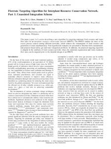
Fig. 4. Vertical distributions of area averaged (33N41N, 123E-131E) water species at 1800 UTC 14 July 2001 from (a) WSM5, (b) NCEP5, (c) TRMM observation (Del Genio and Kovari 2002). Solid line is for rain, dotted line for snow, dashed line for cloud water and dot-dashed line for cloud ice.
Figures 4a and 4b compare the vertical profiles of condensate and precipitation mixing ratios averaged over heavy rain region centered over Korea from WSM5 and NCEP5, respectively. Fig. 4c is a TRMM observation from Del Genio and Kovari (2002). This profile is just a reference profile for corresponding species since the retrieved profiles from the Del Genio and Kovari depends upon the cloud model used in the retrieval processes. Nevertheless, it is evident that the WSM5 experiment produces more realistic profiles, which qualitatively agree with that of TRMM observation than the NCEP5 does due to new ice microphysical process, especially number concentration of ice nuclei which is a function of temperature (Fletcher, 1962) in the NCEP5, which leads to the absence of cloud ice between 400 – 500 mb, as discussed in HDC.
Fig. 5. 24-hr accumulated rainfall precipitation valid at 1200 UTC 16 June 2002 (mm) ending at 0000 UTC 15 July 2001 from the (a) WSM3, (b) WSM5, (c) WSM6, (d) NCEP3, (e) NCEP5 and (f) PLIN experiments.
irrespective of the choice of the microphysics scheme, but precipitation intensity varies from one scheme to another (Fig. 5). As in the Case 1, it is evident that the precipitation with the WSM3 and WSM5 experiments produce more intense rainfall than NCEP3 and NCEP5. It is also clear that the WSMMP schemes produce a similar pattern whereas the existing schemes show more variable results. The PLIN experiment produces the maximum intensity, and the NCEP5 results in the minimum. The results from the WSM6 are similar to PLIN but shows less intense rainfall than that from the PLIN experiment. It can be seen in the comparison of the time series of simulated precipitation that the WSM6 reduces the precipitation significantly (Fig. 6).
As in the case of Case1, the result of WSM6 are similar to those from the WSM3 and WSM5 in terms of overall pattern, but the rainfall amount becomes larger and rain distribution becomes narrower as the number of hydrometeors species is increased. This is because the graupel’s higher fall speed leads to more intense local rainfall than other schemes that has snow as its onlyy precipitating ice category.
PLIN scheme in the WRF model has shown a good performance in terms of the simulation of precipitation pattern, but with systematically overestimated nature, as pointed out by Weisman et al. (2003) and also in the verification results in the WRF web site (http://wrf-model.org), the new graupel scheme (WSM6) is promising to improve the forecasts of precipitation by alleviating the high precipitation bias in the WRF model.
6.
ACKNOWLEDGEMENT
This study is supported by the Ministry of Science and Technology through National Research Laboratory Program.
7. WSM6 PLIN
Fig. 6. The time series of simulated precipitation averaged over domain where solid line is for WSM6 and dashed line for PLIN.
5.
CONCLUDIONS
This study examines the performance of the WSMMPs (Hong et al. 2003) for the heavy rainfall events occurring on 14-15 July 2001 over Korea and in the Central Great Plains of United States on 15 June 2002. The WSMMP microphysics scheme enhances the rainfall amount against the existing cloud schemes (eg. Dudhia 1989, Reisner et al. 1989 etc.), and the WSMMP microphysics alleviates the discontinuity of vertical distribution of cloud ice ,which is more realistic. The results with the inclusion of graupel substance (WSM6) are similar to those from the simple (WSM3) and mixed phase (WSM5) microphysics for both synoptic-forcing-dominant case and convection-dominant case, but the rainfall amount becomes larger and rain distribution becomes narrower as the number of classification of hydrometeors is increased. This is because the graupel’s higher fall speed leads to more intense local rainfall than other schemes that has snow with a smaller terminal velocity than the graupel. More efficient conversion of small ice crystals to larger precipitation drops by graupel also contributes the enhanced precipitation in the WSM6. In comparison of the graupel schemes (WSM6 vs. PLIN), both produce similar pattern in terms of distribution of precipitation and banded shape, but rainfall amount is reduced. Bearing in mind that the
REFERENCES
Chen, S.-J., D.-K. Lee, Z.-Y. Tao, and Y.-H. Kuo, 1999: Mesoscale convective system over the Yellow Sea-A numerical case study. Meteor. Atmos. Phys., 70, 185-199. Del Genio, Anthony D., William Kovari, 2002: Climatic Properties of Tropical Precipitating Convection under Varying Environmental Conditions. Journal of Climate: Vol. 15, No. 18, pp. 2597–2615. Fletcher, N. H., 1962: The physics of rain clouds. Cambridge Univ. Press, 390pp. Hong, S-.Y., J. Dudhia, S.-H. Chen, 2003: A revised approach to ice-microphysical processes for the bulk parameterization of cloud and precipitation., Mon. Wea. Rev., in press. Hong, S.-Y., H.-M. H. Juang, and Q. Zhao, 1998: Implementation of prognostic cloud scheme for a regional spectral model, Mon. Wea. Rev., 126, 2621-2639. Hong, S.-Y., and H.-L. Pan, 1996: Nonlocal boundary layer vertical diffusion in a medium-range forecast model. Mon. Wea. Rev., 124, 2322-2339. Kain, J., and M. Fritsch,1993 : Convective parameterization for mesoscale models : The KainFritsch scheme. The representation of cumulus convection in numerical models, Meteor. Mono., 24, Amer. Meteor. Soc., 165-170. Lee, D.-K., H.R. Kim, and S.Y. Hong, 1998: Heavy rainfall over Korea during 1980-1990. Korean J. Atmos. Sci., 1, 32-50 Mlawer, E. J., S. J. Taubman, P. D. Brown, M. J. Iacono, and S. A.Clough, 1997: Radiative transfer for inhomogeneous atmosphere: RRTM, a validated correlated-k model for the long wave. J. Geophys. Res., 102(D14), 16663-16682. Reisner, J., R. M. Rasmussen, and R. T. Bruintjes, 1998: Explicit forecasting of supercooled liquid water in winter storms using the MM5 mesoscale model. Quart. J. Roy. Metero. Soc., 124 B, 10711107. Zhang, D.-L., K. Gao, and D. B. Parsons, 1989: Numerical simulation of an intense squall line during 10–11 June 1985 PRE-STORM. Part I: Model verification. Mon. Wea. Rev., 117, 960–994.