ERDC/CRREL TR-01-15
US Army Corps of Engineers® Engineer Research and Development Center
Sampling for Explosives Residues at Fort Greely, Alaska Reconnaissance Visit July 2000
Cold Regions Research and Engineering Laboratory
Marianne E. Walsh, Charles M. Collins, Charles H. Racine, Thomas F. Jenkins, Arthur B. Gelvin, and Thomas A. Ranney
Approved for public release; distribution is unlimited.
November 2001
Abstract: Impact areas are lands used by the army for ordnance testing and training. The impact areas of Fort Greely, Alaska, are located on lands withdrawn from the public domain under the Military Lands Withdrawal Act (PL 106-65). The Army has pledged to implement a program to identify possible munitions contamination and evaluate the potential for surface water and groundwater contamination. Because of the large size (85,042 acres) of the impact areas, characterization of the contamination levels will be difficult. We have begun a multiphase sampling program at one impact area by first sampling locations that are likely to be contaminated and to identify locations that have the greatest potential to contaminate adjacent surface and groundwater. Based on a review of records at the Fort Greely Range Control and consultation with the Cold Regions Test Center (CRTC), we chose to sample the Washington Impact Area. We focused our sampling on surface soils and collected both composite (multi-increment) and discrete samples at locations of known firing events and from areas on the range that had evidence of range use. Evidence included cratering, pieces of munitions, or a designation as a firing point. Firing events included tests of 81-mm mortars, Tube-launched Optically tracked Wire-guided (TOW) missiles, 40-mm high-explosive cartridges, and
Sense and Destroy Armor (SADARM). We detected explosives residue in 48% of the 107 soil samples we collected. RDX was the most frequently detected explosive (39%). Of the samples above the detection limit, median RDX concentration was only 0.021 µg/g. Loworder detonations accounted for four of the five highest RDX concentrations. TNT was the second most frequently detected explosive (21%). Median TNT concentration in samples where TNT was detected was only 0.004 µg/g. Low-order detonations produced the highest TNT concentration we found. The amino-dinitrotoluene transformation products of TNT were detected in about 10% of the samples. HMX was found in 11% of the samples. The analytes 2,4-DNT and NG were detected at a firing point and in a few samples on the Washington Impact Area. High-explosive projectiles that function properly appear to leave little residue in the surface soil. Low-order detonations, where only part of the high-explosive filler detonated leaving solid explosive composition in contact with surface soil, produced the highest soil concentrations observed. Also, firing points are sources of NG and 2,4-DNT. The greatest potential threat of contamination of surface and groundwater would be high numbers of low-order detonations or heavily used firing points located in groundwater recharge areas.
COVER: Washington Impact Area looking southwest with the Alaska Range in background.
How to get copies of ERDC technical publications: Department of Defense personnel and contractors may order reports through the Defense Technical Information Center: DTIC-BR SUITE 0944 8725 JOHN J KINGMAN RD FT BELVOIR VA 22060-6218 Telephone (800) 225-3842 E-mail
[email protected] [email protected] http://www.dtic.mil/ WWW All others may order reports through the National Technical Information Service: NTIS 5285 PORT ROYAL RD SPRINGFIELD VA 22161 Telephone (703) 487-4650 (703) 487-4639 (TDD for the hearing-impaired) E-mail
[email protected] http://www.ntis.gov/index.html WWW For information on all aspects of the Engineer Research and Development Center, visit our World Wide Web site: http://www.erdc.usace.army.mil
Technical Report ERDC/CRREL TR-01-15 US Army Corps of Engineers® Engineer Research and Development Center
Sampling for Explosives Residues at Fort Greely, Alaska Reconnaissance Visit July 2000 Marianne E. Walsh, Charles M. Collins, Charles H. Racine, Thomas F. Jenkins, Arthur B. Gelvin, and Thomas A. Ranney
Prepared for
U.S. ARMY ALASKA Approved for public release; distribution is unlimited.
November 2001
PREFACE This report was prepared by Marianne E. Walsh, Chemical Engineer, Environmental Sciences Branch, U.S. Army Cold Regions Research and Engineering Laboratory (CRREL), Engineer Research and Development Center (ERDC), Hanover, New Hampshire; Charles M. Collins, Research Physical Scientist, Environmental Sciences Branch, CRREL; Dr. Charles H. Racine, Ecologist, Environmental Sciences Branch, CRREL; Dr. Thomas F. Jenkins, Research Chemist, Environmental Sciences Branch, CRREL; Arthur B. Gelvin, Engineering Technician, Engineering Resources Branch, CRREL; and Thomas A. Ranney, Staff Scientist, Science and Technology Corporation, Hanover, New Hampshire. The authors gratefully acknowledge Alan Hewitt and Dr. Clarence L. Grant for technical review and Gioia Cattabriga for technical editing. Funding for this work was provided by U.S. Army Alaska, under the sponsorship of Douglas Johnson, Chief, Environmental Resources Department. Carrie Barta, NEPA Coordinator, Fort Wainwright, and Ellen Clark, DTA ITAM/Conservation Coordinator, Fort Greely, provided logistical support for our work. Craig Sharp, Range Control Officer, Fort Greely, provided advice and guidance, as well as coordinated access to the ranges. Jim Storey, Test Officer, Cold Regions Test Center, Fort Greely, provided us with invaluable information on various munition tests conducted by CRTC at Fort Greely. He also spent time with us in the field identifying test sites. Sherry Butters, UXO technician, Clearwater Environmental, Inc., provided UXO avoidance services to the field party sampling in the impact areas. Karen Myers from The Environmental Lab, Vicksburg, Mississippi, provided soil analysis for metals. This publication reflects the personal views of the authors and does not suggest or reflect the policy, practices, programs, or doctrine of the U.S. Army or Government of the United States. The contents of this report are not to be used for advertising or promotional purposes. Citation of brand names does not constitute an official endorsement or approval of the use of such commercial products.
ii
to contents
CONTENTS Preface ............................................................................................................................. Nomenclature .................................................................................................................. Introduction ..................................................................................................................... Background .............................................................................................................. Environmental setting .............................................................................................. Range use ................................................................................................................. Munitions ................................................................................................................. Objective of sampling .............................................................................................. Methods ........................................................................................................................... Analytical methods .......................................................................................................... Explosives ................................................................................................................ White phosphorus .................................................................................................... Metals ...................................................................................................................... Results ............................................................................................................................. Known events .......................................................................................................... Other events ............................................................................................................. Discussion ........................................................................................................................ Explosives residues ................................................................................................. Metals ...................................................................................................................... Comparison with current cleanup guidance ............................................................ Recommendations for future sampling plans .......................................................... Conclusions ..................................................................................................................... Literature cited ................................................................................................................. Appendix A: Chemicals ................................................................................................... Abstract ............................................................................................................................
ii v 1 1 2 6 6 6 6 7 7 8 8 8 8 19 27 27 27 31 32 33 34 37 43
ILLUSTRATIONS Figures 1. Washington Impact Area ................................................................................... 2. Typical soil substrate and vegetation in 81-mm mortar fuse test location ........ 3. Sampling grids ................................................................................................... 4. Chromatogram from the extract of surface soil collected in an area with no mortar projectile fins .......................................................................... 5. Chromatogram from the extract of surface soil collected under the low-order detonation of an 81-mm mortar projectile ...................................... 6. Tank used as a target during TOW missile tests ................................................ 7. Chromatograms from the extracts of surface soil collected adjacent to targets used in TOW missile tests ................................................................ 8. Revetment that concealed one of the tank targets used in SADARM tests ....... 9. Impact berm for 40-mm grenade test ................................................................ 10. Firing point for 40-mm grenade test .................................................................. 11. Chromatogram of solvent extract of surface soil collected 1 m up from berm base ......................................................................................................... 12. Cartridge case and ogive of a 40-mm grenade that contained residues of RDX, HMX, and NG .................................................................................. 13. Chromatogram of solvent extract of empty 40-mm cartridge case found along firing point ............................................................................................. iii
2 4 5 9 11 12 14 15 17 18 18 20 20
14. Range maintenance crater located near mortar test area ................................... 15. Chromatogram of solvent extract of soil collected 10 m from center of range maintenance crater ............................................................................. 16. Sampling soil at Lampkin Range firing point ................................................... 17. Chromatogram of solvent extract of soil collected at Lampkin Range firing point ....................................................................................................... 18. Grenades found scattered on a gravel pad on the Washington Impact Area ..... 19. Chromatogram of solvent extract of soil collected on a gravel pad that had pieces of 2.75-in. low-spin folding fin aircraft rockets and grenades scattered over the surface ................................................................. 20. Using the Expray kit to identify the explosive filler of a 2.75-in. rocket warhead as Composition B .............................................................................. 21. Chromatogram of solvent extract of soil collected under a 2.75-in. rocket warhead containing Composition B ................................................................ 22. Red phosphorus pellets from an L8A3 smoke grenade ..................................... 23. Probability plots of RDX and TNT concentrations ........................................... 24. Probability plots of metal concentrations found in samples .............................. 25. Box plots of lead and zinc concentrations showing which events resulted in increased metal concentrations .................................................................... 26. Conceptual illustration of a stratified sampling plan to estimate mean explosives concentrations in impact area surface soil .....................................
21 22 22 23 23
24 24 25 26 28 29 31 33
TABLES Table 1. Summary of explosives detected by soil sampling on firing ranges ................. 2. Components of M821E1 projectile with M734 fuse ......................................... 3. Explosives residues detected in soil impacted by 81-mm HE projectiles ......... 4. Soil directly under 81-mm HE projectile low-order detonation ........................ 5. Metals determined in soil from mortar firing test location ................................ 6. Explosives residues detected around two tank targets used for TOW missile tests .................................................................................................... 7. Metals determined in soil around two tank targets used for TOW missile tests .................................................................................................... 8. Explosives residues detected in soil from a revetment used to conceal a target in SADARM test ............................................................................... 9. Metals determined in soil from a revetment used to conceal a target in SADARM test ............................................................................................... 10. Components of 40-mm grenades ....................................................................... 11. Explosives residues detected in soil from a berm into which 1800 40-mm grenades were fired in November 1998 ......................................................... 12. Metals determined in soil from a berm into which 1800 40-mm grenades were fired in November 1998 ........................................................................ 13. Explosives residues detected in three range maintenance craters ..................... 14. Explosives detected in soil under a 2.75-in. rocket low-order detonation ........ 15. Explosives detected in discrete samples collected at 50-m intervals parallel to east–west road .............................................................................. 16. Concentrations of metals in discrete samples collected at 50-m intervals parallel to east–west road ................................................................ 17. Summary of explosives found in soil samples .................................................. 18. Risk-based concentrations in soil and maximum concentrations detected on the Washington Impact Area ..................................................................... 19. Naturally occurring cleanup levels and maximum concentrations detected on the Washington Impact Area ...................................................... iv
7 9 10 10 11 13 15 16 16 17 19 19 21 25 26 27 27 32 32
NOMENCLATURE 1,3-DNB 2,4-DNT 2-Am-DNT 3,5-DNA 4-Am-DNT AcN Am-DNTs CRREL CRTC DODIC
1,3-dinitrobenzene 2,4-dinitrotoluene 2-amino-4,6-dinitrotoluene 3,5-dinitroaniline 4-amino-2,6-dinitrotoluene Acetonitrile Amino-dinitrotoluenes Cold Regions Research and Engineering Laboratory Cold Regions Test Center Department of Defense Identification Code
ECD EL ERDC GC-ECD GPS HMX HPLC NG PETN RDX SADARM SARM SPME TNB TNT TOW USAEHA USARAK USCHPPM USGS UTM UXO
Electron Capture Detector Environmental Laboratory Engineer Research and Development Center Gas chromatography-electron capture detection Geographic Positioning System 1,3,5,7-octahydro-1,3,5,7-tetranitrotetrazocine High-performance liquid chromatography Nitroglycerin Pentaerythritol tetranitrate 1,3,5-hexahydro-1,3,5-trinitro-1,3,5-triazine Sense and Destroy Armor Standard Analytical Reference Materials Solid-phase microextraction 1,3,5-trinitrobenzene 2,4,6-trinitrotoluene Tube-launched Optically-tracked Wire-guided U.S. Army Environmental Hygiene Agency U.S. Army Alaska U.S. Army Center for Health Promotion and Preventive Medicine (formerly USAEHA) U.S. Geological Survey Universal Transverse Mercator Unexploded Explosive Ordnance
WES WP XRF
Waterways Experiment Station White phosphorus X-ray fluorescence
v
to contents
Sampling for Explosives Residues at Fort Greely, Alaska Reconnaissance Visit July 2000 MARIANNE E. WALSH, CHARLES M. COLLINS, CHARLES H. RACINE, THOMAS F. JENKINS, ARTHUR B. GELVIN, AND THOMAS A. RANNEY
INTRODUCTION sampling program we would then develop comprehensive sampling and analysis protocols that can be applied to the additional impact areas of Fort Greely as part of a comprehensive explosive contaminant sampling and monitoring program. During the summer of 2000, we began this process of developing a sampling program for the impact areas at Fort Greely. We started with an initial visit to review records at Fort Greely Range Control and at the Cold Regions Test Center (CRTC) to determine potential contaminants based on weapons fired and likely locations for an initial sampling program. Based on the records and recommendations by CRTC and Range Control, we decided to undertake the preliminary sampling program at Washington Impact Area. The use of this range by CRTC as a testing range has resulted in more precise records of what has been fired and more exact data on impact locations than is typically known on a training range. Because identification of nonfunctioning munitions was part of the test procedures, UXOs were carefully located, identified, and disposed of after each test, thus providing a safer environment for the sampling team as we developed sampling protocols. Also, Washington Impact Area offered the easiest access of any of the major impact ranges of Fort Greely, as it is accessible by vehicle from the main Fort Greely Cantonment area via gravel road. The environmental setting of Washington Impact Area, within the floodplain of a glacially fed, gravel-braided river, is similar to a number of other impact areas on Fort Greely. Therefore, environmental factors affecting the fate and transport of explosive contaminants on Washington Impact Area should also be applicable to most of the other impact areas on Fort Greely. Certain areas with similar environmental settings, such as Mississippi Impact Area, are not accessible to ground sampling because of the danger from numerous UXO. In those cases, we will have to make assumptions about
Background Fort Greely, Alaska, has an extensive complex of weapon training and testing impact areas located in the West Training Area, west of the main cantonment of Fort Greely. Of special interest are the 34,415 ha (85,042 acres) of high-hazard impact areas. These include the Washington and Mississippi Impact Areas located within the floodplain of the Delta River, the Delta Creek Impact Area located within the floodplain of Delta Creek, 20 km to west, and the Oklahoma Impact Area located just to the east of Delta Creek. The Mississippi and Washington Impact Areas are mainly used by the Army for mortar, artillery, and other similar indirect fire weapons systems. Washington Impact Area also is used by the Cold Regions Test Center for the test firing of a number of developmental weapons systems. Delta Creek Impact Area is used by the Army as an indirect fire impact area and by the Air Force as an aerial bombing range. The Oklahoma Impact Area is mainly used by the Air Force as an aerial bombing range. These impact areas are located on lands withdrawn from the public domain under the Military Lands Withdrawal Act (Public Law 106-65); the withdrawal of land was recently renewed. As part of the Environmental Impact Statement (U.S. Army 1999) prepared for the renewal, the Army has pledged to implement a program to identify possible munitions contamination and evaluate the potential for surface water and groundwater contamination. Because of the large size (34,415 ha [85,042 acres]) of the impact areas, characterization of the contamination levels will be difficult. We proposed a multiphase sampling program in which we would first sample locations most likely to be contaminated at one impact area and identify locations that have the greatest potential to contaminate adjacent surface and groundwater. Based on this initial reconnaissance
1
potential contamination based on the results from Washington Impact Area, comparisons of the use of the different areas based on the range records, and the differences or similarities in environmental conditions.
and greater river discharge associated with a glacial surge of the Black Rapids Glacier during the 1930s. Soils of the terrace consist of alluvial silty, sandy gravel with cobble clasts up to 10 cm. There is a sporadic thin veneer of loess (wind-blown silt) in localized areas of the terrace. Also, within former channel swales there are deposits of silty sands of variable thickness. According to Jorgenson et al. (2001) permafrost is absent on these gravel bars due to groundwater activity but there are questions concerning the presence or absence of permafrost here. The mean annual temperature at Fort Greely is –2.77°C. Important features of the environment at Fort Greely include strong winds, especially in the winter, which often sweep across the gravel bars and floodplain of the Delta River and move and deposit loess in the summer. Snow cover during the winter is most likely sparse due to the strong southerly winds that sweep down the Delta River (Benson 1972). As floodplain terraces build up and are no longer flooded, vegetation develops according to a successional sequence. This sequence is fairly well known for the Tanana River (Viereck et al. 1993) but is clearly different on the Delta River where the substrate contains more gravel rather than the alluvial silts dominant on the Tanana River floodplains (Péwé and Reger 1983). The succession on these gravelly
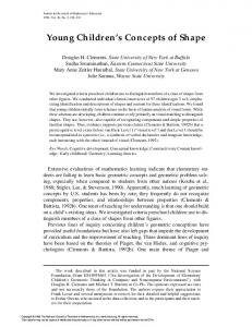
Environmental setting Fort Greely covers about 267,000 ha (661,341 acres) near Delta Junction in Central or Interior Alaska. The area is located in the southeast corner of the TananaKukodwim Lowlands Physiographic province (Wahrhaftig 1965) just north of and bordering the Alaska Range province. Elevations range from 400 to 1800 m, and because of its location just north of the Alaska range it has been glaciated and includes features such as glacial moraines, glaciofluvial sediments, and loess (Péwé and Holmes 1964, Church et al. 1965). The Washington Range occupies about 1650 ha (4125 acres) along the Delta River (Fig. 1) and is located on the Mount Hayes D-4 Quad-SW. The study area, about one-half of the Washington Range or 800 ha (2000 acres), is located on a terrace elevated several meters above the active channel of the Delta River. The Delta River is a broad, gravel-braided glacial outwash system west of the main cantonment area of Fort Greely that flows from the Alaska Range northward to the Tanana River (Dingman et al. 1971). The terrace was most likely formed during a more active period of sedimentation
a. View from Observation Point 10, Fort Greely, Alaska. Figure 1. Washington Impact Area.
2
to contents
b. Aerial photo (28 August 1998) showing general locations of ordnance firing events where samples were collected. Figure 1 (cont’d).
floodplains of the Delta River probably requires a much longer time for the development of forests (balsam poplar and white spruce), and at some stage grassy meadows appear to develop in places that are important grazing areas. Also, several legumes (Hedysarum, Astragalus, Oxytropis, Avena, Dryas drumondii, and D. octopetala) play a role in succession and willow is less important here than along the Tanana. Particularly striking on the Delta River floodplains is the abundance of silverberry shrubs (Eleagnus commutata). The vegetation of the Delta River floodplain on the Washington Range was mapped by Holmes and Benninghoff (1957) using August 1948 aerial photos on the Mount Hayes D4-SW topographic map base. Several meadow areas were mapped here in the middle of the Delta River floodplain. Later Jorgenson et al. (2001) mapped the vegetation on Fort Greely and
included the Washington Range as riverine gravelly barrens with species such as Oxytropis campestris, Dryas durommondii, Potentilla multifica, Shepherdia canadensis, Eleagnus commutata, Potentilla fruticosa, Fragaria virginiana, Populus balsamifera, and Stereocaulon sp. Much of the terrace of the Washington Range, where we sampled for explosives, is bare gravel with localized areas of sparse shrubs mostly consisting of silverberry (Fig. 2 and 3). Vegetation cover was generally negatively correlated with gravel increasing where there is more sand and silt. Estimates of shrub cover (silverberry) in each of the four 3-m × 3-m sampled plots varied from 15 to 40%. The forb Potentilla multifida was also abundant and cover by both mosses (up to 70%) and lichens suggests that the gravels here were well stabilized with little flooding.
3
to contents
Figure 2. Typical soil substrate and vegetation (silverberry shrub and yellow goldenrod as well as moss cover) in 81-mm mortar fuse test location. Each blue flag marks a fin from a mortar projectile.
southwest of a firing point along the right bank of a side channel of the Delta River. The 3-m-high × 10-mlong target berm was constructed of silty, sandy gravel with clasts up to 10 cm. Detailed information on the environment of Fort Greely may be obtained from the extensive field studies extending back to the 1950s when the Military Geology Branch of the USGS was contracted by the Corps of Engineers (WES) to conduct a terrain study of Fort Greely. A major summary and terrain study was produced in 1957 by Holmes and Benninghoff. This comprehensive study covered topography, geology, climate, hydrology, lakes, streams, soils and vegetation because these environmental factors influence training and testing activities on Fort Greely. Maps are included in volume 2 of the report and cover landforms (Mount Hayes D-4 and Big Delta A-4 [1:63,360]), geology–soils, and vegetation (Mount Hayes D-4 NE, NW, SE, SW [1:25,000]). Vegetation was mapped by Benninghoff from August 1948 aerial photos from U.S. Navy Mission BIG. More recently, from 1998 to 1999, CRREL and ABR, Inc. (Fairbanks, Alaska) conducted wildlife, plant, and vegetation inventories for the U.S. Army Alaska on Fort Greely (Jorgenson et al. 2001, Racine et al. 2001). Colorado State University also produced an Environmental Impact Statement for the USARAK for withdrawal of training lands, including Fort Greely.
American Bison (Bison bison) are the most conspicuous grazers on the Washington Impact Area. According to the ADF & G Web site (http:// www.state.ak.us/local/akpages/FISH.GAME/notebook/ notehome.htm) they were introduced in the Big Delta area in the 1920s and the original herd of 20 increased to over 500 animals by 1982. They move far up the Delta River in early spring to secluded meadows where they calve and around August they travel back downstream, eventually moving into the Delta Junction Bison Range. They feed on gravel bars on the Washington Impact Area, where they graze on various grasses and forbs such as vetch, but also eat silverberry, which is common on the study area. We also observed ground squirrels (Spermophilus parryii). The Lampkin Range is adjacent to an active side channel of the Delta River, about 10 km downstream of the Washington Impact Area. The Lampkin Range is used for various shorter-range direct-fire weapon systems. Firing points are located on elevated broad flat-topped gravel berms or platforms built on the vegetated floodplain along the right bank of the Delta River. Impact areas are to the southwest toward the Mississippi Impact Area, within the active channel system of the Delta River. For one particular test of 40mm grenades undertaken by CRTC, a target berm was constructed on a river gravel bar approximately 100 m
4
to contents
a. Sampling grid encompassing the densest concentration of fins (Area Blue). The red flag shows the location of a low-order detonation of an 81-mm projectile.
b. Sampling grid with no fins (Area Yellow). Figure 3. Sampling grids.
5
to contents
Range use In order to identify contaminants of concern, we needed to know what munitions have been fired into the areas we planned to sample. We were given range records for Fort Greely from 1987 to 1999. Records of the exact types of ammunition used on the Washington Range and Impact Area are available from 1998. These records contain the Department of Defense Identification Code (DODIC) that facilitates retrieval of information about the various components of the ammunition (i.e., explosive fillers, primers, propellants, etc.). Range records from 1987 to 1997 do not list DODIC numbers, only “type of round,” which does not identify the exact ammunition. From the most recent records, and the Munitions Item Disposition Action System (MIDAS) database (http://www.dac.army.mil/ TD/Midas/Index.htm), we generated tables summarizing some of the ammunition components (Tables A1 and A2). The tables are incomplete because several of the munitions used on the Washington Impact Area are either of foreign origin or the nature of the components is restricted information. Munitions not in the MIDAS database are flagged in Table A2.
and extensive site evaluation and remediation than may be necessary for responsible decision-making. The result is often higher-than-necessary expenditures of time and money, and insufficient data to address concerns of regulators and other interested parties. Range activities are susceptible to suspension in the absence of adequate scientific data to define potential affects on groundwater. For example, the possibility that groundwater was contaminated by training activities has resulted in suspension of training at the Massachusetts Military Reservation (USEPA 2000a). The Center for Health Promotion and Preventive Medicine (USACHPPM, formerly the U.S. Army Environmental Hygiene Agency) has sampled surface water on several ranges, including Fort Greely. Little or no residue of explosives has been detected in these surveys. Because of the dangers associated with unexploded ordnance on firing ranges, extensive soil sampling on ranges is a relatively recent activity (Table 1). With the exception of HMX on anti-tank ranges (Jenkins et al. 1997, 1998; Thiboutot et al. 1998) and RDX on hand grenade ranges, explosives have either been undetectable or at very low concentrations in soils collected from impact areas. Nonetheless, the detection of RDX in groundwater at the Massachusetts Military Reservation has led to questions as to the source of the RDX. Is it from leaking unexploded ordnance, loworder detonations, or residue from thousands of properly functioning projectiles? Further sampling on ranges should help to answer this question. Our objectives for the initial reconnaissance sampling program at Fort Greely were to
Munitions TNT (2,4,6-trinitrotoluene) and RDX (hexahydro1,3,5-trinitro-1,3,5-triazine) are the two most commonly used military explosives in projectiles, bombs, land mines, or other weapons (U.S. Army Materiel Command 1971, U.S. Army 1984). RDX is the explosive ingredient in Composition 4 (C4) that is used to detonate unexploded ordnance during range maintenance activities. HMX (octahydro-1,3,5,7tetranitro-1,3,5,7-tetrazocine) is the explosive filler in many anti-tank weapons and it is an impurity in militarygrade RDX. Nitroglycerin and 2,4-DNT (2,4dinitrotoluene) are ingredients in propellants. Barium (Ba), lead (Pb), chromium (Cr), cadmium (Cd), zinc (Zn), and antimony (Sb) are metals used in various primers. Unlike the organic explosives listed above, metals have natural background concentrations.
1. determine whether we could detect munitions residue in the soil of the Washington Impact Area; 2. determine what type of firing event or munition was associated with munitions residues detected; 3. test sampling methods appropriate for the soils and site conditions present; 4. acquire knowledge to assist us in developing sampling protocols to be applied in future to this and other impact areas on Fort Greely and elsewhere.
Objective of sampling Testing and training ranges are key elements in maintaining the capability and readiness of the U.S. Armed Forces. The potential for environmental impacts, including contamination of drinking water supplies, necessitates responsible management of these facilities in order to continue testing and training activities. Guidance for evaluation of the nature and extent of contamination and the fate of residues of energetic materials is inadequate to ensure sound management of ranges as sustainable resources. In the absence of guidance, facilities may be subject to more stringent
METHODS We focused our sampling on surface soils and collected both composite (multi-increment) and discrete samples. Methods for forming the composite samples were tailored to each firing event as described below. Sample locations were recorded using a Trimble GPS Pathfinder Pro XR system. The system uses real-time differential GPS to determine submeter (±20 cm)
6
to contents
Table 1. Summary of explosives detected by soil sampling on firing ranges.
Year 1990–1994 1995–1997
1996 1997 1998 1998 1998 1999 2000 2000 2000 1998–2000 2000
Range Eagle River Flats, Fort Richardson, Alaska CFB Valcartier, CFB Dundurn, Western Area Training Center-Wainwright Canadian Forces Base Valcartier Fort Ord Anti-tank Range Wellington Anti-tank Firing Range (CFB Gagetown) Castle Grenade Range (CFB Gagetown) CFB Chilliwack Camp Shelby, Mississippi Fort Lewis Impact Area and Firing Point Fort Lewis Hand Grenade Range Fort Richardson Hand Grenade Range Massachusetts Military Reservation Massachusetts Military Reservation
Contaminants found 2,4-DNT, TNT, RDX
Source
Reference a, b
HMX and TNT
From neighboring explosive ordnance disposal area Anti-Tank Rockets
HMX and TNT HMX and TNT HMX and TNT
Anti-Tank Rockets Anti-Tank Rockets Light AntiTank Weapon Rocket
c,d e f
RDX and TNT
Hand grenades
f
RDX and HMX
g
NG and 2,4-DNT 2,4-DNT TNT TNT and RDX TNT and RDX
Hand Grenades, C4, Anti-Tank Rockets Firing Point Firing Points Low-order detonations Hand grenades Hand grenades
NG and 2,4-DNT HMX, RDX, TNT, NG
Firing Points Rockets
c
h i i i j k
a. Racine et al. (1992) b. USAEHA (1994b) c. Thiboutout et al. (1998) d. Jenkins et al. (1997) e. Jenkins et al. (1998) f. Dube et al. (1999) g. Ampleman et al. (2000) h. USACHPPM (2000) i. Jenkins et al. (2001) j. Ogden (2000) k. USEPA (2000a)
accuracy for horizontal positioning. Universal Transverse Mercator (UTM) grid coordinates were determined for each sample or set of sample locations. Elevation data were also collected for each sample location. Because elevation data are not as precise as horizontal data using GPS systems, we also used a laser level to survey across the width of the terrace to determine elevational differences in the terrace and height above the active river channel.
detects TNT and other nitroaromatics, and 8510 (Field Method for the Determination of RDX in Soil), which detects RDX and other nitramines plus nitrate esters (USEPA 1996a, 2000b). We also used the Expray kit (EREZ Forensic Technologies, Israel) to identify explosive compositions found in the field. Based on the results of previous sampling on training ranges (USACHPPM 2000) where most of the samples were non-detects when analyzed by Method 8330 (Nitroaromatics and Nitramines by High-Performance Liquid Chromatography [HPLC]) (USEPA 1994), we knew that we needed to use an analytical method that provided detection limits less than 0.2 µg/g. We used Method 8095 (Nitroaromatics and Nitramines by GC) (USEPA 2000c), which uses an electron capture detector and provides detection limits near 0.001 µg/g for TNT and RDX. The method detection limits for Method 8095
ANALYTICAL METHODS Explosives Explosives were characterized using field and laboratory methods. Field procedures were the colorimetric Methods 8515 (Colorimetric Screening Method for Trinitrotoluene [TNT] in Soil), which
7
to contents
are 0.001 µg/g for the di- and trinitroaromatics, 0.003 µg/g for RDX, 0.025 µg/g for HMX, 0.01 µg/g for NG, and 0.02 µg/g for PETN. In this report, we report concentrations below the computed method detection limits if the concentrations were confirmed using a second GC column or using HPLC for HMX. We used Method 8330 (Nitroaromatics and Nitramines by HighPerformance Liquid Chromatography [HPLC]) (USEPA 1994) when we found higher concentration samples (>0.2 µg/g) and to quantify the explosives components in low-order detonations.
81-mm HE projectiles. We marked a 3-m × 3-m area encompassing the densest concentration of fins (Area Blue) and another 3-m × 3-m area nearby that contained no fins (Area Yellow) (Fig. 3). We also located a loworder detonation next to Area Blue (Fig. 3a). We sampled the explosive composition and the soil directly under the low-order detonation to a depth of 22 cm, the deepest we could reasonably dig through the cobbly substrate with a small shovel. From each of these areas, we used a small shovel to collect soil at the nodes of a 1-m-square grid (Fig. 3b) to form a composite soil sample. We excluded rocks (particles >2 mm) from the samples by either sampling around them or picking them out. Three 120-mL subsamples were obtained by taking 30 random increments from the composite for subsequent laboratory analysis for explosives residues. The remainder of the sample was placed in a plastic bag for other analyses (XRF and field colorimetric methods). In the field lab, we used colorimetric methods to test acetone extracts of the soil samples for nitroaromatics (Method 8515) and nitramines/nitrate esters (Method 8510). Method 8515 appeared to indicate the presence of nitroaromatic compounds. The initial background color of the acetone extract was yellow, and addition of the EnSys reagent (tetrabutyl ammonium hydroxide) resulted in an amber color. The color was more intense in the sample collected from the area without projectile fins. (Subsequent laboratory analysis showed that this color formation was due to the presence of elemental sulfur and sulfur compounds.) The following day, we marked out two additional 3-m × 3-m areas (labeled Areas Red and Pink) on either side of the two areas previously sampled in line with the firing point. Using gas chromatography-µECD (Method 8095), we detected low (