GIS Ostrava 2009 25. - 28. 1. 2009, Ostrava ___________________________________________________________________
Using of mobile device localization for several types of applications in mobile information systems Ondrej Krejcar 1
1
Department of Measurement and Control, Faculty of Electrical Engeneerings and Computer Science, VŠB Technical University of Ostrava, 17. Listopadu 15, 70833, Ostrava Poruba, Czech Republic
[email protected] Abstract. The area of interest is in a model of a radio-frequency based system enhancement for locating and tracking users of our information system inside the buildings. The developed framework as it is described here joins the concepts of location and user tracking as an extension for a new type of mobile information systems. The realized framework uses a WiFi network infrastructure to let a mobile device determine its indoor position. User location can be used by several types of applications. In first case the user location is used for data pre-buffering and pushing information from server to user’s PDA. All server data are saved as artifacts (together) with its position information in building. The accessing of prebuffered data on mobile device can highly improve response time needed to view large multimedia data. In second case the user location information is used for crisis management in large area buildings. Real-time position location can be used to track service personnel (e.g., police officers, rescue teams, fire brigades, etc.), lost children, suspected criminals, and stolen vehicles. Keywords: Wi-Fi; MDA; prebuffering; localization; framework; response time; crissis management
1
Introduction
The usage of various wireless technologies has been increased dramatically and would be growing in the following years. This will lead to the rise of new application domains each with their own specific features and needs. Also these new domains will undoubtedly apply and reuse existing (software) paradigms, components and applications. Today this is easily recognized in the miniaturized applications in network-connected PDAs that provide more or less the same functionality as their desktop application equivalents. It is very likely for these new mobile application domains to adapt new paradigms that specifically target the mobile environment. We believe that an important paradigm is context-awareness. Context is relevant to the mobile user, because in a mobile environment the context is often very dynamic and the user interacts differently with the applications on his mobile device when the context is different. While usually a desktop machine is in a fixed context, a mobile device may be used in work, on the road, during the meeting, or at home. Context is not limited to the physical world around the user, but also incorporates the user’s behavior, terminal and network characteristics. Context-awareness concepts can be found as basic principles in a long-term strategic research for mobile and wireless systems such as formulated in [10]. The majority of context-aware computing to date has been restricted to location-aware computing for mobile applications (locationbased services). However, position or location information is a relatively simple form of contextual information. To name a few other indicators of context awareness that make up the parametric context space: identity, spatial information (location, speed), environmental information (temperature), resources that are nearby (accessible devices, hosts), availability of resources (battery, display, network, bandwidth), physiological measurements (blood pressure, heart rate), activity (walking, running), schedules and agenda settings. Context-awareness means that anybody is able to use context information. The proliferation of mobile computing devices and local-area wireless networks has fostered a growing interest in location-aware systems and services. A key distinguishing feature of such systems is that the application information and/or interface presented to the user is, in general, a function of his/her physical location. The granularity of needed location information could vary from one application to another. For example, locating a nearby printer requires fairly coarse-grained location information whereas locating a book in a library would require fine-grained information. While much research has been focused on a development of services architectures for location-aware systems, less attention has been paid to the fundamental and challenging problem of locating and tracking mobile users, especially in in-building environments. We focus mainly on RF wireless networks in our research. Our goal is to complement the data networking capabilities of RF wireless LANs with
GIS Ostrava 2009 25. - 28. 1. 2009, Ostrava ___________________________________________________________________ accurate user location and tracking capabilities for user needed data pre-buffering. This property we use as an information ground for extension of control system. We consider location as prime form of context information. We are focused on position determination in an indoor environment. Location information is used to determine an actual user position and his future position. We have performed a number of experiments with the control system, focusing on the position determination we are encouraged by the results. The remainder of this paper describes the conceptual and technical details.
2
Basic Concepts and Technologies
Among the many location systems proposed in the literature, the most effective are those based on radio location techniques that exploit measurements of physical quantities related to radio signals travelling between the mobile terminal (MT) and a given set of transceivers whose location is known, e.g., base stations (BSs) and/or navigation satellites. Radio signal measurements are typically the received signal strength (RSS), the angle of arrival (AOA), the time of arrival (TOA), and the time difference of arrival (TDOA). Radio location techniques are generally classified into two categories: modified and unmodified handset solutions. The former techniques require some adjustment to be implemented in existing handsets, while the latter ones only need modification at the BS sites or switching centers. It is apparent that installing a global positioning system (GPS) receiver on each handset seems to be the most straightforward positioning approach. However, additional hardware and required computational burden reduce the power efficiency and increase the weight, size, and cost of the MTs. Moreover, the GPS receiver needs the simultaneous visibility of at least four satellites, which is not guaranteed in indoor and urban environments. To improve reliability and reduce time to position fix, wireless network information can be combined with satellite positioning, as suggested in assisted-GPS (A-GPS) techniques. Nevertheless, the biggest drawback remains the number of modifications required at both the handset and the fixed network infrastructure. Therefore, radio location techniques based on less expensive unmodified terminals represent a promising tradeoff between performance and overall implementation complexity. 2.1
Radio Location Techniques in Wireless Communications Systems
The radiolocation techniques are classified into two main groups on the basis of the number of BSs involved in the estimation process, i.e., one BS or multiple BSs. They can be implemented in any wireless communication system, provided that reliable measurements of the physical quantities related to known signals travelling either from the BSs to the MT (downlink) or from the MT to the BSs (uplink) are available. In the downlink case, location measurements are generally made using a reference signal (named "pilot") broadcast by all the BSs with the same power. RSS Algorithm Requiring More Than One BS The technique described here call for a minimum number of simultaneously available BSs, which could not be always guaranteed in actual environments wherein the number of signals received at the MT with a sufficient power level may be lower than that required by the location algorithm ("hearability" problem). RSS positioning algorithm is based on the measurement of the RSS of a known training sequence sent by the MT to different BSs. If the transmit power is known, the distance between a BS and the MT can be estimated using the received power level and a proper mathematical model for the path loss attenuation law. As a signal strength measurement provides a distance estimate, the MT must lie on a circle centered at the BS. By using at least three BSs to resolve ambiguities, the MT position estimation can be identified via a trilangulation technique at the intersection point of the relevant circles. Power control strategies commonly used in wireless cellular systems may, however, hinder the effectiveness of such a technique. Single-BS Algorithms Single-BS solutions offer many advantages over multiple BS ones. The coverage by several BSs (i.e., the hearability) is no longer a problem. Finally, the internetwork signaling requirement (also termed "back-haul") is significantly reduced. On the other hand, most of these methods are prone to
GIS Ostrava 2009 25. - 28. 1. 2009, Ostrava ___________________________________________________________________ severe performance degradation in NLOS conditions. The cell identification (Cell-ID) technique (as one example) simply identifies the position of the MT with that of the serving BS. While the idea of the Cell-ID is attractive for its simplicity and low implementation costs, its accuracy is inversely proportional to the cell size and could be not adequate for the FCC requirements and the most demanding location services. 2.2
Data Collection
A key step of the proposed research methodology is a data collection phase. We record information about the radio signal as a function of a user’s location. The signal information is used to construct and validate models for signal propagation. Among other information, the WaveLAN NIC makes the signal strength (SS) and the signal-to-noise ratio (SNR) available. SS is reported to units of dBm and SNR is expressed in dB. A signal strength of Watts is equivalent to 10*log10(s/0.001) dBm. For example, signal strength of 1 Watt is equivalent to 30 dBm. Each time the broadcast packet is received the WaveLAN driver extracts the SS information from the WaveLAN firmware. Then it makes the information available to user-level applications via system calls. It uses the wlconfig utility, which provides a wrapper around the calls to extract the signal information.
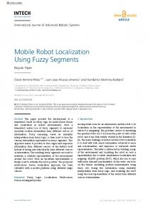
Fig. 1. Localization principle - triangulation
2.3
Localization Methodology
The general principle states that if a WiFi-enabled mobile device is close to such a stationary device – Access Point (AP) it may “ask” the provider’s location position by setting up a WiFi connection. If the mobile device knows the position of the stationary device, it also knows that its own position is within a 100-meter range of this location provider. Granularity of location can improve by triangulation of two or several visible WiFi APs. The PDA client will support the application in automatically retrieving location information from nearby location providers, and in interacting with the server. Naturally, this principle can be applied to other wireless technologies. The application (locator) is now implemented in C# using the MS Visual Studio .NET 2005 with .NET compact framework and a special OpenNETCF library enhancement [6]. Schema on figure [Fig. 1] describes a localization process. The mobile client gets the WiFi SS of three BSs with some inaccuracy. Circles around the BSs are crossed in red points on figure. The intersection red point (centre of three) is the best computed location of mobile user. The user track is also computed from these measured WiFi intensity level and stored in database for later use.
GIS Ostrava 2009 25. - 28. 1. 2009, Ostrava ___________________________________________________________________ 2.4
WiFi Middleware
The WiFi middleware implements the client’s side of location determination mechanism on the Windows Mobile 2005 PocketPC operating system and is part of the PDA client application. The libraries used to manage WiFi middleware are: AccessPoint, AccessPointCollection, Adapter, AdapterCollection, AdapterType, ConnectionStatus, Networking, NetworkType, and SignalStrength. 2.5
Predictive Data Push Technology
This part of the project is based on a model of location-aware enhancement, which we have used in created control system. This technique is useful in framework to increase the real dataflow from wireless access point (server side) to PDA (client side). Primary dataflow is enlarged by data prebuffering. These techniques form the basis of predictive data push technology (PDPT). PDPT copies data from information server to clients PDA to be helpful when user comes at desired location. The benefit of PDPT consists of reduction of time needed to display desired information requested by a user command on PDA. Time delay may vary from a few seconds to number of minutes. It depends on two aspects. First one is the quality of wireless Wi-Fi connection used by client PDA. A theoretic speed of Wi-Fi connection is max 687 kB/s, because of protocol cost on physical layer (app. 30-40 %). However, the test of transfer rate from server to client’s PDA, which we have carried out within our Wi-Fi infrastructure provided the result speed only 80 - 160 kB/s (depends on file size and PDA device). The second aspect is the size of copied data. Current application records just one set of signal strength measurements at the time (by Locator unit in PDPT Client). By this set of values the actual user position is determined by the PDPT server side. PDPT core responds to location change by selection of the artifact to load to PDPT client buffer. The data transfer speed is widely influenced by the size of these artifacts. For larger artifact size the speed is going down. Theoretical background and tests were needed to determine an average artifact size. First of all the maximum response time of an application (PDPT Client) for user was needed to be specified. A special book [8] of „Usability Engineering” specified the maximum response time for an application to 10 seconds. During this time the user was focused on the application and was willing to wait for an answer. We used this time period (10 second) to calculate the maximum possible data size of a file transferred from server to client (during this period). If transfer speed was from 80 to 160 kB/s the result file size was from 800 to 1600 kB. The next step was an average artifact size definition. We used a sample database of network architecture building plan (Autocad file type), which contained 100 files of average size of 470 kB. The client application can download during the 10 second period from 2 to 3 artifacts. The problem is the time, which is needed for displaying them. In case of Autocad file type we measured this time to average 45 seconds. This time consumption is certainly not acceptable, for this reason we are looking for a better solution. We need to use some basic data format, which can be displayed by PDA natively (BMP, JPG, GIF) without any additional striking time consumption. The solution is in format conversion from any to this native (for PDA devices). In case of sound and video format we also recommend using basic data format (wav, mp3, wmv, mpg).
GIS Ostrava 2009 25. - 28. 1. 2009, Ostrava ___________________________________________________________________
Fig. 2. PDPT Framework – prebuffering architecture
The final result of our real tests and consequential calculations is definition of artifact size to average value of 500 kB. The buffer size may differ from 50 to 100 MB in case of 100 to 200 artifacts. 2.6
Framework Design
PDPT framework design is based on the most commonly used server-client architecture. To process data the server has online connection to the control system. Technology data are continually saved to Microsoft SQL Server database [7] and [11]. The part of this database (desired by user location or his demand) is replicated online to client’s PDA, where it is visualized on the screen. User´s PDA has location sensor component, which continuously sends the information about nearby AP’s intensity to the framework kernel. The kernel processes this information and makes a decision if or how the part of SQL Server database will be replicated to client’s SQL Server CE database. The kernel decisions constitute the most important part of whole framework, because the kernel must continually compute the position of the user and track, and make a prediction of his future movement. After doing this prediction the appropriate data (part of SQL Server database) are pre-buffered to client’s database for the future possible requirements. The PDPT framework server is created as Microsoft web service to handle a bridge between SQL Server and PDPT PDA Clients. 2.7
PDPT Client
For testing and tuning of PDPT Core was created the PDPT Client application. This client realizes classical client to the server side and an extension by PDPT and Locator module. Figure [Fig. 3]
GIS Ostrava 2009 25. - 28. 1. 2009, Ostrava ___________________________________________________________________ shows classical view of data presentation from MS SQL CE database to user (in this case the image of Ethernet network in company area plan). Each process running in a PDPT client is measured in millisecond resolution to provide a feedback from real situation. Tabs PDPT and Locator present a way to tune the settings of PDPT values.
Fig. 3. PDPT Client – Windows Mobile application
3
User Localization in Intelligent Crisis Management
Many people define crisis management as emergency response or business continuity, while other people will only consider the public relations aspect [4]. They are all partially correct, but true crisis management has many facets. It must be thoroughly integrated into the organization’s structure and operations. Achieving an effective level of crisis management requires a thorough internal analysis, strategic thinking and sufficient discussion. Crisis Management is the umbrella term that encompasses all activities involved when an organization prepares for and responds to a significant critical incident. An effective crisis management program should be consistent with the organization’s mission and integrate plans such as Emergency Response, Business Continuity, Crisis Communications, Disaster Recovery, Humanitarian Assistance, etc. Fireman, police and rescue service are very important part of this crisis management. Management and coordination of this people is now practicable by shortwave communication (radio, transmitter), but new mobile communication technologies as PDA’s can level up potential and speed of action in crisis situations. As discussed before, we can locate any people with PDA running client software. But how localization of these people can help them? Advantage is in tracking of these people. For example when fireman arrive to crisis place, his PDA will make an interconnection to crisis management system of building which fireman arrive and the software on PDA will guide the fireman by shortest safe way directly to the centre of problem in the crisis building. In this case function, the PDA act as a navigator and it can help people to make a good orientation around unknown building. Navigating of rescue people is first but not last possibility which PDA and localization can help. The PDPT Framework can manage large multimedia artifacts as described before. Using of such multimedia files allow to access on PDA for example building plans, pictures of strategic points in environments (electricity case, gas pipe, etc.), video of standard function of machinery or furnishings, etc. These artifacts can be managed to the PDPT Framework by PDPT manager.
GIS Ostrava 2009 25. - 28. 1. 2009, Ostrava ___________________________________________________________________ 3.1
PDPT Framework Data Artifact Management
The PDPT Server SQL database manages the information (artifacts) in the context of their location in building environment. This context information is same as location information about user track. The PDPT core controls data, which are copied from the server to client´s PDA by context information (position info). Each database artifacts must be saved in database along the position information, to which it belongs.
Fig. 4. PDPT Framework data artifact manager
During the creating process of PDPT Framework the new software application called “Data Artifacts Manager” was created. This application manages the artifacts in WLA database (localization oriented database). User can set the priority, location, and other metadata of the artifact. This manager substitutes the online conversion mechanism, which can transform the real online control system data to WLA database data artifacts during the test phase of the project. This manager can be also used in case of offline version of PDPT Framework usage [Fig 4]. The Manager allows to the administrator to create a new artifact from multimedia file (image, video, sound, etc.), and edit or delete the existing artifact. The left side of the screen contains the text field of artifact metadata as a position in 3D space. This position is determined by artifact size (in case of building plan) or binding of artifact to some part of a building in 3D space. The 3D axis is possible to take from building plan by some GIS software like Quantum GIS or by own implementation. The central part represents a multimedia file and right side contains the buttons to create, edit, or delete the artifact. The lower part of the application screen shows actual artifacts in WLA database located on SQL Server.
GIS Ostrava 2009 25. - 28. 1. 2009, Ostrava ___________________________________________________________________ 4
EXPERIMENTS
We have executed a number of indoor experiments with the PDPT framework using the PDPT PDA application. WiFi access points are placed at different locations in building, where the access point cells partly overlap. We have used triangulation principle of AP intensity to obtain a better granularity. It has been found that the location determination mechanism selects the access point that is the closest to the mobile user as the best location provider. Also after the loss of IP connectivity, switching from one access point to another (a new best location provider) takes place within a second in the majority of cases, resulting in only temporary loss of IP connectivity. This technique partially uses a special Radius server [4] to realize “roaming” known in cell’s networks. User, who lost the existing signal of AP is required to ask the new AP to receive IP. This is known as “renew” in Ethernet networks. At the end of this process, user has his identical old IP and connection to new AP. Other best technique to realize roaming is using of WDS (Wireless Decision System). 4.1
Data Transfer Increase Tests Using PDPT Framework
We have executed a number of indoor experiments with the PDPT framework using the PDPT PDA application. The main result of utilization of PDPT framework is reduction of data transfer speed. The result of one of these tests is presented here. We focused on the real usage of developed PDPT Framework on wide scale of mobile lightweight devices and its main issue at increased data transfer. For test five mobile devices was selected with different operating system (Microsoft Windows Mobile 5.0, 6.0, 6.1) and a wide scale of memory, display resolution and user interface. For reliability of test we select a test track between two buildings of our university campus environment. User with each device go throw the defined environment where WiFi signal is present (number of AP vary from 1 to 4 visible at a time) ten times for better predicative value. For test we select two main collection of artifact according to their size (medium – 300-500 kB, large – 500-800 kB). During the movement of user the WiFi localization was enabled, so according the user position the artifacts was prebuffered to user PDA buffer (SQL CE database). At destination field we check the number of prebuffered artifacts and this number was compute as Successful rate [Table 1]. Table 1. Data transfer tests description.
Test 1 2 3 4 5 6 7 8 9 10
Type of device iPAQ h4150 HTC Blueangel HTC Roadster HTC Universal HTC Athena
Data artifacts collection Medium artifacts Large artifacts Medium artifacts Large artifacts Medium artifacts Large artifacts Medium artifacts Large artifacts Medium artifacts Large artifacts
Successful rate [%] 84 64 91 75 92 79 96 84 98 87
The results surpass our expectations with high quality of successful rate. This rate varies from 84 to 98 % in Athena device case. With large artifacts collection these rates go quite down, but is still very useful for real using of PDPT framework. Is evident the prebuffering techniques can help to use of medium or large artifacts in information systems. If we can transform the real data from information system to artifacts with their positions information, we can improve the transfer rate of used wireless connection and have a better response to users.
ACKNOWLEDGMENT This work was supported by the Ministry of Education of the Czech Republic under Project 1M0567
GIS Ostrava 2009 25. - 28. 1. 2009, Ostrava ___________________________________________________________________ 5
CONCLUSIONS
The main objective of this paper is in the enhancement of control system for locating and tracking of users inside a building. It is possible to locate and track the users with high degree of accuracy. In this paper we have presented the control system framework that uses and handles location information and control system functionality. The indoor location of a mobile user is obtained through an infrastructure of WiFi access points. This mechanism measures the quality of the link of nearby location provider access points to determine actual user position. User location is used in the core of server application of PDPT framework to data pre-buffering and pushing information from server to user’s PDA. Data pre-buffering is the most important technique to reduce time from user request to system response. The experiments show that the location determination mechanism provides a good indication of the actual location of the user in most cases. The median resolution of the system is approximately five meters. Some inaccuracy does not influence the way of how the localization is derived from the WiFi infrastructure. For the PDPT framework application this was not found to be a big limitation for the PDPT framework application as it can be found at chapter Experiments. The experiments also show that the current state of the basic technology, which was used for the framework (mobile device hardware, PDA operating system, wireless network technology) is now at the level of a high usability of the PDPT application [2].
REFERENCES 1. Evennou F., Marx F.: Advanced integration of WiFi and inertial navigation systems for indoor mobile positioning, In Eurasip journal on applied signal processing, Hindawi publishing corp., New York, USA, (2006) 2. Janckulik, D., Krejcar, O., Martinovic, J.: Personal Telemetric System – Guardian, In Biodevices 2008, pp. 170-173, Insticc Setubal, Funchal,Portugal, (2008) 3. Krejcar, O.: Prebuffering as a way to exceed the data transfer speed limits in mobile control systems, In Icinco 2008, 5th International Conference on Informatics in Control, Automation and Robotics, Insticc Press, Funchal, Portugal (2008) 4. Nielsen J.: Usability Engineering, Morgan Kaufmann, San Francisco, (1994) 5. Olivera V., Plaza J., Serrano O.: WiFi localization methods for autonomous robots, In Journal Robotica, vol. 24, pp. 455-461, Cambridge Univ. Press, USA, (2006) 6. OpenNETCF - Smart Device Framework, http://www.opennetcf.org 7. Reynolds, J.: Going Wi-Fi: A Practical Guide to Planning and Building an 802.11 Network, CMP Books, (2003) 8. Salazar A.: Positioning Bluetooth (R) and Wi-Fi (TM) systems, In Journal IEEE transactions on consumer electronics, vol. 50, pp. 151-157, IEEE-INST Electrical Electronics Engineers Inc., USA, (2004) 9. The Internet Engineering Task Force RADIUS Working Group, http://www.ietf.org/ 10. The Wireless World Research Forum (WWRF), http://www.wireless-world-research.org/ 11. Tiffany, R.: SQL Server CE Database Development with the .NET Compact Framework, Apress, (2003) 12. Wigley, A., Roxburgh, P.: ASP.NET applications for Mobile Devices, Microsoft Press, Redmond, (2003) 13. Krejcar, O., “Benefits of Building Information System with Wireless Connected Mobile Device - PDPT Framework”, In 1st IEEE International Conference on Portable Information Devices, Portable 2007, Orlando, Florida, USA, March 25-29, 2007, pp. 251-254, (2007) 14. Krejcar, O., “User Localization for Intelligent Crisis Management”. In 3rd IFIP Conference on Artificial Intelligence Applications and Innovations 2006, AIAI 2006, Springer, IFIP, Volume 204, June 7-9, 2006, Athens, Greece. p. 221-227. DOI 10.1007/0-387-34224-9_26 (2006) 15. Krejcar, O., “PDPT framework - Building information system with wireless connected mobile devices”, In Icinco 2006, 3rd International Conference on Informatics in Control, Automation and Robotics, , Insticc Press, Setubal, Portugal, pp. 162-167 (2006)