Feature pubs.acs.org/est
Web-Based Environmental Simulation: Bridging the Gap between Scientific Modeling and Decision-Making Wouter Buytaert,*,† Selene Baez,‡ Macarena Bustamante,‡ and Art Dewulf § †
Civil and Environmental Engineering and Grantham Institute for Climate Change, Imperial College London, Skempton Building, SW7 2AZ London, U.K. ‡ CONDESAN, Quito, Ecuador § Public Administration and Policy Group, Wageningen University, Wageningen, The Netherlands directly, requesting particular scenarios and tailored simulations. Such “do-it-yourself” simulation has the potential to turn the typical top-down flow of information from scientists to users into a much more direct, interactive approach. It opens perspectives to speed up the dissemination of environmental information to a larger community of users, to harvest feedback, and to widen the opportunity to evaluate simulations and predictions from different perspectives. However, this evolution comes with the challenge of communicating modeled results in such a way that they can be interpreted correctly and are not used in an inappropriate context.
■
■
INTRODUCTION Data availability in environmental sciences is expanding at a rapid pace. From the constant stream of high-resolution satellite images to the local efforts of citizen scientists, there is an increasing need to process the growing stream of heterogeneous data and turn it into useful information for decisionmaking. Environmental models, ranging from simple rainfall− runoff relations to complex climate models, can be very useful tools to process data, identify patterns, and help predict the potential impact of management scenarios. But the complexity of most environmental models typically confines them to scientific laboratories and academic computer clusters, where they are harnessed by researchers who understand the algorithms, assumptions, simplifications, and potential errors of these models. As a result, decision-makers often have high and unrealistic expectations regarding scientific knowledge and environmental models. The risk exists that they will see them as clear-cut cases for particular policies,1 or contrarily, they may lack confidence in models and results that they cannot reproduce themselves. The integration of information provided by environmental models into policy formulation is therefore quite a challenge. In their efforts, scientists and decision-makers may be helped or criticized by third parties of citizen scientists collecting local data2 and challenging model results and management decisions. Recent technological innovations in networking and computing (among which those that underpin the interactive Web 2.0) may bring a new generation of interactive models plugged into virtual environments closer to the end-user. They are the driver of major funding initiatives such as the UK’s Virtual Observatory program, and the U.S. National Science Foundation’s Earth Cube. Even though the intricacies of code development and data assimilation themselves may still be hidden in laboratories and supercomputer centers, various interfaces may allow end-users to interact with them more © 2012 American Chemical Society
INCREASING NEEDS FOR ENVIRONMENTAL DATA PROCESSING AND SIMULATION For the indigenous communities of the Pacaya-Samira National Reserve in the Peruvian Amazon, turtle egg harvesting is a successful survival strategy. The practice keeps the natural animal population numbers up and provides a necessary source of food and income. However, the success of the activity is dependent on information on the variability in the river level, which may flood nesting beaches at crucial times. In the Yasuni ́ National Park in the Ecuadorian Amazon, bush meat hunting regions are threatened by encroaching deforestation. Further upstream, in Andean highlands of Ecuador and Peru, the availability and quality of irrigation water depends strongly on upland land management, as well as the reliability of precipitation and glacier melt, which future climate change may affect.3 In these areas and in many others worldwide, a sustainable management of the natural resources is crucial for local socioeconomic development. The given examples face very different environmental problems. But in all of them, data and resources tend to be scarce compared to the complexity of the issues faced. It is therefore essential that local managers have optimal access to existing data and simulation methods to design management strategies, and optimize ecosystem management and human development. Many developed countries also struggle to manage ecosystem resources in a context of accelerating environmental change. Data availability may be less of an issue here, but the data come in many different forms and formats, and are collected and stored by a plethora of different institutes and entities. The increasing stress on environmental processes requires that management strategies take into account the complexity of strongly interconnected environmental and socio-economic systems. Published: January 17, 2012 1971
dx.doi.org/10.1021/es2031278 | Environ. Sci. Technol. 2012, 46, 1971−1976
Environmental Science & Technology
Feature
process, which may yield new evaluation strategies and quicker model improvement. Applying models that continuously incorporate new data and knowledge within an adaptive management cycle can provide better outcomes in the context of uncertainty8 and offer the opportunity to incorporate citizen scientists’ feedback. Such a process is now becoming easier through web-enabled data processing.
Resolving the interactions between different processes in integrated models is a convenient approach to understand the potential impact of management and policy decisions. The Virtual Observatory program of the UK Natural Environment Research is one of several attempts to create a common platform for environmental data, models, and decision support systems. In the U.S., the recently announced Earth Cube initiative of the National Science Foundation has similar aims, as has the Global Earth Observation System of System (GEOSS). They all aim at providing environmental simulations and predictions that result from advanced integration of climatic, hydrological, ecological, social and other data to inform management decisions. However, not only in large-scale virtual observatories, but also in small scale citizen science,4 there is a growing need for more integration in sharing and processing of data and information. Although the accuracy of a single sensor or amateur observation is often less than that of a more expensive alternative, the ability to employ them in large quantities may provide valuable information, for instance where spatial patterns are highly variable or of particular importance. Such data collection is often driven by citizens or environmental managers with a local interest. It is therefore paramount that any scientific knowledge generated from these data is fed back to the data collectors, either to support local ecosystem management, or as an education process to increase the lifespan of a communitybased monitoring system. In the above-mentioned example of improving irrigation in the Andes, one of the main issues is the lack of hydrometeorological data. As in many other regions the number of hydrometeorological stations in the region has been in gradual decline since in the 1980s.5 Existing monitoring networks are concentrated in valleys where most of the economic activity happens. This is of little help to smallholder farmers in the mountain headwaters, such as those of the Pacaipampa region in northern Peru. With the help of local organizations they try to improve agricultural practices to make their farming on steep slopes more sustainable, and to reconcile human activities with the conservation of valuable wetland ecosystems.6 Recognizing that basic information on precipitation and streamflow is essential to a better understanding of the local hydrology, the farmers of Pacaipampa have installed electronic rain and streamflow gauges. Data are collected by a local organization and processed for basic visualization.7 The results of the project are positively received by the local community. It allows them to identify headwater catchments with a strong water regulation, which should be left undisturbed as water supply areas. But the potential of such projects is much larger. Although raw data are useful for understanding local processes such as runoff generation dynamics and water yield, water managers are more interested in anticipating the potential impact of management scenarios, such as reforestation, exclusion of livestock, and restoration of wetlands. Typically, these impacts are predicted using physically based hydrological models. However, implementing environmental models for complex regions such as the tropical Andes is challenging. Because models are complex, scientists are needed to develop and run them. To do so, scientists often need local data and insights. At the other end, users may benefit from better interaction with model developers to understand the model’s abilities and deficiencies. Therefore, more interaction and exchange among data collectors, model developers, and end-users/decision makers is needed. This may lead to a rich two-way learning
■
UBIQUITOUS SENSING, SOFTWARE INTEGRATION, AND THE ROLE OF WEB SERVICES
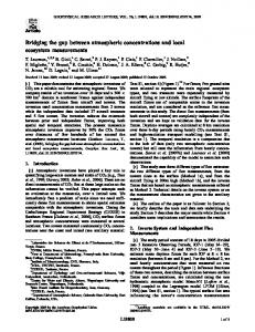
Driven by technological developments, environmental sensors are becoming smaller, cheaper, and increasingly automated. They can be employed in pervasive sensor networks9 and connected to the Internet where they provide constant streams of data.10 Similarly, environment agencies worldwide are starting to put historical and recent data online, helped by emerging standards for data formatting and access.11 The need to process these data efficiently has driven the development of workflow management systems to facilitate data processing.12 Increasingly, these tools are web-enabled. Not only does this facilitate their deployment, avoiding the need to install software on a particular machine, it has several other advantages. Processingor memory-intensive parts of the analysis can be delegated to commercial cloud computing facilities. This speeds up processing, especially for tasks that involve large, parallel calculations, as is typical for uncertainty analyses (e.g., Markov Chain Monte Carlo methods). Another advantage is that model components can be hosted online. For instance, rather than having to download and install a rainfall−runoff model, it may be made available as a web service by a commercial company or research group, allowing users to send off the input data and get the output data in return.13 Technologies for the deployment of model components online are currently under development. For instance, the Open Geospatial Consortium’s (OGC) Web Processing Service14 provides rules for standardizing how inputs and outputs (requests and responses) for geospatial processing services need to be formulated. The standard also defines how a client can request the execution of a process, and how the output from the process is handled. Similarly, data models are being defined to facilitate the unambiguous exchange of information between different models, as well as metadata including uncertainties. Notable examples are the Observations Data Model developed by the Consortium of Universities for the Advancement of Hydrological Sciences Inc. (CUAHSI15), now being adopted as part of the suite of standards of OGC, or OGC’s own Observations and Measurements.16 These developments provide far-reaching opportunities for decision-support systems. The availability of online databases and models as web services allows for their inclusion not only in professional workflows, but also in interactive tools for data querying and simulation aimed at decision-making. 13 The integration of sensors, models, visualization, and other tools in a common cyber-infrastructure is sometimes referred to as the construction of a Virtual Observatory (Figure 1). An example in the form of a web-based early warning system for flooding has been developed for the Demer river basin in Belgium,17 while several others are part of the GEOSS system. 1972
dx.doi.org/10.1021/es2031278 | Environ. Sci. Technol. 2012, 46, 1971−1976
Environmental Science & Technology
Feature
Virtual observatories can help address the scaling issue in environmental science and policy, through linking local level data and knowledge with global data into environmental models. Finally, the data have a wider scientific and policy-making value, for instance to understand poorly known ENSO driven precipitation anomalies in northern Peru. Therefore, if these data become publicly available through a virtual observatory, they can contribute to the development of new knowledge, as well as a more transparent and effective decision-making and policy assessment. The development of a virtual environment where data and models are integrated through web services is critical for setting up virtual observatories. Web portals can be used to allow local practitioners to upload raw archives of sensor data (if it is impossible to connect those sensors directly with the Internet). Automatic algorithms may provide basic processing, quality control, interpolation, and visualization.10 Simulations on how data decrease the uncertainty of model projections may inform decisions about future data collection, and their technical characteristics (e.g., frequency and density of measurements). Especially when financial, technical, and scientific resources are scarce, there is a risk that such decisions are taken ad-hoc. Depending on the nature of the issue and the available model simulations, decision makers can use the resulting information for real-time operational decisions-making (e.g., data on water levels for flood management), medium-term management decisions (e.g., hydrological model predictions for land use change decisions), or for long-term strategic investment decisions (e.g., climate projections for infrastructural decisions). Web technologies allow many new forms and levels of interactions between models and human actors. The science of visualizing data, including uncertain predictions, has a long history.19,20 Existing methods can be readily applied in web environments, with the added benefit of instantaneity and interaction. The availability of vast data and processing power over the Internet has led to “a golden age of infographics, (i.e. graphical representations of data intended for a nontechnical audience)”.20 An advanced example of interactive infographics is the UK Government’s my205021 simulator, which allows users to interact with carbon emission data and create their own scenarios for the future. It provides an appealing visualization of complex data, many of which are generated by models of some sort. Although my2050 and similar sites provide a more engaging user experience than static Web sites or print media, the type of information exchange is still mostly from the Web site to the user. However, information collection from end-users or third party actors is becoming more common. Many applications exist of massive analysis of the data that are uploaded daily to the public domain. For instance, applications are known of filtering twitter feeds for a variety of purposes, including predictions of the stock market22 and spotting of animal species.23 From there it should only be a small step toward more targeted forms of data harvesting. For instance, pictures taken by GPSenabled smartphones are automatically tagged with the geographic location and a timestamp. Combined with suitable image processing software, they can provide evidence of a large variety of environmental observations such as the extent of a predicted flood. User input may also be enabled directly through editable content such as maps. Google Map Maker24 is one of many examples. Engaging local knowledge within the data collection and modeling process is also critical to ensure benefits for the
Figure 1. Schematic of a virtual observatory of interconnected webservices providing interactive simulation functions for decision-support.
■
TOWARD INTERACTIVE AND OPEN ENVIRONMENTAL MANAGEMENT SYSTEMS The farmers in Pacaipampa in the highlands of Peru are currently benefiting from an increased understanding of the water cycle of the local ecosystems, but their insight in the potential hydrological impacts of land-use practices is still limited. For this, more advanced simulation is needed. For instance, in combination with data on land-cover and runoff generation processes, the precipitation records can be used as input for a hydrological model to simulate the impact of land-use changes, for instance reforestation, on water quality and quantity (Figure 2). Not only would this help to optimize local land-use
Figure 2. Prototype of an online decision-support system driven by a hydrological model, allowing simulation of the impact of land-cover changes on the hydrological response.
management, it will also provide valuable information on the provision of ecosystem services between the uplands and the lowlands. Indeed, the effect of land-use changes extends beyond the local interest. Water resources from the wetter highlands are a crucial ecosystem service for the dry, coastal lowlands with extensive irrigation systems.18 Irrigators may be interested in systems that combine the observations with the outputs of global weather models to provide better weather forecasts. 1973
dx.doi.org/10.1021/es2031278 | Environ. Sci. Technol. 2012, 46, 1971−1976
Environmental Science & Technology
Feature
statistical theory. However, uncertainties and errors in model structures may be epistemic rather than aleatory in nature and therefore much more difficult to fit in a classic statistical framework.28 One challenge is of a technical nature. Interconnecting models and data sets into complex simulation systems will also allow errors in the data and the simulations to propagate. Quantifying these errors and tracking their propagation is essential. This is especially true when “new” data sources such as citizen scientist’s measurements and expert knowledge are linked into models. The development of markup languages for data exchange and their associated data models pays due attention to the need for metadata including uncertainties (e.g., WaterML, CUAHSI, UncertWEB15,29−31), but the implementation of these standards is still in its early stages. Many data sources that are currently available in the public domain have no straightforward error model. In the case of citizen scientists or volunteer data collection, the collectors may not have enough knowledge about the nature of the data to properly characterize their uncertainties. Either automated or expertassisted quality control systems will be needed. Such support could take the form of an online data input and storage application that facilitates the collection of metadata (e.g., a GPSenabled mobile phone application that automatically stores the location of a data point), or runs a set of automated quality control routines before flagging any potential anomalies to experts. Many data sets may need a model in itself to convert the raw piece of information into useful data, as is already the case for most satellite measurements (e.g., groundwater levels derived from the GRACE satellite32). The use of qualitative data in environmental modeling is yet more challenging. In hydrological modeling, a legacy of research exists on the use of nonformal performance measures based on expert opinions. This approach is pioneered by the GLUE methodology33 and explored widely thereafter, for instance in the use of fuzzy logic34 and soft data for multicriteria model calibration.35 However, citizen science and social networking may increase dramatically the amount of soft data available for assimilation in models. Especially for the local refinement of model strategies (as in the idea of models of everywhere36), expert opinions about model deficiencies and pathways for model improvement may be of particular importance. New methods will have to be developed to collect and make optimal use of this information. Once the major sources of model uncertainties are quantified, communicating model performance and the impact of simplifications and assumptions presents another challenge. Users will want to evaluate whether models are fit for (their) purpose using a wide range and potentially idiosyncratic set of criteria.37 It is not uncommon that models fail to produce useful data for policy comparison or good experimental management plans.37,38 Especially in decision-making processes where budgets are limited, interests need to be balanced. Where societal perspectives on environmental issues vary widely, uncertainties can easily be used and misused to promote or challenge particular policies. In this context the communication of the uncertainties, limitations, and assumptions of models is of paramount importance. This is perhaps most visible in the current climate change debate, where the uncertainties and deficiencies of climate models and data are heavily scritinized by different actors. For instance, in the case of the climate skeptic network Surface Stations, volunteers surveyed U.S. temperature station sites in
local population. To do so, participatory methodologies offer an opportunity to both gather information and validate models outputs. Virtual observatories may then become tools to integrating formal-scientific knowledge with local-context specific observations. Many types of social media are emerging that can enhance the interaction between both information streams. For instance, linking online simulation systems to voting systems as used in Facebook and Google+ allow users to express opinions about the quality of predictions, or the usefulness of these predictions for their decisions. Uploaded photos and other evidence may be linked to specific news-items or applications for easy identification. As another example, the use of specific keywords known as hashtags has gained popularity on twitter as a way to “classify” messages and facilitate searching. The application of these technologies can be seen as an extension of the experiment in radical scientific method of Lane et al.25 In this study, scientists met in person with members of the public to coproduce knowledge about flooding of Pickering, a small market town North Yorkshire, UK. Shared conceptual models, e.g., about peak attenuation and storm volume, play an important role in such joint knowledge generation. Although direct, face-to-face meetings are probably the fastest way of coproducing knowledge, they are time-consuming and resourceintensive and hence they may be complemented by online technologies. Implementing environmental models in a web context may thus bridge the gap between high-level environmental data analysis and the general public. Environmental models are perfectly suited to function in a simulation environment, allowing for “what if” scenario testing and “do-it-yourself” environmental decision-making, through web interfaces and even applications on mobile phones. Especially in areas with low Internet penetration such as developing countries, the latter hold a strong potential for information dissemination. All of this holds a promise of greater transparency and inclusive participation of citizens in environmental data collection, modeling, research, and decision-making. Where conflicting recommendations in environmental policy discussions result from using different data sets and/or model implementations in a nontransparent manner, virtual observatories may help to avoid or more easily address these controversies.
■
POTENTIAL PITFALLS AND CHALLENGES It is an aphorism that all models are wrong, though some may be useful. Of course, uncertain environmental model results are already heavily used in certain decision-making contexts, with the climate change debate being a prominent example.26,27 But opening up the access to new models for simulation purposes to a broader user community will present new challenges with regard to both characterizing uncertainties and to communicating the meaning of simulations and the impact of assumptions and errors. Especially when variable quality and informal data are used, input errors in those data will propagate and may be amplified by errors and simplifications in the model structure. It will therefore be essential to keep track of these errors when data and simulations flow continuously among data sets, model components, and repositories across the web. On a more fundamental level, a lot of questions remain to be solved about the way that model input uncertainties interact with necessarily simplified and incomplete model structures. Uncertainties in measurements have been subject to a long history of research, and are typically well represented by standard 1974
dx.doi.org/10.1021/es2031278 | Environ. Sci. Technol. 2012, 46, 1971−1976
Environmental Science & Technology
Feature
will play a leading role in this process. Many challenges will need to be addressed of how to design models, link them into networks, and let people interact with them. However, addressing these has the potential to greatly increase the value of environmental modeling to manage natural resources and optimize their benefits for local livelihoods.
an attempt to identify errors in commonly used climate data sets.39 As a result, a lot of attention has been paid to developing a language and visualization techniques for uncertainties. (For an overview see e.g., 20 and 27) Similarly, the meteorological community has come a long way in quantifying and communicating uncertain weather forecasts to the general public. If environmental data and models are more open and easier to access, it can therefore be expected that they will become increasingly subject to scrutinization and debate too. It is therefore essential that criteria be defined to assess the usefulness of model predictions for specific applications, as well as ways to communicate them. This contrasts with the current tendency to assess models on a limited set of performance measures, as is common for instance in hydrological models.40,41 Rather, the discipline of assessing the value of uncertain model predictions in a decision-making context will need to be expanded,42 so that it can contribute to the capacity of decision-makers to make convincing cases for their decisions without hiding the uncertainties, and to the capacity of citizens to accept the inevitable uncertainties surrounding any policy decision. Lastly, many environmental models themselves are currently not designed to work in a flexible and adaptive web environment, where the amount of data may be variable and the data themselves may come in various flavors of quality, resolution, and spatial support. For instance, many hydrological models are monolithic implementations of computer code43 with specific input data that may not be available under all conditions. If models are to be applied in a demand-driven environment, they will need to deal with a large variety of processes and data. Flexible model structures that adapt to data availability will be needed, but have only recently been explored.36,44 The scientific issues of web-enabling models can only be solved when underpinned by adequate technical developments. Standardization of web protocols for data exchange and model coupling are under development, but run the risk of poor adoption, proliferation of standards, and resistance from interest groups. There is an increasing awareness and interest among data providers to share data in the cloud. Especially governmental funding agencies such as the U.S. National Science Foundation and the UK Research Councils are encouraging or even requiring research results to be made available in the public domain, and provide the necessary facilities (e.g., the UK Centre for Environmental Data Archival). However, other data providers may rely on the commercialization of generated data for their business, while some data are restricted under government regulations. In these situations, authentication technologies could enable restricted access, rather than having to disable access totally. For instance, the future CMIP5 repository of the British Atmospheric Data Centre is implementing an access control architecture for the OPeNDAP services standard.45 OPeNDAP and similar access protocols may also eliminate current problems with proliferation of file formats, such as GRIB and NetCDF. Even though the formats are documented, their loose specification is often criticized as difficult to read and interpret. We conclude that the unprecedented availability and access to data through the Internet poses significant challenges to environmental scientists. Novel ways will have to be found to manage and analyze these data and to generate information relevant for environmental management. New web technologies provide exciting opportunities, both for processing information and for communicating to the end-user. Environmental models, being primary tools to extract information from raw data,
■
AUTHOR INFORMATION
Corresponding Author
*E-mail:
[email protected]. Biography Wouter Buytaert has a Ph.D. in Environmental Engineering from the University of Leuven (2004), and is a lecturer in hydrology and water resources at Imperial College London. His main research interest is water resources and environmental change, with a focus on tropical and subtropical regions. Selene Baez obtained her Ph.D. in Biology from the University of New Mexico (2007), and is an Associate Researcher at the Consortium for Sustainable Development for the Northern Andes Ecoregion (CONDESAN). Her research interest is in the interface of plant community ecology, global climate change, and human use of natural resources. Macarena Bustamante is an economist with a Masters degree in Environment, Development and Policy at the University of Sussex (2008). She investigates the role of institutions and economic incentives to promote sustainable development in fragile environments subject to global environmental change. Currently, she is an Associate Researcher at CONDESAN. Art Dewulf received his Ph.D. in Organizational Psychology at the University of Leuven (2006). After a postdoc at Leuven, he started working as Assistant Professor at the Public Administration and Policy Group in Wageningen University. Research themes include participatory technological innovation, adaptive water management, and climate adaptation governance.
■
ACKNOWLEDGMENTS The described case studies are funded by grant NE/I004017/1 of the UK Natural Environment Research Council (NERC) held by W.B. Development of the Virtual Observatory technology was supported by NERC contract NE/I00200/1. We thank the three anonymous reviewers for their useful comments and suggestions.
■
REFERENCES
(1) Brugnach, M.; Tagg, A.; Keil, F.; de Lange, W. J. Uncertainty matters: Computer models at the science-policy interface. Water Resour. Manage. 2007, 21, 1075−1090. (2) Ottinger, G. Buckets of Resistance: Standards and the Effectiveness of Citizen Science. Sci., Technol. Human Values 2010, 35, 244−270. (3) Buytaert, W.; Cuesta-Camacho, F.; Tobon, C. Potential impacts of climate change on the environmental services of humid tropical alpine regions. Global Ecol. Biogeogr. 2011, 20, 19−33. (4) Kolok, A. S.; Schoenfuss, H. L. Environmental Scientists, Biologically Active Compounds, and Sustainability: The Vital Role for Small-Scale Science. Environ. Sci. Technol. 2011, 45, 39−44. (5) Hannah, D. M.; Demuth, S.; van Lanen, H. A. J.; Looser, U.; Prudhomme, C.; Rees, G.; Stahl, K.; Tallaksen, L. M. Large-scale river flow archives: importance, current status and future needs. Hydrol. Processes 2011, 25, 1191−1200. (6) Buytaert, W.; Célleri, R.; De Bièvre, B.; Hofstede, R.; Cisneros, F.; Wyseure, G.; Deckers, J. Human impact on the hydrology of the Andean páramos. Earth-Sci. Rev. 2006, 79, 53−72. (7) De Bièvre, B. Proceedings of the Conference on Global Change and the World’s Mountains. Perth, September 28, 2010; Mountain Research Initiative, 2010.
1975
dx.doi.org/10.1021/es2031278 | Environ. Sci. Technol. 2012, 46, 1971−1976
Environmental Science & Technology
Feature
using fuzzy rule based performance measures. J. Hydrol. 2004, 291, 254−277. (35) Seibert, J.; McDonnell, J. On the dialog between experimentalist and modeler in catchment hydrology: Use of soft data for multicriteria model calibration. Water Resour. Res. 2002, 38, WR000978. (36) Beven, K. Towards integrated environmental models of everywhere: uncertainty, data and modelling as a learning process. Hydrol. Earth Syst. Sci. 2007, 11, 460−467. (37) Olsson, J. A.; Andersson, L. Possibilities and problems with the use of models as a communication tool in water resource management. Water Resour. Manage. 2011, 21, 97−110. (38) Walters, C. Challenges in adaptive management of riparian and coastal ecosystem. Conserv. Ecol. 2011, 1, 2. (39) Fall, S.; Watts, A.; Nielsen-Gammon, J.; Jones, E.; Niyogi, D.; Christy, J. R.; Pielke, R. A. Sr; Parodi, A.; Foufoula-Georgiou, E.; Emanuel, K. Analysis of the impacts of station exposure on the US Historical Climatology Network temperatures and temperature trends. J. Geophys. Res. 2011, 116, D14120. (40) Schaefli, B.; Gupta, H. V. Do Nash values have value? Hydrol. Processes 2007, 21, 2075−2080. (41) Stedinger, J. R.; Vogel, R. M.; Lee, S. U.; Batchelder, R. Appraisal of the generalized likelihood uncertainty estimation (GLUE) method. Water Resour. Res. 2008, 44, W00B06. (42) Laio, F.; Tamea, S. Verification tools for probabilistic forecasts of continuous hydrological variables. Hydrol. Earth Syst. Sci. 2007, 11, 1267−1277. (43) Buytaert, W.; Reusser, D.; Krause, S.; Renaud, J.-P. Why can’t we do better than Topmodel? Hydrol. Processes 2008, 22, 4175−4179. (44) Clark, M. P.; Slater, A. G.; Rupp, D. E.; Woods, R. A.; Vrugt, J. A.; Gupta, H. V.; Wagener, T.; Hay, L. E. Framework for Understanding Structural Errors (FUSE): A modular framework to diagnose differences between hydrological models. Water Resour. Res. 2008, 44, W00B02. (45) Kershaw, P.; Ananthakrishnan, R.; Cinquini, L.; Lawrence, B.; Pascoe, S.; Siebenlist, F. A Flexible Component based Access Control Architecture for OPeNDAP Services. Geophys. Res. Abstr. 2010, 12, EGU2010−9289.
(8) Schreiber, S.; Bearlin, A.; Nicol, S.; Todd, C. Adaptive management: a synthesis of current understanding and effective application. Ecol. Manage. Restor. 2004, 5, 177. (9) Hart, J. K.; Martinez, K. Environmental Sensor Networks: A revolution in the earth system science? Earth-Sci. Rev. 2006, 78, 177−191. (10) Williams, M.; Cornford, D.; Bastin, L.; Jones, R.; Parker, S. Automatic processing, quality assurance and serving of real-time weather data. Comput. Geosci. 2011, 37, 353−362. (11) Usländer, T.; Jacques, P.; Simonis, I.; Watson, K. Designing environmental software applications based upon an open sensor service architecture. Environ. Model. Software 2010, 25, 977−987. (12) Bajcsy, P. A Perspective on Cyberinfrastructure for Water Research Driven by Informatics Methodologies. Geogr. Compass 2008, 2040−2061. (13) Goodall, J. L.; Robinson, B. F.; Castronova, A. M. Modeling water resource systems using a service-oriented computing paradigm. Environ. Model. Software 2011, 573−582. (14) Schut, P. OpenGIS Web Processing Service 1.0.0. OpenGIS standard 05-007r7; 2007. http://www.opengeospatial.org/standards/ wps, accessed August 1, 2011. (15) CUAHSI website. WaterOneFlow Web Services and WaterML. http://his.cuahsi.org/wofws.html, 2011. (16) Open Geospatial Consortium website. http://www. opengeospatial.org/standards/om, accessed August 3, 2011. (17) Schelfaut, K.; Pannemans, B.; Van Der Craats, I.; Krywkow, J.; Mysiak, J.; Cools, J. Bringing flood resilience into practice: the FREEMAN project. Environ. Sci. Policy 2011, 14, 825−833. (18) Buytaert, W. Climate Change & Water Resources. A Global Village 2011, 5, 36−39. (19) Tufte, E. The Visual Display of Quantitative Information; Graphics Press: Cheshire, CT, 2001. (20) Spiegelhalter, D.; Pearson, M.; Short, I. Visualizing uncertainty about the future. Science 2011, 333, 1393−1400. (21) Department of Energy and Climate Change. http://my2050. decc.gov.uk/, accessed 19 December 2011. (22) Bollen, J.; Mao, H.; Zeng, X. Twitter mood predicts the stock market. J. Comput. Sci. 2011, 2, 1−8. (23) Fuka, M. Z.; Fuka, D. R. Methods for extracting climate indicator data from social media. Proceedings of the AGU General Meeting, December 5−9 2011; San Francisco, 2011, H11B-1061. (24) Google Map Mapper. http://www.google.com/mapmaker, accessed December 20, 2011. (25) Lane, S. N.; Odoni, N.; LandströIL̀ ́, C; W., N.; Whatmor, S J; Bradley, S. Doing flood risk science differently: an experiment in radical scientific method. Trans. Inst. Br. Geogr. 2011, 36, 15−36. (26) Stainforth, D. A.; Downing, T. E.; Washington, R.; Lopez, A.; New, M. Issues in the interpretation of climate model ensembles to inform decisions. Philos. Trans. R. Soc., A 2007, 365, 2163−2177. (27) IPCC. Climate Change 2007 - Impacts, Adaptation and Vulnerability; Cambridge University Press: Cambridge, 2007. (28) Beven, K.; Smith, P. J.; Woods, A. On the colour and spin of epistemic error (and what we might do about it). Hydrol. Earth Syst. Sci. 2011, 15, 3123−3133. (29) Goodall, J. L.; Horsburgh, J. S.; Whiteaker, T. L.; Maidment, D. R.; Zaslavsky, I. A first approach to web services for the National Water Information System. Environ. Model. Software 2008, 23, 404−411. (30) Whiteaker, T.; To, E. CUAHSI Web Services for Ground Water Data Retrieval. Ground Water 2008, 46, 6−9. (31) Williams, M.; Cornford, D.; Bastin, L.; Pebesma, E. Uncertainty Markup Language (UncertML); Technical Report, Aston University, Birmingham, UK, 2010. (32) Tapley, B. D.; Bettadpur, S.; Ries, J. C.; Thompson, P. F.; Watkins, M. GRACE Measurements of Mass Variability in the Earth System. Science 2011, 305, 503−505. (33) Beven, K.; Binley, A. The Future of Distributed Models: Model Calibration and Uncertainty Prediction. Hydrol. Processes 1992, 6, 279−298. (34) Freer, J.; McMillan, H.; McDonnell, J.; Beven, K. Constraining dynamic TOPMODEL responses for imprecise water table information 1976
dx.doi.org/10.1021/es2031278 | Environ. Sci. Technol. 2012, 46, 1971−1976