Hydrologic Science and Technology 2006:22(1-4):71-82.
WEIR DESIGN AND CALIBRATION FOR STREAM MONITORING IN A RIPARIAN WETLAND W. DEAN HIVELY and GREGORY W. MCCARTY, USDA-ARS Hydrology and Remote Sensing Laboratory Bldg 007, BARC-W, 10300 Baltimore Avenue, Beltsville, MD 20705 Phone: 301-504-9031 / 301-504-7401 Fax: 301-504-8931 Email:
[email protected] /
[email protected]
JONATHAN T. ANGIER United States Environmental Protection Agency Phone: 703-308-0204 Fax: Email:
[email protected]
LARRY D. GEOHRING Cornell University Department of Biological and Environmental Engineering Phone: 607-255-2481 Email:
[email protected]
ABSTRACT Accurate measurement of stream flow is an important component of environmental water quality monitoring. Flow rates in small streams can be conveniently monitored using weirs. The objective of this study was to design, install, and calibrate a series of permanent compound weirs for use in monitoring flow and water quality in a first order riparian wetland stream that exhibited great variability in flow (five orders of magnitude). The site was located at the USDA-ARS Beltsville Agricultural Research Center in the mid-Atlantic coastal plain of Maryland, and the stream monitoring stations supported a variety of environmental research into hydrological transport and transformation of nutrients and agrochemicals at a landscape scale. The low-relief setting (0.7% slope), shallow stream depth, tendency for flooding, and necessity to avoid ecosystem alteration created challenging conditions for stream weir implementation. A compound V-notch / Cipolletti design successfully measured all but the highest flows (flood stage). Calibration of each weir based on field measurements was necessary to compensate for required compromises in weir design. Key words: weir, stream monitoring, water quality, riparian buffer, first-order stream
INTRODUCTION Accurate measurement of stream flow is an important component of environmental water quality monitoring. With accurate stream gauging, hydraulic fluxes can be calculated and concentrations of nutrients, sediments, and pollutants can be translated into loads. Advances in the implementation of stream flow monitoring have contributed to increased understanding of spatial and temporal variability in point and non-point pollutant sources. Flow rates in small streams can be conveniently monitored using weirs. These structures channel stream flow through an opening of defined shape while transforming the flow state from subcritical to supercritical velocity. This establishes a defined relationship between the height of water upstream of the weir plate (the head, H) and the discharge rate through the weir opening (Q). To perform properly, certain assumptions regarding weir dimensions must be met so that the frictional effects of stream morphology are controlled and minimized. Although weir openings can take a variety of shapes, two commonly employed structures include V-notch weirs, useful for monitoring low flow situations, and trapezoidal weirs (Cipolletti design), useful for monitoring higher flows. Some difficulty in accurate measurement arises in environments where stream flow exhibits great variability, ranging from very low flow in dry conditions to very high flow following extreme rainfall or snowmelt events. In these cases, a common solution is to construct a compound weir, with a small notch designed for low flows set into the base of a larger structure designed for high flows (Grant and Dawson, 1995). At the Beltsville Agricultural Research Center in Maryland (mid-Atlantic coastal plain), the USDA Agricultural Research Service maintains an ongoing small watershed experiment (Optimizing Production Inputs for Economic and Environmental Enhancement, OPE3) to monitor environmental pathways for transport and transformation of sediment, nutrients, pesticides, and pathogens from agricultural fields to riparian areas and stream discharge. Significant research results from the site include identification of subsurface preferential flow pathways (Gish et al., 2005, 2002) and associated nitrogen transport (Daughtry et al., 2001; Walthall et al., 2001), evaluation of in-field seepage zones (Chinkuyu et al., 2004), analysis of sedimentation rates (Ritchie and McCarty, 2000), and characterization of groundwater discharge zones within the riparian wetland and their contributions to nitrogen and pesticide loading to the stream (Angier et al., 2005, 2002). In addition to a wide variety of instrumentation for point measurements (e.g., piezometers,
Hydrologic Science and Technology 2006:22(1-4):71-82. flux towers, soil moisture sensors), research at the site relies upon monitoring of field runoff using a series of flumes, and monitoring of various stream reaches using a series of weirs. The objective of this study was to effectively design, install, and calibrate a series of compound weirs for use in monitoring stream flow and water quality in the riparian wetland component of the research watershed. The constraints posed by the flat topography and shallow stream depth required a novel solution in weir design.
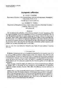
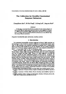
MATERIALS AND METHODS Study Location The first-order stream monitored by this study (Fig. 1) flows through a forested riparian wetland that is fed by groundwater contributions from surrounding upland agricultural fields (Angier et al.,2005). The contributing watershed is 70ha, with approximately 75% in agricultural row crop production and 15% in upland deciduous forest and fallow meadows. The stream is bounded along its entire length (~1100m) by a forested riparian corridor (red maple canopy with herbaceous wetland understory) that occupies about 10% of the total watershed land area. Agricultural fields in the upland are bordered by a narrow strip of grass and forest, after which an elevation drop of several meters runs down to a central forested wetland corridor. The riparian wetland varies in width from 60 meters at its narrowest point to more than 250 meters at its widest, and is drained by a shallowly incised streambed averaging 1m wide and 60cm deep. Topography is flat, with a slope of 0.7% over the course of the stream. The poorly drained riparian histosols (Typic Haplosaprist) found in the wetland are approximately 2m deep, and are underlain by an oxic sand aquifer that discharges groundwater received from the upland (McCarty and Angier, 2000). Increased oxidation (decreased redox potential measured with Pt electrodes, data unpublished) was observed at depth in one central groundwater discharge area following 20cm of rainfall deposited by a tropical depression (Oct. 6-8, 2005), suggesting a rapid transport time from the upland through preferential flow pathways. This finding supports previous work that has identified preferential groundwater flow pathways in the surrounding agricultural fields (Gish et al. 2005). Spatial heterogeneity in the wetland is high, as is obvious from the uneven distribution of groundwater upwelling zones, and previous research has discerned distinct differences in bulk density, hydraulic conductivity, and other parameters occurring over distances as small as five meters (McCarty and Angier, 2000; Angier et al., 2005). Fertilizers and manure products applied to the agricultural fields provide a source of nutrients (nitrogen and phosphorus) found in surface and ground water within the riparian zone. Pesticides applied to the fields are also detected in the riparian zone and stream. Average annual precipitation is 87cm, with base flow accounting for about 65% of total annual stream flow. Stream flow characteristics and groundwater discharge patterns are highly variable in this system, with stream flow ranging over five orders of magnitude. Evidence collected from storm events indicated that stream nitrate flux was typically lower during runoff conditions and increased as groundwater contributions represented a greater proportion of post-storm stream discharge (Angier et al., 2005). Conversely, phosphorus and sediment contributions were greatest during storm events. Weir Design and Calibration The stream was instrumented with five permanent monitoring stations, each consisting of a constructed weir with associated sampling equipment, that effectively divided the stream into four sections that could be analyzed independently (Fig. 1). Immediately upstream from each station the stream banks were armored using tarps, cinder blocks, and cemented sandbags, to create a smooth approach and to prevent the stream from undercutting or bypassing the monitoring structures. The flow was subsequently routed through a trapezoidal stainless steel approach channel (2.4m length, 0.8m height, 0.9m width at base, 1.2m width at top) terminating in a face plate attached to the outlet that defined a combination V-notch / Cipolletti weir (Fig. 2). Each V-notch was 15cm deep, with the apex located 3cm above the channel bottom. The V-notch angle ranged from 60o at upstream locations (Stations 1 & 2) to 90o (Stations 3 & 4) and 120o downstream (Station 5), to accommodate increased baseflow volumes in the lower reaches resulting from groundwater upwelling and increased contributing area. The 1.0m crest of each Cipolletti weir began at the top of the V-notch, 18cm above the channel bottom, and the Cipolletti shape followed the sides of the structure to a maximum height of 62cm above the crest, at which point the width was 1.2m. The weirs were designed such that under baseflow conditions and during small events flow passed through the V-notch (Fig. 3a). During sizeable rainfall-runoff events the V-notch was filled and the Cipolletti portion of the weir came into play (Fig. 3b). On occasions of extreme flow (e.g., following prolonged heavy rainfall from tropical depressions) the stream overtopped its bank and flooded the wetland, in which case the weirs were bypassed. A rating curve was established for each station based on multiple stream flow measurements collected over a broad range of flow conditions. For the V-notch stage flow was captured in a calibrated 20l bucket. For the Cipolletti stage (storm flow) it was not possible to capture all flow, and instead surface velocity measured with a floating object was multiplied by cross-sectional area to estimate total flow (use of a flow meter at 0.6 depth was found to be inferior to the float test in this case). In both cases water level was measured
Hydrologic Science and Technology 2006:22(1-4):71-82. directly with a meter stick and time was measured with an electronic stopwatch (recorded in 0.01s increments). V-notch measurements were made at all stations. Cipolletti stage measurements were made only at Station 3. Rating curves were developed by fitting power equations to the measured data using SigmaPlot software (Systat, 2004).
Location of Monitoring Stations The five monitoring locations were selected based upon channel morphology (where construction was feasible) and adjacent riparian zone and upland characteristics (see Fig. 1). Station 1 drained the uppermost, zero-order, non-agricultural-impacted portion of the system. Flow at this station was intermittent, occurring mainly during winter and following large storms. Measured stream nitrate concentrations at this location were always consistent with background, non-agriculturally-influenced water sources (< 1 mg/l N, Lowrence et al., 1996), reflecting the characteristics of the undeveloped forested area that it drained. Station 2, located 105m downstream from Station 1, marked the first monitoring point for agricultural influences. This part of the channel functioned as the stream headwater during dry periods, as water flowed continuously here even in drought conditions. Station 3, located 154m below Station 2, drained a part of the riparian zone identified as a perpetual wetland (based on hydrological characteristics and vegetation) that received the bulk of local groundwater upwelling from the adjacent agricultural area. Station 4, located 346m downstream of Station 3, was bordered by a portion of the riparian zone that exhibited intermittent wetland conditions. Station 5, located 449m below station 4, marked the terminus of the study area, just above a juncture with a higher-order stream channel. At this location the stream overtops its channel during periods of high flow and occupies a comparatively large flood plain, so Station 5 was not considered to be accurate under high flow conditions. Each station was instrumented with an autosampler (Sigma 900MAX Portable Sampler, American Sigma, Loveland, CO, USA) fitted with an ultrasonic detector (Sigma 950/960 Ultrasonic Flow Meter) that continuously measured and logged water height 60cm upstream from the weir (10-minute logging interval). Stream water samples were collected by hand during baseflow and by autosampler during event flow. Over the course of five years of monitoring baseflow conditions prevailed 87% of the time and accounted for 65% of total stream discharge. Additional detailed description of the riparian system is presented in Angier et al. (2005). Scale Model Evaluation In addition to in-situ measurements, weir dynamics were evaluated using a 1/5 scale model of the weir structure. The scale model was attached to a 5m long steel approach flume of similar dimensions (1% slope) into which water was pumped at varying rates. Flow from the weir was captured in buckets and measured in graduated cylinders, with time measured with a stopwatch and head measured with a ruler. Each of the V-notch angles (60o, 90o, 120o) was evaluated in this manner, along with the corresponding Cipolletti stage.
RESULTS AND DISCUSSION Calibrating the stage-discharge equation for each of the five weirs required taking detailed stream water velocity and height measurements over a wide range of flows (baseflow to bank full) and appropriate field conditions had to be met to obtain these data. The full range of measurements was obtained over the course of a two-year period (1999-2000). A total of 185 V-notch-stage measurements and 10 Cipolletti-stage measurements were collected during this calibration period. Weir Power Equations Theoretically, flow through a weir (Grant and Dawson, 1995) conforms to: Q=KHx
[1]
where: Q = discharge (l/s) K = constant describing the water entry coefficient (dependant on weir shape), the dimensions of the weir structure, and unit conversion, among other factors H = height of water (cm) measured from the apex of the V-notch or from the crest of the Cipolletti weir x = power theoretically equal to 2.5 for V-notch and 1.5 for Cipolletti weirs Discharge from a combined weir is expected to be additive, although the effects of compound weirs have rarely been thoroughly investigated (Grant and Dawson, 1995). V-notch weirs For V-notch weirs, K can theoretically be decomposed into:
Hydrologic Science and Technology 2006:22(1-4):71-82. K = Cd 8/15
2 g tan(notch angle/2)
[2]
with Cd approximating 0.6. Best accuracy is obtained for V-notch weirs when 6cm < H < 38cm. For all of the weirs, notch height above the approach channel was 3cm, which is less than the minimum recommended height of 6cm. Although the flat topography required this compromise, with the associated risk of excess influence of frictional forces during low to moderate V-notch stages, calibration of the weirs on a site to site basis was expected to compensate. Under low and moderate flow conditions (e.g., Fig. 2a) the nappe was generally well separated from the V-notch weir face (well-aerated) except under near-dry conditions when flow was negligible. Depending on the season and the amount of downstream channel blockage some ponding occurred below the weir outflows during moderate and high flow events (e.g., Fig. 2b), particularly at Stations 1, 4, and 5. Submersion of the outflow of a weir is expected to lead to overestimation of discharge due to reduced flow velocity. However, individual weir calibration based on measurements collected through the full range of observed flow can help to compensate for these factors. V-notch flow was calibrated separately for each notch angle (data from 60o Stations 1 & 2 were combined, and data from 90o stations 3 & 4 were combined) and for each individual weir (Table 1). Flow measurements and resulting rating curves are presented in Figure 3. Measurements made at Stations 1 and 2 diverged in the upper V-notch stage (Fig. 3a), perhaps due to ponding below the outlet of Station 1 that was observed to occasionally submerge of the base of the V-notch. Results derived from measurements made at Stations 3 and 4 were more consistent (Fig. 3b), although Station 3 appeared to produce more flow for a given water height in the upper range of the notch. Again, this result may be attributable to ponding below the outflow, which was observed to occur more frequently at Station 4. Overall, the measured flow data were fit quite well by the weir power equation Eq. [1] (R2 = 0.97 to 0.98). If the data were fit leaving the exponent x unconstrained, values for x deviated from the expected value of 2.5, ranging from 2.29 to 2.64 (Figure 3), Apart from natural variability inherent in data measurement., the observed x values likely reflect the influence of non-ideal weir construction parameters, namely a small minimum notch height (y) above the stream channel and a small minimum fall below the outlet, Indeed, deviation from the expected equation was greatest for Station 5 (x = 2.295; Figure 3c), where submersion of the base of the V-notch was most common due to occasional ponding below the outlet during moderate winter flows, If the exponent x was constrained to theoretical value of 2.5, the coefficient K showed a regular increase from 0.01 (60o) to 0.016 (90o) and 0.024 (120o), reflecting the increased discharge through the wider V-notches. There was no significant statistical difference between rating curves developed with x constrained vs. unconstrained, and it was therefore decided that the equations developed with x = 2.5 were superior, since these were expected to hold true over the entire range of the V-notch and to reflect less variability attributable to measurement error. Cipolletti weirs For Cipolletti weirs, K can theoretically be decomposed into:
2g L
[3]
Cw = 0.4 + 0.05 H/y
[4]
K = Cw 2/3 where:
For the Cipolletti stage of the compound weir, y = 18cm, and Hmax = 62cm, yielding a Hmax/y ratio of 3.4, somewhat in excess of the optimum of