Boivin, Coates, Werle and Baird
Remote Sensing Applications for Large River Fisheries
Remote Sensing Applications for Information Generation and Monitoring of Large River Fisheries . Thomas Boivin 1, David Coates 2 , Dirk Werle3 and Jason Baird 1 1
Hatfield Consultants Limited,
[email protected]
201-1571
Bellevue
Avenue,
West
Vancouver,
British
Columbia,
2
World Bank/GEF Component of the Fourth Fisheries Project, Dhaka, Bangladesh
[email protected]
3
AERDE Environmental Research, Halifax, Nova Scotia, Canada
[email protected]
Canada.
V7V
1A6.
ABSTRACT
Taking reviews of information needs for large river fisheries as a starting point, an analysis is made of the areas where remote sensin g has a proven or potential role. Remote sensing approaches can be very cost effective, especially as a large library of relevant data and images has already been obtained for many areas of the globe. Much of these data can be accessed free of charge via the internet. The main requirement for sustaining and protecting river fisheries is improved management and rehabilitation of the environment. The ability to cost effectively obtain information on aquatic and terrestrial environments wit hin river basins, for both resource assessment and monitoring purposes, is the most prominent and widely proven application of remote sensing in this field. Combining remote sensing /earth observation data with population distribution data and other secondary sources of information, in a GIS framework, can generate useful tools for assessing the interplay between environmental, economic and social aspects of fisheries. This includes yielding information on the status of fisheries habitats, dependency of people on aquatic resources, and their vulnerability to environmental change – all vital planning information. Other relevant applications of remote sensing include assessment and monitoring of wetlands, flooding, biodiversity, dry season refuges, vegetation and fisheries activities . For most applications, cheap or even cost free data are often adequate. Other modern remote sensing approaches now offer remarkable levels of accuracy and resolution, but are still cost effective for localised applications. Generally, the constraints with remote sensing are not in the technology or cost , but in its application. Remote sensing specialists generally are not sensitive to the information requirements for inland fisheries in tropical river basins. Equally, many inland fisheries specialists are not fully aware of the possibilities available through remote sensing. Many people have difficulties viewing inland fisheries in geo-spatial terms. The problems are exacerbated by the gulf in information requirements and management objectives for large rivers between the developed and developing countries , which leads to a discrepancy of needs, capacity and expertise. Only when these gaps are bridged will the full potential of remote sensing for river fisheries in tropical developing countries be fully realised.
1
Address for Correspondence: Hatfield Consultants Limited, 201-1571 Bellevue Avenue, West Vancouver, Canada. V7V 1A6. Telephone: 1-604-926-3261; Fax: 1-604-926-5389. E-mail:
[email protected]
1
Boivin, Coates, Werle and Baird
Remote Sensing Applications for Large River Fisheries
Running Title: Remote Sensing Applications for Large River Fisheries Key Words: Remote Sensing, GIS, Mekong, Wetlands, Monitori ng, Environment
2
Boivin, Coates, Werle and Baird
Remote Sensing Applications for Large River Fisheries
ACKNOWLEDGEMENTS
The authors would like to thank the following persons and organizations for their assistance with preparation of this paper: Aneeqa Syed, Sue Stanley, Grant Bruce, Achmad Kosasih, Martin Davies, Garth Taylor, Firman Setiabudi, and Pierre Dubeau of the Hatfield Group; Joern Kristensen, Pech Sokhem, Ian Campbell, Hans Guttman, Phin Sopheap, Hideto Fujii, Manithaphone Mahaxay and Penroong Bamrungrach of the Mekong River Commission ; JeanMarc Chouinard, Denis Auger, Cristobal Colon and Thomas Piekutowski of the Canadian Space Agency; and, Irwin Itzkovitch, Bob Ryerson, Marc D’Iorio, Joost van der Sanden and Mario Beauchemin of Natural Resources Canada (Canada Centre for Remote Sensing ; CCRS). RADARSAT -1 and other remote sensing data were provided under projects funded by the Canadian Space Agency/CCRS and the Mekong River Commission Secretariat. Special thanks is also given to: Bill Kemp, Caroline Kemp, Cesare Tatarelli, Stephanie Beck, Robin Welcomme, David Dudgeon, Niek van Zalinge, Peter Degen, Dirk Vanderstighelen, Gordon Rigby, Adrian McCardle, Yves Crevier, Malcolm Winsby, Alan Stockwell, Chris Hatfield, Wayne Dwernychuk, Jeffrey Himel, Stephanie Beck and San Sarana. Finally, we would like to thank our friends and colleagues in Cambodia, Viet Nam, Lao PDR and Thailand for their assistance and collaboration on our project work in the Mekong riparian countries .
3
Boivin, Coates, Werle and Baird
Remote Sensing Applications for Large River Fisheries
INTRODUCTION Background
Remote sensing can be defined as the science, technology and art of obtaining informati on about objects or phenomena from a distance (i.e., without being in physical contact with them). In this paper , we refer specifically to the remote observation of the earth’s surface features, as well as natural phenomena and human activities that can be seen from afar . Emphasis is placed on proven applications of remote sensing and earth observation tools for information gathering and monit oring of fisheries habitats and natural resources in tropical developing countries . Since the beginning of time, man has used simple methods of remote sensing to assist in the capture of aquatic animals, and to monitor their movements and migration patterns (e.g., observations of schooling fish in river pools from high ground, spotting breaching or spouting whales in the ocean from ship’s look-outs, etc.). The use of aerial remote sensing in earth observation has a long history, starting with the invention of hot -air balloons by the Montgolfier brothers in France in the late 1700’s. Over the past century and a half , the invention and sophistication of photography was another major leap forward , and coupled with the rapid development of flight , led to great advances in what is now termed aerial photography. It is worth mentioning that these techniques still offer considerable advantages for low-cost surveys of localised areas, particularly with the development of lightweight digital cameras, transmitters and small remote-controlled aircraft. Remote sensing technology offers a number of important advantages over the subjective view of the human. It provides a synoptic (large area, all-at-once) view of the earth’s features from a bird’s-eye perspective. With the development of modern satellite sys tems, and improvements in image transmission and ground receiving station technology , remote sensing imagery can now be obtained rapidly and repeatedly over large areas. For this reason, remote sensing has bec ome an integral part of most resource mapping and inventory procedures (See: CCRS ‘Remote Sensing Glossary’ www.ccrs.nrcan.gc.ca). The Cold War period gave rise to the rapid development and deployment of space-based satellite systems, originally and primarily for military applications and weather forecasting. The American Corona and Keyhole satellite imagery of the 1960s has been de -classified and represent potentially useful historic data sets. Beginning with the launch of the first Earth Resource Technolo gy Satellite ERTS-1 in 1972, later called Landsat-1 to 7, the range of observation, resolution and availability of modern Earth observation technologies has steadily increased over the past three decades . The French SPOT system spearheaded commercial applications since the mid-1980s, while other European sensors, such as ERS -1 and 2 as well as the Japanese JERS -1, offered innovation in radar imaging during the 1990s (albeit only in an experimental mode). The commercialisation of satellite radar imagery commenced with the
4
Boivin, Coates, Werle and Baird
Remote Sensing Applications for Large River Fisheries
launch of the Canadian RADARSAT -1, a versatile system capable of providing weatherindependent, high-resolution data products in near -real time to the user. The availability of satellite data in digital form and the development of inexpensive high -speed computers and image analysis software offered a path for the practical, cost-effective use of these data and technology. The increasing number of satellite image sources, particularly those with high spatial, spectral and temporal resolution (e.g., IKONOS, Hyperion and MODIS), has made possible remote sensing of any lo cation on the Earth's surface. Technical innovations in the analysis of data and its integration with such tools as geographic information systems (GIS) have made remotely sensed data ubiquitous in the management of natural resources. The growing commercial availability of a multitude of satellite technologies , data archives, and professional expertise has fostered the rapid growth of a viable remote sensing industry since the mid-1980’s. This has led to the increase in opportunities in developing tropical countries for assessing, monitoring and managing environmental challenges such as watershed and land-use change , flood management and fisheries monitoring. Table 1 presents a selection of satellite remote sensing tools suitable for the analysis of inland waters, and also summarises the qualities of these sensor systems in terms of their spatial, spectral and temporal resolution. The table answers the following key questions regarding some of the most common remote sensing satellite systems: a) What is the smallest detail that they can ‘see’, and how much area on the ground is covered by an individual image? b) How well can they detect and separate different spectral ‘signatures’ of the Earth’s surface? c) How often can a particular satellite sensor ‘revisit’ a particular area on the ground for monitoring purposes? Each of the above questions has important implications for the selection of the most appropriate remote sensing imagery for a specific aquatic appli cation. (Insert Table 1)
Information Needs for Large River Basin Fisheries
The FAO (2000) concluded that, whilst most rivers are heavily or over-exploited, the major threat to sustaining river fisheries is loss of the quantity and quality of habitat. This places a large emphasis on information requirements in the environment arena. Coates (2002) reviewed current statistical systems and information needs for inland fisheries in South-East Asia and noted serious discrepancies between information requirements and information generation . The review echoed the need for greater emphasis on environmental aspects of inland fisheries management, and called for improved information systems to monitor biodiversity, livelihoods and other socio-economic aspects of these fisheries. An assessment of information, knowledge and policy requirements for large rivers was undertaken collectively at the Second International Symposium on the Management of Large
5
Boivin, Coates, Werle and Baird
Remote Sensing Applications for Large River Fisheries
Rivers for Fisheries: Sustaining Livelihoods and Biodiversity in the New Millennium (Coates et. al. 2003; in press). The symposium demonstrated that fisheries information requirements are diverse and complex, and differ throughout the management and policy spectrum. Policy and management needs should steer information generation, and not vice versa. All too often, information generation is driven by s pecialised interests and does not always address management priorities. The impact of information on policies for river fisheries is also a complex subject (Hirsch 2003; in press). In order to protect and conserve fisheries resources in large river basins for future generations, it is essential that local fisheries managers have access to up-to-date information and cost-effective tools for monitoring changes in fish habitat, fishing activities and potential impact sources. As a tool, remote sensing data can make a substantial contribution for monitoring fisheries habitats and wetlands , and also provide complimentary information on land-use, weather patterns, flood events and related environmental parameters. Against this background we review remote sensin g applications in river fisheries and highlight some successes, opportunities and needs. A REVIEW OF REMOTE SENSING APPLICATIONS RELEVANT TO RIVER FISHERIES Wetland Classification
Wetlands are vital in flood management and the maintenance of water quality. They are also the supporting environments for river fisheries, and to a large extent also for aquaculture. Wetland mapping, monitoring, and delineation are amongst the most widespread applications of remote sensing in this subject area. Some examples include the use of various remote sensing technologies, such as multi-sensor approaches to wetland flood monitoring (Toyra, Pietroniro, Martz & Prowse 2002), assessing aquatic habitats of the Mekong Basin (Boivin, Coates, Levy & van Zalinge 2000), and generating databases to inventory seasonal water variation and aquatic vegetation status (Chopra, Verma & Sharma 2001). Added to this are the even more widespread applications of remote sensing to watershed monitoring and mapping, including land-use. For wetland mapping, whilst remote sensing of open waters is relatively easy, a major requirement is to be able to discriminate aquatic habitats with a high degree of vegetation cover (Boivin and Werle 2003; in press). Ozesmi and Bauer (2002) combined radar and optical data to improve wetland classification. Bourgeau-Chavez, Kasischke, Brunzel, Mudd, Smith & Frick (2001) discuss the limited use of optical remote sensing to detect flooding beneath emergent vegetation and forest canopies. Other problems that have been examined include classification techniques and proper separation from other land cove r types (Dwivedi, Rao & Bhattacharya 1999), and reducing the speckle effects of RADARSAT by applying spatial filter treatment to data (Rio and Lozano -Garcia 2000). Within the context of the Mekong basin, the Mekong River Commission (MRC) is expanding the current knowledge base and exploring remote sensing approaches to environmental
6
Boivin, Coates, Werle and Baird
Remote Sensing Applications for Large River Fisheries
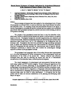
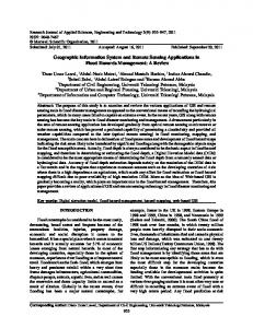
monitoring and management of wetlands of the Lower Mekong River , particularly in Cambodia and the Mekong Delta in Viet Nam . Recent work by Hatfield Consultants and the MRC (unpublished data) demonstrated that critical wetland and aquatic habitat features in the Tonle Sap floodplain could be effectively identified and classified using RADARSAT -1, LandSat, AIRSAR and other satellite imagery in conjunction with other data sources. Successful delineation of Cambodian wetlands and important fisheries habitats such as seasonal ponds can be readily achieved through the complementary use of remote sensing and ground reference data, as illustrated in Figures 1 and 2. Flood Management
Floods are often considered to be one of the most im portant natural disasters leading to devastating effects on both land use and its inhabitants. However, natural flooding is essential to both agriculture and fisheries in large tropical rivers , including the Mekong (Mekong River Commission and Hatfield Consultants Ltd. 2003). Damaging floods, more correctly ‘catastrophic floods ’, are those that extend beyond natural or anticipated limits. ‘Flood management’ in the Mekong includes not only concepts of flood ‘control’ and ‘protection’, but also includes understanding the natural ecological and economic benefits of annual flooding. Determining the extent and duration of a flood event is crucial to understanding the hydrological regime of a watershed. In catastrophic events, this understanding can lead to better deployment of relief efforts, as well as proper assessments of damaged areas. The majority of the remote sensing literature related to flooding focuses on the use of differing technologies to better map flood inundation areas and standing water. The most successful of these applications combine multiple datasets and imagery. These range from JERS-1/SAR imagery (Yamada, Sakurai-Amano & Takagi 2002), to MODIS 250m data (Zhan, Sohlberg, Townshend, DiMiceli, Caroll, Eastman, Hansen & DeFries 2002), to timeseries AVHRR (Bryant and Rainey 2002; Sheng, Gong & Xiao 2001). Applications of remote sensing to areas such as floodplain habitat characterization (Shimabukuru, Novo, Melack & Mertes 1998; Wang, Colby & Mulcahy 2002), flood boundary delineation (Ratanavong 1998; Werle, Martin & Hasan 2000; Horritt, Mason & Luckman 2001), and detecting seasonal flooding cycles in marshes (Pope, Rejmankova, Paris & Woodruff 1997) have also been developed in various experimental settings . Other areas of research include combining SAR data with GIS techniques to better delineate inundation areas (Brivio, Colombo, Maggi & Tomasoni 2002), to flood monitoring and damage evaluation (Liu, Huang, Li & Wan 2002), and using multi-sensor assessments such as SAR/VIR satellite imagery to map standing water extent (Toyra, Pietroniro & Martz 2001). Inundation areas in the Lower Mekong Basin have been successfully mapped over the past 4 years to aid the development of a Regional Flood Management and Mitig ation Strategy ( MRC and Hatfield Consultants, unpublished data). The study showed that the integration of remote sensing and other data sources could be used to assist regional water managers and disaster relief specialists to deal with major flood events. The approach utilized remote sensing and
7
Boivin, Coates, Werle and Baird
Remote Sensing Applications for Large River Fisheries
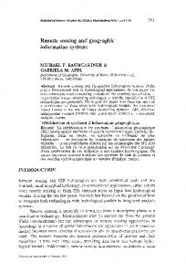
GIS data to generate inundation maps based on satellite imagery, background environmental data, and ground truthing, and demonstrated a timely imagery dataset that quantified flooding extent in the Mekong Basin at various times of the hydrological cycle (Figure 3). Rosenqvist and Birkett (2002) provide an instructive example of radar remote sensing within the Congo River basin in Africa. They used dry and wet season mosaics (1200 x 1300 km) of the Japanese JERS -1 imaging radar to validate seasonal flood dynamics of the entire basin. Rosenqvist and Birkett (2002) also measured flood levels of the river by utilizing satellite altimeter data that are capable to provide de tailed readings within 10 to 20 cm accuracy for water level changes between different satellite overpasses. The use of precision altimeter data for seasonal and inter-annual water level monitoring of large lakes and rivers has been successfully demonstrated by Birkett (1998) . Given the diminishing network of lake and river level gauges in many tropical countries, the author suggested that altimeters of the TOPEX/Poseidon and Jason-1 satellite missions could potentially be used as an alternate source for monitoring purposes . The motivations for applying remote sensing to flooding have often been driven by interests that consider flooding in a rather negative light (e.g., as a disaster or as an opportunity to convert seasonal wetlands into ‘improved’ uses). Even so, the data and information sources that emerge have considerable applications to fisheries, not least because of the important relationships between flooding events and fisheries ecology and production (Mekong River Commission and Hatfield Consultants Ltd. 2003). Remote sensing data are a major, if not the main, information resource for examining the potential impacts of water resources management on fisheries in floodplain river ecosystems. The use of these approaches to improve fisheries directly, through pro-active management of flooding events to benefit fishery resources, is an area of considerable potential but one that requires a holistic vision of water resources management. Biodiversity Monitoring
The total biodiversity of an ecosystem, such as a watershed or lake, has traditionally been estimated using conventional techniques such as field sampling and surveying of fragmented areas. Remote sensing applications have increased the ability of conservation specialists to assess large geographic areas thoroughly and conduct inventories of plant and animal species richness and abundance. A common theme among scientific reports that explore the relationship between mapping biodiversity and remote sensing point to the fact that the most effective way of achieving this is through the combinat ion of field work and satellite imagery (Fuller, Groom, Mugisha, Ipulet, Pomeroy, Katende, Bailey & Ogutu -Ohwayo 1998). Many of the published reports describe the use of remote sensing techniques such as Landsat TM coupled with GIS for asses sing species diversity (Nagendra 2001; Oindo, Skidmore & De Salvo 2002). Biodiversity characterization through integration of remote sensing and geospatial modelling (Roy and Tomar 2000) also shows potential. By integrating field surveys
8
Boivin, Coates, Werle and Baird
Remote Sensing Applications for Large River Fisheries
with remote sensing, biodiversity can be effectively mapped, therefore promoting conservation and preservation of sensitive species and areas. An important element of biodiversity is ecosystem complexity. At the regional scale level of 1:50,000 and larger, satellite remote sensing offers considerable potential in classifying, assessing and monitoring the geo-spatial dimensions of this complexity. This is especially the case when used in conjunction with assessments of temporal changes in ecosystems (such as flooding) both within (seasonally) and between years. Remote sensing also offers considerable promise for measuring ‘connectedness’ between different parts of aquatic ecosystems (e.g., longitudinally along a river course, laterally between the river a nd floodplains) that is a crucial element in maintaining ecosystem health (Boivin et al. 2000; Mekong River Commission and Hatfield Consultants Ltd. 2003). Coates (2001) also noted the intimate linkages between biodiversity, livelihoods and fisheries in tropical rivers. The role of remote sensing in biodiversity management and conservation is also, therefore, directly linked to sustaining the economic benefits of river fisheries and achieving sustainable development. Identification of Dry Season Refuge s
Dry season refuges are areas such as dry season pools on floodplains, or deep pools within rivers, that form the natural refuge for aquatic animals and plants after floods have receded. They are the source of recruitment onto floodplains at the beginning of the flood season , and essential to maintaining life cycles, and hence both fisheries production and biodiversity (Mekong River Commission and Hatfield Consultants Ltd. 2003). Due to the intensifying use of floodplains for agriculture in the dry season, and the increasing demands on dry season water resources, these refuges are being severely reduced in size and number , and are highly degraded in quality in heavily populated areas . The location, distribution, size and number of dry season refuges are all important factors determining the health of river ecosystems and sustaining production from fisheries. Remote sensing approaches present one of the most effective methods of assessing and monitoring these factors as a basis for developing appropriate management policies (see Figures 1 and 2). Aquatic Vegetation Mapping/Inventorying
Vegetation mapping is an important tool that can be used to assess and evaluate ecosystem health in order to develop and sustain fisheries resources. A combination of field surveys and remote sensing are again imperative to successfully mapping aquatic vegetation distribution. Areas of research that have been examined include the integration of RADARSAT an d JERS-1 images as they apply to the mapping of aquatic vegetation in the Amazon river basin (Costa, Niemann, Novo & Ahern 2002); as well as integrating GIS and remote sensing to evaluate how aquatic vegetation affects local fish populations (Li, Huang & Li 2002). Harvey and Hill (2001) discuss the advantages of certain satellite imagery over others in mapping tropical environments, while Groten and Ocatre (2002) discuss using remote sensing to monitor the
9
Boivin, Coates, Werle and Baird
Remote Sensing Applications for Large River Fisheries
length of the growing season. Pal and Mohanty (2002) studied change detection in aquatic vegetation as it relates to water quality. Overall, the use of remote sensing technologies to map and inventory aquatic vegetation and biophysical characteristics of floodplains has met with considerable success, leading to better understanding of growing season lengths, affects on native fish populations, and water quality issues. Fisheries Monitoring/Management
Coates (2002) noted that, together with GIS approaches, remote sensin g was a cost-effective means of making rapid assessments of inland fisheries compared to developing costly, and often inefficient, information systems based upon the collection of statistical data throug h classical survey methods. Coates (2002) also noted that inland fisheries can be described within an acceptable limit of tolerance by using basic information on the quality and quantity of aquatic resources, the distribution of human populations in relat ion to those resources , and the level of economic development (and other socio-cultural variables). Most of these requirements can be met through utilising remote sensing data. Data on human populations, and socio-cultural information, can usually be easily obtained, digitised and combined with remotely sensed data in a GIS framework. The approach gives a far more accurate assessment of the extent and estimated value of inland fisheries than methods currently employed. The effective management of fisheries resources can be improved through the use of remote sensing applications. Initial studies have been carried out that examine the applications of remote sensing technologies to fish and fish habitat (e.g., Santos 2000; Boivin et al. 2000; Whited, Stanford & Kimball 2002). The integration of GIS and remote sensing applications to the field of inland fisheries management has important im plications for the assessment of resource potential, fish abundance and distribution, and habitat classification (Welcomme 2001). Boivin et al. (2000) used remote sensing data to record and map fish habitat in the Great Lake and Tonle Sap River basin in Cambodia, including permanent and seasonal water bodies, fishing structures, aquaculture ponds and fishing activities. The study provided baseline information for fisheries management and natural resources planning in a broader multi-use context. Recent research on evaluating potential primary production of ocean currents as it relates to chlorophyll concentrations (Carr 2002; Solanki, Dwivedi & Nayak 2001) have relied extensively on remotely sensed data. These studies have concluded that areas of high chlorophyll content may be areas of higher fish presence and productivity. Such approaches have potential applications for open waters in inland areas (e.g., large lakes and reservoirs). Studies of fish productivity as it relates to seasonal flooding (Puckridge, Walker & Costelloe 2000) have improved our understanding of ecological applications of remote sensing data. A major role for remote sensing lies in its ability to cost -effectively monitor aquatic environments and, hence, the resource base of the fishery. Coates (2002) noted the urgency
10
Boivin, Coates, Werle and Baird
Remote Sensing Applications for Large River Fisheries
for development of improved monitoring systems to assess environmental change in river fisheries. In fisheries management, it is essential to be able to disaggregate the impacts of fishing effort and environmental change in order to adjust management responses accordingly. This requires the recording of baseline data on natural variations in the environment, for example flood extent and distribution and area of dry season refuges. The relevant trends then need to be tracked over time in order to interpret real or potential responses in the fisheries. Remote sensing is a particularly useful monitoring technique, because it can cover large areas cost -effectively and data can be quickly and easily obtained and stored for future reference. It is therefore recommended that fisheries data requirements should be included in broader planning activities for remote sensing data acquisition amongst government and research agencies . Constraints to Use of Remote Sensing
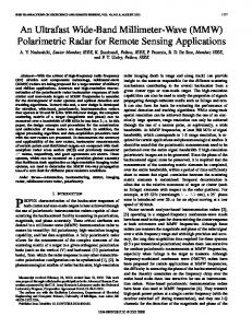
The technical constraints to remote sensing are gradually eroding as systems become much more accurate and reliable. Potential applications are also increasing as technologies provide ever-improving sensor resolution. Many sectors are increasing their use of remote sensing and GIS tools, which has resulted in rapidly expanding services at the public, academic and commercial levels. The advent of the Internet has also greatly increased access to remote sensing data and information (see Figure 4). The major constraints with the application of remote sensing to river fisheries concern human resource issues and, in some cases, sheer data volume. Coates (2002) has generalised that inland fisheries scientists have been constrained by th e historical development of fisheries research, development and management, which has been driven mainly by marine fisheries and commercial aquaculture interests. He argued for new approaches pointing to the need to develop tools specifically designed for the needs of the inland fisheries sector, particularly for rivers. This requires that classical management approaches which focus on fish stocks and the need to control effort (the primary approach for marine fisheries) be de-emphasised. ‘River fisheries science’ needs to re-allocate effort to a more holistic view of river fisheries management, where the important roles of environment, biodiversity and livelihoods considerations, and their inter -linkages, take a higher profile. As outlined above, it is in the latter areas where remote sensing not only has a proven record of success, but also shows considerable potential for wider application. An urgent need is to both raise awareness and build capacity to meet these opportunities amongst river fishe ries scientists and managers, particularly in developing countries. Two main areas need attention. First, for fisheries specialists to be better trained regarding remote sensing (and GIS) applications. The greatest challenge is to get specialists to think holistically about their fisheries, taking on board, for example, adequate attention to environmental management, and the need to be able to think spatially about fisheries. Second, for remote sensing and GIS specialists to be better informed of th e information needs for river fisheries management and the potential applications of their expertise. It is not
11
Boivin, Coates, Werle and Baird
Remote Sensing Applications for Large River Fisheries
necessary, nor even desirable, for either group to switch specialisations. But, improvements in coordination will undoubtedly lead to consider able advances. Part of the needs can be met through information packages that help describe river ecology in a way that fosters improved communication and understanding between specialists with different backgrounds. For example, recent river ecology training materials produced for the Mekong River Basin (Mekong River Commission Secretariat and Hatfield Consultants Ltd. 2003) are aimed specifically at this need, and are based partly on sources of information produced with the help of remote sensin g. Added complications are the great differences in fisheries management priorities for large rivers between developed and developing countries. Food production, food security and livelihoods considerations dominate the latter , and recreational uses and environmental protection the former (Welcomme 2001). The rivers themselves also differ significantly between temperate and tropical areas. Most river basins in developed countries are already so intensively regulated that their ecology differs significantly from that of natural systems. This can bring with it constraints on the abilities of remote sensing/environmental specialists from developed countries to be fully effective in transferring this technology to developing country situations. The financial costs of remote sensing data acquisition vary considerably depending on either public or commercial satellite operations, the timeliness of data delivery, the spatial detail or resolution of the imagery, and also on the application in question. All too often, the costs are regarded as being excessive, without undertaking a comprehensive analysis of options or cost-benefits. In many cases, suitable remote sensing data already exist in countries and are available for use without cost, or for a nominal fee, that is based on the cost of data reproduction. These data are often gathered and stored by a variety of dispersed institutions. The development of common databases and storage systems fo r sharing remote sensing resources is urgently required in many countries. A considerable amount of data and information is also available, free of charge, from the internet (Figure 4). Major space agencies in North America and Europe maintain remote sensing archives with useful ‘quicklook’ displays of actual imagery. For fisheries purposes, the acquisition of new remote sensing data is often best achieved by coordination with other agencies that are often far better resourced in this respect. In this process, adequate inclusion of fisheries needs into image acquisition and dissemination programmes is critical. The costs of alternative sources of information should also be borne in mind. More traditional approaches, for example ground-based fisheries surveys, can be inordinately expensive in terms of manpower requirements for data gathering, storage and analysis. There is significant opportunity for using remote sensing and GIS approaches for fisheries assessments in inland areas in cases where alternative sources of data are lacking or unreliable , or where existing information systems are not only expensive but produce inappropriate and unreliable data (Coates 2002).
12
Boivin, Coates, Werle and Baird
Remote Sensing Applications for Large River Fisheries
CONCLUSIONS
Successful applications of remote sensing to river fisheries management are already well documented. Optimising the benefits of remote sensing will rest not in technological advances, which are already great, but in shifts in approaches to information requirements for river fisheries and the development of information systems that will fulfil those needs. Awareness raising and capacity building at relevant levels will contribute significantly to achieving the necessary progress. Policy makers are ultimately interested in economic and social, not biological, aspects of fisheries. Regarding likely new ‘advances’ in the application of remote sensing, it is the bridging of the natural and social sciences that offers the most promise. For example, combining remote sensing environment data with population distribution data (and other secondary sources of information) in a GIS framework can yield information on the status of fisheries, dependency of people on aquatic resources and their vulnerability to environmental change – all vital planning information. This approach requires the realisation that, particularly in rivers in developing countries, the physical and natural world has a great bearing on the livelihoods of people (and vice versa). Remote sensing and GIS provides not only a ‘picture’ or a map-like representation of those links, but also the tools for analysing their spatial and temporal dimensions . REFERENCES
Birkett, C.M. (1998) Contributions of the TOPEX NASA altimeter to the global monitoring of large rivers and wetlands. Water Resources Research 34, 1223-1239. Boivin T.G., Coates D., Levy D., and van Zalinge N. (2000) Assessing Mekong Aquatic Habitats From Space-Why the High-Tech Approach? Mekong Fish Catch and Culture 6, 7-10. Boivin T.G., and Werle D. (in press). Using RADARSAT -1 SAR Data for Fisheries and Wetland Habitat Assessment in the Lower Mekong River Basin, South-East Asia. Canadian Journal of Remote Sensing. Bourgeau-Chavez L.L., Kasischke E.S., Brunzell S.M., Mudd J.P., Smith K.B., and Frick A.L. (2001) Analysis of Space-Borne SAR Data for Wetland Mapping in Virginia Riparian Ecosystems. International Journal of Remote Sensing 22, 3665-3687. Brivio P.A., Colombo R., Maggi M., and Tomasoni R. (2002) Integration of Remote Sensing Data and GIS for Accurate Mapping of Flooded Areas. International Journal of Remote Sensing 23, 429-441. Bryant R.G., and Rainey M.P. (2002) Investigation of Flood Inundation on Playas Within the Zone Of Chotts, Using a Time-Series of AVHRR. Remote Sensing of Environment 82, 360-375.
13
Boivin, Coates, Werle and Baird
Remote Sensing Applications for Large River Fisheries
Carr M-E. (2002) Estimation of Potential Productivity in Eastern Bou ndary Currents Using Remote Sensing. Deep-Sea Research II 49, 59-80. Chopra R., Verma V.K., and Sharma P.K. (2001) Mapping, Monitoring, and Conservation of Harike Wetland Ecosystem, Punjab, India, Through Remote Sensing. International Journal of Remote Sensing 22, 89-98. Coates, D. 2001. Biodiversity and fisheries management opportunities in the Mekong River Basin. Paper presented at the International Workshop – ‘Blue Millenium – Managing Global Fisheries for Biodiversity’. GEF-IDRC. World Fisheries Trust, Victoria, Canada. In press. Coates, D. 2002. Inland capture fishery statistics for South -east Asia: current status and information needs. Food and Agriculture Organisation of the United Nations, Regional Office for Asia-Pacific, Bangkok, Thailand. RAP Publication 2002/11. 115 p. Coates, D. et al. (in press). Information, knowledge and policy. A review of status and requirements for large river fisheries. Proceedings of the Second International Symposium on the Management of Large Rivers for Fisheries: sustaining livelihoods and biodiversity in the new millennium. Phnom Penh, Cambodia, 11-14 February 2003. Mekong River Commission Secretariat, Phnom Penh, and Food and Agriculture Organisation of the United Nations, Rome. Costa M.P.F., Niemann O., Novo E., and Ahern F. (2002) Biophysical Properties and Mapping of Aquatic Vegetation During the Hydrological Cycle of the Amazon Floodplain Using JERS -1 and RADARSAT. International Journal of Remote Sensing 23, 14011426. Dwivedi R.S., Rao B.R.M., and Bhattacharya S. (1999) Mapping Wetlands of the Sundaban Delta and its Environs Using ERS -1 SAR Data. International Journal of Remote Sensing 20, 2235-2247. FAO (2000). The State of Fisheries and Aquaculture. Food and Agriculture Organisation of the United Nations. www.fao.org Fuller R.M., Groom G.B., Mugisha S., Ipulet P., Pomeroy D., Katende A., Bailey R., and Ogutu-Ohwayo R. (1998) The Integration of Field Survey and Remote Sensing for Biodiversity Assessment: A Case Study in the Tropical Forests and Wetlands of Sango Bay, Uganda. Biological Conservation 86, 379-391. Groten S.M.E., and Ocatre R. (2002) Monitoring the Length of the Growing Season with NOAA. International Journal of Remote Sensing 23, 2797-2815.
14
Boivin, Coates, Werle and Baird
Remote Sensing Applications for Large River Fisheries
Harvey K.R., and Hill G.J.E. (2001) Vegetation Mapping of a Tropical Freshwater Swamp in the Northern Territory, Australia: A Comparison of Aerial Photography, Landsat TM and SPOT Satellite Imagery. International Journal of Remote Sensing 22, 2911-2925. Hirsch, P. (in press). The politics of fisheries knowledge in the Mekong River Basin. Proceedings of the Second International Symposium on the Management of Large Rivers for Fisheries: sustaining livelihoods and biodiversity in the new millennium. Phnom Penh, Cambodia, 11-14 February 2003. Mekong River Commission Secretariat, Phnom Penh, and Food and Agriculture Organisation of the United Nations, Rome. Horritt M.S., Mason D.C., and Luckman A.J. (2001) Flood Boundary Delineation from Synthetic Aperture Radar Imagery Using a Statistical Active Contour Model. International Journal of Remote Sensing 22, 2489-2507. Li W., Huang B., and Li R-R. (2002) Assessing the Effect of Fisheries Development on Aquatic Vegetation Using GIS. Aquatic Botany 73, 187-199. Liu Z., Huang F., Li L., and Wan E. (2002) Dynamic Monitoring and Damage Evaluation of Flood in North-West Jilin with Remote Sensing. International Journal of Remote Sensing 23, 3669-3679. Mekong River Commission and Hatfield Consultants Ltd. (2003). The Mekong River Awareness Kit. Interactive CD-ROM training package in river ecology and environmental awareness. Mekong River Commission, Phnom Penh, Cambodia. Nagendra H. (2001) Using Remote Sensing to Assess Biodiversity. International Journal of Remote Sensing 22, 2377-2400. Oindo B.O., Skidmore A.K., and De Salvo P. (2002) Mapping Habitat and Biological Diversity in the Maasai Mara Ecosystem. International Journal of Remote Sensing preview article, pp. 1-17. Ozesmi S.L., and Bauer M.E. (2002) Satellite Remote Sensing of Wetlands. Ecology and Management 10, 381-402.
Wetlands
Pal S.R., and Mohanty P.K. (2002) Use of IRS -1B Data for Change Detection in Water Quality and Vegetation of Chilka Lagoon, East Coast of India. International Journal of Remote Sensing 23, 1027-1042. Pope K.O., Rejmankova E., Paris J.F., and Woodruff R. (1997) Detecting Seasonal Flooding Cycles in Marshes of the Yucatan Peninsula with SIR-C Polarimetric Radar Imagery. Remote Sensing of Environment 59, 157-166.
15
Boivin, Coates, Werle and Baird
Remote Sensing Applications for Large River Fisheries
Puckridge J.T., Walker K.F., and Costelloe J.F. (2000) Hydrolog ical Persistence and the Ecology of Dryland Rivers. Regulated Rivers: Research and Management 16, 385-402. Ratanavong N. (1998) Remote Sensing for Inundation Mapping in the Lower Mekong Basin. In: Proceedings of the Regional Workshop on Flood Management and Mitigation of the Mekong River and its Tributaries. Food and Agriculture Organization, Mekong River Commission and Department of Irrigation, Vientiane, Lao PDR. Vientiane, Lao PDR, March 19-21, 1998. 9p. Rio J.N.R., and Lozano -Garcia D.F. (2000) Spatial Filtering of Radar Data (RADARSAT) for Wetlands (Brackish Marshes) Classification. Remote Sensing of Environment 73, 143151. Rosenqvist, A. and C.M. Birkett (2002) Evaluation of JERS -1 SAR mosaics for hydrological applic ations in the Congo river ba sin. Int. J. Rem Sensing 23, No. 7, 1283-1302. Roy P.S., and Tomar S. (2000) Biodiversity Characterization at Landscape Level Using Geospatial Modelling Technique. Biological Conservation 95, 95-109. Santos A.M.P. (2000) Fisheries Oceanography Using Satellite and Airborne Remote Sensing Methods: A Review. Fisheries Research 49, 1-20. Sheng Y., Gong P., and Xiao Q. (2001) Quantitative Dynamic Flood Monitoring with NOAA AVHRR. International Journal of Remote Sensing 22, 1709-1724. Shimabukuru Y.E., Novo E. D., Melack J.M., and Mertes L.K. (1998) Integration of MultiSensor Data to Characterize Amazon River Floodplain Habitats. Geoscience and Remote Sensing Symposium Proceedings. IGARSS '98. 1998 IEEE International, Volume , pp. 837 –839. Solanki H.U., Dwivedi R.M., and Nayak S.R. (2001) Synergistic Analysis of SeaWiFS Chlorophyll Concentration and NOAA -AVHRR SST Features for Exploring Marine Living Resources. International Journal of Remote Sensing 22, 3877-3882. Toyra J., Pietroniro A., and Martz L.W. (2001) Multisensor Hydrologic Assessment of a Freshwater Wetland. Remote Sensing of Environment 75, 163-173. Toyra J., Pietroniro A., Martz L.W., and Prowse T.D. (2002) A Multi-Sensor Approach to Wetland Flood Monitoring. Hydrological Processes 16, 1569-1581. Wang Y., Colby J.D., and Mulcahy K.A. (2002) An Efficient Method for Mapping Flood Extent in a Coastal Floodplain Using Landsat TM and DEM Data. International Journal of Remote Sensing 23, 3681-3696.
16
Boivin, Coates, Werle and Baird
Remote Sensing Applications for Large River Fisheries
Welcomme R.L. (2001) Inland Fisheries. Ecology and Management. Science, pp. 171-194.
Oxford: Blackwell
Werle D., Martin T., and Hasan K. (2000) Flood and Coastal Zone Monitoring in Bangladesh with RADARSAT ScanSAR: Technical Experience and Institutional Changes. John Hopkins APL Technical Digest 21, 148-154. Whited D., Stanford J.A., and Kimball J.S. (2002) Application of Airborne Multispectral Digital Imagery to Quantify Riverine Habitats at Different Base Flows. Rivers Research and Applications 18, 583-594. Yamada Y., Sakurai-Amano T., Takagi M. (2002) Detection of Flood Damaged Areas in the Entire Chao Phraya River Basin from JERS-1/SAR Images with a help of Spatial Information. Geoscience and Remote Sensing Symposium, IGARSS '02. IEEE International, Volume 5, pp. 2877 –2879. Zhan X., Sohlberg R.A., Townshend J.R.G., DiMiceli C., Caroll M.L., Eastman J.C., Hansen M.C., and DeFries R.S. (2002) Detection of Land Cove r Changes using MODIS 250m Data. Remote Sensing of Environment 83, 336-350.
17
Boivin, Coates, Werle and Baird
Table 1:
Remote Sensing Applications for Large River Fisheries
Selection of satellite remote sensing tools suitable for inland fisheries assessment and environmental monitoring. The relative quality of each sensor in terms of spatial, spectral and temporal resolution is provided.
Sensor system
Spatial resolution
Spectral resolution
Temporal resolution
CORONA (De-classified spy camera system) (Early 1960’s)
Excellent: 1-8 m detail, coverage 10 to 300 km wide
Poor: Panchromatic black & white photography
Poor: Intermittent coverage during 1960s, but useful for longterm change detection
IKONOS (2000 – present)
Excellent: 1 –4 m resolution, but covers only 11-6 km wide swath
Satisfac tory: Panchromatic and multispectral
Fair: Suitable for surveying and mapping
LANDSAT 1-7 MSS and TM (1972 – present)
Good (regional scale): 30 m detail, consistent 185 km wide scenes
Good: Several spectral bands in the visible & IR
Fair: Suitable for seasonal change detection
SPOT (1984 – present)
Good: 5 – 20 m detail over 60 km wide swath
Good: Small number of spectral bands (vis/IR)
Fair: Suitable for seasonal change detection
MODIS (1999 – present)
Good (synoptic scale): 2200 km wide swath at 250 m (max) detail
Excellent: Useful data products with visible & IR
Excellent (if cloud-free): Daily coverage, twice daily with Terra & Aqua
EO-1 Imagers HYPERION (2000 – present)
Good: 30 m resolution, but covers only small area
Excellent: Selective spectral bands in the visible & IR
Fair (if could-free): Suitable for survey rather than monitoring work
RADARSAT-1 Synthetic aperture radar (SAR) (1995 – present)
Excellent: Covers small & wide areas at 10 -100m resolution
Poor: C-band only, but offers different angles of illumination
Good: Cloud-free, on-demand weekly coverage of dynamic environments
ERS-1 & 2 SAR (1995 – present)
Good: Covers 100 km wide swath at 30m resolution
Poor: C-band only
Fair: Cloud-free, on-demand biweekly coverage
SIR-C/X-SAR and SRTM (1994/95, 2000)
Good (regional scale): 20-30 m res., unique terrain illumination
Fair: SIR-C: C & L band X-SAR: X-band only
Poor: 1994/95 (SIR-C/X-SAR) 2000 (SRTM)
TRMM Tropical Rainfall Measurement Mission (1997 – present)
Poor: 2 – 5 km resolution, but wide swath coverage
Good: Rainfall measurements with radar and infra-red
Excellent: Daily repeat cycle. With weekly and monthly data products
18
Boivin, Coates, Werle and Baird Figure 1:
Remote Sensing Applications for Large River Fisheries
Identification of important hydrological and aquatic habitat features in the Tonle Sap River, Cambodia using RADARSAT-1 Fine mode imagery.
Data source: Agency
19
Canadian
Space
Boivin, Coates, Werle and Baird
Remote Sensing Applications for Large River Fisheries
Figure 2: Application of RADARSAT-1 ScanSAR and Landsat imagery for identification of environmental features in the Tonle Sap River, Cambodia. 470000
460000
470000
480000
49 0000
1340 000
1340 000
460000
1330000
1330000
1320000
1320000
1310000
1310000
1300000
1300000
480000
Data sources:
LEGEND
49 0000
5
0
5 Km
LandSat 7 ETM, Bands 543 Sharpened by Panchromatic Acquisition Date: 8 May, 2001
Fishing Lot #18 Kampong Chhnang Province Boundary
Settlement
Road
Open Water, March 16, 1999
Flood Limit, September 23, 2001
MRC Data Vector Flood Ex traction from ScanSAR Acquisition Dates: 23 Sep 2001 and March 16, 1999
Stream
Canadian Space Agency
20
N
Boivin, Coates, Werle and Baird
Remote Sensing Applications for Large River Fisheries
Figure 3: Progression of flooding in the Cambodian floodplain shown by RADARSAT-1 imagery and derived hydrology at different stages of the flood cycle, dry season in 1999 and peak flood in 2002.
Phnom Penh
Dry Season Baseline RADARSAT-1 Imagery March 16, 1999
Ú Ê
Dry Season Baseline Derived Hydrology March 16, 1999
Phnom Penh
Peak Flooding RADARSAT-1 Imagery September 20, 2002
Ú Ê
Peak Flooding Derived Hydrology September 20, 2002
N
LEGEND International Boundary Major Roads Flooded Area
50
0
50
100 Km
Data sources: Canadian Space Agency and MRC
21
Boivin, Coates, Werle and Baird
Figure 4:
Remote Sensing Applications for Large River Fisheries
MODIS image of the Lower Mekong Basin, acquired in Band 1, 3 and 4 on 1 August 2002, during the rising flood stage. The image was acquired in raw format through the Internet. The blue areas shown on the image are flowing water, whereas the dark blue or black areas indicate standing water. (Source: US Government / MODIS Science Team).
Great Lake
Mekong River Tonle Sap River
Phnom Penh
Bassac River
22