One prominent technology for the development of location-based systems is ... tapping and holding the object on the mobile device screen with a stylus for about ...
IADIS International Conference Wireless Applications and Computing 2007
A FIELD COMPARISON OF TECHNIQUES FOR LOCATION SELECTION ON A MOBILE DEVICE Mika Luimula*, Kirsti Sääskilahti**, Timo Partala**, Ossi Saukko* *CENTRIA Research and Development RFMedia Laboratory Vierimaantie 5, FIN-84100 Ylivieska, Finland **University of Oulu, Oulu Southern Institute RFMedia Laboratory Vierimaantie 5, FIN-84100 Ylivieska, Finland
ABSTRACT In the current paper we present a field comparison of techniques for selecting one’s current location in mobile locationbased systems. Four location selection techniques are described, which are physical selection using RFID technology, automatic selection based on GPS coordinates, selection from a mobile map with a stylus, and a textual selection technique involving a virtual keyboard and a selection list. These techniques were compared in a field experiment with 12 test users. The results showed that all four implemented techniques were evaluated as highly usable. Physical selection with RFID and selection from a mobile map with a stylus were the preferred location selection techniques by the test users. KEYWORDS Context-awareness, location-based systems, mobile maps, selection methods, RFID, GPS.
1. INTRODUCTION The research area of location-based systems has grown rapidly during the past few years. It is a multidisciplinary research area bringing together researchers from, for example, geography, computer sciences and telecommunications. Location-based applications share the need for selecting a location, in mobile systems typically the current location. Selecting one’s current location can be regarded as a central task in both location-based information services and in systems, which are based on location-based data entry or, of course, any combination of these kinds of systems. In search for future techniques for location selection, perhaps the most prominent possibilities lie in the area of different sensors, which can be used for both automatic and intentional location selection. One prominent technology for the development of location-based systems is Radio Frequency Identification (RFID). This technology works by physically touching RFID tags attached to a location with a reader device. The number of RFID applications and the related research has grown significantly lately. It has been suggested by many researchers that it is possible to achieve good user experiences by using RFID technology in location-based applications. For example Ailisto et al. (2003) suggest that physical selection with technologies like RFID, visual codes, infrared or Bluetooth offers promising possibilities for using mobile devices. Reilly et al. (2005) have used RFID tags in paper maps and mobile readers to retrieve information from static resources. What makes RFID technology competitive against other technologies can be seen in recent studies by Riekki et al. (2006) and Korhonen et al. (2006). They have used RFID tags to build connections between physical and digital environments, for example, for showing maps based on information stored on RFID tags. Other possibilities for implementing location selection techniques can be found, for example, in the areas of direct manipulation or text entry based techniques. The existing studies on map-based user interfaces have
141
ISBN: 978-972-8924-40-9 © 2007 IADIS
concentrated on issues such as context-awareness, adaptive interaction, multimodal interaction, or mobile navigation. In the area of adaptive interaction, implemented features include automatic zooming, rotating, scaling of maps, and possibilities to adapt menus based on the users’ location (e.g. Partala et al., 2006). Rantakokko and Plomp (2003) have used multimodal interaction techniques for controlling mobile maps. They have used sensors like GPS, accelerometer and magnetometer for navigating in map-based interfaces. As a result they found out that the user could focus on using the main application instead of handling scrollbars, buttons, and message windows. In this paper, we report and discuss results from a field experiment comparing location selection techniques used in conjunction with a mobile map. The subjects tested and evaluated four selection techniques, which were physical selection with RFID technology, automatic selection based on GPS coordinates, map-based selection with a stylus, and finally, for comparison, a textual selection with a virtual keyboard or a selection list.
2. LOCAWE PLATFORM AND SELECTION TECHNIQUES The experiment and the location selection techniques described in this paper setup were built on the Locawe platform, which is a platform for mobile location-aware systems developed at CENTRIA Research and Development, Ylivieska, Finland. This platform forms the basis for implementing different location-aware systems, which may combine different spatial databases, for example, marine maps, road networks or building registers. The Locawe platform is a client-server solution, which consists of mobile units and tracking servers. Mobile units can be mobile phones, Personal Digital Assistants (PDAs) or Panel PCs with GPRS or WLAN connections. In addition, mobile units can be GPS, RFID or ZigBee modules, which communicate directly with the tracking server. The Locawe system currently possesses the capability to use four different location selection techniques: physical selection using RFID technology, automatic selection based on GPS coordinates, selection from a mobile map with a stylus and a textual selection technique involving a virtual keyboard and a selection list, described below: 1. Automatic selection based on GPS coordinates. In this technique the mobile device constantly compares the GPS coordinates of the user’s current location and predetermined task locations (points of interest). If the distance between the user and one of the task locations becomes less than a predetermined tolerance value, the system automatically selects the location. In the current study, we experimented with a tolerance value of 20 meters. 2. Physical selection with RFID Technology. All the task locations were equipped with RFID tags. The selection was activated by touching the tag with a RFID reader connected to a PDA. 3. Selection from a mobile map with a stylus. Using this technique, a location could be selected by tapping and holding the object on the mobile device screen with a stylus for about one second. This dwell time was used to avoid unintentional selections, which are a typical problem with the touch screens of mobile devices. The different locations were indicated by circles (diameter 28 pixels), which contain a location identifier, which was in the current experiment a number, which denoted the order of the locations the users go through. The system automatically centered the subject’s position on the map. 4. Textual selection using a virtual keyboard or a selection list. In the textual location selection technique using a stylus, a dialog with a virtual keyboard for text entry and a list box was shown to the subjects. The user could select a location either by selecting it from the list box or by typing the first letters of the address of the location to the text box above the list box. A text prediction feature was used to enable faster text entry. After typing the first letter, the items shown in the selection list were limited to those beginning with that letter and consequent typing narrowed the selection further. In the selection list, there were 20 addresses (approximately ten characters and a number) to choose from, which could be a typical amount of addresses for a mobile worker. These techniques and the Locawe platform are described in detail in Luimula et al. (2007).
142
IADIS International Conference Wireless Applications and Computing 2007
3. EXPERIMENT 3.1 Method 3.1.1. Subjects 12 volunteer subjects from local high school (4 females and 8 males, mean age 17 years, range 16-18 years) participated in the field experiment. Half of them had previous experience of using PDA devices. Of the original 14 subjects, the data from two subjects had to be dropped due to not fully understanding the researcher’s instructions. Before actual field evaluations, the selection techniques and the testing arrangements were tested in pilot studies with several subjects.
3.1.2. Equipment A Qtek 2020i PDA device, which was equipped with a Tradewind Secure Digital (SD) RFID reader and a Holux’s GR-230 GPS receiver, was used by the subjects in the experiment. The display resolution was 240x320 pixels. The PDA used an Intel PXA 263 400MHz processor and a Microsoft PocketPC 2003 Phone Edition operating system. The RFID reader was connected to the SD slot of the PDA device and the users had to touch the tags with the reader when selecting objects. The GPS receiver was attached to a short string, which was hung round the subject’s neck. The receiver communicated with the PDA over Bluetooth.
3.1.3. Procedure First, the subjects were introduced to the physical testing environment and they were guided through the experimental route, which consisted of a start/finish location and four task locations. The distance between the locations was about 50-60 meters. The locations of the RFID tags in each task location were also shown to the subjects. Second, the subjects got an overview of the purpose of the field experiment, a short general introduction on how to use the mobile devices and instructions for filling in the evaluation forms. Before every round the usage of the current selection technique was taught to the subjects. They made practice selections until they reported that they understood the use of the technique. Automatic GPS based selection was not practiced, because it did not involve any user activity. However, the technique was explained to the subjects in detail. The subjects were instructed not to use any navigational features of the map during the experiment. After ensuring that the subjects had understood all the instructions, the experiment began. The subjects walked through the route four times and used one of the four selection techniques on each round. The order of the techniques was randomized for each subject. All the tasks followed a uniform structure, and only the location selection technique was varied for each round. The steps involved in each task location were as follows: 1. Navigating to the location. This was a simple task, because the task locations had already been introduced to the subjects before the experiment. 2. Selecting the location with a location selection technique. This step was the focus of research in the current study. 3. Entering a simple piece of information about the location to the mobile device using a stylus and a virtual keyboard. This information could be found on the paper sheet at the task location. The purpose of this procedure was to simulate real location-based fieldwork. After each round the subjects filled in an evaluation form, on which they were asked to evaluate their perceived usability of the most recently used selection technique. The subjects evaluated each selection technique with a semantic differential method on a scale of one to nine. The evaluated usability parameters were satisfaction, learnability, errors, reliability, social acceptability and efficiency. For example, for learnability the scale ranged from 1 = difficult to learn to 9 = easy to learn. To facilitate the subjects in their evaluations, the evaluation form also contained a short definition of each usability parameter used in the experiment. All evaluation parameters were also explained verbally for the subjects. Satisfaction, learnability, efficiency, and errors are usability parameters suggested by Nielsen (1993). We included reliability evaluation because it is an important issue when evaluating mobile location based services (Katasanov, 2006) and social acceptability because it is also a central factor in the use of mobile services (Gorlenko and Merrick, 2003). After testing and evaluating all four selection techniques the subjects filled in another form,
143
ISBN: 978-972-8924-40-9 © 2007 IADIS
on which were asked to put the selection techniques in order based on their preferences from 1 (the most preferred technique) to 4 (the least preferred technique). The evaluation form also contained an open question, in which the subjects were asked to justify their selection of the most preferred location selection technique textually. The experiment lasted for about 50-60 minutes for each subject.
3.1.4. Data Analysis Friedman’s rank tests were used to compare the evaluations of all four selection techniques for significant differences and Wilcoxon’s matched pairs signed ranks tests were used in pairwise comparisons. These tests were selected due to the nonparametric (distribution-free) nature of the gathered evaluation data. Using automatic GPS-based selection, map-based selection, and textual selection, all users’ selections were eventually successful, and the evaluation data was based on 48 successful selections (four selections for each of the 12 subjects). Using RFID selection, one subject had to skip one selection because of a detached RFID tag (total success rate 47/48 selections, 98%).
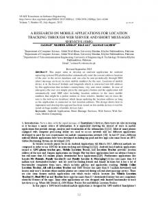
3.2 Results Average ratings for the different usability parameters of the selection techniques are presented in Figure 1. Satisfaction Reliability
Learnability Acceptability
Errors Efficiency
9
Average rating (1-9)
8 7 6 5 4 3 2 1 GPS
RFID
MAP
TEXT
Figure 1. The average ratings of the different usability parameters for each selection technique.
The evaluations were mainly very positive with certain exceptions. The RFID-based (RFID) and mapbased (MAP) selection techniques were rated highly on all usability evaluation scales. In contrast, automatic GPS-based selection (GPS) and textual selection (TEXT) had larger differences between the evaluations of the different usability parameters. Statistically significant differences between the selection techniques were found in the evaluations of satisfaction χF2=14.0, p