Lunar and Planetary Science XXXV (2004)
1106.pdf
A NEW CELESTIAL NAVIGATION METHOD FOR MARS LANDERS R. Trautner1, M. Bello Mora2, M. Hechler3, and D. Koschny1, 1Research and Scientific Support Department, ESA/ESTEC, NL, 2Deimos Engenharia, Lisbon, Portugal, 3ESA/ESOC, Darmstadt, Germany, Email:
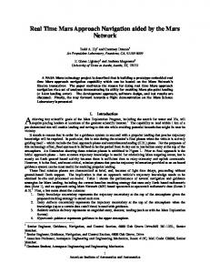
[email protected], Fax: ++31 (0) 71 565 3955 Introduction: The accurate determination of the position of a scientific planetary lander after its touchdown is an important issue for a number of scientific and technical reasons. Previous Mars missions have relied predominantly on position determination via a direct lander-earth radio link in combination with the correlation of topographic features on lander panorama images [1], [2], [3]. For the Viking 2 lander, the position was not undisputedly established due to the lack of horizon features [4]. Planetary landers without direct earth radio links such as the European Beagle2 lander [5] need to apply different navigation methods for the restriction of the search area within the entry, descent and landing error ellipses. In the following sections, the celestial navigation method developed and implemented for Beagle2 will be described. The achievable accuracy is presented, and a software implementation of the method is introduced. Position Determination with a Single Image: The celestial navigation method presented here relies on celestial objects populating orbits that are relatively close to the lander such as the Martian moons, Phobos and Deimos. When an image of such an object together with the star background is taken from the lander position, the separation angle between the photometric centers of stars and the object can be calculated. The separation angle α between the star and the COG of the target as seen from the landing site can be calculated by taking into account illumination models of the object. Using the separation angle and the image timestamp, a cone with inner angle α can be constructed, which originates at the COG of the navigation target, and intersects with the surface of Mars.
Fig. 1. Celestial Navigation on Mars using Phobos
The intersection represents all points on the surface of the lander target body, from where the moon can be seen under the observed separation angle at the time when the image was taken. Fig. 1 illustrates this principle, with Phobos as the navigation target. Additional stars on the navigation image allow the calculation of independent intersection lines. Using 3 or more stars, the lander position is uniquely identified. This method therefore allows determination of the position of a lander with a single image, provided that this image shows a suitable navigation object and 3 stars. In order to plan the acquisition of star and moon images, the corresponding imaging time and camera attitude need to be determined using dedicated image prediction software. Fig. 2 shows an example of an image prediction performed for the Beagle2 lander. Multiple Images / Advanced Data Processing: If multiple navigation images are available, the navigation results can be improved using well-established modern data processing and filtering methods. Navigation filters such as Kalman or Square Root Information Filter (SRIF) filters allow to include multiple information sources as well as the corresponding error data, and provide a powerful means for optimizing the position determination results. Error Sources and Overall Accuracy: The position determination method presented here is based on measurements obtained from processing images. The most important error sources are: camera hardware (image distortion, exposure time, timestamp accuracy), object / imaging geometry (angular separation of target stars, zenith angle), navigation object ephemeris data accuracy, astrometry (centerfinding error, number of target stars, navigation target illumination phases), digital elevation models, and atmospheric conditions (optical depth, geometry). For the current Mars missions (Beagle2, MER) the dominant error source is the existing ephemeris data for the Martian moons (σPhobos = 5 km along track, 3 km out of plane, and 3 km radially, from [6]). Using a single image as simulated in Figure 2, the position of the lander can be determined with an accuracy of ~ 4.1 x 6.4 km (1-σ), based on the landing area predictions obtained from ESA/ESOC and the performance figures of the Beagle2 SCS camera and lander clock. A number of 5-10 images can improve the result to ~ 2 x 3 km (1-σ). Scientific and Engineering By-Products: In addition to the utilization of nighttime images for navigation purposes, these images can also be used for the
Lunar and Planetary Science XXXV (2004)
accurate determination of the attitude of the lander camera. Since the camera attitude is related to the lander coordinate system, the lander base attitude can be calculated. Nighttime images of stars and navigation objects also allow the determination of important environmental characteristics such as optical depth of the atmosphere, and spectral investigations of the navigation objects. Other by-products include the postlanding verification of camera properties such as optical characteristics and toe-in angles for stereo cameras. If multiple navigation images are taken, they may serve to improve the ephemeris data for the navigation object, especially if the ephemeris uncertainty is the dominant source of error. ESA’s PLANAV Navigation Software Package: The European Space Agency has, in cooperation with industrial contractors, developed a celestial navigation software package for utilizing the presented navigation method for ongoing and future planetary lander missions. While the first application was planned for the Beagle2 lander of the Mars Express mission, the software architecture allows to utilize the package for any other planetary lander. All mission specific data such as planetary bodies, camera characteristics, landing site and atmospheric properties, digital elevation models, etc. can be modified easily in order to allow the application for future missions. The software provides modules for image opportunity prediction, covariance / Monte Carlo analysis (for both cone intersection for single images, and navigation filter for image series), visualization of navigation results, and attitude deter-
1106.pdf
mination. Fig. 2 shows examples for the imaging opportunity prediction and the landing site visualization. Conclusions: Previous Mars landers such as Viking and Mars Pathfinder have used Doppler tracking and horizon feature correlation for the detailed determination of the landing sites. For the Beagle2 mission, a celestial navigation method based on lander camera nighttime images has been developed for the determination of the lander’s position. Using current Phobos ephemeris data, the position of a Mars lander can be determined with an accuracy of ~ 5 km (1-σ) with a single night image. If the Phobos ephemeris errors can be reduced to 1 km, an accuracy of ~ 2 km (1-σ) can be achieved with one image. 5 images taken during few nights will then decrease the error to ~ 1 km (1-σ). The navigation method developed for Beagle2 allows a position determination with good accuracy at low cost, and without a mass penalty for the lander. Potential future application areas are missions to Mars and to other planetary bodies. References: [1] . Morris E. C., et al. (1978), ICARUS, Vol. 34,548-555. [2] . Morris E. C. and Jones K. L. (1980), ICARUS, Vol 44, 217-222. [3] Parker T. J. and Kirk R. L. (1999), Fifth Int. Conf. On Mars, Pasadena, Abstract No. 6124. [4] Zeitler W. and Kuschel M. (2000), Abstract No. 1612, LPSC XXIX, LPI, Houston. [5] Sims M., Pillinger C. T., et al. (1999) Adv.in Space Research, Vol. 23, 11, 19251928. [6] Banerdt W. B. and Neumann G. A. (1999), Abstract. No. 2021, LPSC XXX, LPI, Houston.
Fig. 2: Navigation image prediction and corresponding celestial navigation result in the Beagle2 landing area


![[PDF] Celestial Navigation - Google Sites](https://m.moam.info/img/260x300/pdf-celestial-navigation-google-sites_6477d33e097c4796708c2174.jpg)


![Celestial Navigation for Yachtsmen: 13th edition [PDF] - Google Sites](https://m.moam.info/img/260x300/celestial-navigation-for-yachtsmen-13th-edition-pd_647823d5097c474b228cdc68.jpg)


![FREE [PDF] Celestial Navigation: A Complete Home ... - Google Sites](https://m.moam.info/img/260x300/free-pdf-celestial-navigation-a-complete-home-goog_64782460097c474b228cdd06.jpg)
![[Read] Celestial Navigation: A Complete Home Study ... - Google Sites](https://m.moam.info/img/260x300/read-celestial-navigation-a-complete-home-study-go_64780466097c474e708c589e.jpg)