A Spatial Decision Support System prototype for assessing road HAZMAT accident impacts on the population in a dense urban area: a case study of the city of Nice, French Riviera Emmanuel Garbolino1, Roberto Sacile2, Samuel Olampi1, Chiara Bersani2, Angela Tomasoni3, Nicolas Alexandre4, Eva Trasforini2, Mauro Benza2, Davide Giglio2 1 Ecole des Mines de Paris, Pôle Cindyniques, rue Claude Daunesse, BP 207, 06904 Sophia Antipolis, France 2 Università di Genova, Dipartimento di Informatica Sistemica e Telematica, Via all'Opera Pia 13, 16145 Genova, Italy 3 Centro di ricerca Interuniversitario in Monitoraggio Ambientale, Via Cadorna 7, 17100 Savona, Italy 4 Università di Corsica, CNRS UMR 6134 – SPE, BP 52, 20250 Corte, France The authors present a Spatial Decision Support System (SDSS) for assessing the impact of a gas release from a hazmat (Hazardous Material) transportation accident on the population in a dense urbanized area (Nice, French Riviera). The data of hazmat type and routing come from two complementary prototypes: i) a hazmat identification system which recognizes the UN code of hazardous material carried by trucks ii) onboard sensors and GPS monitoring the flows of some hazmat trucks in real time. The Computer-Aided Management of Emergency Operations (CAMEO) is associated to the GIS platform in order to assess the dispersion distances of gas releases in the case of a hazmat accident on the highway that crosses the city of Nice on its northern sector. The SDSS provides maps of the population, infrastructures, environmental and economic stakes potentially affected by the gas release and it estimates the number of targets affected. This SDSS is dedicated to the emergency units and the highway companies in order to help the decision-makers in a context of crisis management. This SDSS is also a means to make the public authorities aware of the importance of the hazmat accident prevention and regulation.
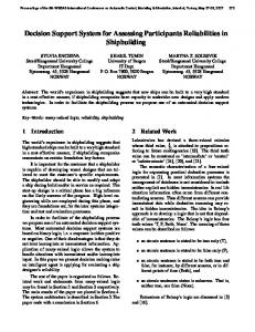
Context of the current project The road goods transportation between France and Italy involves a significant flow of trucks in the trans-border territories. For example, as shown in figure 1, the Ventimiglia highway station (Italy) reports a flow of 1.560.000 trucks for the year 2005 (i.e. more than 4.900 per day excluding Sundays when trucks are forbidden). Among these goods, it is estimated that 10% (156.000 in a year and 500 per day) corresponds to HAZMATs (hazardous materials). These estimations come from counting campaigns of few days duration executed by the ESCOTA (the highway company) and the public 1
Corresponding author. Tel.: + 33 4 93 95 74 75 ; fax: + 33 4 93 65 43 04 E-mail address:
[email protected]
Formattati: Elenchi puntati e numerati
administrations. However, it is important to note that the HAZMAT type, quantity, itinerary, and delivery time are not known by the public authorities, the highway companies, and by the population living in the territories crossed by these vehicles. In this respect, HAZMATs transportation on road actually represents a potentially high risk with regard to: • The nature of the HAZMATs carried by trucks and the physicochemical events associated with these materials (radioactivity, explosion, toxicity, corrosion etc.); • The nature, the localization and the density of the stakes (population, economic activities, buildings, networks, infrastructures, natural areas etc.); • The characteristics and state of the roads (topography, layout, presence of tunnels etc.); • The density of the traffic, and the environmental conditions (weather, natural events etc.). Daly average of trucks and Hazmat Transportation crossing the highway station of Ventimiglia (Italy) 5000
Truks
4500
Hazmat (estimation)
Number of truks
4000 3500 3000 2500 2000 1500 1000 500
05 20
03
04 20
02 20
20
00
99
01 20
20
19
98
97 19
19
96
95 19
19
93
94 19
19
91
92 19
90 19
19
80 19
19
85
0 Years
Figure 1: Daily average of trucks and Hazardous Material Transportations crossing the highway station of Ventimiglia (Italy): this graph shows a continuous increase of the Hazmat transportation by road. This framework became the starting point of a collaboration between the Pôle Cindyniques of the Ecole des Mines de Paris / ARMINES (France) and the Centro Italiano di Eccellenza in Logistica Integrata of the University of Genova (Italy), in the EU framework INTERREG III A Alcotra Project called “Definition, design and implementation of a prototype of a distributed Information System for the identification, the monitoring and the management of HAZMATs transportation by road in order to secure the transport infrastructures on the road axis Nice-Imperia-Savona”. Due to the complexity of the HAZMATs transportation problem for the decision-makers in terms of risk assessment, risk prevention and crisis management and intervention, it appears useful to design and develop a Spatial Decision Support System (SDSS) that would answer to this question: What is the risk for the stakes in case of a HAZMAT road transportation accident with respect to the nature of the hazardous material? This article presents the modules of the SDSS which have been developed, their
Eliminato:
relationships and a case study on the exposition of the population in the case of a toxic gas release induced by a HAZMAT transportation accident on the highway that crosses the city of Nice.
The Spatial Decision Support Systems (SDSS) for HAZMAT road transportation crisis prevention and management: principles, data and modules A SDSS is an interactive, computer-based system designed to support a user or group of users in achieving a higher effectiveness in decision-making while solving a semistructured spatial decision problem (Densham, 1991). The decision-making process is composed of three phases (Simon 1960): the intelligence phase involves searching and scanning the environment for conditions calling for decisions. The design phase is the proposition of the different alternatives to solve the problem identified in the intelligence phase. The last phase is the choice which is actually made between the different solutions which have been proposed. The use of the SDSS for the management of HAZMATs transportation is well recognized (Frank et al., 2000; Zhang et al., 2000; Zografos et al., 2000). The system described in this paper proposes a SDSS that is based on GIS (Geographic Information Systems) technology in order to provide decisionmakers with the information on the probable impacts of an HAZMAT transportation accident. This SDSS is based on the four following modules (figure 2): • A database that centralizes, in real time, the data on HAZMAT transportation coming from both embarked sensors monitoring the physical conditions of the hazmat product in the tank of the truck, the truck route, its speed etc. (Atzei et al., 2004) and an installed optical sensor placed in the highway station of Saint-Isidore, near Nice (French Riviera), which detects orange plates of the HAZMAT trucks crossing this highway station (Casazza et al., 2006 a and b); • A module which extracts the data i.e. the nature of hazardous material carried, the route of the vehicle, the date etc. Another module (not presented here) has been developed in order to calculate the accident risk probability based on the topography, the traffic concentration, the weather etc. (Bensa et al., 2006). • The software CAMEO (Computer-Aided Management of Emergency Operations) which has been developed by the NOAA (National Oceanic and Atmospheric Administration) and which calculate the propagation distances in the atmosphere of more than 6.000 chemicals. This software is used by the Civil Protection in the USA for the management of crisis intervention (Martin et al., 2004). • A GIS (Geographical Information System) plate-form integrating the databases on the stakes of the territory (population, housing, companies, etc.) with the maps of the atmospheric dispersion distances of toxics coming from the simulations computed with CAMEO. The overlapping of the maps of these gas release distances and the data on the stakes allow the user to identify the exposed (or impacted) stakes. These results provide the authorities, the Civil Protection and the highway company with useful information to prepare the Specific Intervention Plan (SIP) in case of an HAZMAT transportation accident on the highway. This information can also help these decision-makers to face a crisis generated by a HAZMAT transportation accident on
this territory, in a real time. The next paragraph deals with an example of a HAZMAT transportation accident involving a toxic gas release in order to present the results of the impact assessment on the population and on other stakes. Data extraction and treatment • Nature of Hazmat • Hazard type • Date and time ….
Toxicological thresholds data
CAMEO (Gas release simulation)
2
HAZMAT transportation Databases
• Model of propagation • Toxicological thresholds • Distances of propagation
GIS
Meteorological data
3
Population data
Registry data
• Maps of pollutant dispersion
Housing data
Historical data
• Identification of impacted stakes
Companies data
Real-time data
• Statistics production
1
4
Location of the establishments receiving the public
Sensors data
• Intervention Planning Optical Recognition Prototype
GPS and distributed sensors
• Crisis Management
Figure 2: The Spatial Decision Support System developed in the frame of the TMDNIS Interreg III project and the Impact Accident Assessment Module.
Example of a scenario of a HAZMAT transportation road accident on the population and goods in the city of Nice, French Riviera The selected area for the accident simulation is a portion of the highway A8 that crosses the city of Nice in its north side. The accident statistics provided by the Public Authorities show that this spot is frequently involved in accidents due to the conformation of the road which is characterized by a curved tunnel and a turn at the exit of the tunnel. This spot is surrounded by numerous buildings, houses, commercial centers, a stadium etc. Since 2005, different chemical transportations have been identified by the Optical Recognition Prototype like Hydrochloric Acid, Toluene Di-Isocyanate, Ammoniac, Styrene, LPG, Acetic Acid, etc. The hazardous material considered in this accident simulation is the Ethylene Oxide (C2H4O) which transportation between France and Italy is regulated by the Public Authorities in the territory of Nice (transportation authorized between 10 PM and 6 AM with 30 minutes between each vehicle). This substance has been identified by the Optical Recognition Prototype at 11 PM at Saint Isidore highway station which is located 7.5 km from the accident simulation spot. The Ethylene Oxide is an important industrial chemical used as an intermediate in the production of ethylene glycol and other chemicals, and as a sterilant for foodstuffs and medical supplies. This chemical is explosive and toxic. Ethylene oxide is usually stored as a pressurized or refrigerated liquid. At room temperature and pressure, it rapidly evaporates, potentially causing frostbite in cases of skin exposure. Ethylene oxide is toxic by inhalation. Symptoms of overexposure include headache and dizziness,
progressing with increasing exposure to convulsions, seizure and coma. It is also an irritant to the skin and the respiratory tract, and inhaling the vapors may cause the lungs to fill with fluid (irritation oedema) several hours after the exposure. The scenario takes into account three reference concentrations in order to model the propagation distances of a gas release of Ethylene Oxide, coming from an orifice of 10 cm of diameter situated in the inferior part of the truck tank. At 30.000 ppm and with the presence of an ignition source, the Ethylene Oxide induces an UVCE (Unconfined Vapour Cloud Explosion). At 2.900 ppm (Lethal Concentration for 5% of the population exposed), this chemical causes major symptoms like convulsions, coma and pulmonary oedema. At 800 ppm (Inferior Limit of Irreversible Effects) this substance does not induce irreversible effects on health; it mainly induces symptoms such as headache and dizziness. The weather parameters used for the simulations are the temperature (20°C) and the speed of wind (1 m.s-1). CAMEO also takes into account the ground roughness for which the “Forest – Urban” category has been selected. It is important to remind that the propagation distances of the Ethylene Oxide are not the widest one but our scope was to study a hazardous material which strongly interests the Public Authorities and which has known a regulation process since 2000. The results concerning the propagation distances of gas releases for the other hazardous materials shall also interest the Public Authorities in a perspective for the prevention of HAZMAT transportation accidents. The propagation distances simulated are presented in the following figure (figure 3) for each concentration of Ethylene Oxide. At 30.000 ppm of concentration the maximum propagation distance is 96 m; at a concentration of 2.900 ppm, the maximum propagation distance is 290 m and at 800 ppm, the maximum propagation distance is 587 m.
French Riviera
1
2
3
Concentration of Ethylene Oxide gas release UVCE (30.000 ppm) Lethal Concentration (2.900 ppm) Inferior Limit of Irreversible Effects (800 ppm)
Figure 3: Example of three dispersion distances of a toxic gas (Ethylene Oxide) coming from a truck accident on the A8 highway. These distances have been calculated with regard to the Ethylene thresholds as defined above. The integration of these propagation distances into a GIS (ArcMap) and the overlapping
with the stakes layers give the estimation of the exposed population, housings etc. in this area (table 1). Concentration (ppm)
Distances (m)
Exposed Population
Deaths
Exposed Buildings
Exposed Housings
Exposed ERP*
30.000
96
174
174
12
94
0
2.900
290
1260
63
141
656
12
800
587
6215
0
679
3212
48
Table 1: Exposed stakes estimated by using the ancillary databases of the stakes of the city of Nice in relation to the propagation distances of a Ethylene Oxide gas release according to the different concentrations (* ERP: Establishments Receiving the Public).
Conclusion and perspectives The SDSS for HAZMAT road transportation for crisis prevention and management provides the decision-makers with information based on the nature of the chemicals transported on the A8 highway, their routing etc. and their probable impact on the population and stakes in the studied territory. These information can help the decision makers to define their SIP and to manage a crisis situation. One of the improvements of the SDSS will be the integration of the population and vehicles flow models during the day in order to manage these targets in case of a real HAZMAT transportation accident in this area.
References Atzei F., Giglio D., Minciardi R., Paolucci M., Pizzorni D., Sacile R., Trasforini E. e Vicini G., 2004, Instradamento dinamico basato sul rischio nel trasporto di merci pericolose su strada, VGR 2004, Pisa. Bensa M., Bersani C., Casazza R., Garbolino E., Giglio D., Olampi S., Sacile R. e Trasforini E., 2006, Definizione, progettazione e realizzazione prototipale di un sistema informativo distribuito per l’identificazione, il monitoraggio e la gestione dei flussi veicolari di merci pericolose, VGR2006, Pisa, 17-19 Octobre. Casazza R., Garbolino E., Olampi S., Bersani C., Trasforini E., Giglio D. and Sacile R., 2006a, Detection and monitoring of hazardous material transportation on road between france and italy : objectives, methodology and first results, Safety and Reliability for Managing Risk, C. Guedes Soares and E. Zio Editors, volume 3: 2659–2666. Casazza R., Olampi S. and Napoli A., 2006b, A sensor based decision support system for the hazmat transport risk, UDMS2006. Densham P.J., 1991, Spatial decision support systems, Geographical information systems: principles and applications, Longman. Frank W:C:, Thill J-C. and Batta R., 2000, Spatial decision support system for hazardous material truck routing. Transportation research Part C, vol. 8: 337-359. Martin P.H., LeBoeuf E.J., Danie E.B., Dobbins J.P. and Abkowitz M.D., 2004, Development of a GIS-based Spill Management Information System, Journal of Hazardous Materials, vol. 112: 239–252. Simon H.A., 1960, The new science of management decision, New York: Harper and Row, plublishers, New York and Evanston. Zhang J., Hodgson J. and Erkut E., 2000, Using GIS to assess the risks of hazardous materials transport in networks, EJOR, Vol. 121: 316-329. Zografos K.G., Vasilakis G.M. and Giannouli I.M., 2000, Methodological framework for developing decision support systems (DSS) for hazardous materials emergency response operations, Journal of Hazardous Materials, Vol. 71, Issues 1-3: 503-521.