EPSC Abstracts Vol. 6, EPSC-DPS2011-813, 2011 EPSC-DPS Joint Meeting 2011 c Author(s) 2011
Permanently Shadowed Regions near Lunar Poles Derived From Chang’ E-1 Digital Elevation Model X. Ren(1), J.J. Liu(1), F.F. Wang(1), X.Y. Gao(1), Z.B. Zhang(1), L. Zheng(1), and C.L. Li(1) (1)National Astronomical Observatories, Chinese Academy of Sciences, Beijing, 100012, China (
[email protected], +86-010-64888703)
Abstract
illumination conditions within 5° of the lunar poles for the year 2020.
We have accurately simulated realistic illumination conditions at the lunar poles by using a digital elevation model(DEM) derived from CCD stereo camera images and Laser Altimeter ranges onboard the Chinese lunar orbiter Chang’ E-1 (or CE-1). We generated an illumination map within 10° of the lunar poles for the future 10 years. From this, we conclude that there are permanently shadowed regions near the lunar poles, and the areas of these regions are respectively 6350km2 and 1781km2 in south and north. But we find no permanently sunlit regions.
In this work, we used the Chang’E-1 DEM to analyze the illumination conditions within 10° of the lunar poles. This DEM with the spatial resolution of 500m has been produced by using CCD stereo camera images and laser altimeter ranges onboard the Chinese lunar orbiter Chang’ E-1(C.L. Li et al., Photogrammetric Processing and Lunar Global Topographic Map from the Chang’E-1 Three Linearray CCD Data, in preparation, 2011).
2. Method and Results 1. Introduction The spin axis of the moon is inclined by only 1.5 degrees from the normal to the plane of moon’s path around the sun (ecliptic plane). This geometry made sunlight direction approximately parallel to the horizon near the poles. That causes locations near the poles to experience extreme illumination conditions. Topographically higher regions receive near constant solar illumination. While topographic lows may be permanently shaded from sun and should achieve very low temperatures. (Bussey et al., 2003) using empirical formula, estimated the areas of permanent shadow in lunar south and north, which were respectively 6500km2 and 7500km2. (Bussey et al., 1999, 2005) using images captured by Clementine UVVIS camera, produced quantitative illumination maps within 45km of the lunar poles. (Margot et al.,1999) using DEM data produced by Earth-based radar measurements, estimated that the areas of permanent shadow within 1.5° of the lunar south pole and north pole were respectively 2550km2 and 1030km2. (Noda et al.,2008) using DEM data produced by Kaguya(SELENE) laser altimeter, analyzed the illumination conditions within 4° of the lunar poles for 2000 earth day (about 5.5 years). (Bussey et al., 2010) using the same DEM data, analyzed the
The technique we employed is identical to (Margot et al., 1999), (Noda et al., 2008) and (Bussey et al., 2010). We used ray-tracing technique to calculate whether the Sun is visible from each location within 10° of the lunar poles. Firstly, we used JPL DE421 ephemeris data to calculate the solar direction vector from the Sun to a lunar surface point at a given time. Secondly, starting from the point, the vector is divided into a number of equidistant nodes, the distance between the neighboring nodes is identical to DEM spatial resolution. Finally, if there is a node under DEM surface, the vector is blocked by terrain and therefore the Sun is invisible from the point at the time, otherwise the Sun is visible. The caculation will be done for every DEM grid point above latitude of 80°. If the point is blocked a value of zero is assigned to the surface sunlight lever, if unblocked a value of one is assigned. Then a sunlight map at a given time has been obtained. The size and spatial resolution of the map are as same as those of the used DEM. A series of sunlight map should be caculated cover the lunar precession period(about 18 years). Considering the amount of calculation, the total time length of our calculating is only 3650 days (about 10 years). The time difference between adjacent sunlight maps is 4-hour. Altogether we generated 43,832 sunlight maps (21,913 for south pole, 21,919 for north pole). We accumulated these maps and
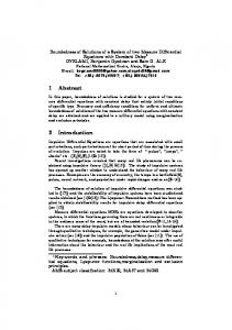
calculated the percentage of illumination time for every grid point, and the illumination maps for the lunar polar regions have been produced(see Fig.1). Considering that lunar surface curvature may influence the results of calculating, we used the lunar body-fixed coordinate system. In our processing, we have also considered the eclipse’s influence to the simulation results. We also calculated the illumination time of 19 years for several wellilluminated points, the difference between results of 10 years and 19 years is less than 0.5%.
Acknowledgements We wish to thank all members from the Ground Research & Application System (GRAS) of the Chang’E-1 program, whose joint efforts have made the data acquisition and preprocessing used for this study possible. Chang’E-1 is operated by the China National Space Administration (CNSA), and belongs to China’s Lunar Exploration Program (CLEP).
References [1] Author, A., Author, B., and Author, C.: First example of a cited article title, First Example Journal, Vol. 1, pp. 1100, 1999. [1] Bussey D B J, McGovern J A, Spudis P D, et al.: Illumination conditions of the south pole of the Moon derived using Kaguya topography, Icarus, 208, pp.558564,2010. [2] Bussey D B J, Fristad K E,Schenk P M.:Constant illumination at the lunar north pole, Nature 434, 842, doi:10.1038/434842a, 2005.
Fig.1 The illumination map within 10° of the lunar poles for 10 years. The left picture is north pole, and the right is south pole. In Fig.1, we can see that there are permanently shadowed regions, whose illumination time is 0%, the black part in above picture. They are mainly distributed near the lunar poles. Their areas are respectively 6350km2 and 17831km2 for south and north, and obviously there are more shaded regions in the south than in the north. It is mainly because there are several deep craters (de Gerlache, Faustini, Haworth, Shackleton, Shoemaker, Sverdrup) near the south pole. While there are no large craters in the north, which results in less long-durable shadow regions. But there are no permanently sunlight regions, whose illumination time is 100%. In order to compare with previous results, we also calculated the areas of permanently shadowed regions within 4° and 2.5° of the lunar poles (see Table1).
[3] Bussey D B J, Lucey P G, Steutel D, et al.:Permanent shadow in simple craters near the lunar poles, Geophys. Res. Lett., 30(6),1278, doi:10.1029/2002GL016180,2003. [4] Bussey D B J, Spudis P D, Robinson M S.:Illumination conditions at the lunar South Pole, Geophys. Res. Lett., 26(9), 1187-1190,1999. [5] Margot J L, Campbell D B, Jurgens R F, et al.: Topography of the Lunar Poles from Radar Interferometry: A Survey of Cold Trap Locations, Science, 284 (5420),1658-1660,1999. [6] Noda H, Araki H, Goossens S, et al.: Illumination conditions at the lunar polar regions by KAGUYA(SELENE) laser altimeter, Geophys. Res. Lett., 35,L24203, 2008.
Table.1 Comparison of permanently shadowed regions areas between our work and previous resultsa Polar Regions North(87.5°) South(87.5°) North(86.0°) South(86.0°) a
our work (km2) 895 4532 1418 8019
Bussey et al.,2010(km2) - - - 5058
Noda et al.,2008(km2) 844 2751 - -
Margot et al.,1999(km2) 1030 2550 - -
Nozette et al.,1996(km2) 530 6361 - -
North (87.5°) and South (87.5°) stand for within 2.5°of the lunar north and south poles respectively. North (86.0°) and South (86.0°) stand for within 4°of the lunar north and south poles respectively. The sign “-” stands for there is no previous result.