Othello WV2. Othello S2. WV2 Reg. S2 Reg. Optical and Thermal Requirements for Agricultural and Environmental Monitoring. Guy Serbin1, E. Raymond Hunt ...
Optical and Thermal Requirements for Agricultural and Environmental Monitoring Guy Serbin1, E. Raymond Hunt Jr.2, Craig S.T. Daughtry2, Martha C. Anderson2, Andrew M. French3, and David J. Brown4 InuTeq LLC, Washington, DC; 2 USDA/ARS Hydrology and Remote Sensing Lab, Beltsville, MD; 3 USDA/ARS Water Management and Conservation Research Unit, Maricopa, AZ; 4 Dept. of Crop and Soil Sciences, Washington State University, Pullman, WA
Remote sensing live vegetation cover and health
• Remote sensing methods allow for rapid assessment of the environment and agriculture over wide areas. • Remote sensing methods are most effective when optimized: • Spectrally • Spatially • Temporally • Radiometrically • Thus, we aim to define the requirements.
• Most plant cover/ condition remote sensing use Normalized Difference Vegetation Index (NDVI):
NIR Re d NDVI NIR Re d
Land use/ land cover change Vegetation health/ global crop forecasting In-field crop stress mapping/ precision farming Dry (flammable) biomass cover Verification of: Crop insurance claims Conservation practices: Cover crops Tillage
Plant cover/ leaf area index Vegetation stresses: Plant nitrogen (chlorophyll content) Plant water Dry cellulose (crop residues/ plant litter/ non-photosynthetic vegetation) • Evapotranspiration • Atmospheric vapor for correction to surface reflectance.
Spectral bands: visible through SWIR
0.4 0.3
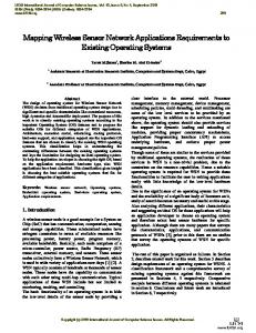
Barnes WV2 Barnes S2 Codorus WV2 Codorus S2 Othello WV2 Othello S2 WV2 Reg. S2 Reg.
0.0 4.0 3.5
• Red Edge indices require at least one band at 720 nm (Worldview-2, RapidEye), plus red, NIR bands. • The MERIS Terrestrial Chlorophyll Index (MTCI) least affected by soil.
0.2 0.1
• The position of the Red Edge can indicate nitrogen stress conditions.
• Red Edge is better imaged with bands at 705 and 740 nm: • Sentinel-2 mean soil MTCI = 0.82, std. dev. = 0.29, N = 4257
3.0
• Red edge indices are sensitive to chlorophyll (bands shown are for Sentinel-2):
2.0
• Worldview-2 (one band at 720 nm) mean soil MTCI = 0.91, std. dev. = 3.29
1.0 0.5 0.0 10
R740 R705 MTCI R705 R665
Figure 3. Chlorophyll content and the Red Edge.
2.5
1.5
R740 R705 Re d EdgeNDVI R740 R705
20
30
40
50
60
70
80
Leaf chlorophyll (mg/cm2)
Figure 4. Red Edge Index simulations for Worldview-1 and Sentinel-2 for corn at LAI = 1.
Remote Sensing of Canopy Water and Evapotranspiration • Soil moisture deficiencies cause leaf stomata to close up: • Evapotranspiration and photosynthesis decrease; • Vegetation heats up;
So what do we specifically want to measure? • • • • •
0.5
• NDVI not overly sensitive to chlorophyll.
What are the applications? • • • • • • • • •
Red edge index simulations for corn at LAI = 1
Red Edge NDVI
Introduction
MTCI
1
• Yields can be negatively impacted. • NIR and SWIR band at 1610 – 1650 nm can be used to estimate canopy water content: • SWIR band reflectance inversely related to leaf water content. • LDCM’s split thermal infrared (TIR) bands (10.8 and 12.0 mm) will allow for estimation of canopy evapotranspiration (ET). • Additional thermal bands at 8.6 and 9.1 mm will help improve emissivity estimation. Figure 5. Remote sensing of evapotranspiration at different scales.
Remote sensing dry biomass • Dry biomass (senescent vegetation) serves a number of purposes: • As crop residues left on a surface for conservation tillage practices • As a feedstock for cellulosic biofuels • As an indicator of rangeland health and grazing • As fuel for wildfires.
Reflectance
0.4
2211
0.4
2101
2031
0.5
0.3 0.3
Cla CrA Hm Res LC
0.2
0.1 0.1
Figure 1. Spectra of soil, crop residue and green vegetation, proposed bandwidths for the Landsat Data Continuity Mission (LDCM)’s Operational Land Imager (OLI, Sentinel-2, and an ideal agricultural satellite mission (AgSat), and the spectral response functions for the Advanced Spaceborne Thermal Emission and Reflection Radiometer (ASTER) sensor.
Landsat TM
ASTER
0.0
0.0 12 3
4
56789
5 6
Disclaimer: This concept is based on discussions about satellite data requirements for agricultural monitoring and does not represent official USDA or ARS policy.
8
9
F
12 3 4
400
1000
5
1600
7
2200
Wavelength (nm)
7
2000
2200
2400
Figure 6A. Intensively tilled field
B. Conservation tilled (no-tilled) field
CAI 100R2030 R2210 / 2 R2100
• CAI targets an absorption occurring at 2100 nm present for all sugars, including cellulose. • Most soil minerals do not have absorptions in this region. • CAI has a linear relationship between bare soil, 100% dry biomass cover.
C. Prescribed rangeland burn, image courtesy Wyoming Wildlife and Natural Resource Trust
D. Simi Valley, CA, Oct. 14, 2008. (Associated Press)
Wavelength (nm)
Spectral bands: TIR
Figure 2. TIR emissivity response and spectra. Blue: MODIS bands 29, 31, 32. Green: ASTER bands 10 – 14. Red: Sandy soil emissivity, SGP97 experiment, El Reno, OK.
7
• Below 2000 nm, dry biomass and soils can be spectrally similar. • Broad Landsat TM bands cannot discriminate narrow spectral features of dry vegetation components. • Cellulose Absorption Index (CAI) ideal for sensing dry vegetation:
What would an ideal agricultural satellite look like? Band number 1 2
Band center and bandpass (nm) 443 (433–453) 480 (470–490)
3
Region
Parameter
Blue Blue
Coastal/Aerosols Aerosols
550 (540–560)
Green
Chlorophyll
4 5 6
670 (660–680) 705 (695.5–712.5) 740 (732.5–747.5)
Red Red edge Red edge
Vegetation cover Chlorophyll Chlorophyll
7
850 (840–860)
NIR
Vegetation cover
8 9
940 (950–960) 1375 (1360–1390)
NIR SWIR
10
1650 (1625–1675)
SWIR
11 12 13 14 15 16 17
2040 (2025–2055) 2100 (2080–2120) 2210 (2190–2230) 8.6 (8.475–8.825) mm 9.1 (8.925 - 9.275) mm 10.8 (10.3–11.3) mm 12.0 (11.5–12.5) mm
SWIR SWIR SWIR TIR TIR TIR TIR
Water vapor Cirrus clouds Vegetation water content Cellulose Cellulose Cellulose Emissivity Emissivity ET, Vegetation stress ET, Vegetation stress
Indices EVI GNDVI, Red Edge indices EVI, NDVI Red Edge indices Red Edge indices EVI, NDVI, NDWI
Heritage LDCM Landsat TM Landsat TM Landsat TM Sentinel-2 Sentinel-2 Landsat TM Sentinel-2 LDCM
NDWI
Landsat TM
CAI CAI CAI
New band New band New band ASTER ASTER LDCM LDCM
DisALEXI DisALEXI
• Temporal resolution requirements: < 7 days, 5 day or better ideal. • Pixel size: 60 m maximal in visible through SWIR (VSWIR), 100 m TIR; • 20 m ideal VSWIR, 60 m TIR. • Nadir looking. • Swath width constrained to a maximum 20° off-nadir view angle: • Minimizes BRDF problems; • Minimizes obscurement of soil by canopy, residue; • Ensures radiometric accuracy in TIR. • Quantization = 12 bits. • Signal-to-Noise Ratio (SNR) requirements: >250. • Narrower ASTER-type bands in SWIR to discriminate cellulose absorption.
References: • Anderson, M.C., et al. 2011. Mapping daily evapotranspiration at field to continental scales using geostationary and polar orbiting satellite imagery. Hydrol. Earth Syst. Sci. 15:223–239. • Brown, D.J., K.D. Shepherd, M.G. Walsh, M.D. Mays, and T.G. Reinsch. 2006. Global soil characterization with VNIR diffuse reflectance spectroscopy. Geoderma 132:273-290. • Dash, J. and P.J. Curran. 2007. Evaluation of the MERIS terrestrial chlorophyll index (MTCI). Advances in Space Research 39:100-104. • Gitelson, A.A. and M.N. Merzlyak. 1996. Signature analysis of leaf reflectance spectra: algorithm development for remote sensing of chlorophyll. J. Plant Physiol. 148:495-500. • Serbin, G., E.R. Hunt, Jr., C.S.T. Daughtry, G.W. McCarty, and P.C. Doraiswamy. 2009a. An Improved ASTER Index for Remote Sensing of Crop Residue. Remote Sensing 1:971-991. • Serbin, G., C.S.T. Daughtry, E.R. Hunt, Jr., D.J. Brown, and G.W. McCarty. 2009b. Effect of soil spectral properties on remote sensing of crop residue cover. Soil Science Society of America Journal 73:1545-1558. • Serbin, G., E.R. Hunt, Jr., C.S.T. Daughtry, D.J. Brown, G.W. McCarty, and P.C. Doraiswamy. 2010. Assessment of Spectral Indices for Crop Residue Cover Estimation Proc. Proceedings of the 2010 IEEE International Geoscience and Remote Sensing Symposium, Honolulu, HI. July 25, 2010. IEEE.