EPJ Web of Conferences 176, 02010 (2018) https://doi.org/10.1051/epjconf/201817602010 ILRC 28
AEOLUS END-TO-END SIMULATOR AND WIND RETRIEVAL ALGORITHMS UP TO LEVEL 1B
Oliver Reitebuch1*, Uwe Marksteiner1, Marc Rompel1, Markus Meringer2, Karsten Schmidt2, Dorit Huber3, Ines Nikolaus4, Alain Dabas5, Jonathan Marshall6, Frank de Bruin7, Thomas Kanitz7, Anne-Grete Straume7 1
DLR, Institute of Atmospheric Physics, *
[email protected] 2 DLR, Remote Sensing Technology Institute, Germany 3 DoRIT, Germany 4 University of Applied Sciences Munich, Germany 5 CNRS/Météo-France, CNRM, France 6 Airbus Defence and Space, UK 7 ESA-ESTEC, The Netherlands
ABSTRACT The first wind lidar in space ALADIN will be deployed on ESA´s Aeolus mission. In order to assess the performance of ALADIN and to optimize the wind retrieval and calibration algorithms an end-to-end simulator was developed. This allows realistic simulations of data downlinked by Aeolus. Together with operational processors this setup is used to assess random and systematic error sources and perform sensitivity studies about the influence of atmospheric and instrument parameters. 1
INTRODUCTION
The European Space Agency (ESA) is currently implementing a Doppler wind lidar mission named Atmospheric Dynamics Mission ADMAeolus [1]. It is considered as a technology demonstrator for future operational wind lidar missions. The launch of the satellite is currently planned for 2018. Aeolus will provide profiles of one component of the horizontal wind vector along the laser line-of-sight (LOS) from ground up to the lower stratosphere (20 km to 30 km) with 250 m to 2 km vertical resolution and a precision of 1 m/s to 3 m/s depending on altitude [2]. A wind profile will be obtained from horizontal averaging over 90 km along track in order to achieve the precision requirement (random error). Systematic errors, which cannot be corrected by a-priori knowledge (e.g., calibration, instrumental corrections) – called an “unknown bias” – are very detrimental for numerical weather prediction (NWP) models.
Thus, the requirement for the maximum “unknown bias” of 0.7 m/s is very stringent and is further separated into a wind-independent contribution of 0.5 m/s and a wind-dependent contribution of 0.7 %. The lidar ALADIN (Atmospheric LAser Doppler INstrument) is based on a direct-detection Doppler wind lidar (DWL) operating at an ultraviolet (UV) wavelength of 354.8 nm [3]. The optical receiver consists of two spectrometers to determine the Doppler shift from the spectrally broad Rayleigh-Brillouin molecular backscatter and the spectrally narrow Mie backscatter from aerosols and cloud particles [4]. Accumulation charge coupled device (ACCD) detectors are used for both the Mie and Rayleigh spectrometer. The minimum vertical resolution of the ALADIN instrument is limited by the ACCD detector to 250 m and only a limited number of 24 atmospheric altitude ranges can be acquired. On the other hand the vertical resolution can be varied from 250 m to 2000 m even within one vertical profile. The number of laser pulse returns accumulated directly on the detector is a settable parameter and determines the minimum alongtrack horizontal resolution for the raw data, which is typically 3 km for a number of 20 accumulated laser pulses (called “measurement”). Both the Mie and the Rayleigh spectrometer data are stored with this temporal resolution on-board and transmitted to the ground via an X-band downlink every orbit. Further averaging of 600 laser pulse returns (12 s data, 90 km along-track resolution, called “observation”) is performed on-ground and
© The Authors, published by EDP Sciences. This is an open access article distributed under the terms of the Creative Commons Attribution License 4.0 (http://creativecommons.org/licenses/by/4.0/).
EPJ Web of Conferences 176, 02010 (2018) https://doi.org/10.1051/epjconf/201817602010 ILRC 28
is needed to achieve the random error requirement of 1 m/s to 3 m/s. 2
AEOLUS PROCESSING CHAIN
The downlinked data (called Annotated Instrument Source Packets AISP) from ALADIN spectrometers, instrument and platform status (e.g. settings, temperatures) and AOCS (Attitude and Orbit Control System) are processed on-ground to obtain several levels of data products (Level 0, 1A, 1B, 2A, 2B, 2C). For Level 1 data products (processed instrument data) only information from the Aeolus satellite with the ALADIN instrument and the AOCS is used. For Level 2 products additional information from other sources is used, mainly the atmospheric temperature and pressure profiles for correcting the winds derived with the Rayleigh spectrometer from the temperature and pressure dependent signal bandwidth of the Rayleigh-Brillouin scattering [5]. Algorithms for Level 2 data products (derived geophysical wind and aerosol variables) use also a horizontal and vertical grouping of measurements to discriminate clear and cloudy atmospheric scenes [6]. An end-to-end simulator (E2S) was developed for the Aeolus mission with the following objectives:
testing the ground segment processor chain from Level 0 to Level 2 assessing the performance of ALADIN with respect to random and systematic errors performing sensitivity studies to optimize instrument settings, calibration methods and retrieval algorithms validating the Aeolus mission after launch.
Thus, the Aeolus E2S is continuously updated with new functionalities and instrument parameters arising from characterization of the ALADIN instrument on-ground and from experience with the ALADIN airborne demonstrator (A2D). The A2D was developed in order to assess the performance of ALADIN and to optimize the retrieval algorithms with “real” atmospheric signals [7]. Several airborne campaigns with a coherent-detection wind lidar as a reference and the A2D were performed for prelaunch validation of Aeolus from 2007-2009 [8], together with the NASA DC-8 aircraft in 2015 [9]
2
and recently during NAWDEX (North Atlantic Waveguide and Downstream Impact Experiment) in 2016. More than 100 recommendations for testing and operating the ALADIN instrument onground and in-orbit and for refinement of the retrieval algorithms and calibration strategy were derived from the experience with the A2D [10] and adapted to the modelling of the ALADIN instrument in the E2S and for the wind retrieval algorithms in the L1B processor. 3
AEOLUS END-TO-END SIMULATOR
The E2S is not only a simulator for the lidar instrument ALADIN interacting with the atmosphere, but also includes modules for the satellite orbit, the AOCS and allows to couple a Digital Elevation Model (DEM) and spatially resolved global information about the surface albedo [11]. DEM and albedo information is important for a correct simulation of the range and intensity of the surface return, which is used for ALADIN calibration and bias correction schemes. In order to be able to use the E2S for testing the complete chain of processors, the output data are provided in the same format and temporal and spatial resolution as it will be downlinked from the satellite as AISP. In order to use the E2S for performance assessment, sensitivity studies and optimization of retrieval algorithms it allows for the:
use of atmospheric vertical profiles (e.g. backscatter and extinction of aerosol and clouds from climatology or earlier lidar missions as LITE or CALIPSO, wind profiles from radiosondes or ECMWF model) with high vertical and temporal resolution, e.g. to simulate atmospheric inhomogeneities equivalent to the measurement data resolution of Aeolus of 3 km; for some sensitivity studies the atmospheric profiles were even varied per laser shot with a pulse repetition rate of 50 Hz simulation of spectrally resolved atmospheric backscatter signal of Mie scattering from aerosol and cloud particles and Rayleigh-Brillouin scattering from molecules [12]
EPJ Web of Conferences 176, 02010 (2018) https://doi.org/10.1051/epjconf/201817602010 ILRC 28
Basis Document (ATBD) [14] and an overview is provided in [6]. The main product from Aeolus will be LOS winds projected to the horizontal plane – called HLOS winds. The L1B algorithms will use only information provided from Aeolus itself (AOCS data, ALADIN wind mode data, ALADIN response calibration mode data) to derive L1B HLOS wind profiles averaged over 1 observation derived from both the Mie and Rayleigh spectrometer data. Thus, the L1B Rayleigh HLOS winds will exhibit a significant bias due to non-correction of the actual atmospheric temperature profile and of the crosstalk of spectrally narrowband Mie returns to the broadband molecular return in case of aerosol and cloud layers. Both effects are corrected for the L2B winds [5, 6].
simulation of surface returns using input from a DEM (ACE2 with 9´´ resolution) and global maps of surface reflectance in the UV (ADAM [11] with 0.1° resolution) simulation of spectrally broadband solar background signal simulation of total instrument optical transmission for transmit and receive paths and spectrally resolved transmission and reflection functions for the Fizeau interferometer and sequential implementation of two Fabry-Pérot interferometers [13] simulation of charge transfer and detection on the accumulation CCD including offsets, non-linearity and noise sources (e.g. dark current noise, read-out noise, Poisson detection noise) and subsequent analog-to-digital conversion with 16 bit simulation of accumulated signal returns on the Mie and Rayleigh spectrometer ACCD´s from the atmospheric returns and from each transmitted laser pulse, which is used as frequency reference simulation of all ALADIN instrument modes including wind measurements with 35° off-nadir pointing, response calibration with 0° nadir pointing, use of the ACCD in imaging mode for telescope focus adjustment, and several internal modes without atmospheric return, e.g. characterization of dark charges, Fizeau and Fabry-Pérot interferometer spectral transmission, or monitoring of laser beam properties.
The simulation of the ALADIN response calibration in nadir mode and the internal modes for characterizing the spectral transmission of the interferometers are especially relevant for assessing the systematic errors. Also several instrument imperfections are included in the E2S, which are relevant for the instrument performance and which were spotted by means of A2D measurements. 4
AEOLUS WIND ALGORITHMS
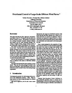
Figure 1 Wind retrieval algorithm up to Level 1B using information from ALADIN Mie and Rayleigh spectrometer data (blue), AOCS and platform data (green) and bias correction (red)
5
CONCLUSIONS
The first wind lidar in space ALADIN will be deployed on ESA´s Aeolus mission and will be operational in 2018. It is not only the first time that the space hardware of a high power UV laser and a Doppler wind lidar was developed, but also the on-ground processors for wind retrieval,
RETRIEVAL
The wind retrieval algorithms are described in detail in the respective Algorithm Theoretical
3
EPJ Web of Conferences 176, 02010 (2018) https://doi.org/10.1051/epjconf/201817602010 ILRC 28
calibration and bias correction schemes are novel, i.e. without heritage from earlier space missions. In order to develop, test and optimize the retrieval algorithms before launch, significant effort was undertaken in developing a representative E2S and chain of processors from Level 0 to Level 2 as well as in pre-launch campaigns with the A2D. Nevertheless all algorithm teams and also data product users should be prepared for surprises and serendipity. ACKNOWLEDGEMENTS Funding for the development of the E2S and L1B processor was provided by ESA and DLR. The first versions of the E2S and L1B were developed by MDA, Canada. References [1] European Space Agency ESA, 2008: ADMAeolus Science Report, ESA SP-1311, 121 pp. [2] European Space Agency ESA, 2016: ADMAeolus Mission Requirements Documents, AE-RP-ESA-SY-001, Issue 2, 16/11/2016, 57pp. [3] Reitebuch, O., 2012: The space-borne wind lidar mission ADM-Aeolus. in Atmospheric Physics – Background, Methods, Trends. U. Schumann (Ed.) Springer Series on Research Topics in Aerospace, 815-827. [4] Reitebuch, O., 2012: Wind lidar for atmospheric research. in Atmospheric Physics – Background, Methods, Trends. U. Schumann (Ed.) Springer Series on Research Topics in Aerospace, 487-507. [5] Dabas, A., Denneulin, M.-L., Flamant, P., Loth, C., Garnier, A., Dolfi-Bouteyre, A., 2008: Correcting winds measured with a Rayleigh Doppler lidar from pressure and temperature effects. Tellus 60A, 206-215. [6] Tan, D., Andersson., E., de Kloe, J., Marseille, G.-J., Stoffelen, A., Poli, P., Denneulin, M.-L., Dabas, A., Huber, D., Reitebuch, O., Flamant, P., Le Rille, O., Nett, H., 2008: The ADM-Aeolus wind retrieval algorithms. Tellus 60A, 191-205. [7] Reitebuch, O., Lemmerz, C., Nagel, E., Paffrath, U., Durand, Y., Endemann, M.,
4
Fabre, F., Chaloupy, M., 2009: The Airborne Demonstrator for the Direct-Detection Doppler Wind Lidar ALADIN on ADMAeolus. Part I: Instrument Design and Comparison to Satellite Instrument. J. Atmos. Ocean. Tech. 26, 2501-2515. [8] Marksteiner, U., Reitebuch, O., Rahm, S., Nikolaus, I., Lemmerz, C., Witschas, B., 2011: Airborne direct-detection and coherent wind lidar measurements along the east coast of Greenland in 2009 supporting ESA’s Aeolus mission, Proc. of SPIE Europe Int. Symposium Remote Sensing, 8182, Prague, Czech Republic, 81820J, 1-8. [9] Reitebuch, O., Lemmerz, C., Marksteiner, U., Rahm, S., Schäfler, A., Witschas, B., Emmitt, G.D., Greco, S., Kavaya, M.J., Gentry, B., Neely III, R.R., Schüttemeyer, D. (2016): Airborne wind lidar observations in the North Atlantic for preparation of the ADM-Aeolus validation. Proc. 18th Coherent Laser Radar Conference CLRC, Boulder, USA. [10] Reitebuch, O. et al., 2012: Final Report of ADM-Aeolus Campaigns 2004-2012. CD with final report, technical notes, dissertations, peer-reviewed papers, and final meeting handouts. Contract No. 18366/04/NL/MM, 15.06.2012. [11] Noveltis, 2013: A Surface Reflectance Database for ESA's Earth Observation Missions (ADAM). NOV-3895-NT-12403. Ed. 2, Rev. 1. from http://adam.noveltis.fr/ [12] Witschas, B. 2011: Analytical model for Rayleigh-Brillouin line shapes in air. Appl. Opt. 50, 267-270. [13] Paffrath, U., Lemmerz, C., Reitebuch, O., Witschas, B., Nikolaus, I., Freudenthaler, V., 2009: The Airborne Demonstrator for the Direct-Detection Doppler Wind Lidar ALADIN on ADM-Aeolus. Part II: Simulations and Rayleigh Receiver Radiometric Performance. J. Atmos. Ocean. Tech. 26, 2516-2530. [14] Reitebuch, O., Huber, D., Nikolaus, I., (2014). Algorithm Theoretical Basis Document ATBD: ADM-Aeolus Level 1B Products, AE-RP-DLR-L1B-001, V. 4.1, 18.7.2014, 93pp.