Automated Generalisation New Technology ..... are built on on top of the Gothic technology: LAMPS2 for map production, and Integrator for access to Gothic.
AGENT Project: Automated Generalisation New Technology Sylvie Lamy1, Anne Ruas1, Yves Demazeau2, Christof Baeijs2, Mike Jackson3, William Mackaness4, and Robert Weibel5 1 Institut Geographique National, Laboratoire Cogit, Saint-Mande, France 2 INPG, LEIBNIZ/IMAG, Grenoble, France 3 Laser Scan, Cambridge, UK 4 Department of Geography, University of Edinburgh, Edinburgh, Scotland 5 Department of Geography, University of Zurich, Zurich, Switzerland Introduction Objectives of AGENT project The purpose of AGENT is to produce an innovative map design software based on multi-agent technology . This comes at a time of increasing understanding in map generalisation, together with sophisticated software techniques for implementation. An important industrial consequence is that the autonomous design and display of maps according to themes and scales specific to the users’ needs at multiple scales are within reach. More precisely, the project will achieve the definition and modelling of behaviours of "geographical agents and structures" in the context of generalisation. This includes mechanisms to select and to display agents, mechanisms to validate agents’ actions, and the definition of strategies and dynamics that resolve competition among agents. In order to validate the methodological research, the project will focus on two prototypes for the fully automated design of multi-scale thematic representations: a professional tool and a public information desk [Lamy,1998] . Scope and structure of the paper In this paper we present the main base-classes of our generalisation model, the way that they will interact, and the mapping with the actual Laser-Scan platform in response to the questions : "How is the agent paradigm used? How will the system work?" The use of multi-agent system in the context of generalisation is first presented. The next part is devoted to the high level design of the global system with a description of the “geographical agents” and their life-cycle. Then, the convergence of the system is studied. Implementation work onto Laser-Scan Platform is presented in section 5. The last part presents the perspectives of work until the end of the project.
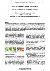
AGENT is part of the ESPRIT Long Term Research programme. It started on the 1st of December 1997 and will last three years. The partners are : Institut Géographique National (France), Laser-Scan Ltd (UK), Institut National Polytechnique de Grenoble (France), University of Edinburgh (UK), University of Zurich (Switzerland). The use of muti-agent system to solve Map Generalisation Map generalisation Generalisation is the process that aims at simplifying geographical information to make it meet the users’ needs, which means the enhancement of important information as well as the removal of unnecessary one. That simplification concerns entities (preservation, removal or grouping of objects) and their geometry (preservation or removal of geometric information such as location or shapes). [Lamy,1998] [Figure 1] shows three extracts of maps at different scales. By example, that Figure 1b and 1c could be derived from Figure 1a. This can be achieved by a mix of generalisation techniques (such as selection, merging, displacing, symbolising, simplification).
1:25 000
1: 100 000
1: 250 000
Figure 1 : Generalisation examples
Getting the right 'mix' of methods has revealed map design to be a complex spatial decision making process that operates at a number of design levels. Some operations occur at very local levels (micro level) whereas other operations such as displacement or selection are contextual and thus need to be applied to a set of geographical objects (meso level). The overall homogeneity of the map refers to an higher level (macro level) We therefore require a framework that enables us to model design at various levels of granularity, from the map as a whole through to the fine detail. It is the absence of this framework that has stymied progress in autonomous systems and why existing systems typically require intensive interaction with the user [Lamy,1999]. Multi-Agent Systems for generalisation The use of expert systems is limited by the near impossibility to develop a set of rules that would be large enough to foresee all situations that could occur, that could assess the competing rules, and provide coherent solutions. Multi-Agent Systems (MAS) provides autonomy by enclosing knowledge in the agent structure, while ensuring global consistency. In a MAS, entities, called agents, interact with one another. Agents have individual capabilities, that turn them into autonomous agents aiming at solving a given problem. An agent has goals to reach and mechanisms to trigger in order to reach its goals. Agents can communicate, co-operate, co-ordinate, and negotiate with one another, to satisfy both their individual goals and the goals of the overall system. An agent goes continuously through a perception-reason-decision-action cycle until its goals are satisfied, which means that it has reached a stable equilibrium state [Demazeau 97]. For generalisation purpose we can define a set of agents whereby each agent is capable of performing a set of specific tasks pertinent to map design. The operations of each agent are being constrained by what is ‘acceptable design’. Acceptable design born from the idea of a ‘design policy’ at a number of conceptual levels, constraining/modifying the activities of the individual - defining what is acceptable. The agents work together, collectively, sharing in their successes and failures, the goal is a distributed set of activities that results in the construction of a map, having specified scale and theme. Agents are not considered to be a utopia that obviates the need to tackle many of the problems identified by recent research in map generalisation. However they do offer a more transparent means by which we can model the complexities of map generalisation, in particular the often competing goals of map design and the complexities of grouping phenomenon in a meaningful way. [Lamy,1999]. Agents for generalisation Micro and Meso agents The phenomenological approach (geographical entities are agents) [Hangouet, 98] was given preference, being the most natural way to model generalisation through the MAS paradigm.
l
Agent Agent attributes
l
l
Agent goals
l
l
Agent knowledge
l
Geographical object Nature, characteristics Respect of constraints Set of algorithms Possible behaviors
Figure 2 : Agent modelling
For instance, an object “Building” will be viewed in MAS as an micro-agent which has to respect its own constraints (as minimal size, and form preservation). If one or several constraints are not satisfied, it will have the capabilities to chose and trigger one of its behaviours (e.g. amplification). But a building cannot decide to remove itself because of a too high density. Sometimes all particular goals (as minimal size) cannot be satisfied at the same time for a group of micro-agents, and an higher view is needed to guide the process. In such cases, organisation (set of agents) will be used. The organisation can change its agents’ goals, send them information, or give them orders (a building can be ordered to be eliminated) [Ruas, 99]. Such orders could be given only while organisations behaves as an agent, with its own goals to reach (A goal for an organisation of buildings may be to reduce its density), capabilities to trigger its behaviour. As organisation concern an higher level than micro-agent, we call them in our model “meso-agent”. In other words, organisations (or meso-agent) are structures which qualify the space and aim at guiding the process. They are responses to contextual operations and to the modelling of the generalisation strategies as well. Organisations give the framework that is required to model the different levels of abstraction (micro, meso and macro levels) as mentioned above. Agents’ life-cycle Agents can become active when they act autonomously and chose the way to generalise by themselves or reactive when they are ordered by an upper-layer meso-agent. In the first case, agents have a number of methods in order to implement them as autonomously acting entities generalising themselves and their map environment. Alternatively they can obey orders to execute plans given to them by organisations. In an autonomous state, an agent aims at reaching its own goals that means to satisfy a set of constraints : its current happiness will therefore depend on the current degree of satisfaction of its constraints. Constraint can be of different types: graphic, topological, structural, or Gestalt [Weibel, 98]. They can act at different levels: micro (minimum size), meso (proximity), or macro (global density). The flexibility of the system will be given by changing the goals of the agents from new map specification (if scale decreases, minimal size has to increase). Constraints must be supported by specific measures (one or several) to be characterised. The examples of the next paragraphs are extracted from .[AGENT report, University of Edinburgh]. Let’s take the constraints which could be applied to a building and a district for 1:50000 scale maps :
Size constraint
Granularity
Accuracy constraint
Density
Building Constraints Building should have a minimum size to be legible. This size depends on scale and symbol thresholds the length of the edges constituting the boundary must not be less than a threshold, which itself depends on the specifications of the map. The absolute position of a building should be preserved as much as possible. District Constraints Density should not be too high
Area:
Building Goals > 300m2
Minimal_lengh_of edge > 20m
Hausdorff distance: initial position)
< 20m (from
District goals Density : OK Reactive Agent autonomous Agent Obey
Figure 5:Active and reactive states
Some elements to ensure the system will converge We have to integrate some mechanisms able to ensure that the system will converge to a solution (perhaps not towards an ideal solution, but in every case towards an “acceptable” solution one), or more surely mechanisms that will detect that the system cannot converge according to the current problem configuration or generalisation context. These convergence related elements are located at different levels in the proposed approach. At the micro-agent level, two elements can guide to the conclusion that an agent cannot run infinitely : • In its reactive state the micro-agent can be viewed as a slave (non-local decision making), a single imposed plan is executed, and the micro-agent is afterwards put in a final state with respect to its autonomy. • In its active state, the activity of the micro-agent stops when the agent has reached a threshold of happiness (and not when it meets its ideal state). Moreover, micro-agent plans contain a finite number of generalisation algorithms to try. The control is sent back to the meso-agent at the higher level if the execution of all the algorithms of the plan does not lead to an improvement of its happiness. At the meso-agent level, meso-agents are able to observe the set of agents they control. As no problem of termination of processes can occur at a micro-agent level, the unique remaining problem can be that a majority of micro-agents sends back a failure to reach a better happiness. In terms of agents this case can be solved, • at the meso level locally, by giving reasoning capabilities to meso-agents to modify the micro-agent society (elimination, aggregation) until improvement of the solution is reached at a more global level, and by negotiation with other meso-agents • at the macro-level by modifying the constraints criteria (quality of the solution ...) [AGENT report, INPG]. Use of Laser-Scan Technology in the Agent Project Laser-Scan technology for MAS Gothic is the name for Laser-Scan’s state of the art spatial database technology. Gothic has many key technical features of which the most fundamental are that it is object-oriented, versioned, spatially indexed (dynamically), and topologically structured (dynamically). AGENT project will mainly use the two following applications that are built on on top of the Gothic technology: LAMPS2 for map production, and Integrator for access to Gothic over the Internet / Intranet. Object-Orientation in the context of Gothic’s geospatial database has considerable overlaps with a Multi-AgentSystems philosophy. A key concept of OO in Gothic, is that functionality is encapsulated with the data itself, making the transition between object and agent straightforward and relatively narrow. However, where OO and agent differ is that whilst an object has no choice but to execute its method in response to a message, an agent has the ability to negotiate - i.e. to communicate with the sender, perhaps executing its behaviour or perhaps not. A key component of the transition between object-based and agent-based technology is the definition of an interaction protocol - a communication mechanism whereby rather than objects instructing each other, they inform, persuade, advise, bargain, warn, order etc. - i.e. they interact with one another as agents. The proposed modelling has already begun being implemented onto Lamps2, using the pre-existing objectoriented technology [AGENT report, Laser-Scan].
Agent Demonstrators and Laser-Scan Technology The Agent project requires two demonstrators. One demonstrator, namely P1 illustrates the use of multi-agent generalisation in a professional cartographic system for use by a national or commercial mapping agency, whilst P2 demonstrates contextual generalisation in an Internet environment. A different Laser-Scan application will be used as the basis for each demonstrator, with LAMPS2 providing the platform for the professional cartographic system, and Integrator Java Edition, the platform for the Internet solution. Each application offers a different suite of tools aimed at specific sectors of the GIS market, and are each appropriate for the two Agent project demonstrators. Thus LAMPS2 provides a variety of data modelling, capture, editing, and processing tools typical for map production, whilst Integrator Java Edition, compliments LAMPS2 with the necessary client and server tools for delivering such information over the Internet using Java and CORBA. P2 Internet access
P1 Multi-scale Production On-demand Transportation Mapping
1:50K Derived Topographic Mapping
Gothic Database MULTI-AGENT SYSTEM
1:10K Data Transportation
Specifications contained
Classes: Symbology: Constraints: proximity accuracy
Export
Hardcopy
within database Figure 6 : AGENT prototypes
Perspectives The use of agent methodologies, constraints, cartometric techniques for evaluation, has already being studied during the first year of the project. Micro-agent structure as well as micro-agent specific classes (buildings, roads) with their appropriate behaviours have been implemented. A contextual including meso-agent such as district or road network should be available within next months. These research will be carried until the end of the project to improve and enhance the first prototype, especially, • to improve the agents’ cognitive function (decision function) • to include more classes • to include more behaviours. The critical other research areas in which AGENT will study from now are : • The strategic process : how to find an appropriate sequence of operations? How to enable backtracking? • The taking into account of macro-constraints as global density,… • The communication and decision functions between several meso-agents. References AGENT reports Demazeau, Y. Steps towards Multi-Agent Oriented Programming, 1st International Workshop on Multi-Agent Systems, IWMAS 97, Boston, 1997. (slides) Hangouet, J.-F., Approche et méthodes pour l’automatisation de la généralisation cartographique ; application en bord de ville, Thèse de Doctorat de l’Université de Marne-La-Vallée, Saint-Mandé, 1998 (in French)
Lamy, S. , AGENT project, 4th-EC GIS Worshop , Budapesr, 1998 Lamy, S. & all, The Application of Agents in Automated Map Generalisation, ACI 99, Ottawa, 1999 Ruas, A. Strategies de généralisation de données géographiques à base d’autonomie et de contraintes, Thèse de Doctorat de l’Université de Marne-La-Vallée, Saint-Mandé, 1999 (in French) Weibel, R., 1996, A Typology of Constraints to Line Simplification: Proceedings of the 7th International Conference on Spatial Data Handling, p. 533-546.