Geologica Belgica International Meeting Aardk. Mededel., 2002, 12, 193-195
Building data-bases in view of the large-scale hydrogeological modelling of Flanders J. Cools1, Y. Meyus, O. Batelaan & F. De Smedt 1. Department of Hydrology and Hydraulic Engineering, Vrije Universiteit Brussel, Pleinlaan 2, B-1050 Brussel,
[email protected]
ABSTRACT Existing groundwater models in Flanders (Belgium) are local small-scale models, which serve various goals and therefore often lead to conflicting results. Therefore, a (hydro)geological database and isohyps, isopach and occurrence maps are developed. The database and the maps are based upon the new numerical, hydrogeological code for Flanders (HCOV). The general purpose of the large-scale model is to stimulate integrated groundwater management. KEYWORDS Belgium, Flanders, Geographic Information System (GIS), Groundwater Management, Hydrogeology
Introduction
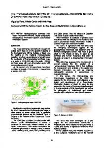
Description of the study area Belgium is a federal country consisting of three largely independent regions: Flanders, Wallonia and the Brusselscapital region. Flanders is situated in the North of Belgium and covers an area of 13.524 km² (44 % of Belgium), bordered by the Netherlands and France (Fig. 1). Flanders has a temperate, oceanic climate. The average annual rainfall is 780 mm and the average temperature is 9,8°C (Alexandre et al., 1992). The major rivers in Flanders are the Scheldt and its main tributaries (Dender, Zenne, Dijle, Demer, Nete and Leie) with a catchment area of 19.141 km². The Meuse with a catchment area of 31.181 km² is only partly covering Flanders inasmuch as it forms the administrative border in the East. The Ijzer, with a catchment area of 1.116 km², drains the South-West of Flanders (De Smedt et al., 1992). N
Netherlands
The present groundwater policy of most European countries is based on administrative and legislative tools. Policy decisions and measures, based on assumptions, are prone to misjudgement. Therefore, integrated groundwater management requires decision-supportive technological tools. These will be provided by the Flemish Groundwater Model (Vlaams Grondwater model - VGM), an environment in which the MODFLOW groundwater modelling code (McDonald and Harbaugh, 1988) is linked to GIS (Geographic Information System) and WETSPASS, a distributed groundwater recharge methodology (Batelaan and De Smedt, 2001).
F 0 20
8
Netherlands
2
North Sea
1 9 A N D R 3E 7 6 BRUSSELS
L
S
4
5
40 Km
France
Wallonia
Fig. 1. Map of Flanders and its main rivers. The bold lines represent the nine subregions used in the model.
Purpose of the VGM is to create an environment, in which a regional insight in the groundwater resources in Flanders can be obtained. More in detail, the VGM could be used to calculate the general direction and magnitude of groundwater flow and to quantify groundwater recharge, discharge and storage. Furthermore, the impact of external influences and management decisions can be assessed, on a regional scale. The VGM is additionally to be used as a starting point and frame for other, more detailed or externally executed, groundwater flow and pollution transport simulations. Hence, the Flemish Groundwater Model will be an essential tool for further integrated groundwater management.
The VGM-environment Executing large-scale models requires long calculation times and huge computer storage capacities. The Flemish region was therefore divided in nine subregions (geographic location on Fig. 1; position in VGM-environment on Fig.2) along existing hydrogeological boundaries (main rivers, water divides or dominant strata outcrops). However, not all subregions have unique boundaries, resulting in overlapping zones that will be necessary to couple these submodels. The VGM-environment (Fig.2) consists of these nine submodels, which are linked to a recharge model, external
193
the requested level of detail, the second digit (subunits) and the last digit (base units) can be specified.
models (e.g. agricultural or economical models) and hydrogeological data. isohyps & isopach maps
Geological database
boundary conditions
Recharge model
Table 1. main units of the HCOV hydrogeological code HCOV Description main units 0000 Undetermined 0100 Quaternary aquifer system 0200 Campine aquifer system 0300 Boom aquitard 0400 Oligocene aquifer system 0500 Bartoon aquitard system 0600 Ledo-Paniselian-Brusselian aquifer system 0700 Paniselian aquifer system 0800 Yperian aquifer 0900 Yperian aquitard system 1000 Paleocene aquifer system 1100 Cretaceous 1200 Jurassic-Trias-Perm 1300 Paleozoic
hydrogeological parameters
VGM
1
2
3
4
5
6
External models
7 8 9 9 linked submodels
Figure 2. The VGM environment: MODFLOW groundwater models linked in a GIS-environment to hydrogeological data, a recharge model and external models. The database contains all existing geological and hydrogeological data and parameters for each subregion. The hydrogeological data, necessary for the development of a groundwater model is created from (existing) chronostratigraphical data, based on the HCOV code (Hydrogeologische Codering van de Ondergrond van Vlaanderen), the newly developed hydrogeological code for Flanders. Furthermore, isohyps (depth of formation basis), isopachs (thickness) and occurrence maps are produced for each hydrogeological unit. This centralised database and the hydrogeological model layers of Flanders will become available at the centralised, public database of the Flemish administration DOV – Databank Ondergrond Vlaanderen (http://dov.vlaanderen.be).
Hydrogeological modelling: methodology Prior to hydrogeological modelling of Flandres, data has to be collected. Therefore, a database is developed from the existing database used by the Flemish Administration for Natural Resources and Energy (ANRE). After validation, the total number of borehole profiles is 9000, of which 74 % originally public domain. Technical aspects of this relational database are set out in Cools et al. (2002). New data was mostly collected outside of the Flemish borders. This ‘foreign’ data was not known in Flanders, but is still part of the same groundwater system, as shown in Fig. 1. Besides this geological database, the existing geological maps – and folios - were used, such as the newly revised and digitised Tertiary surface maps, the ‘old’ Quaternary geological maps and the maps found e.g. in Demyttenaere (1988), Houthuys (1990) and Maréchal (1992).
Hydrogeological code of the underground in Flanders (HCOV) As no standard tool for the characterization of the underground in Flanders existed, the exchange and comparison of groundwater data was very elaborate. Therefore, a steering committee composed of representatives of the Flemish universities, the Belgian Geological Survey, drinking water companies, Belgian research centers and the Flemish Administration, Department Water, Environment and Nature (AMINAL), reviewed the existing codes and created a new uniform and widely accepted hydrogeological code for Flanders (HCOV) (Meyus et al., 2001).
Through combination of the point data and the geological maps, the hydrogeological model layers (isohyps and isopach maps) are produced per HCOV-unit with the help of digital interpolation and analogue interpretation techniques. For Tertiary formations and older, isohyps maps are developed prior to isopach maps as the depth of the basis of these formations is known more accurately than the thickness. With the developed, interpolated grids, the thickness of a formation is then calculated as the top of a formation (i.e. the basis of the upper lying formation) minus the basis of that formation. For Quaternary formations, isopach maps are developed first. Substraction of the thickness of the first, most shallow formation from the topography (DEM) results in its basis. From this basis , the method can be repeated for the second shallowest layer.
Notwithstanding its resemblance with the stratigraphical code, HCOV is a purely hydrogeological code based on hydrogeological properties, such as conductivity and water storage capacity. HCOV is recognizable, complete for Flanders and includes all prevailing strata from primary to quaternary period. The code is numerical (4 digits), hierarchical (3 levels) and chronological (numbering from young to old strata). The first 2 digits represent the main units (14 classes from 0000 to 1300; Table 1). Depending on 194
MCDONALD, M.G. & HARBAUGH, A.W., 1988. A modular three-dimensional finite-difference ground-water flow model – Techniques of Water resources investigations 06-A1, USGS, Book 6, chapter A1. 576 p. MEYUS, Y., DE SMET, D., DE SMEDT, F., WALRAEVENS, K, BATELAAN, O. & VAN CAMP. M., 2000a. Hydrogeologische codering van de ondergrond in Vlaanderen. @wel 8 - water. http://www.wel.be (in Dutch). MEYUS, Y., VAN DAELE, T., BATELAAN, O. & DE SMEDT, F. 2000b. Concept Vlaams GrondwaterModel (VGM). Eindrapport. Report by order of Flemish Administration, Department Water, Environment and Nature., Brussel, 90p (in Dutch).
Conclusions and further development The (hydro)geological database and the isohyps, isopach and occurrence maps which are developed in this article are only a lumped way to represent reality. Nevertheless, the obtained hydrogeological maps can be used as model layers in a regional groundwater model. This public database can be used to gain an insight in the Flemish groundwater resources, to establish causal relations, to predict the impact of external influences or management decisions and to use it as a figure for more detailed or externally executed groundwater flow modelling. Although the hydrogeological maps and database is developed, the VGM-environment (as depicted in Fig. 2) is to be completed prior to the development of a groundwater model. Data on boundary conditions (river data, pumping rates, recharge rates, and piezometric data) exist, but is not centralized and not standardized. Recharge rates will be calculated with the distributed model WetSpass (Batelaan and De Smedt, 2001). Likewise, a Flanders-covering digital elevation model (DEM) will be finished shortly. Acknowledgements This research is financed by the Flemish Administration, Department Water, Environment and Nature (AMINAL-water). Furthermore, we acknowledge all institutes and companies that shared their (hydro)geological data and the research institutes that collected, interpreted and digitised these data. Likewise, the Belgian experts of the steering committee are acknowledged for their valuable remarks.
References ALEXANDRE, J., ERPICUM, M. & VERNEMMEN, C., 1992. Klimaat. In: Denis, J. (Ed.) Geografie van België. Gemeentekrediet, 87-129 (in Dutch). BATELAAN, O. & DE SMEDT, F., 2001. WetSpass: a flexible, GIS based, distributed recharge methodology for regional groundwater modelling. In: Gehrels, H., Peters, J., Hoehn, E., Jensen, K., Leibundgut, C., Griffioen, J., Webb, B. and Zaadnoordijk, W-J. (Eds.) Impact of Human Activity on Groundwater Dynamics, IAHS Publ. No. 269, pp. 11-17. COOLS, J., MEYUS, Y., BATELAAN, O. & DE SMEDT, F. 2002. A large-scale hydrogeological database and groundwater model for Flanders: a tool for integrated groundwater management. In: Ramirez, J. (Ed.) Hydrology Days 2002 Proceedings, Colorado State University, Fort Collins, Colorado, USA, 35-46. DEMYTTENAERE, R. (1988). De post-paleozoïsche geologsiche geschiedenis van Noord-België. PhD-dissertation, KULeuven, Belgium (in Dutch). DE SMEDT, P., BIRON, J.P., WEMANS, G., 1992. Hydrologie. In: Denis, J. (Ed.) Geografie van België. Gemeentekrediet, 217-241 (in Dutch). ENVIRONMENTAL SYSTEMS RESEARCH INSTITUTE (ESRI). The Arc/Info version 7.1. and ArcView 3.2 software package documentation. ESRI, Redlands, California, USA. HOUTHUYS, R. (1990). Een vergelijkende studie van de afzettingsstructuur van getijdezanden uit het Eoceen en van de huidige Vlaamse banken. Aardkundige mededelingen, nr. 5 (in Dutch). MARÉCHAL, R. 1992. Quaternary geology and lithology of the superficial layers. – Second atlas of Belgium, map II.3.
195