Combining Incompatible Spatial Data Carol A. Gotway and Linda J. Young Global positioning systems (GPSs) and geographical information systems (G ISs) have been widely used to collect and synthesize spatial data from a variety of sources. New advances in satellite imagery and remote sensing now permit scientists to access spatial data at several different resolutions. The Internet facilitates fast and easy data acquisition. In any one study, several different types of data may be collected at differing scales and resolutions, at different spatial locations, and in different dimensions. Many statistical issues are associated with combining such data for modeling and inference. This article gives an overview of these issues and the approaches for integrating such disparate data, drawing on work from geography, ecology, agriculture, geology, and statistics. Emphasis is on state-ofthe-art statistical solutions to this complex and important problem. KEY WORDS: Change of support; Data assimilation; Ecological inference; Modi able areal unit problem; Multiscale processes; Spatially-misaligned data.
1.
INTRODUCTION
One of the most challenging and fascinating areas in spatial statistics is the synthesis of spatial data collected at different spatial scales. Advances in satellite imagery and remote sensing now permit scientists to access spatial data at several different resolutions. For example, data from Landsat thematic mapper (TM) scenes have a resolution of 30 m2 (the size of the area on the ground represented by each unit in the image), the low-cost advanced very-high-resolution radiometer (AVHRR) has a much coarser resolution (2.2–16 km2 ), and aerial photographs can be digitized to a very ne resolution (1 m2 or smaller). The advent of the Internet has led to an explosion in the number of readily available datasets. Studies working with disparate data at multiple scales have become common, causing increased concern over issues surrounding scale. Recent advances in geographic information systems (G ISs) make it possible to use spatial data from different resolutions and combine them with other types of disparate spatial information (e.g., networks, roads, utility pipelines, census tract information). Users of spatial information are frequently faced with the problem of how best to integrate such information. The overall problem of “incompatible” spatial data has been encountered in several elds of study, and numerous terms have been introduced to describe one or more facets of the problem as well as various solutions to it. These terms include the ecological inference problem, the modi able areal unit problem, spatial data transformations, the scaling problem, inference between incompatible zonal systems, block kriging, pycnophylactic geographic interpolation, the polygonal overlay problem, areal interpolation, inference with spatially misaligned data, contour reaggregation, multiscale and multiresolution modeling, and the change of support problem. In this article, we give a multidisciplinary history of this problem, with a description of early proposed solutions. We then review Carol A. Gotway is Senior Mathematical Statistician, National Center for Environmental Health, Centers for Disease Control and Prevention, Atlanta, GA 30333 (E-mail:
[email protected]). Linda J. Young is Professor, Department of Biometry, University of Nebraska, Lincoln, NE 68583 (E-mail:
[email protected]). The authors gratefully acknowledge all of the authors whose work is represented and discussed in this article, who have made outstanding contributions to a persistent and perplexing problem. They especially thank Brad Carlin, Noel Cressie, Hsin-Cheng Huang, Chris Wikle, and Jeremy Aldworth, who were willing to share their work and ideas, some of which has not yet been published. Finally, they thank Noel Cressie for his review of this article during its infancy stages. His comments and suggestions, and his willingness to review a crude draft of a lengthy manuscript, are much appreciated.
more recent statistical approaches, emphasizing the underlying assumptions and evaluating the progress made toward combining incompatible spatial data. 2.
A HISTORICAL PERSPECTIVE
The choice of an appropriate scale for the study of spatial processes is an extremely important one because mechanisms vital to the spatial dynamics of a process at one scale may be unimportant or inoperative at another. Moreover, relationships between variables at one scale may be obscured or distorted when viewed from another scale. This is particularly true in the study of human, animal, and plant populations and has led many researchers in agriculture, geography, sociology, statistics, ecology, and the earth and environmental sciences to consider scale issues in detail (Fair eld Smith 1938; Yule and Kendall 1950; Robinson 1950; Selvin 1958; Matheron 1963; Hannan 1971; Moellering and Tobler 1972; Ghil, Cohn, Tavantzia, Bube, and Isaacson 1981; Morganstern 1982; Openshaw 1984; Turner, O’Neill, Gardner, and Milne 1989; Fotheringham and Wong 1991; Daley 1991; Richardson 1992; Levin 1992; Cressie 1993a, 1996; Jelinski and Wu 1996; King 1997). 2.1
The Modi’ able Areal Unit Problem
In many instances, spatial aggregation is necessary to create meaningful units for analysis. This latter aspect was perhaps best described by Yule and Kendall (1950, p. 312), who stated that “geographical areas chosen for the calculation of crop yields are modi able units and necessarily so. Since it is impossible (or at any rate agriculturally impractical) to grow wheat and potatoes on the same piece of ground simultaneously we must, to give our investigation any meaning, consider an area containing both wheat and potatoes and this area is modi able at choice.” Geographers have long had an appreciation for the problems associated with the use of modi able units. These problems led Openshaw and Taylor (1979) to coin the term modi able areal unit problem, now often referred to simply as the MAUP. Gehlke and Biehl (1934) rst documented that statistical inference could change with scale using two census tract variables. They found that when contiguous census tracts were
632
© 2002 American Statistical Association Journal of the American Statistical Association June 2002, Vol. 97, No. 458, Review Paper
Gotway and Young: Combining Incompatible Spatial Data
grouped to form larger areas, the magnitude of the correlation coef cient between the two variables increased. However, when random census tracts were grouped, the correlations were unaffected by the group size. The impact of different grouping methods, such as random, by proximity, or by values of either the dependent or independent variable, was then studied by Yule and Kendall (1950), Blalock (1964), and Clark and Avery (1976). When random grouping was used, there was no systematic effect on the correlation coef cient or on the estimated slope parameter from simple linear regression. When the grouping was based on values of the dependent variable, both the correlation coef cient and the estimated slope parameter increased with scale. If the grouping criterion was based on values of the independent variable, then the correlation coef cient increased with increasing aggregation, but grouping had no systematic effect on the estimated slope parameter. Finally, when proximal units were grouped, the estimates of both the correlation coef cient and the slope parameter increased with the level of grouping, although the correlation coef cient increased only up to a certain level of aggregation, after which the correlations began to decrease. To better understand the nature of the problem and to suggest ef cient groupings for geographical data, Openshaw and Taylor (1979) considered 99 counties in Iowa and constructed all possible groupings of these counties into larger districts. Their results were somewhat startling. When the correlation between the percentage of Republican voters and the percentage of elderly voters was considered, 12 districts could be contrived to produce correlations ranging from ƒ097 to C099. Moreover, no obvious relationship seemed to exist between the spatial characteristics of the districts and the variation in the resulting correlation coef cients. These studies illustrate that the MAUP is two interrelated problems. The rst problem concerns the different inferences obtained when the same set of data is grouped into increasingly larger areal units. Often referred to as the scale effect or aggregation effect, this has received the most attention by statisticians. The second problem, often termed the grouping effect or the zoning effect, considers the variability in results due to alternative formations of the areal units leading to differences in unit shape at the same or similar scales (Openshaw and Taylor 1979, 1981; Openshaw 1984; Wong 1996). Both issues can be, and often are, present in a single analysis. Theoretical reasons for the increase in correlations as the level of aggregation increases have been provided in the works of Robinson (1950), Prais and Aitchison (1954), Robinson (1956), and Cramer (1964) in the context of the simple linear regression model. Prais and Aitchison (1954) developed the use of grouping matrices to measure the grouping effects and suggested weighted least squares for unbiased estimation of the slope coef cient. This idea was extended by Williams (1976), Haitovsky (1984), and Arbia (1986) to more complicated grouping arrangements and the use of generalized least squares. However, the loss of ef ciency resulting from aggregation cannot be removed simply by using a weighted analysis. Thus correlation coef cients and signi cance tests based on aggregated data tend to be in ated. Areal weighting, rst suggested by Robinson (1956), is an effective solution to the MAUP only in very specialized situations (Thomas and Anderson 1965), and in general will not
633
solve the problem caused by the zoning effect. The effects of the MAUP go beyond such simple statistics as the variance and the correlation coef cient discussed here. Inferential problems also occur in multivariate regression analysis (Fotheringham and Wong 1991), Poisson regression (Amrhein and Flowerdew 1992), hierarchical random coef cient models (Goldstein 1995; Steel and Holt 1996), spatial interaction models (Putnam and Chung 1989), spatial autocorrelation statistics (Jelinski and Wu 1996), and undoubtedly in many other statistical models and estimation procedures. 2.2
The Ecological Fallacy
In epidemiology, the term ecological inference refers to the process of deducing individual behavior from aggregate data. This term is from Robinson (1950), who noted that in ecological correlation, the statistical object is a group of persons. He concluded that ecological and individual correlations are almost certainly not equal, leading him and others to question the results of numerous studies in which conclusions on individual behavior had been drawn from grouped data. Thus the ecological fallacy occurs when analyses based on grouped data lead to conclusions different from those based on individual data (Selvin 1958). The resulting bias is often called “ecological bias” (Richardson 1992; Greenland and Robins 1994). This is comprised of two components: aggregation bias due to the grouping of individuals and speci cation bias due to the differential distribution of confounding variables created by grouping (Morganstern 1982). These are analogous to the scale and zoning effects in the MAUP, and the ecological inference problem can be viewed as a special case of the MAUP and not the converse, as advocated by King (1997). Ecological bias has been well documented in the literature (Robinson 1950; Richardson, Stucker, and Hemon 1987; Piantadosi, Byar and Green 1988; Greenland and Morganstern 1989; Walter 1991; Richardson 1992; Klein and Freedman 1993), as have “inference rules” and “solutions” (Goodman 1959; Firebaugh 1978; Richardson 1992; King 1997). Cleave, Brown, and Payne (1995) and King (1997) have provided critical discussions of some of these in the context of contingency table analysis where individuals are divided into areal units (e.g., census tracts, voting districts), and then cross-classi ed by other variables (e.g., sex, race). Often the cause of speci cation bias is the failure to incorporate relevant spatial information about individuals (e.g., Klein and Freedman 1993). This type of analysis is not of primary interest here. Instead, our focus is on spatial data and methods for combining spatial data from disparate sources. 2.3
Sources of the Modi’ able Areal Unit Problem and Ecological Bias
The smoothing effect that results from averaging is the underlying cause of both the scale problem in the MAUP and aggregation bias in ecological studies. As heterogeneity among units is reduced through aggregation, the uniqueness of each unit and the dissimilarity among units is also reduced. There is, however, another mitigating factor: spatial autocorrelation. The decrease in variance is moderated by the positive autocorrelation among the original observations, and exacerbated by negative autocorrelation. Arbia (1986) and Cressie
634
Journal of the American Statistical Association, June 2002
(1993b) have illustrated the effect of autocorrelation on the variance of the sample mean. When areal units are similar to begin with, the aggregation process results in much less information loss than when the units are highly dissimilar. To further compound the problem, the aggregation process itself induces positive spatial autocorrelation, particularly if the aggregation process allows overlapping units (e.g., moving averages). Cross-correlations with variables in neighboring units also can affect the results (Wong 1996). The smoothing effect and resulting alterations in the spatial autocorrelation of the units are also sources of the zoning effect. The MAUP does not exist, or at least its effects are much less pronounced, when aggregation of areal units is performed in a noncontiguous or spatially random fashion. Only when contiguous units are combined, altering the spatial autocorrelation among the units, is the zoning effect of MAUP most apparent. Because the variation among the original areal units is not uniform over the entire region, merging smaller units is analogous to smoothing different combinations of spatial neighbors. Depending on the similarity of the neighbors, different zoning rules may lead to different analytical results. Thus, given the plethora of ways of combining even a relatively small number of spatial units, it is not hard to see how one could produce “a million or so correlation coef cients” as Openshaw and Taylor (1979) found. The complex facets of the smoothing effect can be very dif cult to sort out in any given application, leading to a vast literature on this problem. Some information is lost by aggregating and going to increasingly larger scales. Systematic effects, caused by either the aggregation aspect or the zoning aspect of the MAUP, depend on the spatial relationships among the original data values, the statistics being calculated, and the way in which the units are aggregated. Thus the effects of the MAUP and ecological bias that may occur in any particular application are often dif cult or impossible to ascertain. But this fundamental understanding of the problem makes it clear that any solution must nd a way to (1) account for or circumvent the loss of information due to aggregation and (2) relate the variation among the aggregated units to the variation among the original units composing each aggregate. Although dif cult, this can be done, as described in Sections 31 4, and 5. 2.4
the size or volume associated with each data value, but the complete speci cation of this term also includes the geometrical size, shape, and spatial orientation of the regions associated with the measurements (see, e.g., Olea 1991). Changing the support of a variable (typically by averaging or aggregation) creates a new variable. This new variable is related to the original one, but has different statistical and spatial properties. The problem of how the spatial variation in one variable associated with a given support relates to that of the other variable with a different support is the COSP. Table 1, modi ed from Arbia (1989), delineates some common COSPs. Both the ecological inference problem and the MAUP are just speci c COSPs. Many other terms have also been introduced to describe particular COSPs and solutions to particular COSPs including the scaling problem, inference between incompatible zonal systems, block kriging, pycnophylactic geographic interpolation, the polygonal overlay problem, areal interpolation, inference with spatially misaligned data, contour reaggregation, and multiscale and multiresolution modeling. Many of these are discussed in more detail in subsequent sections. COSPs may result when studying a single spatial variable or when trying to relate two spatial variables of different supports. For example, consider a retrospective epidemiologic study designed to measure the effect of air quality on mortality or morbidity. Often in such studies, only aggregate health data are available, re ecting cost, time, and con dentiality considerations. This is an area-to-point COSP, because aggregate data must be used to make inferences about individuals. Another COSP problem results when trying to link the exposure data to the health outcome information, because the two variables have inherently different scales. This serves to illustrate a more fundamental problem not alleviated by even the most sophisticated measurement process. Disease is speci c to an individual, but air quality varies over a continuum—how can these two different types of data be related in a way that permits valid inference?
The General Change of Support Problem
The different types of spatial data (point, line, area, surface), occurring naturally or as a result of the measurement process, potentially allow many ways of integrating these different types of spatial data. Arbia (1989) uses the term spatial data transformations to refer to situations in which the spatial process of interest is inherently of one form but the data observed are of another form, resulting in a “transformation” of the original process of interest. For example, sometimes the data are just not available at the desired scale of interest. Meteorologic processes occur over a continuum, but only point observations along such a surface can be recorded. Individuallevel inference may be desired, but to ensure data con dentiality, only aggregate data are made available. These situations and all of Arbia’s spatial data transformations are special cases of what is called the change of support problem (COSP) in geostatistics. The term “support” has come to mean simply
Table 1. Examples of COSPs We observe or analyze
But the nature of the process is
Examples
Point
Point
Point kriging; prediction of undersampled variables
Area
Point
Ecological inference; quadrat counts
Point
Line
Contouring
Point
Area
Use of areal centroids; spatial smoothing; block kriging
Area
Area
The MAUP; areal interpolation; incompatible/misaligned zones
Point
Surface
Trend surface analysis; environmental monitoring; exposure assessment
Area
Surface
Remote sensing; multiresolution images; image analysis
Gotway and Young: Combining Incompatible Spatial Data
3.
635
GEOSTATISTICAL SOLUTIONS TO THE CHANGE OF SUPPORT PROBLEM
Many of the statistical solutions to the COSP can be traced back to Krige’s “regression effect” and subsequent corrections used in mining blocks of ore in the 1950s (Krige 1951). These were more formally developed into the beginning of the eld of geostatistics by Matheron (1963). Point kriging is one solution to the point-to-point COSP, but geostatistics was really invented for more general COSPs. The basic geostatistical concepts of support and change of support have been presented by Clark (1979) and Armstrong (1999). More general solutions to change of support problems have been discussed by Journel and Huijbregts (1978), Chiles and Del ner (1999), and Cressie (1993a, 1996).
The solution to most COSPs requires spatial prediction. A common inferential problem is the prediction of Z4B5 from point samples Z4s1 51 Z4s2 51 : : : 1 Z4sn 5. In linear geostatistics, this predictor is called the P universal block kriging predictor b D niD1 ‹i Z4si 5, where optimal weights and is given by Z4B5 8‹i 9 are obtained by solving (Journel and Huijbregts 1978; Chiles and Del ner 1999) n X
kD1
‹k C4si 1 sk 5 ƒ
Block Kriging
Consider the process 8Z4s5 2 s 2 D 0, and 0 < 2 < 2. Other covariance functions could be used, (see, e.g., Handcock and Stein 1993; Gaudard et al. 1999). The parameters 1 and 2 can also be given prior speci cations. Independent uniform priors could be speci ed (e.g., Diggle et al. 1998), or instead a truncated Gaussian prior could be used for 1 (e.g., Royle, Berliner, Wikle, and Milliff 1997). The full conditional distributions for these parameters are usually not tractable, and so another algorithm (e.g., Metropolis–Hastings) must be used to sample from these distributions. In many applications, X describes a physical process, and for such cases it may be useful to model m D H Â. This second stage of the hierarchy, X Nm 4H Â1 Q4Á55, has been called the process model (Berliner, Royle, Wikle, and Milliff 1999), with the goal of this modeling step being a description of the true, unobserved process through physically motivated conditional distributions. Royle et al. (1997) and Berliner et al. (1999) used this stage to relate a surface wind eld 4X5 to the gradient of a pressure eld 4Â5. The components of the matrix H were based on differential equations that describe atmospheric dynamics involving pressures and winds. Wikle, Berliner, and Cressie (1998) and Wikle, Milliff, Nychka, and Berliner (2001) used a similar formulation to incorporate temporal variation as well as physical process constraints in describing the dynamics of a tropical wind process. A prior distribution for  may also be speci ed to re ect information and uncertainty about this parameter. When the measured locations are different from the state locations, K maps the measurements to the nearest state locations (Royle et al. 1997). Thus, if both Z and X have point support, then the aforementioned formulation is a solution to the point-point COSP. Wikle et al. (2001) showed how this model can be extended to combine spatial data at different scales. In their development of a space-time model of tropical ocean surface winds, high-resolution, satellite-derived wind estimates were observed at grid locations Ai , and lowerresolution wind data provided by major weather centers were observed at grid locations Ck . Prediction was desired at grid locations Bj , with —A— < —B — < —C —. For the conditional measurement equations, Wikle et al. (2001) assumed
and
£ ¤ ZA — KA 1 X1‘ A2
£ ¤ ZC — KC 1 X1‘ C2
N 4KA X1‘ A2 I5 N 4KC X1‘ C2 I50
Because the data ZA were at a ner resolution than the desired prediction grid, KA was taken to be an incidence matrix that mapped the conditional mean of these observations to the nearest prediction grid location. The data ZC were at a coarser resolution than the desired prediction grid, so KC operated by assuming that the measured data were smoothed versions of the true process. Each observed point was a weighted average of the nine closest prediction points within a distance D. The variances of the measurement errors were allowed to differ, re ecting the different instrumentations used for measurement.
641
Additional hierarchical levels, similar to those discussed earlier, were used to describe the dynamics (both temporal and mechanistic) of the wind processes. Thus, one general Bayesian hierarchical model for a multiscale process has the following basic form: £ ¤ N 4KA X1‘ A2 DA 51 ZA — X1‘ A2
£ ¤ ZC — X1‘ C2 £ ¤ X — Â1 Á Â
DA known or the identity matrix3
N 4KC X1‘ C2 DC 51 DC known or the identity matrix3 N 4H Â1 Q4Á551
Q4i1 j5
D exp4ƒ 1 ˜si ƒ sj ˜ 2 51 1 > 01 0 < 2 < 23 N 4Â0 1 è 53
‘ A2
I G4aA 1 bA 53
‘ C2
I G4aC 1 bC 53
1
U 4a1 1 b1 53
2
U 4a2 1 b2 51
and where Â0 1 è 1 aA 1 bA 1 aC 1 bC 1 a1 1 b1 1 a2 , and b2 are speci ed. In actual applications, additional hierarchical structures may be used, different covariance models and prior distributions may be chosen, and some simpli cations may be required for implementation. [See Royle et al. 1997; Diggle et al. 1998; Wikle et al. 1998; Wikle et al. 2001 for applications and details on choices for the hyperparameters and details of the Markov chain Monte Carlo (MCMC) sampling used for inference.] An advantage of this type of speci cation is that the joint distribution of Z and X (and, in particular, their crosscovariance matrix) does not have to be speci ed and modeled. Nevertheless, assumptions about the covariance between X and Z are being made. Consider just the rst two stages of the models described earlier, Z—X N 4KX1‘ 2 I5 N 4H Â1 Q5. If K is an incidence matrix, then and X the implicit assumptions are that cov4Z4si 51 Z4sj 55 D ‘ 2 C cov4X4uk 51 X4ul 55, where 4uk 1 ul 5 is the node closest to 4si 1 sj 5, and cov4Z4s51 X4u55 D cov4X4s51 X4u55. Although more levels in the hierarchy are usually considered, and some of these may also allow spatial dependence, assumptions of diagonal covariances and sparse mapping matrices may result in simple approximations to potentially complex multiscale relationships. As with the multiscale tree models described earlier, these hierarchical spatial models do not account for changes in support that result from changes in resolution. It may be possible to formulate COSP models by relating both processes to an underlying process with point support, …4s5. Then, if Z is measured with support A and X is measured with support B, 6Z — X1‘ 2 7
N 4WA X1 èA… C ‘ A2 I 5
and X
N 4Ì4B51 èB… 5
642
Journal of the American Statistical Association, June 2002
with èS… having 4i1 j5th element Z Z C… 4u1 v5 du dv=—Si ——Sj — Si
Sj
and WA having 4i1 j5th element —Ai \ Bj —=—Ai — to ensure proper relationships between the means of …4s51 Z4Ai 5, and X4Bj 5. Suppose instead that speci cation of the joint distribution is not problematic. Assume that Z4s5 is a Gaussian process and that Zs D 4Z4s1 51 0 0 0 1 Z4sn 550 has mean Ìs and covariance matrix èss . Then µ ¶ ³µ ¶ µ ¶´ Ì s 4Â5 èss 4Á5 èsB 4Á5 Zs N 1 1 ÌB 4Â5 èBs 4Á5 èBB 4Á5 ZB where ÌB and the elements of èsB 4Á51 èBs 4Á5, and èBB 4Á5 are obtained by integrating the analogous moments of the point-support process as described in Section 3.1. Using a Bayesian analysis, spatial prediction requires either f 4Zs0 —Zs 5 for the prediction of points from points, f 4ZB —Zs 5 for the prediction of blocks from points, and f 4ZB0 —ZB 5 for the prediction of blocks from block data. The analytical form of these distributions is easily obtained from the properties of the multivariate Gaussian distribution. Placing prior distributions on  and Á and then using a MCMC sampling method (e.g., Gibbs sampling) gives Âg and Ág , which effectively allows all of these predictive distributions to be completely speci ed. Gelfand et al. (2001) used Gibbs and other MCMC sampling methods to estimate  and and obtain block-block, blockpoint, and point-block conditional distributions required for solutions to the corresponding COSPs. 5.
MAP OVERLAY OPERATIONS AND THE CHANGE OF SUPPORT PROBLEM
Comparing data from different sources, studying the change in a variable over time, or evaluating the relationship between two or more variables are perplexing problems if the areal units are not the same for all variables during each collection period. The units for which data exist are often called source units, and those for which data are desired are called target units (Markoff and Shapiro 1973). The process of superimposing source and target units has become known in the geographic literature as the polygon overlay problem. 5.1
Probabilistic Potential Mapping in a Geographical Information System
Consider an areal event of interest A (e.g., a mineral deposit or a chemical spill) occurring within a domain S and associated explanatory maps (“evidential themes” in G IS terminology) Ei 4j5, with i indexing different variables and j indexing discrete class states within each map. The goal is to predict P4A—Ei 4j55. Although both the source units and the target units are pixels within S, A is a polygonal attribute, so that linking the themes to A by pixel (as logistic regression would require) is not easily accomplished. A simple approach that can be used within a G IS was proposed by Bonham-Carter, Agterberg, and Wright (1988) and is implemented by the program Arc-WofE in ArcView G IS (Raines, Bonham-Carter, and Kemp 2000).
This approach determines a weight of evidence for each class value of each map, Wi 4j5, that re ects the degree of spatial association between A and Ei 4j5. The weights are calculated from logarithms of conditional probabilities, P4Ei 4j5—A5=P4Ei 4j55, that are related to P 4A—Ei 4j55 by Bayes’s theorem and assumptions of conditional independence of Ei 4j5 given A. The probabilities comprising the weights are estimated from area measurements expressed as unit cell counts. Given the weights of evidence and a prior estimate of P 4A5, a posterior probability map re ecting the probability that a unit cell contains an event A given all explanatory information can be drawn. Uncertainties associated with variability in the estimated weights and missing data are re ected in the uncertainties of the posterior probabilities and also can be mapped. Additional details and examples have been given by Bonham-Carter (1994). Chung and Fabbri (1999) compared several approaches to estimating the posterior probabilities including crude estimation using observed relative frequencies from historical data, Bayes estimation based on the assumption of conditional independence, and a general multivariate linear regression model. In the regression, the conditional probability of the event given the explanatory variables (based on discretizing A into pixels) was regressed on the bivariate conditional probabilities inferred from the historical data. The regression analysis, with and without expert opinion, tended to perform better than the other methods in the validation case studies considered by Chung and Fabbri (1999). It is interesting that Chung and Fabbri (1999) seemed to believe that avoiding the assumption of conditional independence was a positive attribute of this regression model. Although the models advocated by Bonham-Carter et al. (1988) and Chung and Fabbri (1999) may seem rather simple statistically, they are some of the rst real attempts at probabilistic modeling within an interactive G IS framework. 5.2
Pixel Aggregation and Areal Weighting
When areal source units are nested within areal target units, three methods of aggregating spatial source data to produce estimates on the target units are averaging, centralpixel resampling, and median. The averaging method assigns the average value of the original units to the newly aggregated unit. The central-pixel resampling method uses the value associated with the central pixel of the aggregated unit. The median value of the original units is associated with the aggregated unit for the median method. Based on a simulation study using various underlying spatial correlation structures and Gaussian errors, Bian and Butler (1999) concluded that the averaging method results in aggregated data that have a more predictable statistical and spatial behavior than the other two methods. The median method was shown to have similar properties, but the central-pixel method was the least predictable. Bian and Butler (1999) also noted that aggregating within the range of spatial autocorrelation can reduce the errors induced by averaging dissimilar units. Often the source and target units overlap. In this case, the value for a target unit is often taken to be a weighted average of the values for the source units that intersect it, a process called areal interpolation (Goodchild and Lam 1980). It is based on a familiar solution to the point-to-area COSP
Gotway and Young: Combining Incompatible Spatial Data
643
proposed by Thiessen (1911). Thiessen polygons are still frequently used for interpolation problems in geology and hydrology, particularly in very small sample cases where kriging cannot be used. Two primary forms of areal interpolation have been used: polygon overlay methods and smoothing methods. In polygon overlay methods, the weights are equal to the proportion of the target unit comprised by each source unit (Markoff and Shapiro 1973; Goodchild and Lam 1980). This is often referred to as proportional allocation or areal weighting. The implicit assumption is that the variable of interest is evenly distributed in the source unit. 5.3
Spatial Smoothing Methods
With these methods, a smooth surface is tted to data for the source units and used to interpolate values at the nodes of a ne grid. The interpolated values are then summed or averaged over the target units to obtain areal estimates for these units. Let Z4A1 51 : : : 1 Z4An 5 denote the aeral data (counts or totals) observed in regions Ai D, and suppose that there exists an underlying smooth density, ‹4s51 s D 4x1 y5 D1 ‹4s5 ¶ 0. Tobler (1979) suggested choosing ‹4x1 y5 to minimize " # Z Z ³ ¡‹ ´2 ³ ¡‹ ´2 C dx dy ¡x ¡y subject to the constraints ‹4s5 ¶ 0 and Z ‹4s5ds D —A—0
(16)
Ai
Tobler (1979) called the constraint in (16) the pycnophylactic property, which ensures that the density process aggregates to the observed data for each region. The solution to this partial differential equation requires speci cation of boundary conditions. These will affect the smoothness properties of the surface, particularly near the edges of the domain. Tobler (1979) used nite difference methods to solve this constrained minimization and suggested forcing either the surface or its gradient to be 0 at the boundary of the domain. Dyn, Wahba, and Wong (1979) suggested using a different type of spline that allows both the surface and its gradient on the boundary to be determined by the data. Brillinger (1990) considered a different optimization criterion based on a locally weighted analysis with weights, Z Z wi 4x1 y5 D 1=—Ai — W 4x ƒ u1 y ƒ v5 du dv1
relative risks of the form ‹4s5 D g4s5=f 4s5, where g4¢5 is the intensity of a disease process and f 4¢5 is the population density (see MuR ller, StadtmuR ller, and Tabnak 1997). The weight function in locally weighted smoothing and the use of the pycnophylactic property in the Laplacian smoother of Tobler (1979) force the density estimates to account for the differing supports of the regions Ai . Thus these smoothing methods are one solution to the area-point COSP, although the locally weighted smoothers may not satisfy the pycnophylactic property. Averaging the density estimates over different domains is a solution to the area-area COSP (i.e., the MAUP). However, both approaches assume independent data and thus ignore any spatial correlations in the areal data. More sophisticated smoothing algorithms may be able to account for this correlation, as well as any measurement error in the aeral data. 5.4
Areal Regression Models
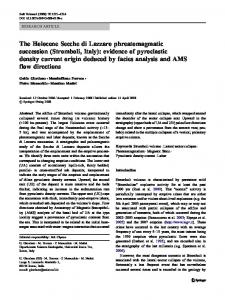
Flowerdew and Green (1989, 1992, 1994) used explanatory variables collected on the target units to improve estimates from areal interpolation. Consider the simple example given by Flowerdew and Green (1989) in which the variable of interest is a count variable observed on n source regions. Of interest is an estimate for the count associated with each of several irregularly shaped target zones, each of which overlaps some of the source units (Fig. 2). Flowerdew and Green called these incompatible zones. A binary covariate is measured on each target zone, and the intensity of the count process is assumed to be either ‹1 or ‹2 , depending on whether the value of the covariate is 1 or 2. Flowerdew and Green (1989) estimated the parameters ‹1 and ‹2 by regressing (using Poisson regression) the count for each source unit, Yi , on A1i and A2i , where A1i is the area of source unit i overlapped by a target unit with a covariate value of 1 and A2i is de ned similarly. The estimated count for any particular subunit formed by division of a source unit by the boundaries of the target units was then taken to be the area of the subunit times the estimated ‹i associated with the covariate value i for that unit. To force the estimates to satisfy the pycnophylactic property, the source zone estimates were scaled by a factor equal to the ratio of the observed value to the tted value. Estimated counts for each target unit were then obtained by adding the estimates of each subunit composing the target unit.
Ai
where W 4¢5 is a speci ed kernel function. Given the weight function, a locally weighted estimate of the underlying density was obtained by maximizing the weighted log-likelihood of the data. For areal data, taking Z4Ai 5 Poisson4Ni ‹5, a locally weighted estimate of ‹ at 4x1 y5 is X X O ‹4x1 y5 D wi 4x1 y5Z4Ai 5=Ni wi 4x1 y50 i
i
Brillinger (1990) extended this approach to include explanatory covariates (using the common Poisson-lognormal model), and Brillinger (1994) used the delta method to obtain an estimate of the uncertainty associated with estimated density surface at each point. Similar ideas have been used to estimate
Figure 2. Incompatible Zones. (Adapted from Flowerdew and Green 1989.)
644
Journal of the American Statistical Association, June 2002
Flowerdew and Green (1992, 1994) extended their earlier work to include several different types of response variables (e.g., binomial, Gaussian) and continuous covariate information. The EM algorithm was used to estimate the necessary parameters, but any software implementing generalized linear model (GLM) methodology may be adapted to this problem. In particular, GLM software that allows the areal data to be spatially correlated (not considered in Flowerdew and Green’s work) might be used to improve the results. If the estimates of ‹1 and ‹2 are substantially different and the relationship between the count variable and the binary covariate is strong, then this approach will be more accurate than the traditional polygonal overlay method. 5.5
Bayesian Areal Regression Models
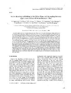
Mugglin and Carlin (1998) extended the work of Flowerdew and Green using a Bayesian approach to areal interpolation. They initially considered the case in which an outcome variable of interest, Y , was measured on i D 11 2 regions (the source units) and prediction of this variable for region 3 (the target unit) was desired. A binary covariate, X, was measured on j subunits, j D 11 : : : Ni , completely nested within both target and source units (Fig. 3). To develop a predictor of Y3 , Mugglin and Carlin (1998) assumed the existence of latent count variables de ned on each subregion. These were assigned independent Poisson distributions with parameters ‹1 or ‹2 , depending on the value of the covariate in the subregion. Then the count in each source zone was considered to be the sum of the counts in the subregions composing the source zone. So, following Flowerdew and Green (1989), Yi — ‹1 1 ‹2
Poisson4‹1 A1i C ‹2 A2i 51
where A1i is the area of region i with a covariate value of 1 and A2i is de ned similarly. But instead of estimating ‹1 and ‹2 using Poisson regression, Mugglin and Carlin (1998) developed a Bayesian hierarchical model. Vague, independent gamma421 605 prior distributions were chosen for ‹1 and ‹2 so that the prior mean corresponded to the expected average count of each subregion, and Metropolis updating was used
Figure 3. The Nested Misalignment Problem. (Adapted from Mugglin and Carlin 1998.)
to sample from the joint posterior distribution and make inferences on ‹1 and ‹2 . Mugglin and Carlin (1998) also recognized that prediction of Y3 (the count in the target zone), not estimation, was the appropriate inferential tool for this problem. In obtaining the predictive distribution of Y3 — Y1 1 Y2 , they showed that the count variables Y3\1 and Y3\2 (delineating the parts of Y3 that also lie in regions 1 and 2) were both binomial variables that could not exceed Y1 and Y2 . This ensured Tobler’s pycnophylactic property. Additional details and supporting theorems were given by Mugglin and Carlin (1998). They then applied these ideas to a more general regression situation based on leukemia counts in Tompkins County, New York. Disease counts were available at the census tract level, and prediction of disease counts at the census block group level was of interest. Demographic factors, including population totals, and distance of the block group centroid from an hazardous waste site, were used as covariates for the predictions. Mugglin, Carlin, Zhu, and Conlon (1999) extended these ideas to smoothing models that allow for spatial heterogeneity and clustering, and Mugglin, Carlin, and Gelfand (2000) considered a more general misalignment problem. This latter work considered two misaligned grids, B and C, that have different spatial supports. The B cells were the source units, and a response variable of interest, Yi , was observed for each Bi . Covariates, Xj , were observed on each target unit Cj . The misalignment of the B’s and C’s prevents the use of standard regression methods for inference on Y . To solve this misalignment problem, Mugglin et al. (2000) developed a Bayesian hierarchical model by conditioning on latent variables associated with smaller areas (called atoms) delineated by the intersection of the two grids. The latent variables were assumed to have conditionally independent Poisson distributions, the means of which were taken to be functions of the areas of each atom and random effects that accounted for grid cell effects. In addition, a spatial Markov random eld prior speci cation was introduced to model the spatial association among the Yi ’s. This latter extension overcame one of the main criticisms of the methods described in Sections 5.3 and 5.4. Although the details of the model building and MCMC implementation are complex, the underlying idea was to build a model at the atom level, thus producing a common grid on which X and Y could be related. Mugglin et al. (2000) illustrated a more general model that included a covariate, W , associated with each B cell, and noted that both X and W could be vectors of covariates and not simply scalars. These perhaps could be used to account for large-scale spatial nonstationarity in the Y process. Also, different distributions for the aggregated count measurements could be used, although the user would need to make the necessary theoretical derivations and confront the implementational issues not addressed by Mugglin et al. (2000). As noted earlier, the main cause of bias in ecological inference is the loss of relevant information on the individuals composing each target and source zone. Flowerdew and Green (1989) and Mugglin and Carlin (1998) recovered some of this information by including relevant covariate information available on some of the source zones. Best, Ickstadt, and Wolpert (2000) considered a slightly different approach using a marked point process that directly allowed the use of individual-level
Gotway and Young: Combining Incompatible Spatial Data
outcomes (disease cases) and covariate information (e.g., race, sex) instead of areal data to make the desired individual-level inferences. They recommended the use of Poisson regression with an idenity link, as opposed to the traditional logarithmic link function, to make the analysis scale independent (i.e., the regression parameter is the same for both individual and areal data) and reduce ecological bias. To solve the problem of incompatible spatial data (disease prevalence data and air pollution measurements from monitors), Best et al. (2000) assigned the case data to the centroid of the postal code of the home address of the case and estimated the air pollution concentration at this centroid from point measurements obtained from air pollution monitors. A Bayesian hierarchical point process model using the Poisson/gamma model developed by Wolpert and Ickstadt (1998) was then used to make inferences about the relationship between disease and pollution at the postal centroids. This is similar to a solution suggested in Section 3.1, although the approach of Best et al. (2000) did not account for locational errors in assigning the cases to the centroids or for uncertainty in the estimated air pollution measurements. These models illustrate the power and exibility of Bayesian hierarchical models in map overlay problems. However, their utility comes from several key assumptions that are largely unveri able from the data. The creation of latent variables de ned on the atoms, together with the prior speci cations and the sampling methods used for inference with MCMC methods, effectively amounts to assumed knowledge of the distributions of both X and Y variables at a common level of support. As with the multiscale tree models described in Section 4.2, implicit assumptions are made about the crosscorrelation between the two variables that are dif cult to verify. The use of proportional allocation in modeling conditional means does not account for the shape of the units needed for complete solutions to COSPs. Future re nements to existing solutions to the spatial misalignment problem may be able to address these issues. 6.
DISCUSSION
This article has presented a comprehensive review of statistical methods for combining incompatible spatial data. The multidisciplinary history provided conveys the complexity of the problems encountered in combining disparate spatial data and the widespread interest in solutions that have been developing over many decades. This is now an active area of statistical research, and many powerful and novel methods have recently been developed. Although the problems that arise in combining incompatible spatial data have been given many different names, they all can be considered COSPs. Spatial support is much more than the area or volume associated with the data; it also includes the shape and orientation of the spatial units being considered. The central issue in COSPs is determination of the relationships between data at various scales or levels of aggregation. A common solution strategy for COSPs is to build a model from point support data or from data with small areal support, (even if no observations are taken at this level of support) and then nd a way to (optimally) estimate important parameters and make valid inference. Of course, it is the latter part
645
of this paradigm that makes viable solutions so dif cult, and some assumptions must be made to obtain any solution. Thus concern shifts to the validity of these assumptions. Traditional geostatistical solutions cleanly delineate complex covariance structures, but then often rely on contrived parametric models to describe them. A hierarchical speci cation circumvents this problem by allowing the scientist to break down a complex problem into more tractable pieces. Are these pieces really more tractable, or are they more tractable only because we are somehow more willing to make simplifying assumptions conditionally, hoping that the structure induced through the various hierarchies will be suf ciently complex to provide a satisfactory model? Ecologists have adopted the approach of trying to explain how variables at one scale change as they go to another scale. Statisticians assume that they have this knowledge either through the choice of parametric covariance models or through a hierarchical speci cation and prior information. Much progress has been made on combining incompatible spatial data, but the assumptions made when doing so often ignore the differing supports. Thus these assumptions are much more than mathematical and computational assumptions, and they can (often surreptitiously) result in unusual or unrealistic cross-scale relationships. Further development of data-driven diagnostic and validation tools will help assess the impact and validity of many of these assumptions. Increasing use of G IS systems makes the COSP relevant and solutions crucial. Substantial progress has been made in the development of valid methods for combining incompatible spatial data, much of it only recently. Hopefully, these methods will be quickly incorporated into an interactive G IS framework that will help ensure that valid statistical methods are used for spatial analysis. [Received September 2000. Revised August 2001.]
REFERENCES Aldworth, J., and Cressie, N. (1999), “Sampling Designs and Prediction Methods for Gaussian Spatial Processes,” in Multivariate Analyses, Design of Experiments, and Survey Sampling, ed. S. Ghosh, New York: Marcel Dekker, pp. 1–54. (2002), “Prediction of Nonlinear Spatial Functionals,” Journal of Statistical Planning and Inference, In Press. Amrhein, C. G., and Flowerdew, R. (1992), “The Effect of Data Aggregation on a Poisson Regression Model of Canadian Migration,” Environment and Planning, Ser. A, 24, 1381–1391. Arbia, G. (1986), “The Modi able Areal Unit Problem and the Spatial Autocorrelation Problem: Towards a Joint Approach,” Metron, 44, 391–407. (1989), “Statistical Effect of Data Transformations: A Proposed General Framework,” in The Accuracy of Spatial Data Bases, eds. M. Goodchild and S. Gopal, London: Taylor and Francis, pp. 249–259. Armstrong, M. (1999), Basic Linear Geostatistics, New York: Springer-Verlag. Basseville, M., Benveniste, A., Chou, K. C., Golden, S. A., Nikoukhah, R., and Willsky, A. S. (1992), “Modeling and Estimation of Multiresolution Stochastic Processes,” IEEE Transactions on Information Theory, 38, 766–784. Batty, M. (1976), “Entropy in Spatial Aggregation,” Geographical Analysis, 8, 1–21. Bell, G., Lechowitz, M. J., Appenzeller, A., Chandler, M., DeBlois, E., Jackson, L., Mackenzie, B., Preziosi, R., Scallenberg, M., and Tinker, N. (1993), “The Spatial Structure of the Physical Environment,” Oecologia, 96, 114–121. Bellehumeur, C., and Legendre, P. (1998), “Multiscale Sources of Variation in Ecological Variables: Modeling Spatial Dispersion, Elaborating Sampling Designs,” Landscape Ecology, 13, 15–25. Berliner, L. M., Royle, J. A., Wikle, C. K., and Milliff, R. F. (1999), “Bayesian Methods in Atmospheric Sciences” (with discussion), in Bayesian Statistics 6, eds. J. M. Bernardo, J. O. Berger, A. P. Dawid, and A. F. M. Smith, New York: Oxford University Press, pp. 83–100.
646 Best, N. G., Ickstadt, K., and Wolpert, R. L. (2000), “Spatial Poisson Regression for Health and Exposure Data Measured at Disparate Resolutions,” Journal of the American Statistical Association, 95, 1076–1088. Bian, L., and Butler, R. (1999), “Comparing Effects of Aggregation Methods on Statistical and Spatial Properties of Simulated Spatial Data,” Photogrammetric Engineering & Remote Sensing, 65, 73–84. Bissonette, J. A. (1997), “Scale-Sensitive Ecological Properties: Historical Context, Current Meaning,” in Wildlife and Lanscape Ecology: Effects of Pattern and Scale, ed. J. A. Bissonette, New York: Springer-Verlag, pp. 3–31. Blalock, H. M. (1964), Causal Inferences in Nonexperimental Research, Chapel Hill, NC: University of North Carolina Press. Bonham-Carter, G. F. (1994), Geographic Information Systems for Geoscientists, New York: Pergamon Press/Elsevier Science. Bonham-Carter, G. F., Agterberg, F. P., and Wright, D. F. (1988), “ Integration of Geological Datasets for Gold Exploration in Nova Scotia,” Photogrammetric Engineering & Remote Sensing, 54, 1585–1592. Brillinger, D. R. (1990), “Spatial-Temporal Modeling of Spatially Aggregate Birth Data,” Survey Methodology, 16, 255–269. (1994), “Examples of Scienti c Problems and Data Analyses in Demography, Neurophysiology, and Seismology,” Journal of Computational and Graphical Statistics, 3, 1–22. Brown, R. G. (1983), Random Signal Analysis and Kalman Filtering (rev. ed.), New York: Wiley. Carroll, S. S., Day, G. N., Cressie, N., and Carroll, T. R. (1995), “Spatial Modeling of Snow Water Equivalent Using Airborne and Ground-Based Snow Data,” Environmetrics, 6, 127–139. Chiles, J. P., and Del ner, P. (1999), Geostatistics: Modeling Spatial Uncertainty, New York: Wiley. Chou, K. C., Willsky, A. S., and Nikoukhah, R. (1994), “Multiscale Systems, Kalman Filters, and Riccati Equations,” IEEE Transactions on Automatic Control, 39, 479–492. Chung, C.-J. F., and Fabbri, A. G. (1999), “Probabilistic Prediction Models for Landslide Hazard Mapping,” Photogrammetric Engineering & Remote Sensing, 65, 1389–1400. Clark, I. (1979), Practical Geostatistics, Essex, U.K.: Applied Science. Clark, I., Basinger, K. L., and Harper, W. V. (1989), “MUCK: A Novel Approach to Cokriging,” in Proceedings of the Conference on Geostatistical, Sensitivity, and Uncertainty Methods for Ground-Water Flow and Radionuclide Transport Modeling, ed. B. Buxton, Columbus, OH: Battelle Press, pp. 473–493. Clark, W. A. V., and Avery, K. L. (1976), “The Effects of Data Aggregation in Statistical Analysis,” Geographical Analysis, 8, 428–438. Cleave, N., Brown, P. J., and Payne, C. D. (1995), “Evaluation of Methods for Ecological Inference,” Journal of the Royal Statistical Society, Ser. B, 159, 55–72. Cramer, J. S. (1964), “Ef cient Grouping, Regression and Correlation in Engel Curve Analysis,” Journal of the American Statistical Association, 59, 233–250. Cressie, N. (1993a), “Aggregation in Geostatistical Problems,” in Geostatistics Troia ’92, ed. A. Soares, Dordrecht: Kluwer Academic, pp. 25–35. (1993b), Statistics for Spatial Data, New York: Wiley. (1996), “Change of Support and the Modi able Areal Unit Problem,” Geographical Systems, 3, 159–180. (1998), “Aggregation and Interaction Issues in Statistical Modeling of Spatiotemporal Processes,” Geoderma, 85, 133–140. Cressie, N., and Wikle, C. K. (1998), “The Variance-Based Cross-Variogram: You Can Add Apples and Oranges,” Mathematical Geology, 30, 789–799. Daley, R. (1991), “Atmospheric Data Analysis,” Cambridge, U.K.: Cambridge University Press. (1992), “Estimating Model-Error Covariances for Application to Atmospheric Data Assimilation,” Monthly Weather Review, 120, 1735–1746. Diggle, P. J., Tawn, J. A., and Moyeed, R. A. (1998), “Model-Based Geostatistics” (with discussion), Applied Statistics, 47, 299–350. Dyn, N., Wahba, G., and Wong, W.-H. (1979), discussion of “Smooth Pycnophylactic Interpolation for Geographical Regions” by W. Tobler, Journal of the American Statistical Association, 74, 530–535. Emerson, C. W., Lam, N. S.-N., and Quattrochi, D. A. (1999), “Multi-Scale Fractal Analysis of Image Texture and Pattern,” Photogrammetric Engineering & Remote Sensing, 65, 51–61. Fair eld Smith, H. (1938), “An Empirical Law Describing Heterogeneity in the Yields of Agricultural Crops,” Journal of Agricultural Science, 28, 1–23. Fieguth, P. W., Karl, W. C., Willsky, A. S., and Wunsch, C. (1995), “Multiresolution Optimal Interpolation and Statistical Analysis of TOPEX/POSE IDON Satellite Altimetry,” IEEE Transactions on Geoscience and Remote Sensing, 33, 280–292.
Journal of the American Statistical Association, June 2002 Firebaugh, G. (1978), “A Rule for Inferring Individual-Level Relationships From Aggregate Data,” American Sociological Review, 43, 557–572. Flowerdew, R., and Green, M. (1989), “Statistical Methods for Inference Between Incompatible Zonal Systems,” in The Accuracy of Spatial Data Bases, eds. M. Goodchild and S. Gopal, London: Taylor and Francis, pp. 239–247. (1992), “Developments in Areal Interpolating Methods and G IS,” Annals of Regional Science, 26, 67–78. (1994), “Areal Interpolation and Types of Data,” in Spatial Analysis and G IS, eds. S. Fotheringham and P. Rogerson, London: Taylor and Francis, pp. 121–145. Fotheringham, A. S. (1989), “Scale- Independent Spatial Analysis,” in The Accuracy of Spatial Data Bases, eds. M. Goodchild and S. Gopal, London: Taylor and Francis, pp. 221–228. Fotheringham, A. S., and Wong, D. W. S. (1991), “The Modi able Areal Unit Problem in Multivariate Statistical Analysis,” Environment and Planning, Ser. A, 23, 1025–1044. Gabrosek, J., Huang, H.-C., and Cressie, N. (1999), “Spatio-Temporal Prediction of Level 3 Data for NASA’s Earth Observing System,” in Spatial Accuracy Assessment: Land Information Uncertainty in Natural Resources, eds. K. Lowell and A. Jaton, Chelsea, M I: Ann Arbor Press. Gaudard, M., Karson, M., Linder, E., and Sinha, D. (1999), “Bayesian Spatial Prediction,” Environmental and Ecological Statistics, 6, 147–171. Gehlke, C. E., and Biehl, K. (1934), “Certain Effects of Grouping Upon the Size of the Correlation Coef cient in Census Tract Material,” Journal of the American Statistical Association, supp 29, 169–170. Gelfand, A. E., Zhu, L., and Carlin, B. P. (2001), “On the Change of Support Problem for Spatio-Temporal Data,” Biostatistics, 2, 31–45. Ghil, M., Cohn, S., Tavantzia, J., Bube, K., and Isaacson, E. (1981), “Applications of Estimation Theory to Numerical Prediction Assimilation,” in Dynamic Meteorology: Data Assimilation Methods, eds. L. Bengtsson, M. Ghiul, and E. Kallen, London: Springer-Verlag, pp. 139–224. Goldstein, H. (1995), “Multilevel Statistical Models,” (2nd ed.), Kendall’s Library of Statistics Vol. 3, London: Edward Arnold. Goodchild, M. F., and Lam, N. S.-N. (1980), “Areal Interpolation: A Variant of the Traditional Spatial Problem,” Geo-Processing, 1, 297–312. Goodman, L. A. (1959), “Some Alternatives to Ecological Correlation,” American Journal of Sociology, 64, 610–625. Goovaerts, P. (1997), Geostatistics for Natural Resources Evaluation, New York: Oxford University Press. (1998), “Geostatistical Tools for Characterizing the Spatial Variability of Microbiological and Physico-Chemical Soil Properties,” Biology and Fertility of Soils, 27, 315–334. Greenland, S., and Morganstern, H. (1989), “Ecological Bias, Confounding, and Effect Modi cation,” International Journal of Epidemiology, 18, 269–274. Greenland, S., and Robins, J. (1994), “Ecologic Studies—Biases, Misconceptions, and Counterexamples,” American Journal of Epidemiology, 139, 747–760. Greig-Smith, P. (1952), “The Use of Random and Contiguous Quadrats in the Study of Structure in Plant Communities,” Annals of Botany, New Series, 16, 293–316. Haitovsky, Y. (1984), Regression Estimation From Grouped Observations, New York: Harner Press. Handcock, M. G., and Stein, M. L. (1993), “A Bayesian Analysis of Kriging,” Technometrics, 35, 403–410. Hannan, M. T. (1971), Aggregation and Disaggregation in Sociology, Lexington, MA: D.C. Heath. Huang, H.-C., and Cressie, N. (2000), “Multiscale Graphical Modeling in Space: Applications to Command and Control,” in Proceedings of the Spatial Statistics Workshop, ed. M. Moore, New York: Springer-Verlag, pp. —. Huang, H.-C., Cressie, N., and Gabrosek, J. (2000), “Fast ResolutionConsistent Spatial Prediction of Global Processes From Satellite Data,” Technical Report C-2000-2, Institute of Statistical Science, Academia Sinica, available at http://www.stat.sinica.edu.tw/hchuang/paper.html. Isaaks, E. H., and Srivastava, R. M. (1989), An Introduction to Applied Geostatistics, New York: Oxford University Press. Jelinski, D. E., and Wu, J. (1996), “The Modi able Areal Unit Problem and Implications for Landscape Ecology,” Landscape Ecology, 11, 129–140. Johnson, G. D., and Patil, G. P. (1998), “Quantitative Multiresolution Characterization of Landscape Patterns for Assessing the Status of Ecosystem Health in Watershed Management Areas,” Ecosystem Health, 4, 177–187. Journel, A. G. (1983), “Nonparametric Estimation of Spatial Distributions,” Journal of the International Association for Mathematical Geology, 15, 445–468. Journel, A. G., and Huijbregts, C. J. (1978), Mining Geostatistics, London: Academic Press.
Gotway and Young: Combining Incompatible Spatial Data King, G. (1997), A Solution to the Ecological Inference Problem, Princeton, NJ: Princeton University Press. Kitanidis, P. K. (1986), “Parameter Uncertainty in Estimation of Spatial Functions: Bayesian Analysis,” Water Resources Research, 22, 499–507. Klein, S. P., and Freedman, D. A. (1993), “Ecological Regression in Voting Rights Cases,” Chance, 6, 38–43. Krige, D. G. (1951), “A Statistical Approach to Some Basic Mine Valuation Problems on the Witwatersrand,” Journal of Chemical, Metallurgical, and Mining Society of South Africa, 52, 119–139. Le, N. D., and Zidek, J. V. (1992), “ Interpolation With Uncertain Spatial Covariances: A Bayesian Alternative to Kriging,” Journal of Multivariate Analysis, 43, 351–374. Legendre, P., and Fortin, M. (1989), “Spatial Pattern and Ecological Analysis,” Vegetation, 80, 107–138. Levin, S. A. (1992), “The Problem of Pattern and Scale in Ecology,” Ecology, 73, 1943–1967. Littell, R. C., Milliken, G. A., Stroup, W. W., and Wol nger, R. D. (1996), The SAS System for Linear Models, Cary, NC: SAS Institute. Markoff, J., and Shapiro, G. (1973), “The Linkage of Data Describing Overlapping Geographical Units,” Historical Methods Newsletter, 7, 34–46. Matheron, G. (1963), “Principles of Geostatistics,” Economic Geology, 58, 1246–1266. (1984), “ Isofactorial Models and Change of Support,” in Geostatistics for Natural Resources Characterization, eds. G. Verly, M. David, A. Journel, and A. Marechal, Dordrecht: Reidel, pp. 449–467. May, R. M. (1994), “The Effects of Spatial Scale on Ecological Questions and Answers,” in Large-Scale Ecology and Conservation Biology (35th Symposium of the British Ecological Society of Conservation Biology), eds. P. Edwards, R. May, and N. Webb, London: Blackwell Scienti c, pp. 1–17. McNeill, L. (1991), “ Interpolation and Smoothing of Binomial Data for the Southern African Bird Atlas Project,” South African Journal of Statistics, 25, 129–136. Meinhold, J., and Singpurwalla, N. D. (1983), “Understanding the Kalman Filter,” The American Statistician, 37, 123–127. Milne, B. T. (1988), “Measuring the Fractal Dimension of Landscapes,” Applied Mathematical Computing, 27, 67–79. Moellering, H., and Tobler, W. (1972), “Geographical variances,” Geographical Analysis, 4, 34–50. Morganstern, H. (1982), “Uses of Ecologic Analysis in Epidemiologic Research,” American Journal of Public Health, 72, 1336–1344. Mugglin, A. S., and Carlin, B. P. (1998), “Hierarchical Modeling in Geographic Information Systems: Population Interpolation Over Incompatible Zones,” Journal of Agricultural, Biological, and Environmental Statistics, 3, 117–130. Mugglin, A. S., Carlin, B. P., and Gelfand, A. E. (2000), “Fully Model-Based Approaches for Spatially Misaligned Data,” Journal of the American Statistical Association, 95, 877–887. Mugglin, A. S., Carlin, B. P., Zhu, L., and Conlon, E. (1999), “Bayesian Areal Interpolation, Estimation, and Smoothing: An Inferential Approach for Geographic Information Systems,” Environment and Planning, Ser. A, 31, 1337–1352. Müller, H.-G., Stadtmüller, U., and Tabnak, F. (1997), “Spatial Smoothing of Geographically Aggregated Data, With Application to the Construction of Incidence Maps,” Journal of the American Statistical Association, 92, 61–71. Myers, D. E. (1984), “Cokriging—New Developments,” in Geostatistics for Natural Resources Characterization, eds. G. Verly, M. David, A. G. Journel, and A. Marechal, Dordrecht: Reidel, pp. 295–305. (1991), “Pseudo–Cross-Variograms, Positive De niteness, and Cokriging,” Mathematical Geology, 23, 805–816. Nielsen, D. R., Wendroth, O., and Parlange, M. B. (1995), “Opportunities for Examining On-Farm Soil Variability,” in Site-Speci c Management for Agricultural Systems, eds. P. Robert, R. H. Rust, and W. E. Larson, Madison, W I: American Society of Agronomy, pp. 95–132. O’Hagan, A. (1994), Bayesian Inference, London: Edward Arnold. Olea, R. A. (1991), Geostatistical Glossary and Multilingual Dictionary, New York: Oxford University Press. Oliver, M. A., Lajaunie, C., Webster, R., Muir, K. R., and Mann, J. R. (1993), “Estimating the Risk of Childhood Cancer,” in Geostatistics Troia ’92, ed. A. Soares, Dordrecht: Kluwer Academic Publishers, pp. 899–910. Oliver, M. A., and Webster, R. (1986), “Combining Nested and Linear Sampling for Determining the Scale and Form of Spatial Variation of Regionalized Variables,” Geographical Analysis, 18, 227–242. Openshaw, S. (1984), The Modiable Areal Unit Problem, Norwich, U.K.: Geobooks. Openshaw, S., and Taylor, P. (1979), “A Million or so Correlation Coef cients,” in Statistical Methods in the Spatial Sciences, ed. N. Wrigley, London: Pion, pp. 127–144.
647 (1981), “The Modi able Areal Unit Problem,” in Quantitative Geography: A British View, eds. N. Wrigley and R. Bennett, London: Routledge & Kegan Paul, pp. 60–69. Palmer, M. W. (1988), “Fractal Geometry: A Tool for Describing Spatial Patterns of Plant Communities,” Vegetation, 75, 91–102. Papritz, A., Kunsch, H. R., and Webster, R. (1993), “On the Pseudo-CrossVariogram,” Mathematical Geology, 25, 1015–1026. Patil, G. P., and Taillie, C. (1999), “Quantitative Characterization of Hierarchically Scaled Landscape Patterns,” in Proceedings of the 25th Biennial Meeting of the International Statistical Institute, Vol. 58, Helsinki: Statistics Finland, pp. 89–92. Phipps, M. (1991), “Entropy and Community Pattern Analysis,” Journal of Theoretical Biology, 93, 253–273. Piantadosi, S., Byar, D. P., and Green, S. B. (1988), “The Ecological Fallacy,” American Journal of Epidemiology, 127, 893–904. Prais, S. J., and Aitchison, J. (1954), “The Grouping of Observations in Regression Analysis,” Revue de l’ Institut International de Statistique, 1, 1–22. Putnam, S. H., and Chung, S.-H. (1989), “Effects of Spatial System on Spatial Interaction Models. 1: The Spatial System De nition Problem,” Environment and Planning, Ser. A, 21, 27–46. Raines, G. L., Bonham-Carter, G. F., and Kemp, L. (2000), “Predictive Probabilistic Modeling Using ArcView G IS,” ArcUser, April-June, 46–48. Renshaw, E., and Ford, E. D. (1984), “The Description of Spatial Pattern Using Two-Dimensional Spectral Analysis,” Vegetation, 56, 75–85. Richardson, S. (1992), “Statistical Methods for Geographical Correlation Studies,” in Geographical and Environmental Epidemiology: Methods for Small Area Studies, eds. P. Elliott, J. Cuzick, D. English, and R. Stern, New York: Oxford University Press, pp. 181–204. Richardson, S., Stucker, I., and Hemon, D. (1987), “Comparison of Relative Risks Obtained in Ecological and Individual Studies: Some Methodological Considerations,” International Journal of Epidemiology, 16, 111–120. Rivoirard, J. (1994), Introduction to Disjunctive Kriging and Nonlinear Geostatistics, Oxford, U.K.: Clarendon Press. Robinson, A. H. (1956), “The Necessity of Weighting Values in Correlation Analysis of Areal Data,” Annals of the Association of American Geographers, 46, 233–236. Robinson, W. S. (1950), “Ecological Correlations and the Behavior of Individuals,” American Sociological Review, 15, 351–357. Royle, J. A., Berliner, L. M., Wikle, C. K., and Milliff, R. (1997), “A Hierarchical Spatial Model for Constructing Wind Fields From Scatterometer Data in the Labrador Sea,” Technical Report 97-30, Ohio State University. Selvin, H. C. (1958), “Durkheim’s ‘Suicide’ and Problems of Empirical Research,” American Journal of Sociology, 63, 607–619. Steel, D. G., and Holt, D. (1996), “Analyzing and Adjusting Aggregation Effects: The Ecological Fallacy Revisited,” International Statistical Review, 64, 39–60. Sugihara, G., and May, R. M. (1990), “Application of Fractals in Ecology,” Trends in Ecology and Evolution, 5, 79–86. Theil, H. (1972), Econometrics and Information Theory, Amsterdam: NorthHolland. Thiessen, A. H. (1911), “Precipitation for Large Areas,” Monthly Weather Review, 39, 1082–1084. Thomas, E. N., and Anderson, D. L. (1965), “Additional Comments on Weighting Values in Correlation Analysis of Areal Data,” Annals of the Association of American Geographers, 55, 492–505. Tobler, W. (1979), “Smooth Pycnophylactic Interpolation for Geographical Regions” (with discussion), Journal of the American Statistical Association, 74, 519–536. (1989), “Frame Independent Spatial Analysis,” in The Accuracy of Spatial Data Bases, eds. M. Goodchild and S. Gopal, London: Taylor and Francis, pp. 115–122. Turner, M. G., Dale, V. H., and Gardner, R. H. (1989), “Predicting Across Scales: Theory Development and Testing,” Landscape Ecology, 3, 245–252. Turner, M. G., O’Neill, R. V., Gardner, R. H., and Milne, B. T. (1989), “Effects of Changing Spatial Scale on the Analysis of Landscape Pattern,” Landscape Ecology, 3, 153–162. Ver Hoef, J. M., and Barry, R. M. (1998), “Constructing and Fitting Models for Cokriging and Multivariate Spatial Prediction,” Journal of Statistical Planning and Inference, 69, 275–294. Ver Hoef, J. M., and Cressie, N. (1993), “Spatial Statistics: Analysis of Field Experiments,” in Design and Analysis of Ecological Experiments, eds. S. M. Scheiner and J. Gurevitch, New York: Chapman and Hall, pp. 319–341. Ver Hoef, J. M., Cressie, N. A. C., and Glenn-Lewin, D. C. (1993), “Spatial Models for Spatial Statistics: Some Uni cation,” Journal of Vegetation Science, 4, 441–452.
648 Verly, G. (1983), “The Multi-Gaussian Approach and Its Applications to the Estimation of Local Reserves,” Journal of the International Association for Mathematical Geology, 15, 259–286. Wackernagel, H. (1995), “Multivariate Geostatistics—An Introduction With Applications, Berlin: Springer Verlag. Walter, S. D. (1991), “The Ecologic Method in the Study of Environmental Health II: Methodologic Issues and Feasibility,” Environmental Health Perspectives, 94, 67–73. Webster, R., Oliver, M. A., Muir, K. R., and Mann, J. R. (1994), “Kriging the Local Risk of a Rare Disease From a Register of Diagnoses,” Geographical Analysis, 26, 168–185. Wikle, C. K., Berliner, L. M., and Cressie, N. (1998), “Hierarchical Bayesian Space-Time Models,” Environmental and Ecological Statistics, 5, 117–154. Wikle, C. K., Milliff, R. F., Nychka, D., and Berliner, L. M. (2001), “Spatio-
Journal of the American Statistical Association, June 2002 Temporal Hierarchical Bayesian Modeling: Tropical Ocean Surface Winds,” Journal of the American Statistical Association, 96, 382–397. Williams, I. N. (1976), “Optimistic Theory Validation From Spatially Grouped Regression,” Transactions of the Martin Centre for Architectural and Urban Studies, 1, 113–145. Wolpert, R. L., and Ickstadt, K. (1998), “Poisson/Gamma Random Field Models for Spatial Statistics,” Biometrika, 85, 251–267. Wong, D. W. S. (1996), “Aggregation Effects in Geo-Referenced Data,” in Advanced Spatial Statistics, ed. D. Grif ths, Boca Raton, FL: CRC Press, pp. 83–106. Woodcock, C. E., and Strahler, A. H. (1987), “The Factor of Scale in Remote Sensing,” Remote Sensing and the Environment, 21, 311–332. Yule, G. U., and Kendall, M. G. (1950), An Introduction to the Theory of Statistics (14th ed.), London: Grif n.