Developing Methods for Converting Digitised Rivers into a Hydrological Drainage Network
Report to the WATER RESEARCH COMMISSION by HL Weepener1, JJ le Roux2, EC van den Berg1, DR Tswai1 and JP Nell1 1
2
ARC – Institute for Soil, Climate and Water Department of Geography, University of the Free State
WRC Report No. 2164/1/15 ISBN 978-1-4312-0666-7 April 2015
Obtainable from Water Research Commission Private Bag X03 GEZINA, 0031
[email protected] or download from www.wrc.org.za
DISCLAIMER This report has been reviewed by the Water Research Commission (WRC) and approved for publication. Approval does not signify that the contents necessarily reflect the views and policies of the WRC, nor does mention of trade names or commercial products constitute endorsement or recommendation for use.
© Water Research Commission ii
EXECUTIVE SUMMARY Background In this study techniques were investigated to create a South African river network that is repeatable and applicable to all the water catchments in South Africa. The methodology was implemented on two selected catchments and aimed to produce a network that will contain rivers similar to the 1:250 000 scale topographic maps at an accuracy that is equivalent to the 1:50 000 scale. Spatial databases of drainage networks are invaluable in many fields, for example spatial analysis and hydrological modelling. River lines in a hydrological network must be seamlessly connected and must have flow direction. Hydrological modelling is an essential component of water resource management and the importance of river network databases is evident in the extensive efforts that have been undertaken to date in attempting to develop standard river network datasets for South Africa. These efforts date back to the 1990s when the Department of Water Affairs started projects to produce improved river lines for use in GIS modelling from the country’s 1:50 000 topographic maps. Resource Quality Services (RQS) and the Directorate of Spatial and Land Information Management worked on river networks visible on the 1:500 000 scale and the 1:50 000 scale topographic maps, respectively. The aforementioned 1:500 000 spatial dataset was completed after 10 years while the latter is still in process. The Department of Rural Development and Land Reform – Chief Directorate: National Geospatial Information (NGI) is responsible for the 1:50 000 topographic maps (including river lines). The focus of these datasets is on the geographic representation of the data. Their utility remains and continues to be substantially constrained by numerous inconsistencies and inaccuracies imparted by compilation from aerial photographs. The major inaccuracies include: a) some gaps between tributaries and main streams, b) isolated and incomplete river lines, c) inconsistency in density of river coverage between map sheets and d) numerous instances in which lines do not point downstream. River networks are not only important for hydrology, but also many other disciplines such as anthropology, ecosystems, groundwater recharge, epidemiology and geomorphology. An example where a South African hydrological network has been useful outside the hydrological domain is the epidemiological study of cholera in the Thukela by Bertuzze et al. (2008) who made use of the RQS 1:500 000 river network.
Aim and Objectives The aim was to develop a semi-automated methodology for creating a robust, country wide, accurate river network coverage for use in GIS projects and other planning initiatives in South Africa. This was achieved by applying the following objectives in two selected catchments: •
Creation of river networks through improvement of 1:50 000 river lines from NGI. River lines should be seamlessly connected, contain flow direction and attributes such as stream order and perennial status. iii
• •
•
Adopting suitable modelling approach to select river lines from SRTM flow paths for trans-boundary catchment areas. Mapping of vegetation from remote sensing data, as supportive information in arid environments, such as the D42 study site, where trees are sometimes confined to the banks of ephemeral rivers. Mapping of open water bodies from remote sensing imagery as supportive information in identifying river lines and perennial status of river.
Methodology The methodology was applied to a portion of the Molopo catchment (Tertiary catchment D42) in the Northern Cape Province and the Mzimvubu catchment (Secondary catchment T3) in the Eastern Cape Province. The Molopo catchment falls in a low rainfall regime area with a groundwater mean annual recharge of only 0.1-5 mm and is located on the border of South Africa, Botswana and Namibia. The area is drained by the Nossob, Auob and Molopo rivers and is 250 000 km2 in size of which 57 000 km2 (23%) is within the borders of South Africa. The Mzimvubu River catchment is classified as a primary catchment and falls in a sub-humid climate with a groundwater mean annual recharge of 12-70 mm. It has a drainage area of 19 826 km2 and a flow length of approximately 350 km from north to south. Developing of the river editing tool The River Editing tool developed for this project simplifies the editing of both line features and attribute data. Amongst others it has the following functionality: • • • • • •
Automatically applying flow direction of stream lines from a DEM. Automatically applying flow direction from the mouth of a river network. Finding loops in the river network. Selecting upstream or downstream line segments from a specified position. Assigning attributes to all selected stream lines. Calculating stream order of river segments in a river network.
The River Editing tool was used to calculate stream order values for four different stream order types (Strahler, Horton, Shreve and Hack). During the calculation of the stream orders the distance of the longest upstream path in the river network was also calculated and stored. Remote sensing imagery and derived products used to improve the river centre lines Remote sensing imagery was useful in correcting errors in the river centre line data and also to identify the perennial status of streams. The following products were used as backdrop during manual editing of the data: • • • • • •
NGI colour aerial photography: Molopo and Mzimvubu catchments. SPOT 5 imagery (2005-2011): Molopo and Mzimvubu catchments. Landsat 8 imagery (2000, 2014): Molopo catchment (trans-boundary area). Water classification (NDWI) from SPOT 5 imagery: Mzimvubu catchment. Unsupervised classification of water from SPOT 5 imagery: Mzimvubu catchment. Vegetation classification: Molopo catchment. iv
Extraction of river networks from SRTM flow paths The river centre lines of NGI are only available for South Africa. Flow paths were therefore calculated from the hydrologically improved DEM for cross-border areas of the Molopo catchment. A threshold of 100 was used to indicate the start of flow paths from a flow accumulation grid. River networks were selected from flow paths, taking into consideration homogeneous areas with respect to drainage density (DD) and environmental variables such as precipitation, landcover, soils and terrain. This task was based on the conjunctive use of digital elevation data and environmental parameters in a grid-based GIS. The landscape was manually stratified into drainage density classes. Two parameters that showed a high correlation with DD were the Arenosols soil group and mountainous areas. Particular characteristics of Arenosols are low reserves of weatherable minerals and low silt:clay ratios. The mountainous areas were derived from the SRTM DEM. They had a high DD while Arenosols had a low DD. All areas were ranked according to rainfall and vegetation with sparser vegetation and higher rainfall areas resulting in higher DD.
Conclusion and recommendations River networks were successfully developed for the Molopo and Mzimvubu catchments. This was achieved through the following: • Development of river editing tool • Calculation of flow paths from a DEM • Extraction of river networks from SRTM flow paths • Derivation of supporting information from imagery The networks were in sharp contrast to each other, mainly due to the huge difference in rainfall and steepness of terrain. The Mzimvubu catchment has a well-defined river network with a high DD, while the river network of the Molopo catchment is intermittent with a low DD. The Molopo catchment had numerous small river networks, which were not connected to the main stem, but ended in pans. The perennial status of streams in the Mzimvubu river was either perennial or non-perennial, while the streams in the Molopo could be ephemeral or non-perennial. The four different stream order types that were calculated make it possible to do subsets of the river network. For example, it was illustrated that it is possible to select stream lines at the same level of detail that are displayed on the 1:250 000 maps from the 1:50 000 dataset. The calculation of stream order took a considerable amount of time. For example, for the complete secondary catchment T3 (122 423 line features) it took 161 hours, while tertiary catchments T31 (15 705 features) and T34 (25 233 features) took 4 and 10 hours to complete, respectively. A product was developed indicating the number of times that surface water was classified from the SPOT 5 mosaics for the period 2005-2011. By applying some level of interpretation the following information can be derived from this dataset: • • •
Perennial status of large rivers Area covered by dams Selecting the most significant branch in braided systems v
For the Molopo catchment it was not possible to classify open water, due to the fact that the river beds were mostly dry. A classification of vegetation was done instead and was included as one of the layers used as backdrop during the editing of stream lines. Riparian vegetation often indicated the actual position of streams, when it was unclear on the colour image itself. The River Editing tool was successfully tested on a large dataset such as the Mzimvubu River network (124 528 line segments). The River Editing tool was found to be very useful during the editing of the data to develop river networks. Some of the functions take some time to execute, but it is significantly faster than manual editing. A large improvement from previous versions of the river line data is that most streams have recently been connected by NGI. Remote sensing imagery was useful in correcting errors in the river centre line data and also to identify the perennial status of streams from derived products. NGI must be informed of corrections that were done so that the corrections can also be made on the master dataset hosted by them and incorporated in future. The following follow-up studies are proposed: •
• •
River networks should be developed for the whole country from the NGI dataset. This has to be considered the master dataset and any improvements should be returned to NGI. Since NGI is continuously improving their data the process of developing river networks for all catchments in SA has to be repeated at regular intervals (perhaps every 10 years). A dataset of mountains should be developed for SA. Currently such a dataset does not seem to be readily available. Two studies that could be done for the Molopo catchment specifically are: o Lineament analysis based on different satellite data could contribute to the detection of near-surface fault and fracture zones with potential influence on dissolution processes in sub-terrain waterways. o The patterns and surface alignments of karst (CaCO3) features are often associated with joint patterns, faulting and folding. Channels in karst groundwater are formed from rock dissolution along planes or discontinuities. Therefore, the relationship between the occurrence of depressions, karst development and the tectonic pattern could be investigated by using remote sensing and GIS.
vi
Capacity building The research studies of two members of the project team benefited from this project. Harold Weepener is studying for a PhD degree at the Geography and Environmental Studies Department of the University of Stellenbosch. His thesis is titled: "Application of earth observations and geographical information systems for water resource database development". Simone Pretorius is registered at the University of Pretoria to conduct her MSc at the Centre for Environmental Studies at the Faculty of Natural and Agricultural Sciences. Her research project is titled: “Sediment Yield Modelling of the Tsitsa River Catchment” Institutional capacity building included the Agricultural Research Council, Department of Water Affairs and National Geo-spatial Information. The Mzimvubu River network was also used as a key dataset in another WRC-funded project entitled “Sediment yield modelling in the Mzimvubu river catchment” (K5-22431).
vii
ACKNOWLEDGEMENTS Sincere appreciation for assistance during the project is extended to the following organizations and individuals: The Water Research Commission for funding. The steering committee for significant inputs to the conceptual development of the project, assistance and constructive discussions during the duration of the project, and the finalization of the content of this report. The Steering Committee responsible for this project consisted of the following persons:
Name
Organization
Mr W Nomquphu
Water Research Commission
Dr A Thomas
Council for Geoscience
Mr Raoul Duesimi
National Geo-spatial Information
Dr M Silberbauer
Department Water and Sanitation
Ms C Rajah
Department Water and Sanitation
Mr P Rademeyer
Department Water and Sanitation
Mr D van der Spuy
Department Water and Sanitation
Ms H van Deventer
CSIR
The following personnel from the ARC-ISCW: Philip Beukes and Zibusiso Ncube for assistance in GIS tasks and in the programming of the River Editing Tool. Simone Pretorius for assistance in GIS tasks. Corrie Swanepoel for her insightful advice.
viii
TABLE OF CONTENTS EXECUTIVE SUMMARY ....................................................................................... III ACKNOWLEDGEMENTS................................................................................... VIII TABLE OF CONTENTS........................................................................................ IX LIST OF FIGURES ............................................................................................... XI LIST OF TABLES................................................................................................ XIII LIST OF ABBREVIATIONS ................................................................................ XIV GLOSSARY ........................................................................................................ XVI 1 INTRODUCTION ......................................................................................... 1 1.1 1.2 1.3 1.4
2
DESCRIPTION OF STUDY AREAS AND BASELINE DATASETS. .......... 5 2.1 2.2 2.3
2.4
3
Background and importance ................................................................... 1 Aim and Objectives ................................................................................. 2 Research approach ................................................................................. 3 The structure of the report ....................................................................... 5 Molopo catchment ................................................................................... 5 The Mzimvubu River Catchment ............................................................. 9 National datasets ................................................................................... 11 2.3.1 SPOT 5 imagery ........................................................................ 11 2.3.2 NGI aerial photography.............................................................. 12 2.3.3 River centre lines ....................................................................... 13 2.3.4 Gauging station data.................................................................. 14 Regional datasets .................................................................................. 14 2.4.1 Landsat 8 imagery ..................................................................... 15 2.4.2 Hydrologically improved DEM.................................................... 15 2.4.3 Dominant major soil group in the SOTER (FAO, 1995) data ..... 16 2.4.4 Land Cover ........................................................................... 17 2.4.5 Climate surfaces ........................................................................ 18
METHODOLOGY ...................................................................................... 18 3.1
3.2 3.3 3.4
3.5
Development of river editing tool ........................................................... 18 3.1.1 Repairing geometry errors ......................................................... 19 3.1.2 Removal of loops ....................................................................... 19 3.1.3 Snapping of lines that are not connected .................................. 21 3.1.4 Errors identified in data .............................................................. 21 3.1.5 Set flow direction ....................................................................... 22 3.1.6 Calculate stream order .............................................................. 22 Calculation of flow paths from a DEM ................................................... 24 Extraction of river networks from SRTM flow paths............................... 24 Image processing .................................................................................. 24 3.4.1 Image pre-processing ................................................................ 25 3.4.2 Pixel based classification ........................................................... 25 3.4.3 Object-based image analyses ................................................... 26 3.4.4 Texture analysis......................................................................... 27 3.4.5 Spectral Indices ......................................................................... 27 Classification of water ........................................................................... 29 ix
3.5.1
3.6
3.7
Using ArcScan, an extension of ArcMap, to delineate stream lines.............................................................................. 30 3.5.2 Use flow paths derived from a DEM to separate rivers from noise and other water bodies that were classified as water ........................................................................................ 32 3.5.3 Object based classification of rivers .......................................... 33 Mzimvubu catchment ............................................................................ 35 3.6.1 Cleaning of spatial data in the Mzimvubu catchment ................ 35 3.6.2 Use of remote sensing data and derived products to improve the spatial data in the Mzimvubu catchment .............. 35 3.6.3 Cleaning of attribute data in the Mzimvubu catchment .............. 41 3.6.4 Selecting streams on 1:250 000 scale for the Mzimvubu cathment .................................................................................. 42 Molopo catchment ................................................................................. 45 3.7.1 Cleaning of spatial data in the Molopo catchment ..................... 45 3.7.2 Use of remote sensing data and derived products to improve the spatial data in the Molopo catchment................... 45 3.7.3 Cleaning of attribute data in the Molopo catchment .................. 47 3.7.4 River lines for the cross-boundary areas ................................... 47 3.7.5 Selecting streams on 1:250 000 scale for the Molopo catchment ................................................................................ 51
4 RESULTS AND DISCUSSION .................................................................. 51 5 CONCLUSION ........................................................................................... 53 6 REFERENCES .......................................................................................... 54 APPENDIX A: RIVER EDITING TOOL (USER MANUAL) APPENDIX B: MAPS
x
LIST OF FIGURES Figure 1 (A) Streams digitised by NGI compare to flow paths derived from the SRTM DEM by (B) Lehner et al. (2006) and (C) Weepener et al. (2012). .................................................. 2 Figure 2 Schematic presentation of the processes applied to create river networks. ............. 4 Figure 3 The main tributaries of the Molopo catchment. The Namibian part of the Stampriet artesian aquifer basin is indicated in yellow. ........................................................................... 6 Figure 4 The catchment boundaries with the main rivers of the Mzimvubu catchment. ....... 10 Figure 5 A loop caused by an island in the river. .................................................................. 20 Figure 6 A loop caused by stream lines from separate sub catchments touching each other. .............................................................................................................................................. 20 Figure 7 A loop caused by horse shoe bends. ...................................................................... 21 Figure 8 A loop caused by a sliver polygon. ......................................................................... 21 Figure 9 Spectra of water, soil, and vegetation samples (Ji et al.,2009). ............................. 29 Figure 10 River lines from NGI displayed over a SPOT 5 image. ......................................... 30 Figure 11 Classification of open water displayed over a SPOT 5 image .............................. 31 Figure 12 Classification of open water vectorised (Red lines). ............................................. 31 Figure 13 The Wildebeest River, displayed in red, as selected from vectorised lines. ......... 32 Figure 14 Example of pixel based classification of rivers. The unclassified false colour image is above and the classified image below (Water in blue) ........................................... 33 Figure 15 Example of object based classification of rivers. The unclassified false colour image is above and the classified image below (Water in blue) ........................................... 34 Figure 16 GRS IDs of Spot 5 images for the Mzimvubu catchment ..................................... 36 Figure 17 Dates of Spot 5 images in SANSA’s annual mosaics for the Mzimvubu catchment .............................................................................................................................................. 36 Figure 18 Water classification (Red) for different dates using the NDWI method. An aerial photo is displayed in the background .................................................................................... 38 Figure 19 Number of years classified as water over a sample area (NDWI). An aerial photo is displayed in the background. ............................................................................................. 39 Figure 20 Water classification (Red) for different dates using the unsupervised classification method. An aerial photo is displayed in the background. .................................................... 40 Figure 21 Number of images classified as water over a sample area (Unsupervised classification). An aerial photo is displayed in the background. ........................................... 41 Figure 22 Average monthly flow volume in million cubic metres .......................................... 42 Figure 23 Streams of the Mzimvubu river at a detail level of 1:50 000 (124528 line features) .............................................................................................................................................. 43
xi
Figure 24 Streams of the Mzimvubu river at a detail level of 1:250 000 (26600 line features) .............................................................................................................................................. 44 Figure 25 Dates of Spot 5 images in SANSA’s annual mosaics for the Molopo catchment . 46 Figure 26 Streams inside South Africa, overlaid over the dominant soil groups. .................. 49 Figure 27 Mountainous areas in tertiary catchment D42 ...................................................... 50 Figure 28 Potential DD map .................................................................................................. 51
xii
LIST OF TABLES Table 1 Recorded floods in the Molopo Catchment (adapted from Spinage, 2012). .............. 8 Table 2 Spectral bands and resolutions of SPOT 5 imagery (Astrium, 2012). ..................... 12 Table 3 Spectral bands and resolutions of RGB images captured by NGI. .......................... 13 Table 4 Spectral bands and resolutions of CIR images captured by NGI. ............................ 13 Table 5 Fields in iTIS data .................................................................................................... 14 Table 6 Spectral bands and resolutions of Landsat 8 imagery (USGS, 2014) ..................... 15 Table 7 The relationship between the DD rank and the Strahler stream orders ................... 48 Table 8 The proposed DD rank for land cover classes ......................................................... 50 Table 9 The proposed DD rank for annual precipitation classes .......................................... 51
xiii
LIST OF ABBREVIATIONS ARC – Agricultural Research Council ARVI – Atmospherically Resistant Vegetation Index ASTER – Advanced Spaceborne Thermal Emission and Reflection Radiometer CDSM – Chief Directorate: Surveys and Mapping CIR– Colour Infrared CSIR – Council for Scientific and Industrial Research DD – Drainage Density DEM – Digital Elevation Model DWA – Department of Water Affairs ETM+ – Enhanced Thematic Mapper Plus EVI – Enhanced Vegetation Index FAO – Food and Agricultural Organization GIS – Geographical Information System GRS – Grid Reference System GSD – Ground Sample Distance HRes – High resolution ISODATA – Iterative Self-Organizing Data Analysis Techniques A iTIS – integrated Topographic Information System (iTIS) MSS – Multispectral Scanner MIR– Mid Infrared MNDWI – Modified Normalised Difference Water Index NDVI – Normalised Difference Vegetation Index NDWI – Normalised Difference Water Index NGI – Chief Directorate of National Geospatial Information NIR – Near Infrared NTIS – National Topographic Information System NVI – New Vegetation Index OBIA – Object-Based Image Analysis R – Red RGB – Colour (Red, Green, Blue) RQS – Resource Quality Services (Department of Water Affairs) SANSA – South African National Space Agency xiv
SAVI – Soil Adjusted Vegetation Index SOTER – Soils and Terrain Digital Database SPOT – Système Pour l’Observation de la Terre (lit. “System for Earth Observation”) SRTM – Shuttle Radar Topography Mission SWIR – Shortwave Infrared TM – Thematic Mapper USGS –.United States Geological Survey UTC – Coordinated Universal Time UTM – Universal Transverse Mercator VI – Vegetation Indices WGS84 – World Geodetic System 1984 WRC – Water Research Commission
xv
GLOSSARY Aquifer
Rock mass or layer that readily transmits and holds groundwater.
Artesian water
Artesian water is confined in an aquifer between impermeable beds and is under pressure, like water in a pipe. When a well or fracture intersects the aquifer, water rises in the opening, producing a flowing well or an artesian spring
Aspect
Compass direction of steepest downhill slope
Digital Elevation Model
A Digital Elevation Model (DEM) represents the spatial distribution of elevations above some arbitrary datum in a landscape
Elevation
Height above mean sea level or local reference
Flow accumulation
The accumulated flow as the accumulated weight of all cells flowing into each downslope cell in the output grid
Gauging station
A gauging station is a site on a river which has been selected, equipped and operated to provide the basic data from which systematic records of water level (stage) and discharge may be derived. Essentially it consists of a natural or artificial river cross-section where a continuous record of stage can be obtained and where a relation between stage and discharge can be determined
Geometric correction
The process of removing geometric distortions on digital images.
Hillshade
A shaded relief grid derived from a DEM by considering the illumination angle and shadows
Hydrology
The study of water as a complex but unified system on the earth. This includes the study of both subsurface and surface pathways of water flow. Flow across a surface will always be in the steepest down-slope direction
Image classification
Grouping image pixels into categories or classes to produce a thematic representation
Infrared
The region of the electromagnetic spectrum that includes wavelengths from 0.7μm to 1 mm.
ISODATA
An algorithm used in unsupervised classification that permits the number of clusters to change from one iteration to the next by merging, splitting and deleting clusters.
Map projection
The manner in which the spherical surface of the Earth is represented on a flat (two-dimensional) surface.
Mosaic
A process of stitching images together so one large, cohesive image of an area can be created. xvi
Orthorectification
The process of reducing geometric errors inherent within photography and imagery. The variables contributing to geometric errors include, but are not limited to camera and sensor orientation, systematic error associated with the camera or sensor, topographic relief displacement, and Earth curvature.
Pixel
The smallest element of an image that can be individually processed. The more rows and columns of pixels, the finer the image detail that can be resolved.
Pour point
An outlet, or pour point is the point at which water flows out of an area. This is the lowest point along the boundary of the watershed
Remote sensing
Collection and interpretation of information about an object without being in physical contact with the object.
Ridge
Cells with no upstream contributing area
Sink
A sink is defined as a cell or a set of spatially connected cells whose flow direction cannot be assigned one of the eight valid values in a flow direction raster. In other words, a depression is a grid cell that does not have a lower neighbour and therefore represents a barrier to flow
Slope
Rate of change of elevation
Spatial resolution
A measure of the smallest angular or linear separation between objects.
Spectral band
A well-defined continuous range of wavelengths in the electromagnetic region.
Spectral index
A single number derived from an arithmetic operation of two or more spectral bands.
Texture
The visual impression of coarseness or smoothness caused by the variability or uniformity of image tone or colour
Unsupervised classification
An image classification technique in which the computer assigns pixels to categories with no instructions from the operator.
Watershed
A watershed is an area that drains water and other substances to a common outlet as concentrated drainage. Other common terms for a watershed are: basin, catchment, drainage region or contributing area. This area is normally defined as the total area flowing to a given outlet, or pour point.
xvii
1
INTRODUCTION
1.1
Background and importance
Spatial databases of drainage networks are invaluably important for hydrological studies and play in important role in guiding the formulation and implementation of appropriately informed water management policies. River lines that contain some level of spatial intelligence are required by Geographic Information Systems (GIS) and numerical hydraulic/hydrological modelling systems. Spatially intelligent river lines have to be seamlessly connected and must have flow direction and attributes such as stream order and perennial status. The importance of intelligent river-line databases is demonstrated by the extensive efforts that have been undertaken to date in attempting to develop standard river network datasets for South Africa (SA). These efforts date back to the 1990s when the Department of Water Affairs started projects to produce improved river lines for use in GIS modelling from the country’s 1:50 000 topographic maps. Resource Quality Services (RQS) and the Directorate of Spatial and Land Information Management worked respectively on river networks visible on the 1:500 000 scale and the 1:50 000 scale topographic maps. The aforementioned 1:500 000 spatial dataset was completed after 10 years, while the latter-mentioned dataset is still in process. The Department of Rural Development and Land Reform – Chief Directorate: National Geospatial Information (NGI) is responsible for the 1:50 000 topographic maps (including river lines). The focus of these datasets is on the geographic representation of the data. Though compilation of more accurate river lines is still an ongoing process the available datasets fall short of meeting the broad requirements of the geo-spatial community because they are generally incapable of supporting the requirements of hydrological modelling. Their utility remains and continues to be, substantially constrained by numerous inconsistencies and inaccuracies. The major inaccuracies include a) Some large gaps between tributaries and main streams, b) isolated and incomplete river lines and c) numerous instances in which lines do not point downstream. DWAF (2006) lists the following usages for such a river-network coverage: •
It provides a background vector coverage for mapping the national Department of Water Affairs’ monitoring points.
•
It is important for various modelling tasks and for deriving river profile and valley characteristics
•
It can be used for river classification
•
It can be used as a network model of South African drainage for use in systems such as BASINS (EPA, 2004)
Remotely sensed data and digital elevation data that became available over the last few years offers considerable potential for organised improvement in river line data including: •
High resolution (HRes) images that have been acquired by National Geospatial Information (NGI) since 2008. All images secured by NGI are acquired by HRes 1
digital sensors in both colour (RGB) and colour infra-red (CIR ) at a Ground Sample Distance (GSD) of 0.5 m. •
A set of cloud-free SPOT 5 images from the Satellite Applications Centre (SAC) for every year from 2006 to 2012. Each image contains four bands at a GSD of 10 m and one panchromatic band at a GSD of 2.5 m. The images were also mosaicked as pan-sharpened colour images.
•
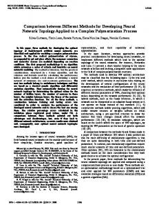
Two global, high resolution digital elevation models (DEMs), namely the Shuttle Radar Topography Mission (SRTM) DEM (USGS, 2006; Farr & Cobrick, 2000) and the Aster Global DEM (GDEM) (METI and NASA, 2011. Weepener et al. (2012) showed that such DEMs can be employed to delineate connected flow paths with flow direction and stream orders. However, flow paths cannot directly be interpreted as stream lines as the density of streams varies. This is illustrated in Figure 1 which shows the variation between flow paths derived from the same source (SRTM DEM) by two different studies. Figure 1A illustrates streams digitised by NGI compared to flow paths derived from the SRTM DEM in Figure 1B by Lehner et al. (2006) and Figure 1C by Weepener et al. (2012).
• Figure 1 (A) Streams digitised by NGI compare to flow paths derived from the SRTM DEM by (B) Lehner et al. (2006) and (C) Weepener et al. (2012).
1.2
Aim and Objectives
The aim was to develop a semi-automated methodology for creating a robust, country wide, accurate river network coverage for use in GIS projects and other planning initiatives in South Africa. This was achieved by applying the following objectives in two selected catchments: •
•
Creation of river networks through improvement of 1:50 000 river lines from NGI. River lines should be seamlessly connected, contain flow direction and attributes such as stream order and perennial status Adopting suitable modelling approach to select river lines from SRTM flow paths for trans-boundary catchment areas.
2
•
• 1.3
Mapping of vegetation from remote sensing data, as supportive information in arid environments, such as the D42 study site, where trees are sometimes confined to the banks of ephemeral rivers. Mapping of open water bodies from remote sensing imagery as supportive information in identifying river lines and perennial status of river. Research approach
It is proposed here to develop a semi-automatic methodology to compile, a robust and accurate river-network coverage for use in GIS projects. The methodology will be implemented on two selected catchments and aim to produce a network that will contain rivers similar to the 1:250 000 scale topographic maps at an accuracy that is equivalent to the 1:50 000 scale (the intention is for the whole country to be completed with follow-up projects). Criteria for selecting the two catchments are described in Section 2. The methodology developed in this study will be repeatable and applicable to the remaining catchments in South Africa. Figure 2 provides a schematic presentation of the processes applied in this project to create river networks.
3
Figure 2 Schematic presentation of the processes applied to create river networks.
4
1.4
The structure of the report
This project report is organised into five main chapters as follows: Chapter 1 provide the introduction which will focus on the background of the research and stating the problem statement, subsequently resulting in the highlighting of the aims and objectives. Chapter 2 describe the two study areas and baseline datasets of the project. Chapter 3 provide the methodology followed to develop river networks for the two study areas. The results and discussion is provided in chapter 4. Finally chapter 5 presents the conclusions from the study and recommendations.
2
DESCRIPTION OF STUDY AREAS AND BASELINE DATASETS.
Two catchments were selected for this study on the basis of the following criteria: •
Rainfall was used as one of the criteria in order to ensure inclusion of areas with markedly different rainfall regimes. Because of this consideration, one study area was in high rainfall area and the other in a low rainfall area. This parameterization was reasoned to be ideal for confident digitization of river lines from SPOT 5 images in the high rainfall regime, which is associated with active channels that can easily be identified from these images, while it is very difficult to map river lines in dry areas because most rivers are extremely intermittent to the extent that they are difficult to identify on images covering flat and sandy landscapes.
•
One study area to be on the border of South Africa to test the continuity of the dataset when it changes over to using SRTM flow paths only;
The procedures described in this report were only applied to the two study areas. Input datasets were however selected to cover the whole country and to be readily available, in order to expand the project to the rest of the country when required. Some regional datasets were required for the trans boundary area of catchment D42. Both the national and regional datasets that were used in this project will be described. 2.1
Molopo catchment
The Molopo catchment (Tertiary catchment D42) falls in a low rainfall regime area with a ground water mean annual recharge of only 0.1 to 5 mm and is located on the border of South Africa, Botswana and Namibia. The area is drained by the Nossob, Auob and Molopo rivers and is 25 000 000 ha in size of which 5 700 000 ha (23%) is within the borders of South Africa. Most of catchment D42 receives between 100 mm and 300 mm annual rainfall with the exception of the Eastern part of the catchment as well as the Western part in Namibia, which both receive more than 300 mm annual rainfall. Figure 3 illustrates the main tributaries of the Molopo catchment.
5
Figure 3 The main tributaries of the Molopo catchment. The Namibian part of the Stampriet artesian aquifer basin is indicated in yellow.
Tertiary catchment D42 is drained through the Molopo river into the Orange river just downstream from the Augrabies waterfall. The Molopo- and Kuruman rivers originate in catchment D41, which was not included in this study. The Kuruman River originates south east of Kuruman, where it is fed by various springs, most notably the Great Koning Eye, Little Koning Eye and the Kuruman Eye, while the Molopo River emanates from the area to the east of Mafikeng, where it is fed by various springs, most notably the Molopo Eye and the Grootfontein Eye. The Kuruman river has its confluence with the Molopo River at Andriesvale, in close proximity to the Nossob/Molopo confluence. The Molopo River surface flows decreased significantly and are not reaching the Main stem of the Orange River anymore (van Veelen and Baker, 2009). Spinage (2012) writes that the Molopo is known to have broken its banks in 1894 below its confluence with the Kuruman because of flooding in the latter and sediment in the former. Moffat (1842) asserted it was once a large river emptying itself into the Gariep at a distance below the waterfall. The main river bed of the Molopo river is currently covered by sand dunes that cross the original path at 90 degrees. In the year 2000 when the Molopo was in flood the water ended
6
up in a pan about 6 kilometres west from the place where the Molopo previously turned south. Rivers in catchment D42 do not really have smaller tributaries. This is mainly caused be the low rainfall, relative flat terrain and the Kalahari sand dunes, which covers most of the catchment. Small streams do appear in dune streets, but ends quickly in interdune depressions or in one of the numerous pans in the area. The large rivers are however well defined with wide sand beds and often deeply carved into the landscape. Indicating that there was previously significantly more water flow than is currently the case. The two main rivers that flow into catchment D42 from Namibia are the Nossob and Auob rivers. The confluence of the Nossob and Auob is near Twee rivieren, the main entrance to the Kgalagadi trans frontier park. Most of the water in the Namibian part of catchment D42 is accumulated in the Khomas Hochland Plateau, which receives between 300 mm and 450 mm rainfall per year. The main rivers in the Khomas Hochland Plateau are the following: • •
The White Nossob and Black Nossob join each other to form the Nossob near the edge of the plateau The confluence of the Olifants and Seeis is also near the edge of the plateau to form the Olifants
Elevation ranges from 450 m at the confluence of the Molopo into the Orange to 2450 at the upper reaches of the Oanob river in the Khomas Hochland Plateau. Towards the West of the catchment (In Namibia) the Oanob receives its water from both the Khomas Hochland and Rehoboth Plateaus. The Oanob river ends just before the start of the Witvlei spruit (near the town Kalkrand), which joins the Auob river to form the Auob river at Stampriet. The Oanob river most probably feeds into the Stampriet Artesian Aquifer. There are a number of dams in the upper reaches of the rivers in the Namibian part of the catchment (van Veelen and Baker, 2009), however, there are no significant rivers or dams in the Botswana part of catchment D42. The Otjivero Main Dam and Otjivero Silt Dam are located on the upper reaches of the White Nossob River in Namibia, approximately 100 km to the to the east of Windhoek. The Daan Viljoen Dam and Tilda Viljoen Dam are located at Gobabis. The Daan Viljoen Dam is an in-channel dam on the Black Nossob River, which impounds flood waters. The water is then pumped into the larger Tilda Viljoen Dam (offchannel), located nearby. Water is also transferred from the Otjivero Main Dam into the Tilda Viljoen Dam via a 110 km pumped pipeline. The drainage systems in the arid to semi-arid areas of the study area, have become defunct. These characteristics reflect the long and varied climatic and tectonic history of the continent and its distinctive topographic arrangement. In arid environments, such as the D42 study site, trees are sometimes confined to the banks of ephemeral rivers. Apart from short-lived surface waters that remain after rainstorms, most water resources are underground and are there for difficult to map using remote sensing. The dominant soils in the arid and semi-arid parts of the catchment comprises Arenosols, or soils developed on transported soils in which the degree of soil formation and horizon differentiation is either weak or absent. Particular characteristics of Arenosols are low reserves of weatherable minerals and low silt: clay ratios. Colours are usually red in upland sites and dune ridges, yellow in flat areas, and grey in bottomland sites (in the major drainage lines). The parent material of Arenosols is aeolian sand or sand derived from
7
aeolian or through the deposition of extensive sheets of pedisediment or hillwash as escarpments receded and pediments came to dominate the landscape. Units of the Kalahari Group constitute the most extensive body of terrestrial sediments of Cenozoic age in in southern Africa. Isopachs of the Kalahari Group show very clearly the presence of large paleovalley systems where thicknesses of Kalahari Group sediments are as great as 210 m. Paleovalleys run in a north-south direction between ridges of Olifantshoek and Transvaal Supergroup rocks and link up with a large valley running northeast-southwest along the Botswana border (Partridge, et al., 2006). Throughout the area the thickest part of the Kalahari appear to coincide with the occurrence of Dwyka Group rocks, and deposition of Kalahari Group sediments may have been partly controlled by the presence of Dwyka valleys. The Kalahari basin formed as a response to the down-warping of the interior of southern Africa, probably in the Late Cretaceous. The down-warping, along with possible uplift along epeirogenic axes, back-tilted rivers into the newly formed Kalahari basin and resulted in deposition of the Kalahari Group (Haddon & McCarthy, 2005). The authors also indicate that a period of relative stability during the mid-Miocene saw the silcretisation and calcretisation of the older Kalahari Group lithologies. Studies have shown that a combination of the relatively low permeability of the Kalahari sands and the low rainfall prevalent in the study area precludes recharge of groundwater aquifers by rainfall where sand cover exceeds about 15 m. It is therefore, assumed that the relatively good aquifers formed by the lower units of the Kalahari Group are recharged laterally from distant sources. In some areas, such as around Stampriet in Namibia, artesian conditions are present and analysis of these waters indicates slow replenishment over tens of thousands of years (Vogel et al.,1981). Table 1 lists recorded dates when the main rivers in the Molopo catchment were in flood. Table 1 Recorded floods in the Molopo catchment (adapted from Spinage, 2012)
Year 1806 1820 1879 1891-1892 1894 1896 1915 1917-1918 1920 1933-1934 1963 1974-1977 1987 1988-1989 2000 2014
Kuruman
Molopo
Nossob *
Auob
* * *
* * * *
* *
* *
* * *
*
* *
* * * * *
* *
*
8
*
2.2
The Mzimvubu River Catchment
The Mzimvubu River Catchment (Secondary catchment T3) is classified as a primary catchment and falls in a sub-humid climate with a ground water mean annual recharge of 12 to 70 mm and is located in the Eastern Cape Province and partially in KwaZulu-Natal. It has a drainage area of 19 826 km2 and a flow length of approximately 350 km from north to south. The Mzimvubu River takes its source from the Drakensberg and is fed by mainly 5 tertiary rivers/catchments namely the Tsitsa, Tina, Kinira, Mzimvubu and Mzintlava, from west to east respectively. After a flow length of approximately 200 km, the Tsitsa River flows into the Tina River, which flows into to Mzimvubu River less than 5 km downstream from abovementioned confluence. The Kinira River flows into the Mzimvubu after a flow length of approximately 150 km, whereas the Mzintlava River flows into the Mzimvubu River after a flow length of approximately 200 km. Approximately 50 km northwest from Port St Johns, the Mzimvubu River continues to meander through several deep gorges until reaching the main catchment outlet in the ocean at Port St Johns. With the Mzimvubu river forming tertiary catchment T36 from the river mouth up to the confluence of the Tina and Tsitsa rivers which form respectively tertiary catchments T34 and T35. Tertiary catchment T32 are upstream from the confluence of the Mzimvubu and Kinira rivers, while T33 covers the area of the Kinira river as well as the area between the confluences of the Mzimvubu river with the Mzintlava and Tina rivers. The Mzintlava river forms tertiary catchment T31. Figure 4 illustrates the catchment boundaries with the main rivers.
9
Figure 4 The catchment boundaries with the main rivers of the Mzimvubu catchment.
Connectivity of the main rivers mentioned above is not influenced by large dams, but several small dams occur in their tributaries along the axial valleys. A total of 104 relatively large farm dams and reservoirs, ranging between ≤0.1 and 80 ha, have been mapped from SPOT 5 imagery by Le Roux, 2014). The three largest dams in the catchment are Crystal Springs in T32C, Roodeberg Dam in T32B and Mountain Dam in T33A with capacities of just over 1 million m3 (Midgley, Pitman and Middleton, 1990). The rivers in the catchment are fed by several tributaries and therefore have a relatively high drainage density. This is mainly caused by high rainfall and complex landforms. The climate is characterized as sub-humid with the mean annual rainfall ranging from 625 mm in the lower inland plains to 1,415 mm in the mountain chains. Landforms range from very steep mountain slopes (40%) of the Drakensberg to gently undulating footslopes (2%) and nearly level valley floors. Elevation range from sea level at the catchment outlet in the southeast to 3,000 m in the Drakensberg Mountains bordering Lesotho. The catchment therefore has a significant drop in elevation from the upper reaches of the Tina river in the Drakensberg to the mouth of the Mzimvubu river in the Indian ocean. The catchment is characterised by three prominent/steep escarpment areas including the Drakensberg
10
Mountains also known as the Great Escarpment, followed by mountain ranges that separates the Highlands from the mid-slopes, and a third relatively steep drop in elevation approximately 50 km inland from the coast. The geology consists of a succession of sedimentary layers of the Quaternary age (Council for Geoscience, 2007). The coastal region is dominated by Table Mountain sandstone with steep sea cliffs characteristic of the Wild Coast. A major fault, caused by the breakup of Gondwanaland approximately 130 million years ago, separates the sandstone cliffs and a section of shale rich units of the Ecca series further inland. Approximately 10 km inland from the outlet, is another geological fault worth mentioning. This fault consists of a large Karoo dolerite sill that protrudes through the catchment, separating the southern section of shale units of the Ecca series and a northern section of Diamictite of the Dwyka series (polymictic clasts, set in a poorly sorted, fine-grained matrix). Further inland, the oldest materials are Adelaide mudrock with subordinate sandstone. The latter is succeeded by various layers of sedimentary deposits including mudstones of the Tarkastad, Molteno and Elliot Formations. The next layer consists of fine-grained sandstone and siltstone of the Clarens Formation capped by Drakensberg basaltic lava in the most upper catchment area. Formations are all characterized by Karoo dolerite injections appearing as sills, sheets and dykes. In addition to alongside river valleys, a large patch of alluvium deposits occur just north of Cedarville. 2.3
National datasets
National baseline datasets that were used in this project include: •
Pan-Sharpened colour mosaics of SPOT 5 imagery prepared by South African National Space Agency (SANSA)
•
Aerial photography captured by the Chief Directorate: National Geospatial Information (NGI) of the Department of Rural Development and Land Reform.
•
River centre lines captured by NGI.
•
Gauging station data
2.3.1
SPOT 5 imagery
The images acquired by SPOT Earth Observation Satellites are useful for studying, monitoring, forecasting and managing natural resources and human activities. The SPOT-5 earth observation satellite was placed into orbit in May 2002. The satellite provides an ideal balance between high resolution and wide-area coverage suitable for application at medium scale of between 1:25 000 and 1:10 000. The SPOT 5 satellite completes a circular orbit of the earth every 26 days has a swath width of 60 km. The Spot 5 multispectral satellite sensor captures images in five bands. The characteristics of the spectral bands are illustrated in Table 2.
11
Table 2 Spectral bands and resolutions of SPOT 5 imagery (Astrium, 2012).
Spectral bands
Pixel size
Panchromatic Green Red Near infrared Shortwave infrared (SWIR)
2.5 m 10 m 10 m 10 m 20 m
Spectral resolution 0.48-0.71 µm 0.50-0.59 µm 0.61-0.68 µm 0.78-0.89 µm 1.58-1.75 µm
SPOT uses a unique A21 code for each scene (Astrium, 2013). For example: 51354050611090808381T, is better shown as 5-135,405-061109-080838-1-T where: • • • • • •
5 is the satellite number (scene acquired by SPOT 5); 135,405 are the coordinates of the scene on the SPOT Grid Reference System (GRS); 061109 is the acquisition date in YYMMDD format (i.e. 9 November 2006); 080838 is the acquisition time in HHMMSS format (i.e. 08 hours, 08 minutes, 38 seconds UTC); 1 is the instrument number (here: HRV1); T is the spectral mode (here: T for panchromatic).
The last letter of the code indicates the type of image. For example: T = panchromatic J = multispectral The South African National Space Agency (SANSA) prepared annual Pan-Sharpened colour mosaics for the whole country from 2006 to 2011. The Pan-Sharpened mosaics have a pixel size of 2.5 m, whereas as the original bands have a pixel size of 10 m. SANSA use the A21 code of SPOT for the pan sharpened images, with the letters JT at the end. The images used in the mosaics were chosen because they were cloud free and obtained generally at random periods during the year, although the majority were obtained during winter when cloud cover is minimal over most parts of the country. The processing of the imagery to Level 3B involved orthorectification (positioning and elimination of distortion in the images), pansharpening (transforming lower resolution colour images into higher resolution colour images), true colour conversion, colour balancing, manual editing to reduce cloud cover and eliminate “no data areas” (Campbell, 2012). 2.3.2
NGI aerial photography
Since 2008, all images secured by National Geospatial Information (NGI) were acquired by High resolution (HRes) digital sensors in both colour (RGB) and colour infra-red (CIR ) at a Ground Sample Distance (GSD) of 0.5 m. The aim is to produce a new set of imagery covering the whole country every three years. See Tables 3 and 4 for the spectral bands and resolutions of RGB and CIR images.
12
Table 3 Spectral bands and resolutions of RGB images captured by NGI.
Spectral bands Blue Green Red
Pixel size 0.5 m 0.5 m 0.5 m
Spectral resolution 0.4-0.58 µm 0.5-0.65 µm 0.59-0.675 µm
Table 4 Spectral bands and resolutions of CIR images captured by NGI.
Spectral bands Near infrared Green Red
Pixel size 0.5 m 0.5 m 0.5 m
Spectral resolution 0.675-0.85 µm 0.5-0.65 µm 0.59-0.675 µm
RGB (Red, Green, Blue) ortho-rectified images are used as the basis for NGI’s major products including being a major stand-alone product supplied to clients. However NGI only ortho-rectify certain areas in CIR, as required for their internal LandUse/LandCover purposes. The CIR images are a prerequisite for the two proposed procedures for signature-based discrimination of rivers. There are currently no orthorectified CIR images available for the two study areas of this project, but it is believed that this dataset may be useful in future for other areas. NGI aerial photos were therefor only used as backdrop during visual inspection of the accuracy of river lines in this study. 2.3.3
River centre lines
The South African river centre line data sets were developed as part of the 1:50 000 topographic map series, dating back to 1937 (Wonnacott, 2010). The Chief Directorate: National Geo-spatial Information (NGI), previously Chief Directorate: Surveys and Mapping (CDSM), of the Department of Rural Development and Land Reform is responsible for developing and maintaining these maps (Duncan & Smit, 2012). Vorster (2003) provides a brief history of the development of digital vector data sets for South Africa. Capture of GIS data from the1:500,000 national map series would commence in 1988 with the acquisition of the first GIS system, named ReGIS. The pilot project would be completed in 1992 and would serve as a prototype for the eventual National Topographic Information System (NTIS). Maintenance of this pilot 1:500,000 database ceased in 1996. The second stage of development consisted of the creation of the NTIS proper, consisting of the raster to vector conversion of the 1:50,000 national map series. The raster to vector conversion process commenced in 1988 with the GIS population and structuring commencing in 1992 and completed in 1997. Intergraph’s GeoMedia Professional 3.0 replaced the ReGIS GIS in 1999. Post 1997 has seen continued maintenance of the system where newly compiled topographically captured data has replaced the initial data captured, which is cartographic in nature (Vorster, 2003). Various feature types, omitted during the initial capture, have been captured and general maintenance and partial clean-up procedures have been implemented. The integrated Topographic Information System (iTIS) portal is currently being developed by NGI (2013). It will provide intranet and internet users access to the iTIS using a Web Feature
13
data Server (WFS), Geography Markup Language (GML) data Server, Web Map Service (WMS) and access to imagery. The fields in the dataset received from NGI are illustrated in Table 5. Table 5 Fields in iTIS data
GID CUID FEAT_T_ID FEAT_TYPE JOB_NR EST_RV_DAT
FEA_R_DATE ATT_R_DATE CAP_SOURCE CAP_METHOD SOURCE_DES SOURCE_CUR
SOURCE_ACC ENTITY_NAM GEOM_TYPE SAGD_F_TYP SAGD_S_TYP SAGD_F_DES
SAGD_S_DES PIPE_TYPE Edited Shape_Leng Enabled
Of specific interest are the “ENTITY_NAM” and “FEAT_TYPE” fields, which contain the name of the river and perennial status respectively. The CUID field is not currently populated, but will be used in future to uniquely identify any feature in the system. The river centre lines on the topographic maps were initially developed for presentation purposes and were not suitable for numerical hydraulic/hydrological modelling as they were not seamlessly connected and without flow direction. With the continuous improvements that NGI make to the topographic data it is necessary to update these datasets from time to time for modelling purposes. 2.3.4
Gauging station data
The Department of Water Affairs hosts several data sets for the monitoring of surface water, which includes (DWA, 2012): • • • • • •
near real-time stage, flows and rainfall received from more than 400 stations; daily flows, dam level and rainfall information in the Vaal and Orange River System; weekly state of approximately 180 dams in South Africa; dam Optimisation: Routing through dams showing capacity, inflow and outflow; routed hydrographs showing actual and predicted stage and flows in major rivers in South Africa; and flow lines and levels over a range of flows from Vaal to Bloemhof Dam.
Station data can be downloaded from https://www.dwa.gov.za/hydrology/hymain.aspx. 2.4
Regional datasets
Regional baseline datasets that were used in this project include: • • • • • •
Hydrologically improved DEM and flow paths Landsat 8 imagery Hydrologically improved DEM Dominant major soil group in the SOTER data Landcover Rainfall
14
2.4.1
Landsat 8 imagery
Landsat 8 images consist of nine spectral bands with a spatial resolution of 30 meters for Bands 1 to 7 and 9 (USGS, 2014). The resolution for Band 8 (panchromatic) is 15 meters. Thermal bands 10 and 11 are useful in providing more accurate surface temperatures and are collected at 100 meters. Approximate scene size is 170 km north-south by 183 km eastwest. The characteristics of the spectral bands are illustrated in Table 6. Table 6 Spectral bands and resolutions of Landsat 8 imagery (USGS, 2014)
Bands
Wavelength
Pixel size
Band 1 – Coastal aerosol
0.43-0.45 µm
30 m
Band 2 – Blue
0.45-0.51 µm
30 m
Band 3 – Green
0.53-0.59 µm
30 m
Band 4 – Red
0.64-0.67 µm
30 m
Band 5 – Near Infrared (NIR)
0.85-0.88 µm
30 m
Band 6 – SWIR 1
1.57-1.65 µm
30 m
Band 7 – SWIR 2
2.11-2.29 µm
30 m
Band 8 – Panchromatic
0.50-0.68 µm
15 m
Band 9 – Cirrus Band 10 – Thermal Infrared (TIRS) 1 Band 11 – Thermal Infrared (TIRS) 2
1.36-1.38 µm
30 m
10.60-11.19 µm
100 * (30) m
11.50-12.51 µm
100 * (30) m
Landsat 8 was launched on the 11th of February 2013. Landsat 8 data as well as data from other satellites in NASA’s Landsat series of satellites are provided for free on EarthExplorer (http://earthexplorer.usgs.gov/) and GloVis (http://glovis.usgs.gov/) within 24 hours of acquisition. With the first Landsat satellite being launched in 1972 this data set provide a wealth of information for future research. 2.4.2
Hydrologically improved DEM
A Digital Elevation Model (DEM) is a collection of data files that contain the elevation of the terrain over a specified area, usually at a fixed grid interval over the surface of the earth and which can be displayed as a three-dimensional layer of the land surface. Data from NASA’s Shuttle Radar Topography Mission (SRTM) (CGIAR, 2008) provides 90 m Digital Elevation Model (DEM) coverage for approximately 80% of the earth’s surface. The DEM was created from dual stereoscopic radar signals, providing topographical detail suitable for mapping scales of 1:50 000 and coarser. The DEM files have been joined into a seamless global coverage (like a mosaic), and are available for download as 5o x 5o tiles. The official version (2.1) of the data can be downloaded as tiles from http://dds.cr.usgs.gov/srtm/. Various unofficial versions of the data exist, e.g. version 3 and 4 (http://srtm.csi.cgiar.org), but these are heavily processed and positional shifts have been introduced.. A continuous DEM was created by Weepener et al. (2012) for southern Africa by filling voids in the SRTM DEM, version 2.1, using 20 m contour lines and the ASTER Global DEM. The resulting DEM covered the area between 19ºS and 35ºS and 12ºE and 36ºE. It includes the whole of South
15
Africa, Swaziland and Lesotho and large parts of Namibia, Botswana, Zimbabwe and Mozambique. The void filled DEM still contained 4 203 626 sinks (areas surrounded by higher elevation values) which made the DEM unreliable for delineating flow paths and catchment areas. To overcome this limitation, the DEM was hydrologically improved by carving the RQS 1: 500 000 rivers into the DEM and applying an automated impact reduction approach. The impacts of sink filling and channel carving were compared for each sink to choose the appropriate method. 2.4.3
Dominant major soil group in the SOTER (FAO, 1995) data
The world soils and terrain (SOTER) database provide a uniform resource map for the southern African region at a scale of 1:1 000 000. SOTER units consist of a distinctive, often repetitive, pattern of land form, lithology, surface form, slope, parent material and soil. The soil classification used in the short description of the dominant major soil groups as defined by the World Reference Base for Soil Resources (FAO, 2007) that can be found in catchment D42 are listed here:
2.4.3.1 Arenosols Arenosols comprise sandy soils, including both soils developed in residual sands after in situ weathering of usually quartz-rich sediments or rock, and soils developed in recently deposited sands such as dunes in deserts and beach lands. Corresponding soils in other classification systems include Psamments of the US Soil Taxonomy and the sols minéraux bruts and sols peu évolués in the French classification system of the CPCS (1967). Many Arenosols belong to Arenic Rudosols (Australia), Psammozems (Russian Federation) and Neossolos (Brazil). 2.4.3.2 Calcisols Calcisols accommodate soils in which there is substantial secondary accumulation of lime. Calcisols are common in highly calcareous parent materials and widespread in arid and semi-arid environments. Formerly used soil names for many Calcisols include Desert soils and Takyrs. In the US Soil Taxonomy, most of them belong to the Calcids. 2.4.3.3 Cambisols Cambisols combine soils with at least an incipient subsurface soil formation. Transformation of parent material is evident from structure formation and mostly brownish discoloration, increasing clay percentage, and/or carbonate removal. Other soil classification systems refer to many Cambisols as: Braunerden (Germany), Sols bruns (France), Brown soils/Brown Forest soils (older US systems), or Burozems (Russian Federation). FAO coined the name Cambisols, adopted by Brazil (Cambissolos); US Soil Taxonomy classifies most of these soils as Inceptisols. 2.4.3.4 Leptosols Leptosols are very shallow soils over continuous rock and soils that are extremely gravelly and/or stony. Leptosols are azonal soils and particularly common in mountainous regions. Leptosols include the: Lithosols of the Soil Map of the World (FAO-UNESCO, 1971-1981); 16
Lithic subgroups of the Entisol order (United States of America); Leptic Rudosols and Tenosols (Australia); and Petrozems and Litozems (Russian Federation). In many national systems, Leptosols on calcareous rocks belong to Rendzinas, and those on other rocks to Rankers. Continuous rock at the surface is considered non-soil in many soil classification systems. 2.4.3.5 Regosols Regosols form a taxonomic remnant group containing all soils that could not be accommodated in any of the other RSGs. In practice, Regosols are very weakly developed mineral soils in unconsolidated materials that do not have a mollic or umbric horizon, are not very shallow or very rich in gravels (Leptosols), sandy (Arenosols) or with fluvic materials (Fluvisols). Regosols are extensive in eroding lands, particularly in arid and semi-arid areas and in mountainous terrain. Many Regosols correlate with soil taxa that are marked by incipient soil formation such as: Entisols (United States) 2.4.4
Land Cover
The Global Land Cover 2000 (GLC, 2000) map for Africa was used to evaluate land cover in the study area (JRC, 2003; Mayaux et al., 2003). The GLC 2000 database has been produced by an international partnership of 30 research groups coordinated by the European Commission’s Joint Research Centre (Bartholomé and Belward, 2005). The database contains two levels of land cover information – detailed, regionally optimized land cover legends for each continent and a less thematically detailed global legend that harmonizes regional legends into one consistent product. The land cover maps are based on daily data from the VEGETATION sensor on-board SPOT 4, though mapping of some regions involved use of data from other Earth observing sensors to resolve specific issues. Some land cover classes appear only in Namibia. These are: • • •
Closed grassland Deciduous woodland Deciduous shrub land with sparse trees
The following natural vegetation landcover classes can be found in all three countries of tertiary catchment D42: • • •
Open grassland with sparse shrubs Open grassland Sparse grassland
Mayaux et al. (2003) describe these landcover classes. 2.4.4.1 Open grassland with sparse shrubs Herbaceous cover between 15% and 40% and shrub canopy cover less than 20% (Mayaux et al., 2003). In dry conditions (