An Operational Coastal Wave Forecasting Model for New Jersey and Long Island Waters By
Nickitas Georgas, Alan F. Blumberg, Ph.D., and Thomas O. Herrington, Ph.D. The Center for Maritime Systems Stevens Institute of Technology Castle Point on Hudson, Hoboken, NJ 07030
[email protected]
Page 30
Shore & Beach ■ Vol. 75, No. 2 ■ Spring 2007
ABSTRACT A high-resolution (approximately 1 km) wave forecasting model has been developed for the coastal waters of New York and New Jersey through a two-year National Weather-Service (NWS)-funded COMET project and through the collaboration of researchers from the Stevens Institute of Technology (Stevens), in Hoboken, NJ, and NWS marine forecasters from the Mount Holly, NJ, forecast office. The wave model has been
continuously operational since 15 May 2006, each day producing 48-hour graphical forecasts for significant wave height, wave direction, and wave period. Marine forecasting products are available to Mount Holly NWS forecasters, as well as to the general public, through the New York Harbor Observation and Prediction System (NYHOPS) Web site http:// www.stevens.edu/maritimeforecast, designed and maintained by Stevens.
ADDITIONAL KEYWORDS: Marine meteorology forecasts, Operational Coastal Oceanography. Paper submitted and accepted 1 August 2006 for the 2006 ASBPA Educational Award.
T
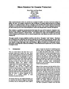
he main goal of this study was to develop an operational wave forecasting system that would be used to disseminate high-resolution forecasts of the wave environment along the shore of New York and New Jersey by means of the existing New York Harbor Observation and Prediction System (NYHOPS) Web site created and maintained by the Stevens Institute of Technology (Stevens). The primary need for this system was that the current wave forecast models available from the National Weather Service (NWS) resolve wave fields at a resolution of 25 km, limiting their use in terms of understanding the complex coastal environment and the factors most important to wave propagation across the shelf waters offshore of New York and New Jersey. Another purpose for this study was to provide a testing environment for new, increasingly sophisticated, wave models. The new, high-resolution (approximately 1 km) forecasting system was successfully designed through collaborative work by NWS forecasters and Stevens engineers. WAVE FORECAST SYSTEM DESCRIPTION The NYHOPS Coastal Wave Model (NYHOPS-CWM, Figure 1) is based on the National Oceanic & Atmospheric Figure 1 (facing page). Map shows the NYHOPS Coastal Wave Modeling system: Bathymetry (m below Mean Sea Level), resolution (approximately 1 km), Surface (ETA and WRF wind) and Open Ocean (WNA WaveWatch III) boundary forcing sources, and observation network stations.
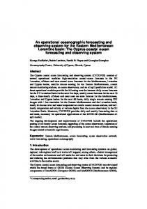
Figure 2. Schematic shows the NYHOPS-CWM framework: 48-hour forecasts are initialized daily with initial conditions (IC) taken from the previous day hindcast. Model forcing is provided by winds and waves forecasts created by mesoscale NOAA and NWS models, acquired through the World Wide Web (WWW), and cached locally on Stevens computers to avoid service interruptions. Model forecast output is presently made available daily on the NYHOPS Web site.
Shore & Beach ■ Vol. 75, No. 2 ■ Spring 2007
Page 31
Administration (NOAA) Great Lakes Environmental Research Laboratory model (GLERL model, Donelan 1977; Schwab et al. 1984), a two-dimensional, parametric, dynamic model of windwave growth, propagation, and decay, modified to accept open boundary forcing through specification of significant wave height at the oceanic boundary. The modified GLERL model has been incorporated into the three-dimensional, curvilinear, Princeton Ocean Model (POM) framework of Blumberg and Mellor (1987), in its shallow water derivative model form, ECOMSED (Estuarine and Coastal Ocean Model with Sediment Transport — HydroQual Inc. 2001).
Marine Meteorology Wind Field (m/s) 3 September 2006 00:00-01:00
Wind forcing within the NYHOPSCWM domain (Figure 1) is currently provided from forecasted wind fields derived from the NOAA/NWS/National Centers for Environmental Prediction (NCEP) Weather Research and Forecasting North-American Mesoscale Model (WRF-NMM), optimally interpolated to the NYHOPS-CWM high-resolution grid. Prior to 20 June 2006, when the NCEP WRF-NMM became operational, wind forcing was provided by NOAA/ NWS/NCEP’s North American 12 km Eta model, on the same grid. Open ocean boundary forcing to NYHOPS-CWM is derived through optimal interpolation of forecasted wave conditions provided from the NOAA Western North Atlantic (WNA) WaveWatch III (WWIII) model at 15-min resolution.
Marine Meteorology Composite (m) 3 September 2006 00:00-01:00
The daily prediction system is scheduled to simulate 72 hours — 24 hours in the past (the hindcast mode) and then 48 hours into the future (the forecast mode). A schematic of the flow of data in the prediction system is shown in Figure 2. The hindcast part of the cycle uses observed (not forecasted) forcing functions and a file is written out that forms the basis (initial conditions) for the next cycle.
Figure 3. Maps show (A) wind vectors and (B) predicted waves, posted for 3 September 2006 00:00-01:00 EDT on the NYHOPS-CWM Web site, during (Tropical) Storm Ernesto. Map (B) is a composite representation of the hourlyaveraged wave field predicted by NYHOPS-CWM: The scale bar depicts significant wave height ranging from well over 10 ft (>3m) to the north to less than a foot (